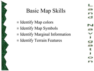
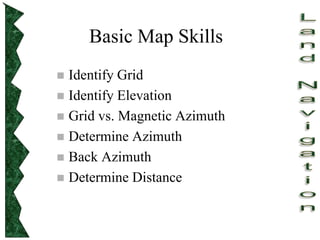
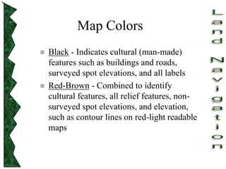
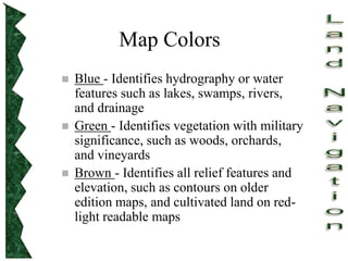
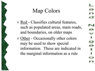
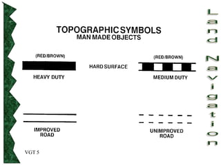
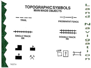
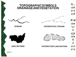
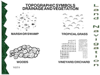
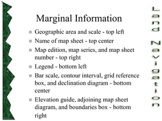
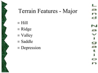
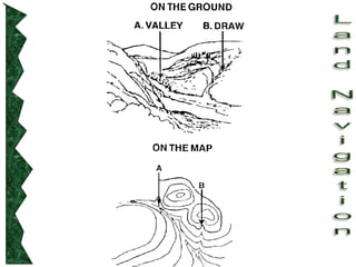
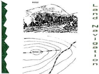
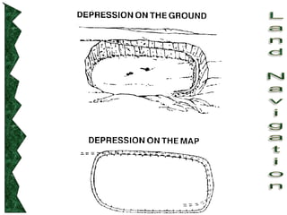
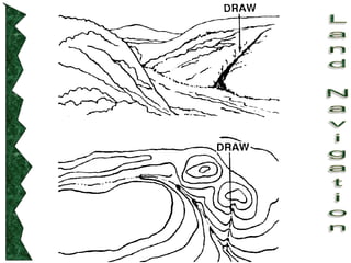
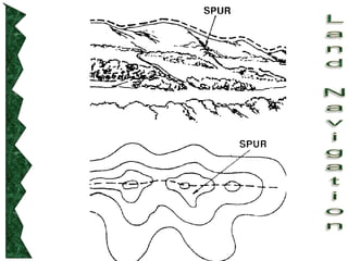
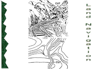
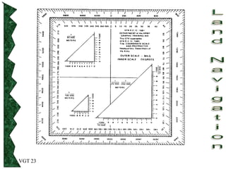
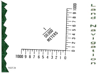
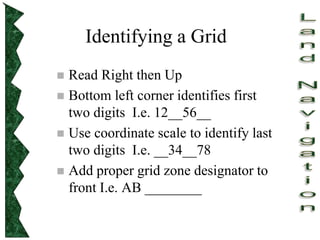
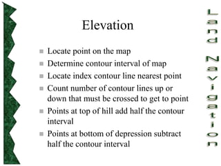
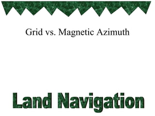
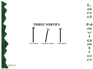
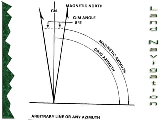
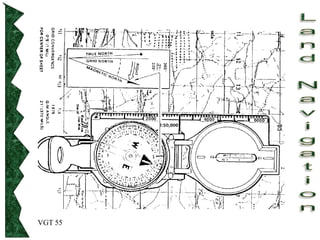
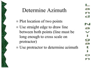
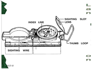
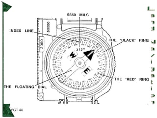
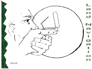
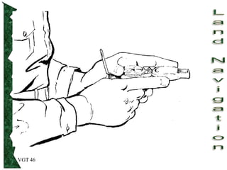
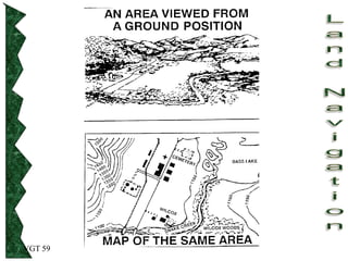
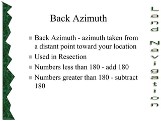
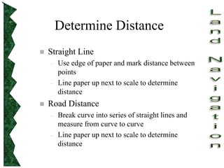
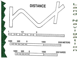
Land Navigation
Map Reading
Basic Map Skills
 Identify Map colors
 Identify Map Symbols
 Identify Marginal Information
 Identify Terrain Features
Basic Map Skills
 Identify Grid
 Identify Elevation
 Grid vs. Magnetic Azimuth
 Determine Azimuth
 Back Azimuth
 Determine Distance
Map Colors
 Black - Indicates cultural (man-made)
features such as buildings and roads,
surveyed spot elevations, and all labels
 Red-Brown - Combined to identify
cultural features, all relief features, non-
surveyed spot elevations, and elevation,
such as contour lines on red-light readable
maps
Map Colors
 Blue - Identifies hydrography or water
features such as lakes, swamps, rivers,
and drainage
 Green - Identifies vegetation with military
significance, such as woods, orchards,
and vineyards
 Brown - Identifies all relief features and
elevation, such as contours on older
edition maps, and cultivated land on red-
light readable maps
Map Colors
 Red - Classifies cultural features,
such as populated areas, main roads,
and boundaries, on older maps
 Other - Occasionally other colors
may be used to show special
information. These are indicated in
the marginal information as a rule
VGT 5
VGT 6
VGT 7
VGT 8
Identify Map Symbols
Refer to Legend
Marginal Information
 Geographic area and scale - top left
 Name of map sheet - top center
 Map edition, map series, and map sheet
number - top right
 Legend - bottom left
 Bar scale, contour interval, grid reference
box, and declination diagram - bottom
center
 Elevation guide, adjoining map sheet
diagram, and boundaries box - bottom
right
Terrain Features - Major
 Hill
 Ridge
 Valley
 Saddle
 Depression
Terrain Features - Minor
 Draw
 Spur
Terrain Features -
Supplementary
 Cliff
 Cut
 Fill
Identify a Grid
VGT 23
VGT 24
Identifying a Grid
 Read Right then Up
 Bottom left corner identifies first
two digits I.e. 12__56__
 Use coordinate scale to identify last
two digits I.e. __34__78
 Add proper grid zone designator to
front I.e. AB ________
Identify Elevation
Elevation
 Locate point on the map
 Determine contour interval of map
 Locate index contour line nearest point
 Count number of contour lines up or
down that must be crossed to get to point
 Points at top of hill add half the contour
interval
 Points at bottom of depression subtract
half the contour interval
Grid vs. Magnetic Azimuth
VGT 32
THREE NORTH'S
TRUE NORTH MAGNETIC NORTH GRID NORTH
G N
N
Determine Azimuth
VGT 55
Determine Azimuth
 Plot location of two points
 Use straight edge to draw line
between both points (line must be
long enough to cross scale on
protractor)
 Use protractor to determine azimuth
VGT 43
VGT 44
VGT 45
VGT 46
VGT 59
Determine Back Azimuth
Back Azimuth
 Back Azimuth - azimuth taken from
a distant point toward your location
 Used in Resection
 Numbers less than 180 - add 180
 Numbers greater than 180 - subtract
180
Determine Distance
Determine Distance
 Straight Line
– Use edge of paper and mark distance between
points
– Line paper up next to scale to determine
distance
 Road Distance
– Break curve into series of straight lines and
measure from curve to curve
– Line paper up next to scale to determine
distance
Advanced Skills
 Intersection
 Resection
VGT 40
PRACTICAL EXERCISE
TENINO
YOU ARE AT A STRUCTURE IN AN UNKNOWN LOCATION. YOU
DETERMINE THAT SPOT ELEVATION 215 IN GRID SQUARE
EG1686 IS ON A MAGNETIC AZIMUTH OF 358 1/2 DEGREES. YOU
ALSO SEE THE WATER TOWER IN GRID SQUARE EG1185. IT IS ON
A MAGNETIC AZIMUTH OF 290 DEGREES FROM YOUR POSITION.
DETERMINE WHICH STRUCTURE YOU ARE LOCATED AT TO
WITHIN 100 METERS.

Land-Navigation army basic requirement maps

  • 1.
  • 2.
    Basic Map Skills Identify Map colors  Identify Map Symbols  Identify Marginal Information  Identify Terrain Features
  • 3.
    Basic Map Skills Identify Grid  Identify Elevation  Grid vs. Magnetic Azimuth  Determine Azimuth  Back Azimuth  Determine Distance
  • 4.
    Map Colors  Black- Indicates cultural (man-made) features such as buildings and roads, surveyed spot elevations, and all labels  Red-Brown - Combined to identify cultural features, all relief features, non- surveyed spot elevations, and elevation, such as contour lines on red-light readable maps
  • 5.
    Map Colors  Blue- Identifies hydrography or water features such as lakes, swamps, rivers, and drainage  Green - Identifies vegetation with military significance, such as woods, orchards, and vineyards  Brown - Identifies all relief features and elevation, such as contours on older edition maps, and cultivated land on red- light readable maps
  • 6.
    Map Colors  Red- Classifies cultural features, such as populated areas, main roads, and boundaries, on older maps  Other - Occasionally other colors may be used to show special information. These are indicated in the marginal information as a rule
  • 7.
  • 8.
  • 9.
  • 10.
  • 11.
  • 12.
    Marginal Information  Geographicarea and scale - top left  Name of map sheet - top center  Map edition, map series, and map sheet number - top right  Legend - bottom left  Bar scale, contour interval, grid reference box, and declination diagram - bottom center  Elevation guide, adjoining map sheet diagram, and boundaries box - bottom right
  • 13.
    Terrain Features -Major  Hill  Ridge  Valley  Saddle  Depression
  • 14.
    Terrain Features -Minor  Draw  Spur
  • 15.
  • 26.
  • 27.
  • 28.
  • 29.
    Identifying a Grid Read Right then Up  Bottom left corner identifies first two digits I.e. 12__56__  Use coordinate scale to identify last two digits I.e. __34__78  Add proper grid zone designator to front I.e. AB ________
  • 30.
  • 31.
    Elevation  Locate pointon the map  Determine contour interval of map  Locate index contour line nearest point  Count number of contour lines up or down that must be crossed to get to point  Points at top of hill add half the contour interval  Points at bottom of depression subtract half the contour interval
  • 32.
  • 33.
    VGT 32 THREE NORTH'S TRUENORTH MAGNETIC NORTH GRID NORTH G N N
  • 35.
  • 36.
  • 37.
    Determine Azimuth  Plotlocation of two points  Use straight edge to draw line between both points (line must be long enough to cross scale on protractor)  Use protractor to determine azimuth
  • 38.
  • 39.
  • 40.
  • 41.
  • 42.
  • 43.
  • 44.
    Back Azimuth  BackAzimuth - azimuth taken from a distant point toward your location  Used in Resection  Numbers less than 180 - add 180  Numbers greater than 180 - subtract 180
  • 45.
  • 46.
    Determine Distance  StraightLine – Use edge of paper and mark distance between points – Line paper up next to scale to determine distance  Road Distance – Break curve into series of straight lines and measure from curve to curve – Line paper up next to scale to determine distance
  • 48.
  • 49.
    VGT 40 PRACTICAL EXERCISE TENINO YOUARE AT A STRUCTURE IN AN UNKNOWN LOCATION. YOU DETERMINE THAT SPOT ELEVATION 215 IN GRID SQUARE EG1686 IS ON A MAGNETIC AZIMUTH OF 358 1/2 DEGREES. YOU ALSO SEE THE WATER TOWER IN GRID SQUARE EG1185. IT IS ON A MAGNETIC AZIMUTH OF 290 DEGREES FROM YOUR POSITION. DETERMINE WHICH STRUCTURE YOU ARE LOCATED AT TO WITHIN 100 METERS.