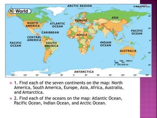
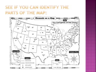
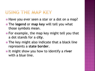
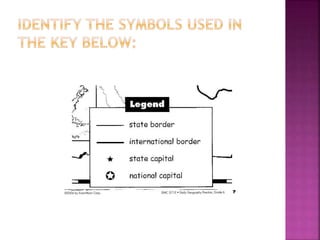
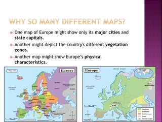
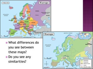
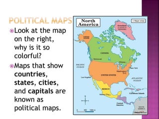
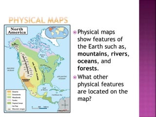
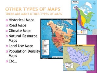
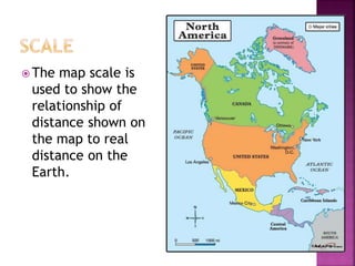
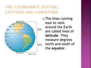
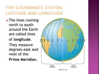
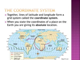
SlideShare a Scribd company logo
1 of 19
 To learn about the Earth, two tools you can
use are globes and maps.
 A globe is a model of the planet Earth as if
seeing it from outer space. A globe is round
and shows continents and oceans. There are
seven continents on Earth and four oceans.
 A map is a model of the Earth shown on a flat
surface. Maps are useful because you can
carry them with you.
 Let’s look at a map more closely…
 1. Find each of the seven continents on the map: North
America, South America, Europe, Asia, Africa, Australia,
and Antarctica.
 2. Find each of the oceans on the map: Atlantic Ocean,
Pacific Ocean, Indian Ocean, and Arctic Ocean.
 Every map has five important elements:
 Title
 Legend/Key
 Compass Rose
 Scale
 Inset Map
 Each element has a purpose:
 The title tells you the purpose of the map.
 The legend shows you what symbols on the map mean.
 The compass rose is a directional arrow that shows cardinal
and sometimes intermediate directions on a map.
 The scale is shown in both standard and metric measurements
and show distance between objects on the map.
 The inset map is a smaller map that shows a “larger” area of
land around the map.
 Have you ever seen a star or a dot on a map?
 The legend or map key will tell you what
those symbols mean.
 For example, the map key might tell you that
a dot stands for a city.
 The key might also indicate that a black line
represents a state border.
 It might show you how to identify a river
with a blue line.
 Different cartographers (map-makers) use
different map projections.
 Another reason for this difference is that
maps can be created to represent different
features of the same places.
 One map of Europe might show only its major cities and
state capitals.
 Another might depict the country's different vegetation
zones.
 Another map might show Europe’s physical
characteristics.
 What differences do
you see between
these maps?
 Do you see any
similarities?
Look at the map
on the right,
why is it so
colorful?
Maps that show
countries,
states, cities,
and capitals are
known as
political maps.
 Physical maps
show features of
the Earth such as,
mountains, rivers,
oceans, and
forests.
 What other
physical features
are located on the
map?
 Historical Maps
 Road Maps
 Climate Maps
 Natural Resource
Maps
 Land Use Maps
 Population Density
Maps
 Etc…
 The map scale is
used to show the
relationship of
distance shown on
the map to real
distance on the
Earth.
 On many maps you see crisscrossing lines
with numbers by them. These lines and
numbers form a grid system that allows
us to describe the absolute, or exact,
location of any place on Earth.
 The lines running
east to west
around the Earth
are called lines of
latitude. They
measure degrees
north and south of
the equator.
Maps101.com
 The lines running
north to south
around the Earth
are called lines
of longitude.
They measure
degrees east and
west of the
Prime Meridian.
Maps101.com
 Together, lines of latitude and longitude form a
grid system called the coordinate system.
 When you state the coordinates of a place on the
Earth you are giving its absolute location.
Maps101.com
Maps101.com

More Related Content

What's hot

Different Types of Maps
Different Types of MapsDifferent Types of Maps
Different Types of Maps
cpbrown10
 
Topographic maps presentation_mine
Topographic maps presentation_mineTopographic maps presentation_mine
Topographic maps presentation_mine
misterbatroms
 

What's hot (20)

Different Types of Maps
Different Types of MapsDifferent Types of Maps
Different Types of Maps
 
Map Reading
Map ReadingMap Reading
Map Reading
 
Types of maps
Types of mapsTypes of maps
Types of maps
 
The Mapping Skills
The Mapping SkillsThe Mapping Skills
The Mapping Skills
 
Parts of a Map
Parts of a MapParts of a Map
Parts of a Map
 
Types of Map Scales
Types of Map ScalesTypes of Map Scales
Types of Map Scales
 
Cartography
CartographyCartography
Cartography
 
Maps & globes
Maps & globesMaps & globes
Maps & globes
 
Map
MapMap
Map
 
Maps and globes
Maps and globesMaps and globes
Maps and globes
 
Map skills
Map skillsMap skills
Map skills
 
What is Geography
What is GeographyWhat is Geography
What is Geography
 
Maps ppt
Maps pptMaps ppt
Maps ppt
 
Maps, cartography and significances
Maps, cartography and significancesMaps, cartography and significances
Maps, cartography and significances
 
What is a Map?
What is a Map? What is a Map?
What is a Map?
 
Elements of a map
Elements of a mapElements of a map
Elements of a map
 
Time zones
Time zonesTime zones
Time zones
 
Latitude and longitude
Latitude and longitudeLatitude and longitude
Latitude and longitude
 
Maps
MapsMaps
Maps
 
Topographic maps presentation_mine
Topographic maps presentation_mineTopographic maps presentation_mine
Topographic maps presentation_mine
 

Viewers also liked

Geography: Different Kinds Of Maps
Geography: Different Kinds Of MapsGeography: Different Kinds Of Maps
Geography: Different Kinds Of Maps
Dan Klumper
 

Viewers also liked (9)

Geography: Different Kinds Of Maps
Geography: Different Kinds Of MapsGeography: Different Kinds Of Maps
Geography: Different Kinds Of Maps
 
Map Parts
Map PartsMap Parts
Map Parts
 
Lost in Cultural Translation
Lost in Cultural TranslationLost in Cultural Translation
Lost in Cultural Translation
 
The Business of Social Media
The Business of Social Media The Business of Social Media
The Business of Social Media
 
Flyer
FlyerFlyer
Flyer
 
10 Steps of Project Management in Digital Agencies
10 Steps of Project Management in Digital Agencies 10 Steps of Project Management in Digital Agencies
10 Steps of Project Management in Digital Agencies
 
The hottest analysis tools for startups
The hottest analysis tools for startupsThe hottest analysis tools for startups
The hottest analysis tools for startups
 
All About Beer
All About Beer All About Beer
All About Beer
 
Displaying Data
Displaying DataDisplaying Data
Displaying Data
 

Similar to What is a map- Introduction to Map Skills Presentation

Ss3 m1 u01_presentation
Ss3 m1 u01_presentationSs3 m1 u01_presentation
Ss3 m1 u01_presentation
dfr4591
 
Exploring our geographic world by tessie calimag bb.
Exploring our geographic world by tessie calimag bb.Exploring our geographic world by tessie calimag bb.
Exploring our geographic world by tessie calimag bb.
Tessie Calimag
 
Exploring our geographic world by tessie calimag bb.
Exploring our geographic world by tessie calimag bb.Exploring our geographic world by tessie calimag bb.
Exploring our geographic world by tessie calimag bb.
Tessie Calimag
 

Similar to What is a map- Introduction to Map Skills Presentation (20)

Ss3 m1 u01_presentation
Ss3 m1 u01_presentationSs3 m1 u01_presentation
Ss3 m1 u01_presentation
 
SOCIAL SCIENCE WORLD
SOCIAL SCIENCE WORLDSOCIAL SCIENCE WORLD
SOCIAL SCIENCE WORLD
 
Maps
MapsMaps
Maps
 
Maps and location
Maps and locationMaps and location
Maps and location
 
Social Science Unit 1 Our World presentation
Social Science Unit 1 Our World presentationSocial Science Unit 1 Our World presentation
Social Science Unit 1 Our World presentation
 
Geographic Information System(GIS).pptx
Geographic  Information System(GIS).pptxGeographic  Information System(GIS).pptx
Geographic Information System(GIS).pptx
 
BOLTSS - Mapping Geography
BOLTSS - Mapping GeographyBOLTSS - Mapping Geography
BOLTSS - Mapping Geography
 
The language of maps
The language of mapsThe language of maps
The language of maps
 
The language of maps
The language of mapsThe language of maps
The language of maps
 
Exploring our geographic world by tessie calimag bb.
Exploring our geographic world by tessie calimag bb.Exploring our geographic world by tessie calimag bb.
Exploring our geographic world by tessie calimag bb.
 
Exploring our geographic world by tessie calimag bb.
Exploring our geographic world by tessie calimag bb.Exploring our geographic world by tessie calimag bb.
Exploring our geographic world by tessie calimag bb.
 
Continents and countries
Continents and countriesContinents and countries
Continents and countries
 
Maps project1
Maps project1Maps project1
Maps project1
 
Maps and globes
Maps and globesMaps and globes
Maps and globes
 
Unit 1. Our world
Unit 1. Our worldUnit 1. Our world
Unit 1. Our world
 
SST-1.pptx
SST-1.pptxSST-1.pptx
SST-1.pptx
 
Reading a map
Reading a mapReading a map
Reading a map
 
Readingmaps
ReadingmapsReadingmaps
Readingmaps
 
Chapter 1, Section 2
Chapter 1, Section 2Chapter 1, Section 2
Chapter 1, Section 2
 
Geography Skills Review
Geography Skills ReviewGeography Skills Review
Geography Skills Review
 

More from esample458

Five Themes of Geogrpahy
Five Themes of GeogrpahyFive Themes of Geogrpahy
Five Themes of Geogrpahy
esample458
 
Specialization
Specialization Specialization
Specialization
esample458
 
Economic systems explained
Economic systems explainedEconomic systems explained
Economic systems explained
esample458
 
Checking- The Basics
Checking- The BasicsChecking- The Basics
Checking- The Basics
esample458
 
Australian Aborigines
Australian AboriginesAustralian Aborigines
Australian Aborigines
esample458
 
Factors of production & Latin American economies
Factors of production & Latin American economiesFactors of production & Latin American economies
Factors of production & Latin American economies
esample458
 
Trade barriers- Latin America
Trade barriers- Latin AmericaTrade barriers- Latin America
Trade barriers- Latin America
esample458
 
Types of democracies
Types of democraciesTypes of democracies
Types of democracies
esample458
 
Cuban Revolution
Cuban RevolutionCuban Revolution
Cuban Revolution
esample458
 
Independence Movements
Independence MovementsIndependence Movements
Independence Movements
esample458
 
Transatlantic Slave Trade: Primary Documents & Writing Response
Transatlantic Slave Trade: Primary Documents & Writing ResponseTransatlantic Slave Trade: Primary Documents & Writing Response
Transatlantic Slave Trade: Primary Documents & Writing Response
esample458
 
Inca Civilization- Rise and Fall
Inca Civilization- Rise and FallInca Civilization- Rise and Fall
Inca Civilization- Rise and Fall
esample458
 

More from esample458 (20)

Influences on Latin America- T Chart
Influences on Latin America- T ChartInfluences on Latin America- T Chart
Influences on Latin America- T Chart
 
Exploration & Colonization Presentation
Exploration & Colonization PresentationExploration & Colonization Presentation
Exploration & Colonization Presentation
 
Five Themes of Geogrpahy
Five Themes of GeogrpahyFive Themes of Geogrpahy
Five Themes of Geogrpahy
 
Factors of economic growth
Factors of economic growthFactors of economic growth
Factors of economic growth
 
Communism vs capitalism
Communism vs capitalismCommunism vs capitalism
Communism vs capitalism
 
Specialization
Specialization Specialization
Specialization
 
Economic systems explained
Economic systems explainedEconomic systems explained
Economic systems explained
 
Types of maps
Types of mapsTypes of maps
Types of maps
 
Latitude and longitude
Latitude and longitudeLatitude and longitude
Latitude and longitude
 
School & team expectations 2014 2015
School & team expectations 2014 2015School & team expectations 2014 2015
School & team expectations 2014 2015
 
Checking- The Basics
Checking- The BasicsChecking- The Basics
Checking- The Basics
 
Australian Aborigines
Australian AboriginesAustralian Aborigines
Australian Aborigines
 
Factors of production & Latin American economies
Factors of production & Latin American economiesFactors of production & Latin American economies
Factors of production & Latin American economies
 
NAFTA Notes
NAFTA NotesNAFTA Notes
NAFTA Notes
 
Trade barriers- Latin America
Trade barriers- Latin AmericaTrade barriers- Latin America
Trade barriers- Latin America
 
Types of democracies
Types of democraciesTypes of democracies
Types of democracies
 
Cuban Revolution
Cuban RevolutionCuban Revolution
Cuban Revolution
 
Independence Movements
Independence MovementsIndependence Movements
Independence Movements
 
Transatlantic Slave Trade: Primary Documents & Writing Response
Transatlantic Slave Trade: Primary Documents & Writing ResponseTransatlantic Slave Trade: Primary Documents & Writing Response
Transatlantic Slave Trade: Primary Documents & Writing Response
 
Inca Civilization- Rise and Fall
Inca Civilization- Rise and FallInca Civilization- Rise and Fall
Inca Civilization- Rise and Fall
 

Recently uploaded

Transparency, Recognition and the role of eSealing - Ildiko Mazar and Koen No...
Transparency, Recognition and the role of eSealing - Ildiko Mazar and Koen No...Transparency, Recognition and the role of eSealing - Ildiko Mazar and Koen No...
Transparency, Recognition and the role of eSealing - Ildiko Mazar and Koen No...
EADTU
 

Recently uploaded (20)

AIM of Education-Teachers Training-2024.ppt
AIM of Education-Teachers Training-2024.pptAIM of Education-Teachers Training-2024.ppt
AIM of Education-Teachers Training-2024.ppt
 
How to Create and Manage Wizard in Odoo 17
How to Create and Manage Wizard in Odoo 17How to Create and Manage Wizard in Odoo 17
How to Create and Manage Wizard in Odoo 17
 
Exploring_the_Narrative_Style_of_Amitav_Ghoshs_Gun_Island.pptx
Exploring_the_Narrative_Style_of_Amitav_Ghoshs_Gun_Island.pptxExploring_the_Narrative_Style_of_Amitav_Ghoshs_Gun_Island.pptx
Exploring_the_Narrative_Style_of_Amitav_Ghoshs_Gun_Island.pptx
 
On National Teacher Day, meet the 2024-25 Kenan Fellows
On National Teacher Day, meet the 2024-25 Kenan FellowsOn National Teacher Day, meet the 2024-25 Kenan Fellows
On National Teacher Day, meet the 2024-25 Kenan Fellows
 
VAMOS CUIDAR DO NOSSO PLANETA! .
VAMOS CUIDAR DO NOSSO PLANETA!                    .VAMOS CUIDAR DO NOSSO PLANETA!                    .
VAMOS CUIDAR DO NOSSO PLANETA! .
 
How to Manage Call for Tendor in Odoo 17
How to Manage Call for Tendor in Odoo 17How to Manage Call for Tendor in Odoo 17
How to Manage Call for Tendor in Odoo 17
 
Towards a code of practice for AI in AT.pptx
Towards a code of practice for AI in AT.pptxTowards a code of practice for AI in AT.pptx
Towards a code of practice for AI in AT.pptx
 
HMCS Max Bernays Pre-Deployment Brief (May 2024).pptx
HMCS Max Bernays Pre-Deployment Brief (May 2024).pptxHMCS Max Bernays Pre-Deployment Brief (May 2024).pptx
HMCS Max Bernays Pre-Deployment Brief (May 2024).pptx
 
Introduction to TechSoup’s Digital Marketing Services and Use Cases
Introduction to TechSoup’s Digital Marketing  Services and Use CasesIntroduction to TechSoup’s Digital Marketing  Services and Use Cases
Introduction to TechSoup’s Digital Marketing Services and Use Cases
 
Tatlong Kwento ni Lola basyang-1.pdf arts
Tatlong Kwento ni Lola basyang-1.pdf artsTatlong Kwento ni Lola basyang-1.pdf arts
Tatlong Kwento ni Lola basyang-1.pdf arts
 
FICTIONAL SALESMAN/SALESMAN SNSW 2024.pdf
FICTIONAL SALESMAN/SALESMAN SNSW 2024.pdfFICTIONAL SALESMAN/SALESMAN SNSW 2024.pdf
FICTIONAL SALESMAN/SALESMAN SNSW 2024.pdf
 
TỔNG ÔN TẬP THI VÀO LỚP 10 MÔN TIẾNG ANH NĂM HỌC 2023 - 2024 CÓ ĐÁP ÁN (NGỮ Â...
TỔNG ÔN TẬP THI VÀO LỚP 10 MÔN TIẾNG ANH NĂM HỌC 2023 - 2024 CÓ ĐÁP ÁN (NGỮ Â...TỔNG ÔN TẬP THI VÀO LỚP 10 MÔN TIẾNG ANH NĂM HỌC 2023 - 2024 CÓ ĐÁP ÁN (NGỮ Â...
TỔNG ÔN TẬP THI VÀO LỚP 10 MÔN TIẾNG ANH NĂM HỌC 2023 - 2024 CÓ ĐÁP ÁN (NGỮ Â...
 
80 ĐỀ THI THỬ TUYỂN SINH TIẾNG ANH VÀO 10 SỞ GD – ĐT THÀNH PHỐ HỒ CHÍ MINH NĂ...
80 ĐỀ THI THỬ TUYỂN SINH TIẾNG ANH VÀO 10 SỞ GD – ĐT THÀNH PHỐ HỒ CHÍ MINH NĂ...80 ĐỀ THI THỬ TUYỂN SINH TIẾNG ANH VÀO 10 SỞ GD – ĐT THÀNH PHỐ HỒ CHÍ MINH NĂ...
80 ĐỀ THI THỬ TUYỂN SINH TIẾNG ANH VÀO 10 SỞ GD – ĐT THÀNH PHỐ HỒ CHÍ MINH NĂ...
 
Unit 3 Emotional Intelligence and Spiritual Intelligence.pdf
Unit 3 Emotional Intelligence and Spiritual Intelligence.pdfUnit 3 Emotional Intelligence and Spiritual Intelligence.pdf
Unit 3 Emotional Intelligence and Spiritual Intelligence.pdf
 
Wellbeing inclusion and digital dystopias.pptx
Wellbeing inclusion and digital dystopias.pptxWellbeing inclusion and digital dystopias.pptx
Wellbeing inclusion and digital dystopias.pptx
 
REMIFENTANIL: An Ultra short acting opioid.pptx
REMIFENTANIL: An Ultra short acting opioid.pptxREMIFENTANIL: An Ultra short acting opioid.pptx
REMIFENTANIL: An Ultra short acting opioid.pptx
 
Graduate Outcomes Presentation Slides - English
Graduate Outcomes Presentation Slides - EnglishGraduate Outcomes Presentation Slides - English
Graduate Outcomes Presentation Slides - English
 
How to setup Pycharm environment for Odoo 17.pptx
How to setup Pycharm environment for Odoo 17.pptxHow to setup Pycharm environment for Odoo 17.pptx
How to setup Pycharm environment for Odoo 17.pptx
 
Transparency, Recognition and the role of eSealing - Ildiko Mazar and Koen No...
Transparency, Recognition and the role of eSealing - Ildiko Mazar and Koen No...Transparency, Recognition and the role of eSealing - Ildiko Mazar and Koen No...
Transparency, Recognition and the role of eSealing - Ildiko Mazar and Koen No...
 
UGC NET Paper 1 Unit 7 DATA INTERPRETATION.pdf
UGC NET Paper 1 Unit 7 DATA INTERPRETATION.pdfUGC NET Paper 1 Unit 7 DATA INTERPRETATION.pdf
UGC NET Paper 1 Unit 7 DATA INTERPRETATION.pdf
 

What is a map- Introduction to Map Skills Presentation

  • 1.
  • 2.  To learn about the Earth, two tools you can use are globes and maps.  A globe is a model of the planet Earth as if seeing it from outer space. A globe is round and shows continents and oceans. There are seven continents on Earth and four oceans.  A map is a model of the Earth shown on a flat surface. Maps are useful because you can carry them with you.  Let’s look at a map more closely…
  • 3.  1. Find each of the seven continents on the map: North America, South America, Europe, Asia, Africa, Australia, and Antarctica.  2. Find each of the oceans on the map: Atlantic Ocean, Pacific Ocean, Indian Ocean, and Arctic Ocean.
  • 4.  Every map has five important elements:  Title  Legend/Key  Compass Rose  Scale  Inset Map  Each element has a purpose:  The title tells you the purpose of the map.  The legend shows you what symbols on the map mean.  The compass rose is a directional arrow that shows cardinal and sometimes intermediate directions on a map.  The scale is shown in both standard and metric measurements and show distance between objects on the map.  The inset map is a smaller map that shows a “larger” area of land around the map.
  • 5.
  • 6.  Have you ever seen a star or a dot on a map?  The legend or map key will tell you what those symbols mean.  For example, the map key might tell you that a dot stands for a city.  The key might also indicate that a black line represents a state border.  It might show you how to identify a river with a blue line.
  • 7.
  • 8.  Different cartographers (map-makers) use different map projections.  Another reason for this difference is that maps can be created to represent different features of the same places.
  • 9.  One map of Europe might show only its major cities and state capitals.  Another might depict the country's different vegetation zones.  Another map might show Europe’s physical characteristics.
  • 10.  What differences do you see between these maps?  Do you see any similarities?
  • 11. Look at the map on the right, why is it so colorful? Maps that show countries, states, cities, and capitals are known as political maps.
  • 12.  Physical maps show features of the Earth such as, mountains, rivers, oceans, and forests.  What other physical features are located on the map?
  • 13.  Historical Maps  Road Maps  Climate Maps  Natural Resource Maps  Land Use Maps  Population Density Maps  Etc…
  • 14.  The map scale is used to show the relationship of distance shown on the map to real distance on the Earth.
  • 15.  On many maps you see crisscrossing lines with numbers by them. These lines and numbers form a grid system that allows us to describe the absolute, or exact, location of any place on Earth.
  • 16.  The lines running east to west around the Earth are called lines of latitude. They measure degrees north and south of the equator. Maps101.com
  • 17.  The lines running north to south around the Earth are called lines of longitude. They measure degrees east and west of the Prime Meridian. Maps101.com
  • 18.  Together, lines of latitude and longitude form a grid system called the coordinate system.  When you state the coordinates of a place on the Earth you are giving its absolute location. Maps101.com

Editor's Notes

  1. Political maps also show borders or boundaries between countries. These lines are imaginary. If you step from Mexico into the United States, you will not see a line on the ground.
  2. Look at the map on the left, how it is different from a political map?
  3. Look at the map, use the scale to estimate the distance from Washington, D.C. to Los Angeles.
  4. For example, on the world map below, the coordinates of the city of Cairo (in Africa) are 30◦N, 31◦E.