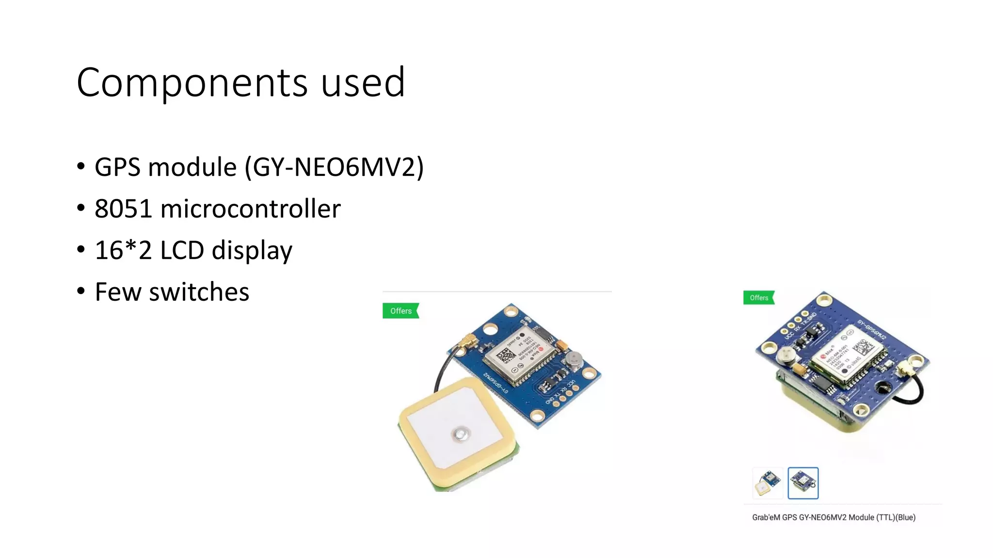
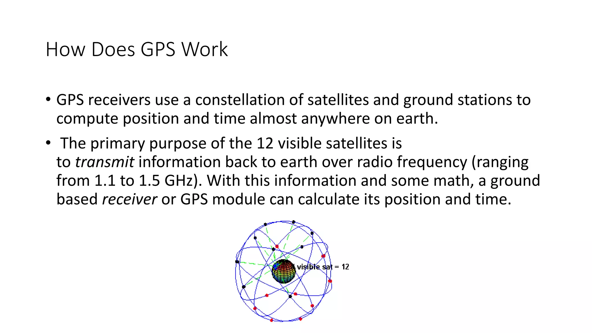
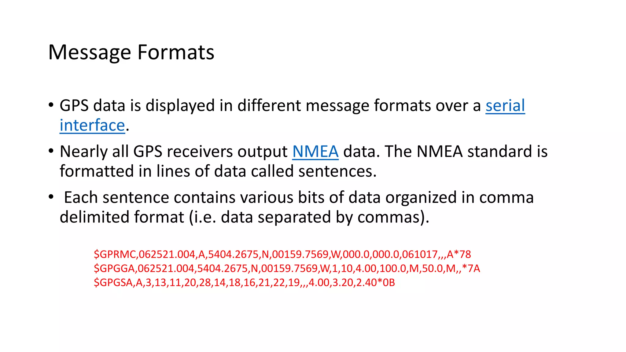
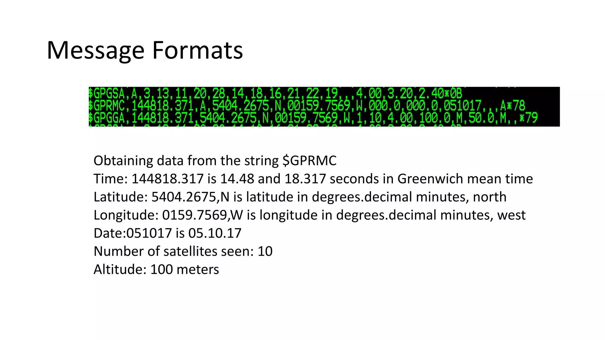
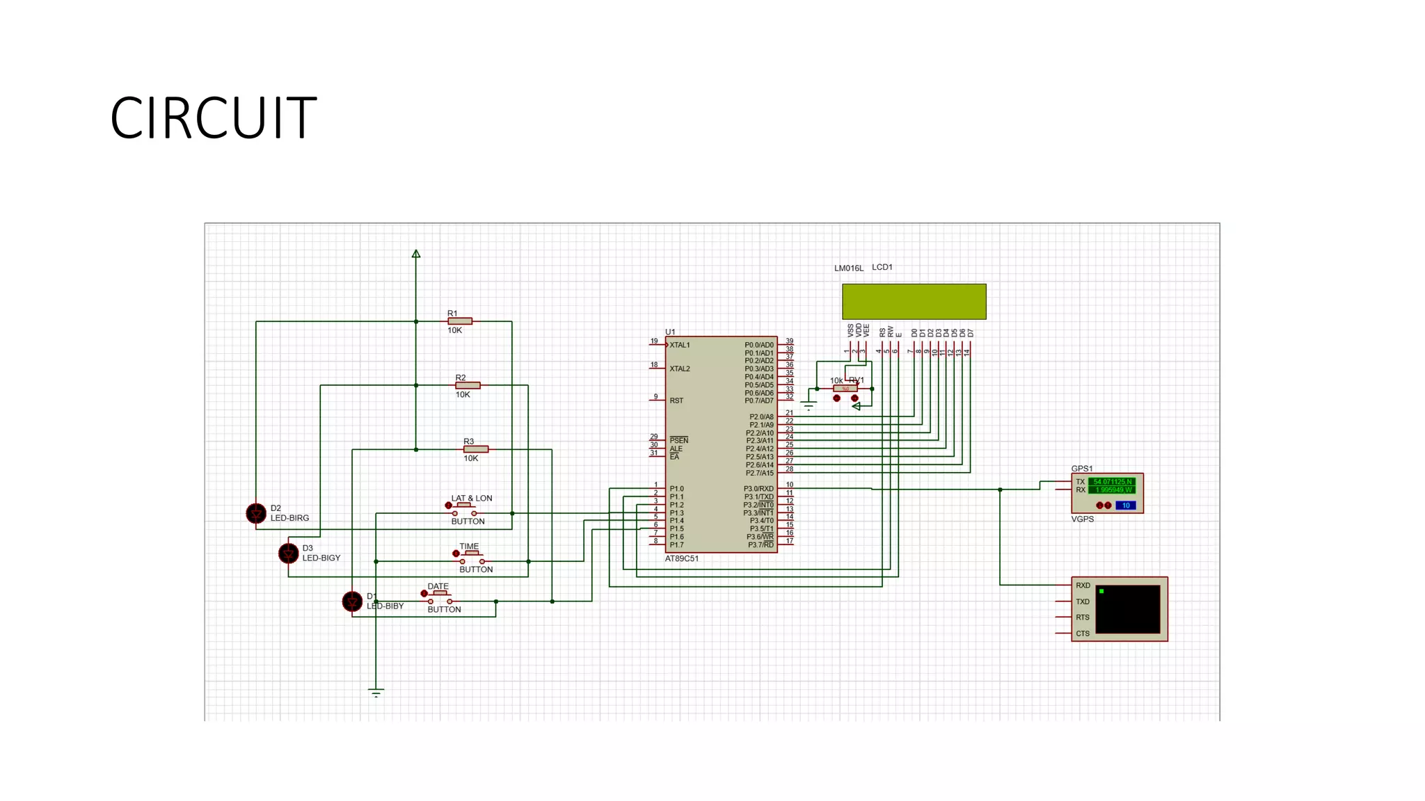
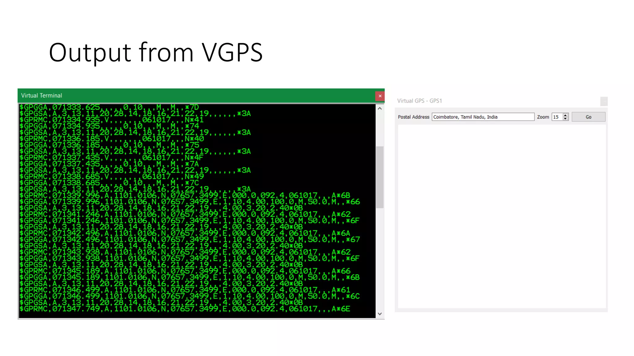
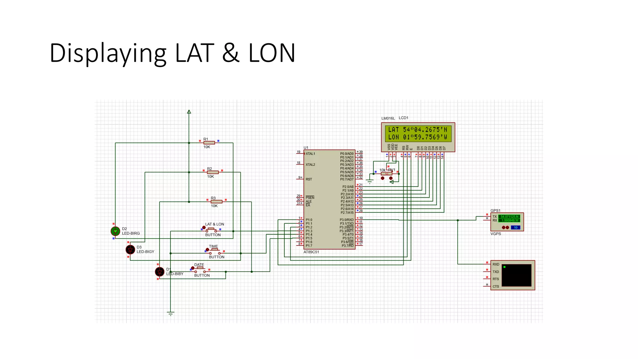
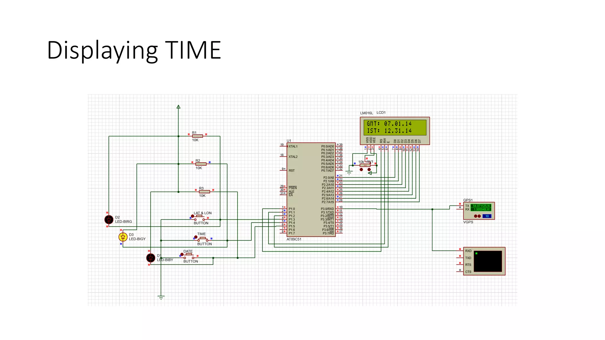
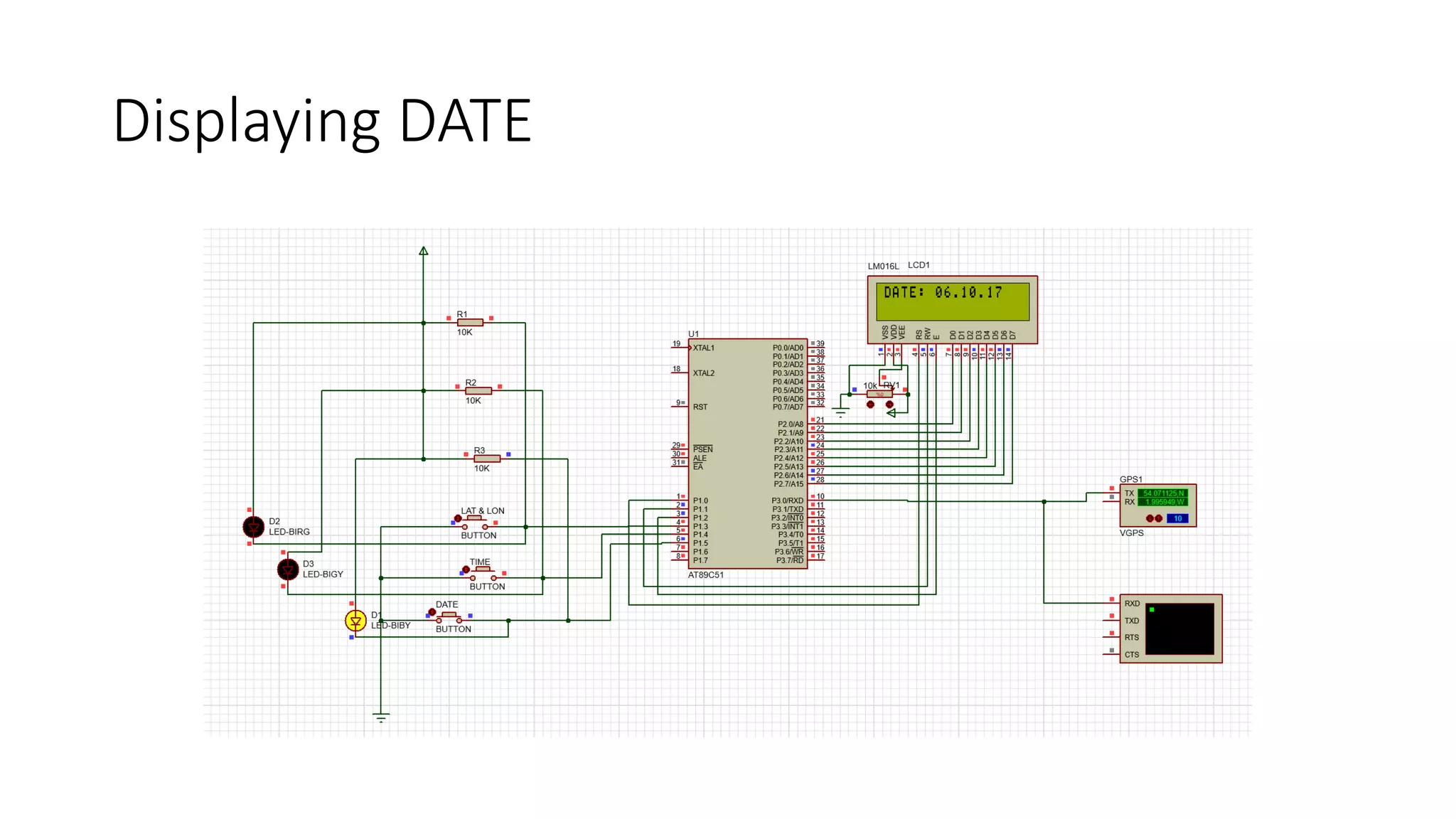
Interfacing GPS with 8051 and displaying the output data in NMEA format from the gps module to 8051 microcontroller and finally displaying the latitude and longitude information also the date and time in a LCD display.
This is used to track the exact location of a vehicle using GPS tracking systems and give information about the position to concerned person through GSM via SMS.
This project is about tracking system that tracks vehicle using gps and gsm/gprs. Also, it displays information for user interface using web and mobile application.Beside that it displays information on lcd as a form of public notice board too.
Navigation System
GPS
Global Positioning System
Founders of Navigation System
Types Of Navigation System
How does navigation system works?
Global Positioning System
Applications
Satellite Link Design:
EIRP, Transmission Losses, Free-space transmission, System noise temperature and G/T ratio, Noise figure, Design of downlinks, Design of uplink, Design of specified C/N: combining C/N and C/I values in satellite links, Overall C/No, Link design procedure.
Gas Leakage Detection Based on IOT
Cloud Technologies providing Complete Solution for all
Academic Projects Final Year/Semester Student Projects
For More Details,
Contact:
Mobile:- +91 8121953811,
whatsapp:- +91 8522991105,
Email ID: cloudtechnologiesprojects@gmail.com
A very small aperture terminal (VSAT) is a small telecommunication earth station that receives and transmits real-time data via satellite.
A VSAT transmits narrow and broadband signals to orbital satellites. The data from the satellites is then transmitted to different hubs in other locations around the globeT.
Application of secondary surveillance RADAR in Identification-friend or foe (IFF) technology. Finds a very important application in defence (military) domain
Understanding GPS & NMEA Messages and Algo to extract Information from NMEA.Robo India
This article is about learning Global Positioning system.
In order to understand GPS, we need to communication protocol of GPS. GPS communicates in NMEA messages.
This document describes NMEA messages and algorithm to extract data.
We welcome all of your queries and views. We are found at-
website- http://roboindia.com
mail-info@roboindia.com
Differential Global Positioning System (DGPS) is an enhancement to Global Positioning System that provides improved location accuracy, from the
15-meter nominal GPS accuracy to about 10 cm in case of the best implementations. Differential Global Positioning System (DGPS) is a method of providing differential corrections to a Global Positioning System (GPS) receiver in order to improve the accuracy of the navigation solution. DGPS corrections originate from a reference station at a known location. The receivers in these reference stations can estimate errors in the GPS because, unlike the general population of GPS receivers, they have an accurate knowledge of their position.
DGPS uses a network of fixed, ground-based reference stations to broadcast the difference between the positions indicated by the GPS (satellite) systems and the known fixed positions. These stations broadcast the difference between the measured satellite pseudoranges and actual (internally computed) pseudoranges, and receiver stations may correct their pseudoranges by the same amount. The digital correction signal is typically broadcast locally over ground-based transmitters of shorter range.
A Global Positioning System (GPS) is a space-based satellite navigation system that provides location and time information in all weather conditions,
but how does it work?
This application, installed in a mobile device, allows the user to survey and stake out topographic data using a broad range of GNSS receivers, integrated or connected through serial cable or Bluetooth. Also it allows user to connect with virtual reference station through GPRS/3G. The program provides many options for traditional surveys and setting out, and for all kind of linear works projects as well.
Design of field programmable gate array-based data processing system for mul...IJECEIAES
A global positioning system (GPS) sensor is needed for a ballistic/moving object to do position tracking. In previous study, a multi GPS processing system was made using several microcontrollers and data processing cannot be done simultaneously. Therefore, it was considered as ineffective system. In this research, field programmable gate array (FPGA)-based data processing system for multi-GPS receiver was proposed. The proposed system was designed to reduce root mean square error (RMSE). There are two main processes in the proposed system which work in parallel, i.e. data parsing and data processing. Raw data from GPS receiver was collected and calculated to get average value, then sent it through serial communication to show result. Experimental results confirm the RMSE value of the proposed system is smaller than the conventional one. The RMSE for latitude, longitude, and altitude decrease by 38.46%, 58.28%, and 24.80%, respectively.
Level sensitive scan design(LSSD) and Boundry scan(BS)Praveen Kumar
This presentation contains,
Introduction,design for testability, scan chain, operation, scan structure, test vectors, Boundry scan, test logic, operation, BS cell, states of TAP controller, Boundry scan instructions.
This ppt describes about,
introduction of fuses, construction, Important terms, advantages and disadvantages, desirable characteristics of fuse element, Current time characteristics, Fuse types - Low voltages fuses and High voltage fuses, Semi enclosed rewirable fuse, HRC cartridge fuses - parts, operation, pros and cons, High voltage fuses and its types, selection of fuses, discrimination
Introduction of SCADA, Architecture of SCADA, Software and hardware architecture, Components of a SCADA system, Functions of SCADA, Alarms and events, alarm logging, comparision between scada and DCS
SPICE LEVEL I/LEVEL II/LEVEL III AND BSIM MODELSPraveen Kumar
SPICE LEVEL I/LEVEL II/LEVEL III AND BSIM MODELS
SPICE introduction
working
adaptions
detailed discussion on each models
SPICE Modeling in BSIM
features
bulk voltage on large signal model
velocity saturation
weak inversion operation
impact ionization
Finite word length of IIR filters Limit cycles due to product round-off error...Praveen Kumar
Finite word length of IIR filters Limit cycles due to product round-off errors and other non-linear characteristics
Limit cycles due to round-off errors
infinite precision
round off
truncation
An Example
MATLAB Codes
Inference
Other non-linear Characteristics
Jump Phenomenon
Subharmonic Response
Effects of product round-off errors
SOLAR POWER generation using solar PV and Concentrated solar power technologyPraveen Kumar
Concentrated Solar Power Technology
Power Tower Systems
Parabolic Trough Systems
Solar Dish Systems
Compact Linear Fresnel
Types, working, pros &cons
Scope in INDIA
Using Photo-Voltaic cells
-Working of PV Cells
-Considering different PV materials
-Efficiency, Comparing modules manufactured by different companies
-MPPT
- algorithms
-A view of different inverter topologies used
pyrheliometer
SELECTION OF DRIVES AND CONTROL SCHEMES FOR MACHINE TOOLS Praveen Kumar
SELECTION OF DRIVES AND CONTROL SCHEMES FOR MACHINE TOOLS
Machine tools and drives
Horse power requirement for driving the machine tools
MOTOR REQUIREMENTS FOR MACHINE TOOLS.
SELECTION OF MOTORS
Speed control of Drill press
Application of Motors to Planers, Shapers
Reversible motor drive quick return mechanism
GRINDING MACHINES
VFD
Sorting
Performance parameters
Insertion Sort
Technique
Algorithm
Performance with examples
Applications
Example Program
Shell Sort
Technique
Algorithm
Performance with examples
Applications
Example Program
Vehicle safety system
it covers
hydraulic brakes
working of drum ,disk brakes
abs
airbags
ESP/ESC(electronic stability programme)
future trends in safety systems
cruise control
ACC
introduction, types & structure of MOSET ,turn ON and OFF of device, working, I-V characteristics of MOSFET,Different regions of operations,applications, adv & disadvantages
REVERSE POWER RELAY for solar PV systemsPraveen Kumar
this presentation gives an idea about designing a device using microcontroller that detects the reverse power flow from solar pannels to the grid when the load is less.
Digital Voltmeter, Digital Ammeter and Digital MultimeterPraveen Kumar
This ppt deals with Digital meters,the digital components used in them,principle behind the working of Digital Voltmeter(DC) Digital Voltmeter(AC) and mechanism of Measurement of Current and Measurement of Resistance. Finally A complete DMM also the Measurement of hfe. A small project on constructing digital voltmeter and ohmmeter using Arduino.
NO MICROCONTROLLER is used in making of these autonomous robot, we have just used only the operational amplifier as a controller and achieved the bot.we have made 2 bots Line follower and light follower with simulations in proteus and hardware implementation of these bots. Also made a wireless light controlled bot using the same concepts.Hope this presentation will be much helpful for your mini projects. Do leave some comments. Thank u.
Ventilating systems for electrical machinesPraveen Kumar
this presentation is about types of ventilation given to the electrical machines,an analysis for the best type,future improvements,and their importance in electrical machines
CFD Simulation of By-pass Flow in a HRSG module by R&R Consult.pptxR&R Consult
CFD analysis is incredibly effective at solving mysteries and improving the performance of complex systems!
Here's a great example: At a large natural gas-fired power plant, where they use waste heat to generate steam and energy, they were puzzled that their boiler wasn't producing as much steam as expected.
R&R and Tetra Engineering Group Inc. were asked to solve the issue with reduced steam production.
An inspection had shown that a significant amount of hot flue gas was bypassing the boiler tubes, where the heat was supposed to be transferred.
R&R Consult conducted a CFD analysis, which revealed that 6.3% of the flue gas was bypassing the boiler tubes without transferring heat. The analysis also showed that the flue gas was instead being directed along the sides of the boiler and between the modules that were supposed to capture the heat. This was the cause of the reduced performance.
Based on our results, Tetra Engineering installed covering plates to reduce the bypass flow. This improved the boiler's performance and increased electricity production.
It is always satisfying when we can help solve complex challenges like this. Do your systems also need a check-up or optimization? Give us a call!
Work done in cooperation with James Malloy and David Moelling from Tetra Engineering.
More examples of our work https://www.r-r-consult.dk/en/cases-en/
Cosmetic shop management system project report.pdfKamal Acharya
Buying new cosmetic products is difficult. It can even be scary for those who have sensitive skin and are prone to skin trouble. The information needed to alleviate this problem is on the back of each product, but it's thought to interpret those ingredient lists unless you have a background in chemistry.
Instead of buying and hoping for the best, we can use data science to help us predict which products may be good fits for us. It includes various function programs to do the above mentioned tasks.
Data file handling has been effectively used in the program.
The automated cosmetic shop management system should deal with the automation of general workflow and administration process of the shop. The main processes of the system focus on customer's request where the system is able to search the most appropriate products and deliver it to the customers. It should help the employees to quickly identify the list of cosmetic product that have reached the minimum quantity and also keep a track of expired date for each cosmetic product. It should help the employees to find the rack number in which the product is placed.It is also Faster and more efficient way.
Hybrid optimization of pumped hydro system and solar- Engr. Abdul-Azeez.pdffxintegritypublishin
Advancements in technology unveil a myriad of electrical and electronic breakthroughs geared towards efficiently harnessing limited resources to meet human energy demands. The optimization of hybrid solar PV panels and pumped hydro energy supply systems plays a pivotal role in utilizing natural resources effectively. This initiative not only benefits humanity but also fosters environmental sustainability. The study investigated the design optimization of these hybrid systems, focusing on understanding solar radiation patterns, identifying geographical influences on solar radiation, formulating a mathematical model for system optimization, and determining the optimal configuration of PV panels and pumped hydro storage. Through a comparative analysis approach and eight weeks of data collection, the study addressed key research questions related to solar radiation patterns and optimal system design. The findings highlighted regions with heightened solar radiation levels, showcasing substantial potential for power generation and emphasizing the system's efficiency. Optimizing system design significantly boosted power generation, promoted renewable energy utilization, and enhanced energy storage capacity. The study underscored the benefits of optimizing hybrid solar PV panels and pumped hydro energy supply systems for sustainable energy usage. Optimizing the design of solar PV panels and pumped hydro energy supply systems as examined across diverse climatic conditions in a developing country, not only enhances power generation but also improves the integration of renewable energy sources and boosts energy storage capacities, particularly beneficial for less economically prosperous regions. Additionally, the study provides valuable insights for advancing energy research in economically viable areas. Recommendations included conducting site-specific assessments, utilizing advanced modeling tools, implementing regular maintenance protocols, and enhancing communication among system components.
Sachpazis:Terzaghi Bearing Capacity Estimation in simple terms with Calculati...Dr.Costas Sachpazis
Terzaghi's soil bearing capacity theory, developed by Karl Terzaghi, is a fundamental principle in geotechnical engineering used to determine the bearing capacity of shallow foundations. This theory provides a method to calculate the ultimate bearing capacity of soil, which is the maximum load per unit area that the soil can support without undergoing shear failure. The Calculation HTML Code included.
NO1 Uk best vashikaran specialist in delhi vashikaran baba near me online vas...Amil Baba Dawood bangali
Contact with Dawood Bhai Just call on +92322-6382012 and we'll help you. We'll solve all your problems within 12 to 24 hours and with 101% guarantee and with astrology systematic. If you want to take any personal or professional advice then also you can call us on +92322-6382012 , ONLINE LOVE PROBLEM & Other all types of Daily Life Problem's.Then CALL or WHATSAPP us on +92322-6382012 and Get all these problems solutions here by Amil Baba DAWOOD BANGALI
#vashikaranspecialist #astrologer #palmistry #amliyaat #taweez #manpasandshadi #horoscope #spiritual #lovelife #lovespell #marriagespell#aamilbabainpakistan #amilbabainkarachi #powerfullblackmagicspell #kalajadumantarspecialist #realamilbaba #AmilbabainPakistan #astrologerincanada #astrologerindubai #lovespellsmaster #kalajaduspecialist #lovespellsthatwork #aamilbabainlahore#blackmagicformarriage #aamilbaba #kalajadu #kalailam #taweez #wazifaexpert #jadumantar #vashikaranspecialist #astrologer #palmistry #amliyaat #taweez #manpasandshadi #horoscope #spiritual #lovelife #lovespell #marriagespell#aamilbabainpakistan #amilbabainkarachi #powerfullblackmagicspell #kalajadumantarspecialist #realamilbaba #AmilbabainPakistan #astrologerincanada #astrologerindubai #lovespellsmaster #kalajaduspecialist #lovespellsthatwork #aamilbabainlahore #blackmagicforlove #blackmagicformarriage #aamilbaba #kalajadu #kalailam #taweez #wazifaexpert #jadumantar #vashikaranspecialist #astrologer #palmistry #amliyaat #taweez #manpasandshadi #horoscope #spiritual #lovelife #lovespell #marriagespell#aamilbabainpakistan #amilbabainkarachi #powerfullblackmagicspell #kalajadumantarspecialist #realamilbaba #AmilbabainPakistan #astrologerincanada #astrologerindubai #lovespellsmaster #kalajaduspecialist #lovespellsthatwork #aamilbabainlahore #Amilbabainuk #amilbabainspain #amilbabaindubai #Amilbabainnorway #amilbabainkrachi #amilbabainlahore #amilbabaingujranwalan #amilbabainislamabad
2. Objective of this project
• The Latitude and longitude values are extracted from the data in
NMEA format the GPS module and display it in the LCD display.
• To extract time information and convert it to IST format and display it
in the LCD.
• To extract date information and display it in the LCD.
3. Components used
• GPS module (GY-NEO6MV2)
• 8051 microcontroller
• 16*2 LCD display
• Few switches
4. How Does GPS Work
• GPS receivers use a constellation of satellites and ground stations to
compute position and time almost anywhere on earth.
• The primary purpose of the 12 visible satellites is
to transmit information back to earth over radio frequency (ranging
from 1.1 to 1.5 GHz). With this information and some math, a ground
based receiver or GPS module can calculate its position and time.
5. Working
• . If the GPS receiver’s antenna can see at least 4 satellites, it can
accurately calculate its position and time. This is also called a lock or
a fix.
• To configure a GPS receiver, knowing the type of chipset your GPS is
using is very important. The GPS chipset contains a powerful
processor that is responsible for the user interface, all of the
calculations, as well as analog circuitry for the antenna.
• The chipset also allows for data to be sent to the GPS receiver to
configure parameters like, update rate, baud rate, sentence selection,
etc.
6. Message Formats
• GPS data is displayed in different message formats over a serial
interface.
• Nearly all GPS receivers output NMEA data. The NMEA standard is
formatted in lines of data called sentences.
• Each sentence contains various bits of data organized in comma
delimited format (i.e. data separated by commas).
$GPRMC,062521.004,A,5404.2675,N,00159.7569,W,000.0,000.0,061017,,,A*78
$GPGGA,062521.004,5404.2675,N,00159.7569,W,1,10,4.00,100.0,M,50.0,M,,*7A
$GPGSA,A,3,13,11,20,28,14,18,16,21,22,19,,,4.00,3.20,2.40*0B
7. Extraction of Latitude and Longitude values
from NMEA Format
• The first received 6 characters from GPS module are compared with string
$GPRMC, if matched then will go for further process otherwise repeat the
same process again.
• If string is matched then wait till you will get two 2 commas, next character
indicates weather the GPS is activated or not.
• If this character is A then GPS is activated otherwise GPS is not activated.
Now again wait till you get comma (,).
• The next 9 characters indicate the LATITUDE. Wait till you get 2 more
commas (,) the next 10 characters indicates the LONGITUDE.
• This data is sent out on the serial port at an interval called the update rate.
8. Message Formats
Obtaining data from the string $GPRMC
Time: 144818.317 is 14.48 and 18.317 seconds in Greenwich mean time
Latitude: 5404.2675,N is latitude in degrees.decimal minutes, north
Longitude: 0159.7569,W is longitude in degrees.decimal minutes, west
Date:051017 is 05.10.17
Number of satellites seen: 10
Altitude: 100 meters
14. Circuit Applications:
• Used in tracking devices and mapping devices
• Used in personal positioning
• Date and time monitoring
• This project is used in embedded system applications to find
out the location.
• VR games.