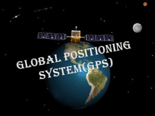
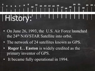
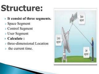
What’s it?
• It is a Space based satellite
navigation system.
• Provides : location and time
information in all weather
conditions.
• Maintained by the United
States government
• Accessible to anyone with a GPS
Receiver.
History:
• On June 26, 1993, the U.S. Air Force launched
the 24th NAVSTAR Satellite into orbit.
• The network of 24 satellites known as GPS.
• Roger L . Easton is widely credited as the
primary inventor of GPS.
• It became fully operational in 1994.
Types of GPS:
• They vary according to our need.
Major types:
• GPS Navigators
• Hand-held GPS
• GPS Trackers
• Emergency GPS
 It consist of three segments.
 Space Segment
 Control Segment
 User Segment
 Calculate :
 three-dimensional Location
 the current time.
Segment description:
• Space segment:
Composed of satellites.
Constellation refers to “set of satellites”
NAVSTAR composed of 24 satellites.
Function : Transmit signal from space on the basis
of which the time and position of the user is
measured.
• Control Segment:
Holds:
 5 ground based monitor station
 3 antennas
 a master control station
Function:
Monitor station  master controller
Antenna  GPS receiver
User Segment:
• Holds:
GPS Receiver
User community
• Function:
Converts SV Signals into
Position ,
time,
velocity.
Working:
Basically working holds three task as follows:
• The GPS transmits signals from the satellites
down to earth.
• GPS Receiver then analyzes the data that was
received.
• Then uses the mathematical concept of
triangulation to compute the exact location of
the user.
Accuracy:
It depends upon the types of receiver.
Most hand-held GPS units have about 10-20 meter
accuracy.
Differential GPS (DGPS) obtains much higher
accuracy.
As recorded by the roving units, producing an
accuracy greater than 1 meter.
Advantages:
Easy to navigate
GPS works in all weather.
100% coverage on the planet.
Easy to integrate into other technologies like Cell
phone.
Best navigating system in water.
Disadvantage:
GPS signals are not accurate due to some obstacles to
the signals.
Atmospheric conditions such as geomagnetic storms
makes it not accurate.
If GPS on a battery operated device, there may be a
battery failure we need an external power supply
which is not always possible
GPS Application:
• Google Earth is the most famous application that
uses the signals received by the GPS receivers.
• United States and European countries show a rapid
growth in using GPS for the car navigations and the
number of GPS equipped mobile phone usage.
Some Application:
• DeLorme Street Atlas 2010
• Gramin nRoute
• Top Grossing Apps on iTunes
• LOCiMOBILE Apps for tracking people
• GPS Tracking Lite v2.0
Recent Development:
Block IIA:
– upgraded version of the GPS Block II satellites.
– Developed by Rockwell International
– As of November 2012, there were 9 Block IIA
satellites.
GPS Block IIR:
-"R" in Block IIR stands for replenishment.
-Developed by Lockheed Martin
-As of November 2012, there were 12 IIR
satellites
Current development:
GPS Block III:
• development by Lockheed Martin
• GPS III will provide more powerful signals in
addition to enhanced signal reliability, accuracy,
and integrity.
• GPS III series is the newest block of GPS satellites
Future of GPS:
The future will hold a lot more surprises.
Automobiles are tested on moving on their own without
the assistance of a driver.
Tests have begun in using unmanned aircrafts.
The green plant density of a certain area can be
calculated or estimated.
Conclusion:
• GPS has truly helped man to advance in more ways
than one.
• It is also going to bring a great revolution by its
development.
Presented by,
I.Madhumithah, I M.Sc(CS).,
G.Venkataswamy Naidu College,
Kovilpatti.

Gps

  • 2.
    What’s it? • Itis a Space based satellite navigation system. • Provides : location and time information in all weather conditions. • Maintained by the United States government • Accessible to anyone with a GPS Receiver.
  • 3.
    History: • On June26, 1993, the U.S. Air Force launched the 24th NAVSTAR Satellite into orbit. • The network of 24 satellites known as GPS. • Roger L . Easton is widely credited as the primary inventor of GPS. • It became fully operational in 1994.
  • 4.
    Types of GPS: •They vary according to our need. Major types: • GPS Navigators • Hand-held GPS • GPS Trackers • Emergency GPS
  • 5.
     It consistof three segments.  Space Segment  Control Segment  User Segment  Calculate :  three-dimensional Location  the current time.
  • 6.
    Segment description: • Spacesegment: Composed of satellites. Constellation refers to “set of satellites” NAVSTAR composed of 24 satellites. Function : Transmit signal from space on the basis of which the time and position of the user is measured.
  • 7.
    • Control Segment: Holds: 5 ground based monitor station  3 antennas  a master control station Function: Monitor station  master controller Antenna  GPS receiver
  • 8.
    User Segment: • Holds: GPSReceiver User community • Function: Converts SV Signals into Position , time, velocity.
  • 9.
    Working: Basically working holdsthree task as follows: • The GPS transmits signals from the satellites down to earth. • GPS Receiver then analyzes the data that was received. • Then uses the mathematical concept of triangulation to compute the exact location of the user.
  • 10.
    Accuracy: It depends uponthe types of receiver. Most hand-held GPS units have about 10-20 meter accuracy. Differential GPS (DGPS) obtains much higher accuracy. As recorded by the roving units, producing an accuracy greater than 1 meter.
  • 11.
    Advantages: Easy to navigate GPSworks in all weather. 100% coverage on the planet. Easy to integrate into other technologies like Cell phone. Best navigating system in water.
  • 12.
    Disadvantage: GPS signals arenot accurate due to some obstacles to the signals. Atmospheric conditions such as geomagnetic storms makes it not accurate. If GPS on a battery operated device, there may be a battery failure we need an external power supply which is not always possible
  • 13.
    GPS Application: • GoogleEarth is the most famous application that uses the signals received by the GPS receivers. • United States and European countries show a rapid growth in using GPS for the car navigations and the number of GPS equipped mobile phone usage.
  • 14.
    Some Application: • DeLormeStreet Atlas 2010 • Gramin nRoute • Top Grossing Apps on iTunes • LOCiMOBILE Apps for tracking people • GPS Tracking Lite v2.0
  • 15.
    Recent Development: Block IIA: –upgraded version of the GPS Block II satellites. – Developed by Rockwell International – As of November 2012, there were 9 Block IIA satellites. GPS Block IIR: -"R" in Block IIR stands for replenishment. -Developed by Lockheed Martin -As of November 2012, there were 12 IIR satellites
  • 16.
    Current development: GPS BlockIII: • development by Lockheed Martin • GPS III will provide more powerful signals in addition to enhanced signal reliability, accuracy, and integrity. • GPS III series is the newest block of GPS satellites
  • 17.
    Future of GPS: Thefuture will hold a lot more surprises. Automobiles are tested on moving on their own without the assistance of a driver. Tests have begun in using unmanned aircrafts. The green plant density of a certain area can be calculated or estimated.
  • 19.
    Conclusion: • GPS hastruly helped man to advance in more ways than one. • It is also going to bring a great revolution by its development.
  • 20.
    Presented by, I.Madhumithah, IM.Sc(CS)., G.Venkataswamy Naidu College, Kovilpatti.