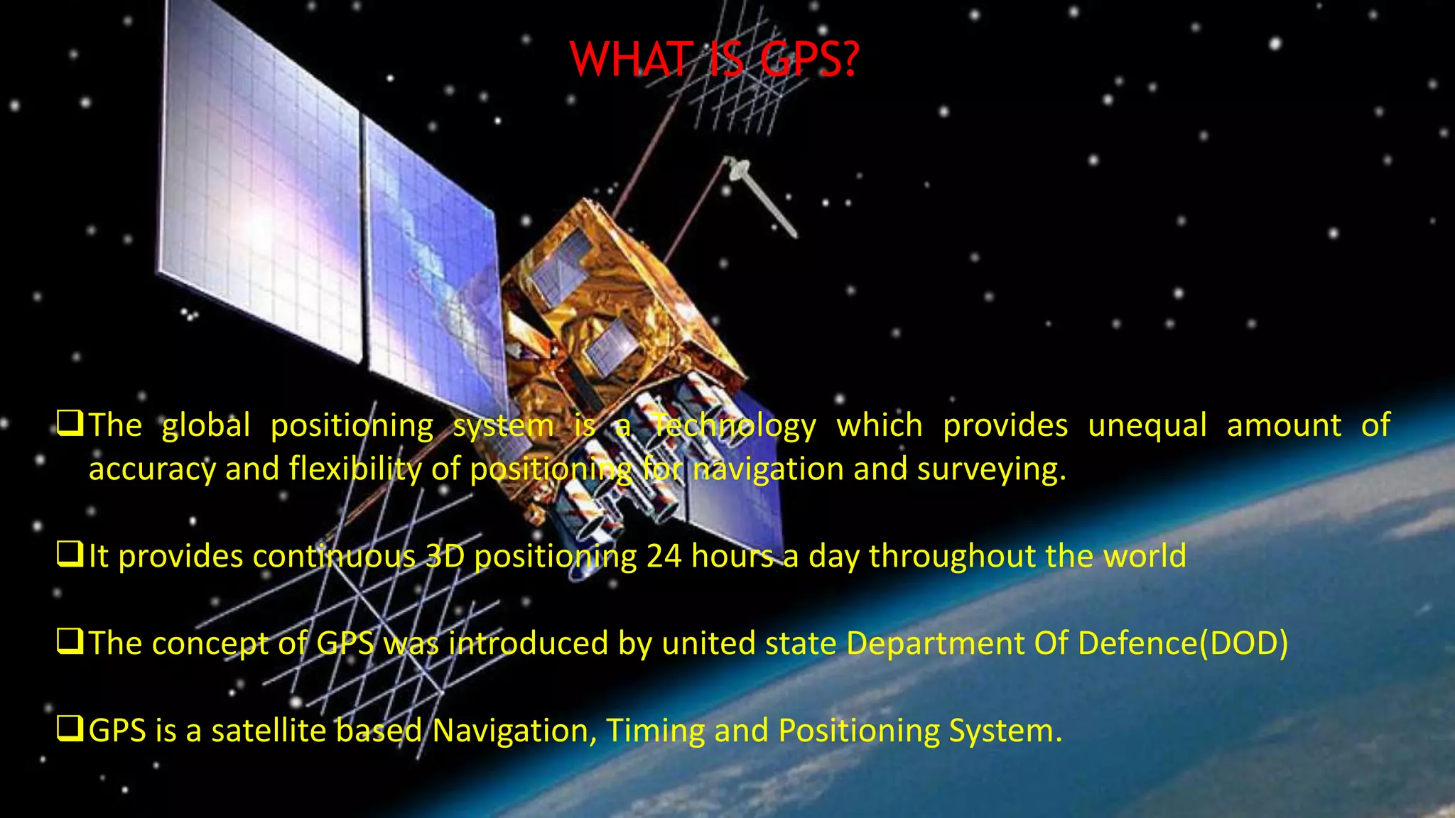
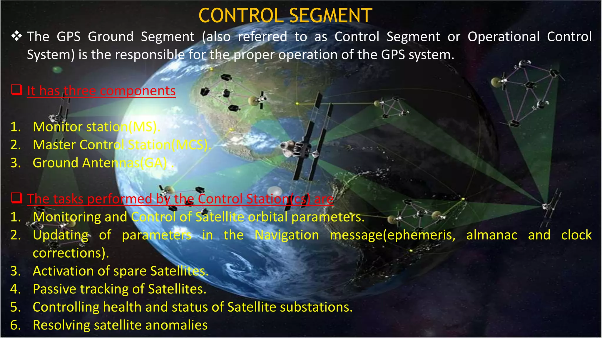
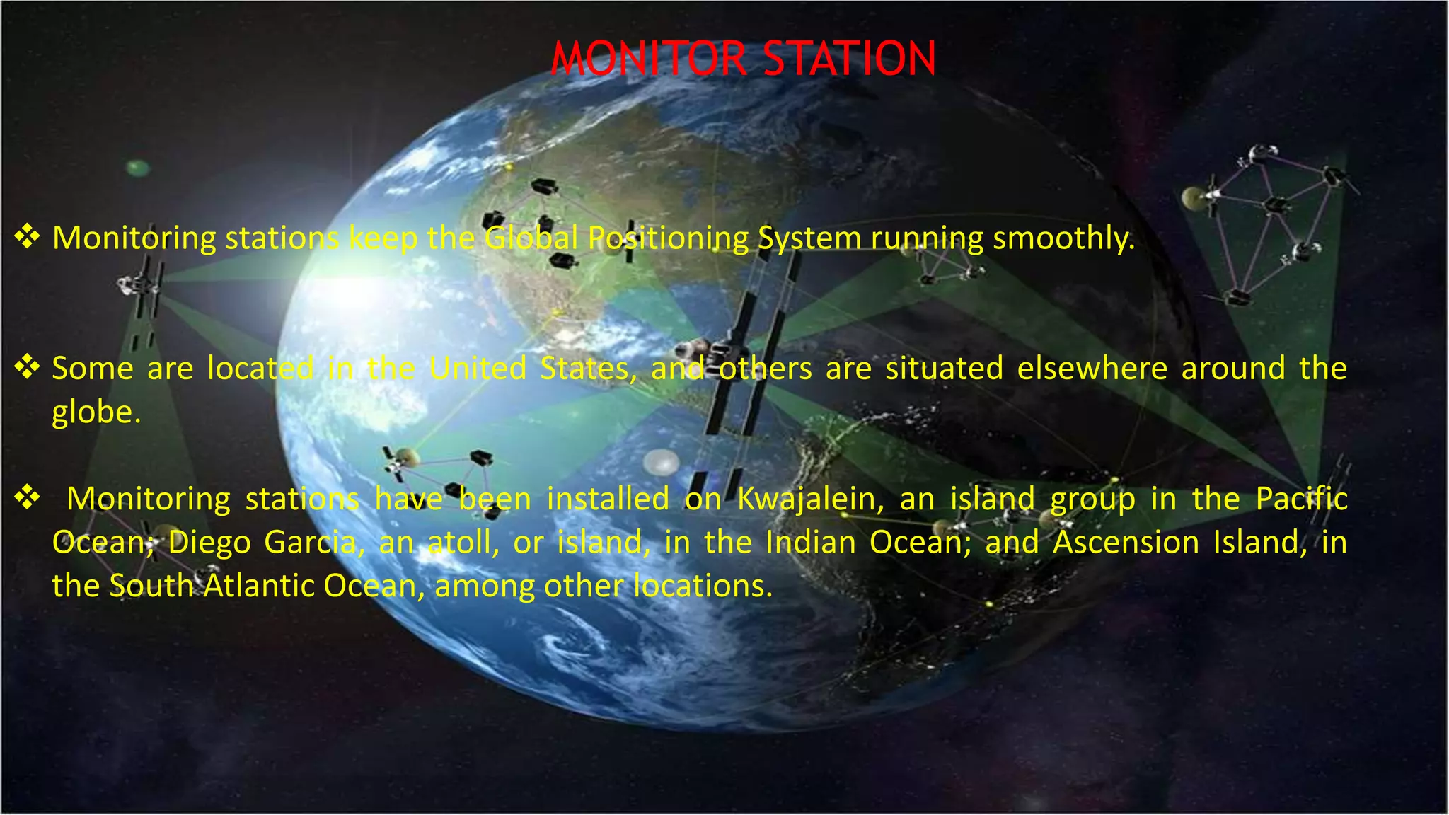
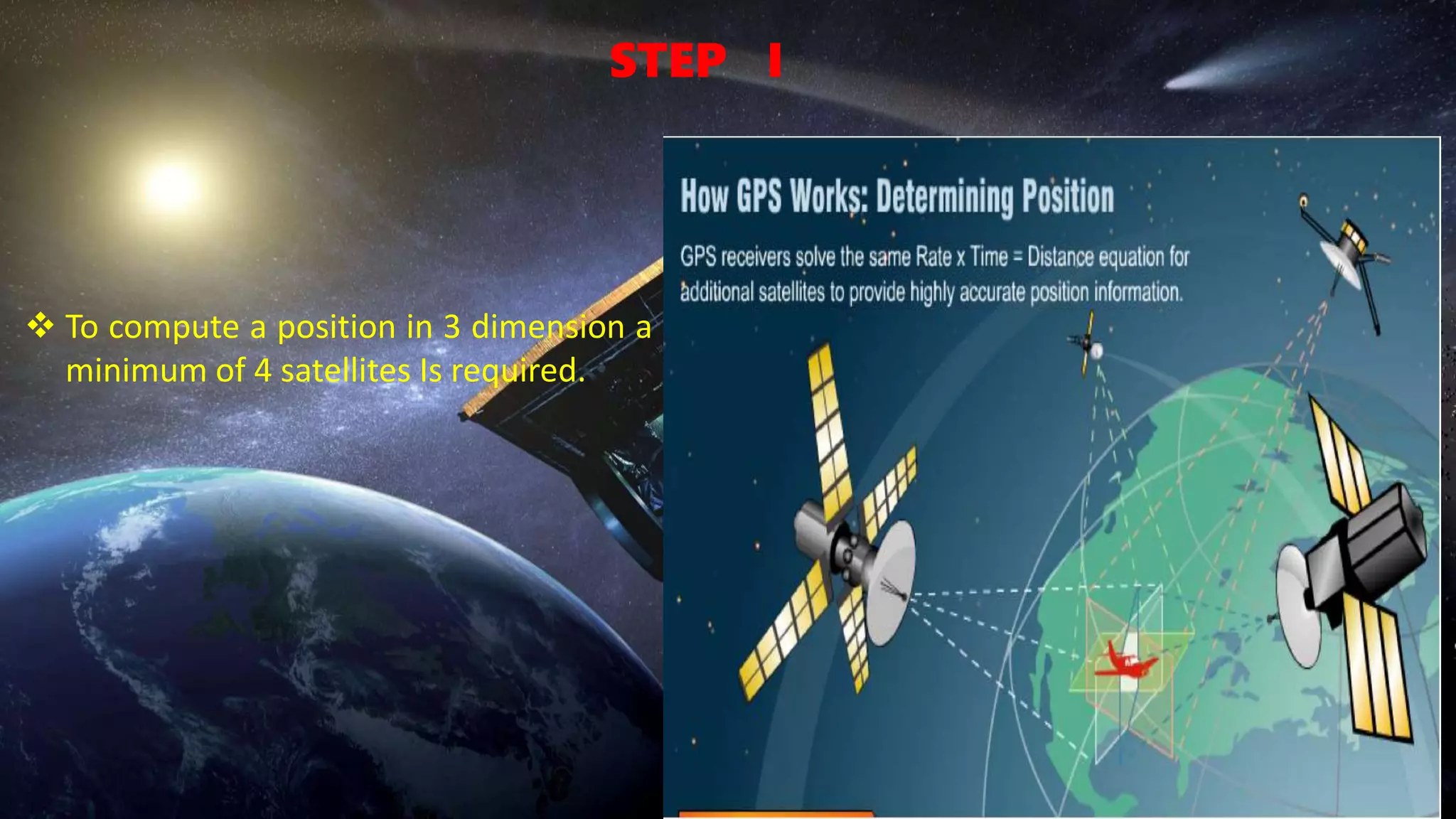
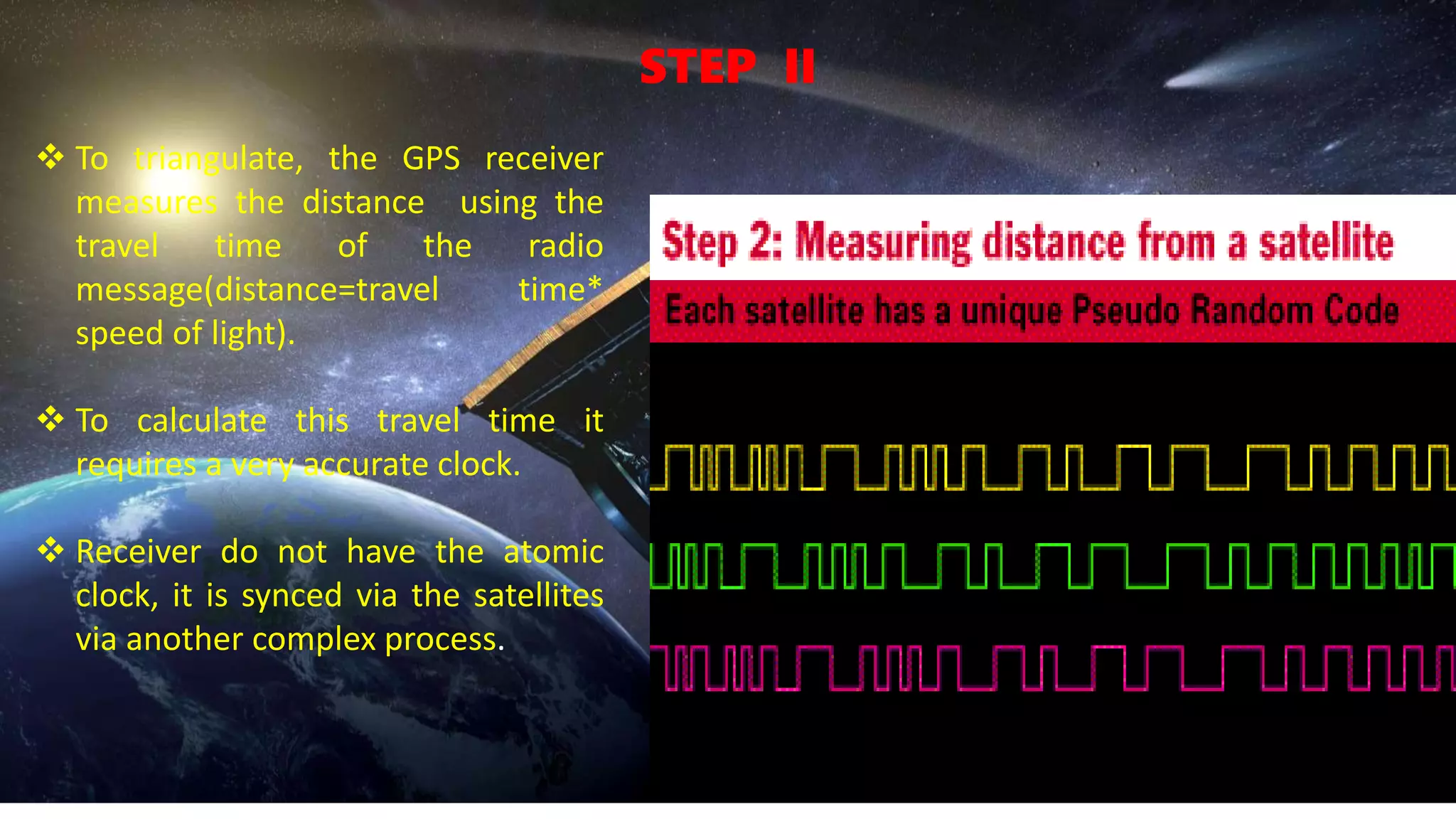
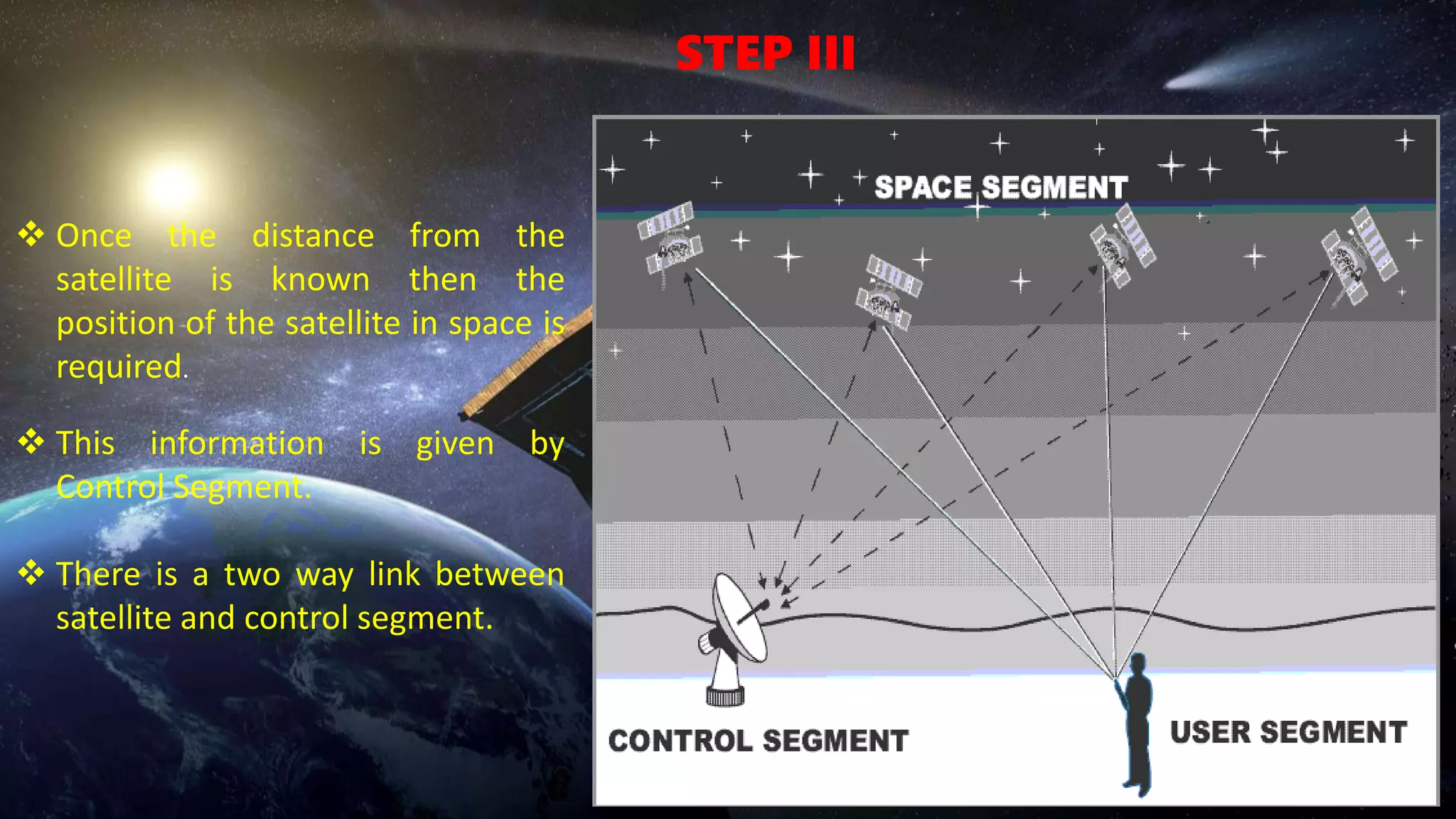
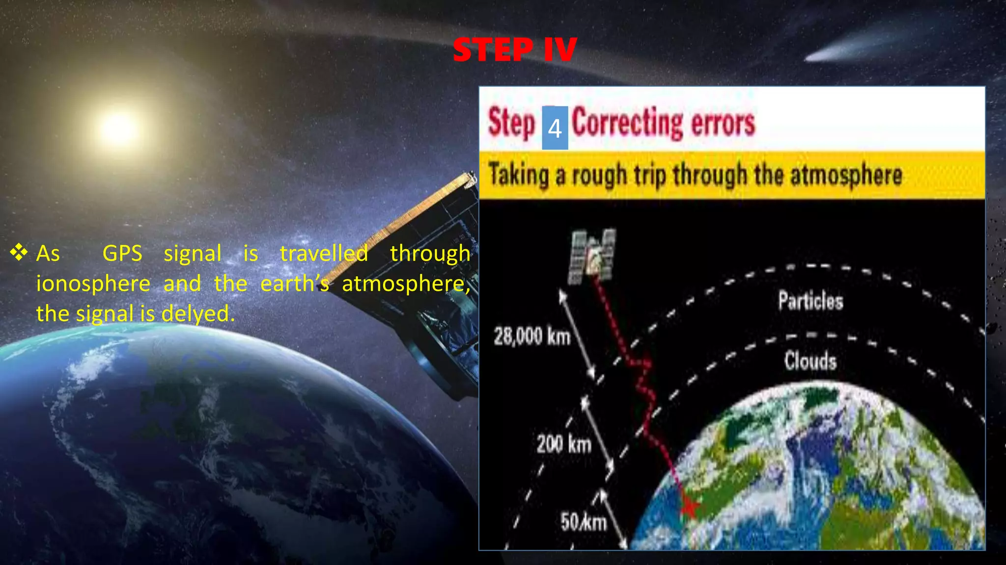
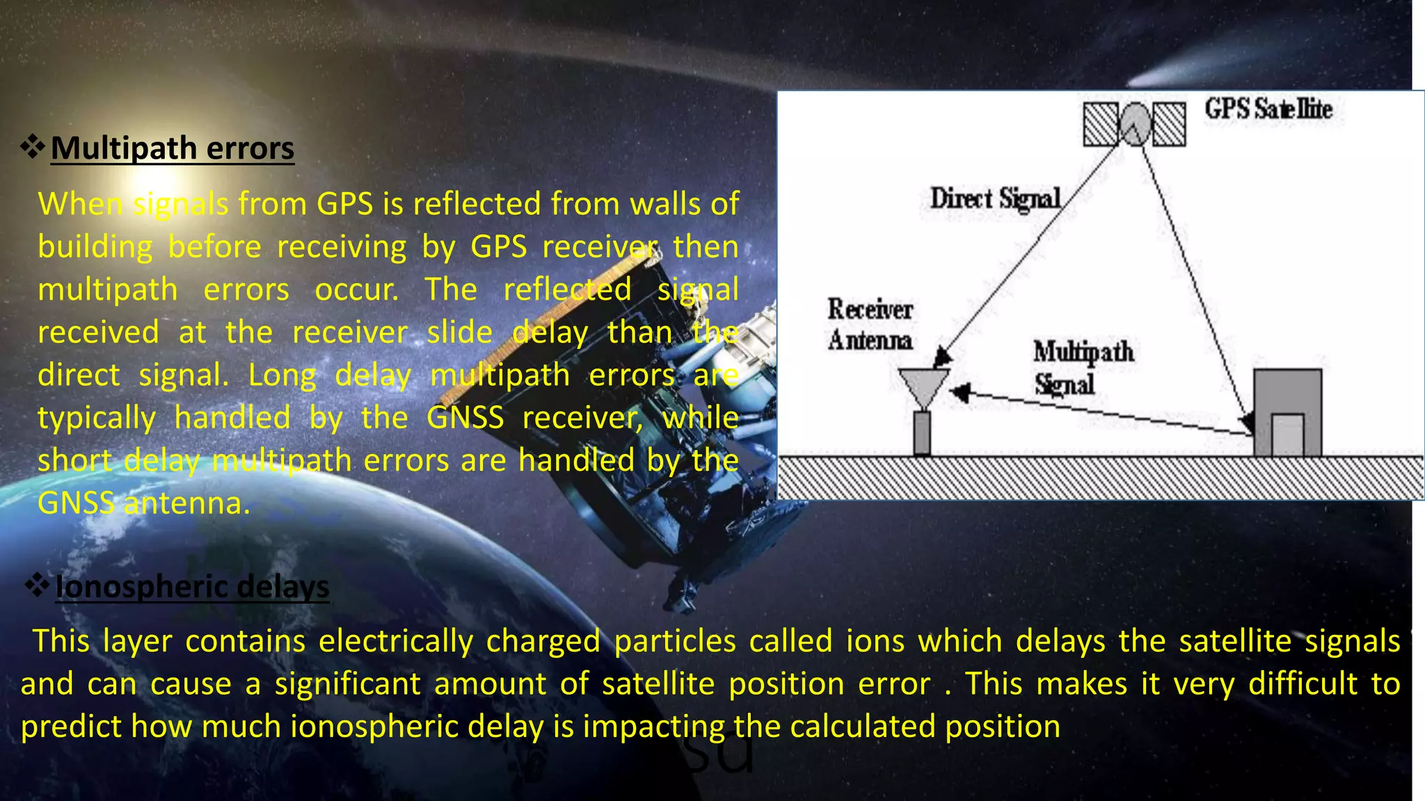
The Global Positioning System (GPS) is a satellite-based navigation system that can be used to locate positions anywhere on earth made up of a network of 24 satellites placed into orbit
Global positioning system and its mathematical form.
By Mustahsan Khan _ BS(physics-Nanotechnology) (International Islamic University Islamabad) Pakistan.
Kubernetes & AI - Beauty and the Beast !?! @KCD Istanbul 2024Tobias Schneck
As AI technology is pushing into IT I was wondering myself, as an “infrastructure container kubernetes guy”, how get this fancy AI technology get managed from an infrastructure operational view? Is it possible to apply our lovely cloud native principals as well? What benefit’s both technologies could bring to each other?
Let me take this questions and provide you a short journey through existing deployment models and use cases for AI software. On practical examples, we discuss what cloud/on-premise strategy we may need for applying it to our own infrastructure to get it to work from an enterprise perspective. I want to give an overview about infrastructure requirements and technologies, what could be beneficial or limiting your AI use cases in an enterprise environment. An interactive Demo will give you some insides, what approaches I got already working for real.
Dev Dives: Train smarter, not harder – active learning and UiPath LLMs for do...UiPathCommunity
💥 Speed, accuracy, and scaling – discover the superpowers of GenAI in action with UiPath Document Understanding and Communications Mining™:
See how to accelerate model training and optimize model performance with active learning
Learn about the latest enhancements to out-of-the-box document processing – with little to no training required
Get an exclusive demo of the new family of UiPath LLMs – GenAI models specialized for processing different types of documents and messages
This is a hands-on session specifically designed for automation developers and AI enthusiasts seeking to enhance their knowledge in leveraging the latest intelligent document processing capabilities offered by UiPath.
Speakers:
👨🏫 Andras Palfi, Senior Product Manager, UiPath
👩🏫 Lenka Dulovicova, Product Program Manager, UiPath
Epistemic Interaction - tuning interfaces to provide information for AI supportAlan Dix
Paper presented at SYNERGY workshop at AVI 2024, Genoa, Italy. 3rd June 2024
https://alandix.com/academic/papers/synergy2024-epistemic/
As machine learning integrates deeper into human-computer interactions, the concept of epistemic interaction emerges, aiming to refine these interactions to enhance system adaptability. This approach encourages minor, intentional adjustments in user behaviour to enrich the data available for system learning. This paper introduces epistemic interaction within the context of human-system communication, illustrating how deliberate interaction design can improve system understanding and adaptation. Through concrete examples, we demonstrate the potential of epistemic interaction to significantly advance human-computer interaction by leveraging intuitive human communication strategies to inform system design and functionality, offering a novel pathway for enriching user-system engagements.
Smart TV Buyer Insights Survey 2024 by 91mobiles.pdf91mobiles
91mobiles recently conducted a Smart TV Buyer Insights Survey in which we asked over 3,000 respondents about the TV they own, aspects they look at on a new TV, and their TV buying preferences.
Let's dive deeper into the world of ODC! Ricardo Alves (OutSystems) will join us to tell all about the new Data Fabric. After that, Sezen de Bruijn (OutSystems) will get into the details on how to best design a sturdy architecture within ODC.
Connector Corner: Automate dynamic content and events by pushing a buttonDianaGray10
Here is something new! In our next Connector Corner webinar, we will demonstrate how you can use a single workflow to:
Create a campaign using Mailchimp with merge tags/fields
Send an interactive Slack channel message (using buttons)
Have the message received by managers and peers along with a test email for review
But there’s more:
In a second workflow supporting the same use case, you’ll see:
Your campaign sent to target colleagues for approval
If the “Approve” button is clicked, a Jira/Zendesk ticket is created for the marketing design team
But—if the “Reject” button is pushed, colleagues will be alerted via Slack message
Join us to learn more about this new, human-in-the-loop capability, brought to you by Integration Service connectors.
And...
Speakers:
Akshay Agnihotri, Product Manager
Charlie Greenberg, Host
LF Energy Webinar: Electrical Grid Modelling and Simulation Through PowSyBl -...DanBrown980551
Do you want to learn how to model and simulate an electrical network from scratch in under an hour?
Then welcome to this PowSyBl workshop, hosted by Rte, the French Transmission System Operator (TSO)!
During the webinar, you will discover the PowSyBl ecosystem as well as handle and study an electrical network through an interactive Python notebook.
PowSyBl is an open source project hosted by LF Energy, which offers a comprehensive set of features for electrical grid modelling and simulation. Among other advanced features, PowSyBl provides:
- A fully editable and extendable library for grid component modelling;
- Visualization tools to display your network;
- Grid simulation tools, such as power flows, security analyses (with or without remedial actions) and sensitivity analyses;
The framework is mostly written in Java, with a Python binding so that Python developers can access PowSyBl functionalities as well.
What you will learn during the webinar:
- For beginners: discover PowSyBl's functionalities through a quick general presentation and the notebook, without needing any expert coding skills;
- For advanced developers: master the skills to efficiently apply PowSyBl functionalities to your real-world scenarios.
PHP Frameworks: I want to break free (IPC Berlin 2024)Ralf Eggert
In this presentation, we examine the challenges and limitations of relying too heavily on PHP frameworks in web development. We discuss the history of PHP and its frameworks to understand how this dependence has evolved. The focus will be on providing concrete tips and strategies to reduce reliance on these frameworks, based on real-world examples and practical considerations. The goal is to equip developers with the skills and knowledge to create more flexible and future-proof web applications. We'll explore the importance of maintaining autonomy in a rapidly changing tech landscape and how to make informed decisions in PHP development.
This talk is aimed at encouraging a more independent approach to using PHP frameworks, moving towards a more flexible and future-proof approach to PHP development.
GDG Cloud Southlake #33: Boule & Rebala: Effective AppSec in SDLC using Deplo...James Anderson
Effective Application Security in Software Delivery lifecycle using Deployment Firewall and DBOM
The modern software delivery process (or the CI/CD process) includes many tools, distributed teams, open-source code, and cloud platforms. Constant focus on speed to release software to market, along with the traditional slow and manual security checks has caused gaps in continuous security as an important piece in the software supply chain. Today organizations feel more susceptible to external and internal cyber threats due to the vast attack surface in their applications supply chain and the lack of end-to-end governance and risk management.
The software team must secure its software delivery process to avoid vulnerability and security breaches. This needs to be achieved with existing tool chains and without extensive rework of the delivery processes. This talk will present strategies and techniques for providing visibility into the true risk of the existing vulnerabilities, preventing the introduction of security issues in the software, resolving vulnerabilities in production environments quickly, and capturing the deployment bill of materials (DBOM).
Speakers:
Bob Boule
Robert Boule is a technology enthusiast with PASSION for technology and making things work along with a knack for helping others understand how things work. He comes with around 20 years of solution engineering experience in application security, software continuous delivery, and SaaS platforms. He is known for his dynamic presentations in CI/CD and application security integrated in software delivery lifecycle.
Gopinath Rebala
Gopinath Rebala is the CTO of OpsMx, where he has overall responsibility for the machine learning and data processing architectures for Secure Software Delivery. Gopi also has a strong connection with our customers, leading design and architecture for strategic implementations. Gopi is a frequent speaker and well-known leader in continuous delivery and integrating security into software delivery.
Slack (or Teams) Automation for Bonterra Impact Management (fka Social Soluti...Jeffrey Haguewood
Sidekick Solutions uses Bonterra Impact Management (fka Social Solutions Apricot) and automation solutions to integrate data for business workflows.
We believe integration and automation are essential to user experience and the promise of efficient work through technology. Automation is the critical ingredient to realizing that full vision. We develop integration products and services for Bonterra Case Management software to support the deployment of automations for a variety of use cases.
This video focuses on the notifications, alerts, and approval requests using Slack for Bonterra Impact Management. The solutions covered in this webinar can also be deployed for Microsoft Teams.
Interested in deploying notification automations for Bonterra Impact Management? Contact us at sales@sidekicksolutionsllc.com to discuss next steps.
2. •
WHAT IS GPS?
ELEMENTS OF GPS
MAIN TECHNOLOGY
BEHIND IT
SOURCES OF ERRORS OF
GPS SIGNAL
GPS SIGNALS AND
FREQUENCIES
ADVANTAGES
PRESENT UPDATATION APPLICATIONS
INDEX
3. WHAT IS GPS?
The global positioning system is a Technology which provides unequal amount of
accuracy and flexibility of positioning for navigation and surveying.
It provides continuous 3D positioning 24 hours a day throughout the world
The concept of GPS was introduced by united state Department Of Defence(DOD)
GPS is a satellite based Navigation, Timing and Positioning System.
4. ELEMENTS OF GPS
GPS is divided into three
major components.
1.The space segment
2.The user segment
3.The control segment
5. CONTROL SEGMENT
The GPS Ground Segment (also referred to as Control Segment or Operational Control
System) is the responsible for the proper operation of the GPS system.
It has three components
1. Monitor station(MS).
2. Master Control Station(MCS).
3. Ground Antennas(GA) .
The tasks performed by the Control Station(cs) are
1. Monitoring and Control of Satellite orbital parameters.
2. Updating of parameters in the Navigation message(ephemeris, almanac and clock
corrections).
3. Activation of spare Satellites.
4. Passive tracking of Satellites.
5. Controlling health and status of Satellite substations.
6. Resolving satellite anomalies
6. MASTER CONTROL STATION
Master Control Station (MCS) is the central control node for the GPS satellite constellation.
It is located at Colorado Spring.
The major tasks performed by MCS are
1. Monitoring and management of Precise Positioning Service (PPS) Signal-In-Space (SIS)
performance in support of all performance standards.
2. Navigation message data upload operations as required to sustain performance in
accordance with accuracy and integrity performance standards.
3. Detecting and responding to PPS SIS failures.
7. MONITOR STATION
Monitoring stations keep the Global Positioning System running smoothly.
Some are located in the United States, and others are situated elsewhere around the
globe.
Monitoring stations have been installed on Kwajalein, an island group in the Pacific
Ocean; Diego Garcia, an atoll, or island, in the Indian Ocean; and Ascension Island, in
the South Atlantic Ocean, among other locations.
8. GROUND ANTENNAS
The Ground Antennas uplink data to the
satellites via S-band radio signals.
These data includes ephemerides and
clock correction information transmitted
within the Navigation Message, as well as
command telemetry from the MCS.
9. SPACE SEGMENT
It consists of a nominal constellation of 34
satellites that transmit one way signal that gives the
current GPS satellite position and time.
Each Satellote contains 4 precise atomic clocks(i.e
Rubidium and Cesium Standards) and has a
microprocessor on board for limited Self
Monitoring and Data processing.
The satellites are equipped with Thrusters which
can be used to modify their orbits.
10. USER SEGMENT
The GPS receiver is user segment of GPS.
It consists of a antenna preamplifier, radiosignal
based microprocessor control and display device,
data recording unit and power supply.
They are tuned to the frequencies transmitted by
the Satellites.
The GPS receiver decodes the timing signal from
thr ‘visible’ satellites and after calculating
distances from each satellite, computes its own
latitude, elevation, longitude and time.
12. GPS POSITIONING METHODS
METHODS OF GPS POSITIONING
NUMBER OF RECEIVERS
SINGLE POSITIONING
RELATIVE
POSITIONING
MOVEMENT OF RECEIVERS
STATIC KINEMATIC
PROCESSING
POST
PROCESSING REAL TIME
SINGLE RELATIVE
13. HOW GPS WORK
A. Distance from satellites used
B. Accurate clocks are used
C. Need to know satellite location
D. Correction of errors imposed on GPS signal due to
atmosphere and ionosphere
E. Remove S/A(Selective
availability)
14. STEP I
To compute a position in 3 dimension a
minimum of 4 satellites Is required.
15. a
STEP II
To triangulate, the GPS receiver
measures the distance using the
travel time of the radio
message(distance=travel time*
speed of light).
To calculate this travel time it
requires a very accurate clock.
Receiver do not have the atomic
clock, it is synced via the satellites
via another complex process.
16. STEP III
Once the distance from the
satellite is known then the
position of the satellite in space is
required.
This information is given by
Control Segment.
There is a two way link between
satellite and control segment.
17. STEP IV
As GPS signal is travelled through
ionosphere and the earth’s atmosphere,
the signal is delyed.
4
18. GPS communicated its all information with the receiver by using codes.
This information contains
I. The satellite orbital and clock message.
II. General system status message.
III. Ionospheric delay model.
GPS broadcasts two carrier waves which are modulated by information signals
It useses two carrier waves L1 and L2.
L1 signal broadcasted at 1575.42 MHZ.
L2 signal broadcasted at 1227.4MHZ.
L1 signals has two codes modulated on it
1. C/A code(The Coarse/Acquisition code).
2. P code(Precision code).
L2 signal has only one code modulated on it , P-code.
DIFFERENT FREQUENCIES USED BY GPS
19. TYPES OF ERRORS ENCOUNTERED IN GNSS
Satellites clock errors.
Any slide amount of errors in satellites clock results in significant amount of error in the
position calculated by receivers. For example, 10 nanoseconds of clock error results in 3 meters
of position error. The clocks in the satellites is monitored and updated by ground control
station.
Orbital errors
The orbits og GNSS satellite’s do vary small amount from its precise well known orbits. Also, like
the satellite clocks, a small variation in the orbit results in a significant error in the position
calculated. When the satellite orbit changes, the ground control system sends a correction to
the satellites and the satellite ephemeris is updated.
20. vsd
Multipath errors
When signals from GPS is reflected from walls of
building before receiving by GPS receiver then
multipath errors occur. The reflected signal
received at the receiver slide delay than the
direct signal. Long delay multipath errors are
typically handled by the GNSS receiver, while
short delay multipath errors are handled by the
GNSS antenna.
Ionospheric delays
This layer contains electrically charged particles called ions which delays the satellite signals
and can cause a significant amount of satellite position error . This makes it very difficult to
predict how much ionospheric delay is impacting the calculated position
21. DO WE HAVE OUR OWN NAVIGATION SATELLITE
SYSTEM
22. NAVIC (NAVIGATION WITH INDIAN CONSTELLATION)
The Indian Regional Navigation Satellite System (IRNSS), with an operational name
of NAVIC is an autonomous regional satellite navigation system that provides accurate real-
time positioning and timing services.
It covers India and a region extending 1,500 km (930 mi) around it.
The system at present consists of a constellation of seven satellites.
Out of which 3 are in geostationary orbit and four are in geosynchronous orbit.
NAVIC gives two kind of services 1. Standard Position Service(SPS).
2. Restricted service(RS)
23. COMPARISON BETWEEN GPS AND NAVIC
RESOLUTION
GPS has a resolution of 20m for the public, Navic alose has a resolution of 20m for the public. But for restricted service NAVIC
is also said to have an accuracy of 1m or less according to reports.
COVERAG
As the name suggests GPS has a global coverage, but NAVIC servers India and it’s neighboring countries.
SATELLITES
GPS has 33 satellites as of June 2018, while NAVIC has only 7 satellites.
TIMMING
Most of GPS satellites are located in low earth orbit hence signal takes less time than NAVIC signal whose satellites are
located in geostationary orbit(-36000km from earth) .
24. ADVANTAGES OF GPS
FREE AND INDEPENDENT OPERATION
One of the notable advantages of Global Positioning System technology is that it does not require a user to transmit data
from his or her device. It is also important to note that a key benefit of GPS is that it is free.
SAFETY
GPS tracking can be used by parents to keep tabs on their children. Spouses can also use similar technology to keep track
of their partners. Workers and others can also use GPS tracking for personal safety, so that their whereabouts are known if
there is an emergency.
EASY TO USE
Navigation using GPS is generally very easy and requires minimal skill or effort, certainly when compared to traditional
methods and technologies, such as map-reading.
LOW COST
The satellites behind GPS are paid for, maintained and upgraded by the US Department of Defense. That means that the
system is essentially free, although you may have to pay for a device and software to utilize it.
25. .
APPLICATIONS OF GPS
THERE ARE NUMEROUS APPLICATIONS OF GPS. AMONG THE SOME IMPORTANS ARE
AS FOLLOWS
1. Military.
2. Science.
3. Surveying.
4. Telecommunications
5. Seeking treasure.
6. Robotic field.
26. CONCLUSION
1.GPS, a global positioning satellite system is undoubtly a very essential
technology today.
There are many companies which are totally dependent on it.
.
2. Not only positioning but it has numerous other applications.
3. Its position pointing accuracy can also be increased by increasing
number of satellites.
4. Using of atomic clock indicates that very high quality of technology is
used here.
5. It can be accessed from any where in the world.
6. It cab be utilized to increase the performance of other technology.