Introduction
Water resources of India at a glance
Hydrogeological cycle
Exploration of groundwater
Groundwater potential zone
Indicators
Sensors
Rules for selection of imagery
Conclusion
Reference
Drainage pattern & morphometric analyses of drainage basinsUjjavalPatel16
Drainage Pattern & Morphometric analyses of drainage basins.
In geomorphology, the patterns formed by the streams, rivers, and lakes in a particular drainage basin. Also known as drainage systems or river systems.
According to the configuration of the channels, drainage systems can fall into one of several categories known as drainage patterns. Drainage patterns depend on the topography & geology of the land.
Drainage basins: The total land surface drained by a system of stream leading to the same outflow.
Drainage system: The stream, tributaries, and other bodies of water by which a region is called drained.
Drainage divide: The boundary between adjacent drainage basins.
An area of land drained by a river and its tributaries.
It is also called the Catchment area.
Any precipitation which falls into the basin is collected and drains into the main river or its tributaries by runoff, throughflow or groundwater flow.
Its boundary marked by a ridge of high land called watershed.
Drainage basins have one main stream and many tributaries.
Each tributaries of main stream forms sub-drainage basin.
Geologic time scale, Uniformitarianism, Catastrophic concept, Geomorphic process-agent cause and product, Hutton's concept, Davis Concept, Darwin's concept, Gilbert's concept
Flowing water has the ability to dissolve the soluble mineral substances available on its way. The processes enacted by streams are called as fluvial processes. The word “fluvius” is derived from the latin word meaning “ river”. The world fluvial is used to denote the running water as streams or rivers. Fluvial processes entail the erosion, transportation, and deposition of earth materials by running water. Fluvial processes and fluvial landforms dominate land surfaces the world over, as opposed to the limited effects of glacial, coastal, and wind processes.
The "Drainage Pattern" slide focuses on understanding the concept of drainage patterns, exploring different types of drainage, and highlighting their significance in natural landscapes. The slide image features a diagram depicting various drainage patterns, showcasing the diverse ways in which water flows through a given area.
This is first part of PowerPoint presentation on Geological Landforms. The landforms described in the slides are the ones that are most commonly found.
Contents:
1. Features and typical Landforms associated with an ideal fluvial cycle in a humid region.
2. Features found in arid regions
3. River Patterns
4. Drainage Patterns
Part - II of this PowerPoint presentation will be made available soon :)
This presentation will help students to know about the basic concept and understanding about the rivers that What is river? What is the flow of river? What are the types of river or its drainage pattern? Rivers Erosional and Depositional Landforms.
Assignment on: Runoff and flooding (Drainage Pattern, Stream Flow Velocity, R...Mozakkir Azad
Water is one of our most important natural resources. Without it, there would be no life on earth. The supply of water available for our use is limited by nature. Although there is plenty of water on earth, it is not always in the right place, at the right time and of the right quality. Adding to the problem is the increasing evidence that chemical wastes improperly discarded yesterday are showing up in our water supplies today. Hydrology has evolved as a science in response to the need to understand the complex water systems of the Earth and help solve water problems. Hydrologists play a vital role in finding solutions to water problems, and interesting and challenging careers are available to those who choose to study hydrology
Geological action of river or Fluvial processes
The geological action of river is divided chiefly into three parts as Erosion, Transportation and Deposition.
Erosion: River erosion is mainly due to mechanical breaking down of rock fragment. The chemical action of
rivers is minimal. A wide variety of processes are involved in river erosion as follows;
a. Hydraulic action: It is the process of mechanical loosening or removal of the material by the action of the water
alone. The effectiveness of hydraulic action of a river is depends on gradient, velocity of the stream, width, depth
and shape of the channel and discharge.
b. Abrasion: The process of wearing-away of bed rock surfaces by mechanical processes such as rubbing, cutting,
scratching, grinding and polishing etc. is known as abrasion.
c. Attrition: The process of mechanical wearing and tearing of the transported rock fragments into smaller fragments
due to mutual impact and collision.
d. Cavitation: Highly turbulent rivers in rocky channels erode their beds by hydraulic plucking, in which pieces of
bed rocks are lifted out by strong eddies spiraling up around vertical axes. This sucking out of the rock pieces
produces cavities or depressions within the rock. This type of process is called cavitation.
e. Corrosion: The chemical processes of rock erosion by river water are known as corrosion or solution.
Important erosional features:
a. Potholes: These are cylindrical or bowl-like depressions in the rocky beds of streams, which are excavated in the
floors of the streams by extensive, localized abrasion. These are commonly found in softer bedrocks.
b. Water fall: These are defined as magnificent jumps made by stream or river water at certain specific parts of their
course where there is a sudden and considerable drop in the gradient of the channel.
c. River valleys: The river channel carved out by the flow of running water is commonly known as a river valley.
d. Gorges or canyons: During the river erosion, down cutting of its cannel gives rise to a deep narrow valley with
vertical or steep walls. Such a valley is termed as a gorge or canyons.
e. Escarpments: These are erosional land forms produces by rivers in regions composed of alternating beds of hard
and soft rocks. During river erosion soft rocks erode much faster than hard rocks, leaving behind steep slopes on
one side and a gentle slope on the other. The steep slope side is known as the escarpment.
Hog’s back: This is a sharp ridge like structure with high angle sides on two sides formed by harder rocks in an
inclined series of beds.
Mesa and butte: In regions of horizontal strata in which isolated portions of land is capped by a hard, erosion-
resistant bed, the erosional landforms produced will have an isolated flat-topped land area with seep sides,
commonly known as mesa. Isolated masses without flat tops are called buttes.
Transportation: A river is a most powerful agent of transportation. All the material being transported by a
Lesson 12_Catchment and Stream Pattern.pdfFAhimMurshed7
Catchment and stream pattern is a vital topic in hydrology it is very essential to understand and this file has made it look so easy and understandable
A Gravity survey is an indirect (surface) means of calculating the density pr...Shahid Hussain
A Gravity survey is an indirect (surface) means of calculating the density property of subsurface materials. The higher the gravity values, the denser the rock beneath.
Hybrid optimization of pumped hydro system and solar- Engr. Abdul-Azeez.pdffxintegritypublishin
Advancements in technology unveil a myriad of electrical and electronic breakthroughs geared towards efficiently harnessing limited resources to meet human energy demands. The optimization of hybrid solar PV panels and pumped hydro energy supply systems plays a pivotal role in utilizing natural resources effectively. This initiative not only benefits humanity but also fosters environmental sustainability. The study investigated the design optimization of these hybrid systems, focusing on understanding solar radiation patterns, identifying geographical influences on solar radiation, formulating a mathematical model for system optimization, and determining the optimal configuration of PV panels and pumped hydro storage. Through a comparative analysis approach and eight weeks of data collection, the study addressed key research questions related to solar radiation patterns and optimal system design. The findings highlighted regions with heightened solar radiation levels, showcasing substantial potential for power generation and emphasizing the system's efficiency. Optimizing system design significantly boosted power generation, promoted renewable energy utilization, and enhanced energy storage capacity. The study underscored the benefits of optimizing hybrid solar PV panels and pumped hydro energy supply systems for sustainable energy usage. Optimizing the design of solar PV panels and pumped hydro energy supply systems as examined across diverse climatic conditions in a developing country, not only enhances power generation but also improves the integration of renewable energy sources and boosts energy storage capacities, particularly beneficial for less economically prosperous regions. Additionally, the study provides valuable insights for advancing energy research in economically viable areas. Recommendations included conducting site-specific assessments, utilizing advanced modeling tools, implementing regular maintenance protocols, and enhancing communication among system components.
About
Indigenized remote control interface card suitable for MAFI system CCR equipment. Compatible for IDM8000 CCR. Backplane mounted serial and TCP/Ethernet communication module for CCR remote access. IDM 8000 CCR remote control on serial and TCP protocol.
• Remote control: Parallel or serial interface.
• Compatible with MAFI CCR system.
• Compatible with IDM8000 CCR.
• Compatible with Backplane mount serial communication.
• Compatible with commercial and Defence aviation CCR system.
• Remote control system for accessing CCR and allied system over serial or TCP.
• Indigenized local Support/presence in India.
• Easy in configuration using DIP switches.
Technical Specifications
Indigenized remote control interface card suitable for MAFI system CCR equipment. Compatible for IDM8000 CCR. Backplane mounted serial and TCP/Ethernet communication module for CCR remote access. IDM 8000 CCR remote control on serial and TCP protocol.
Key Features
Indigenized remote control interface card suitable for MAFI system CCR equipment. Compatible for IDM8000 CCR. Backplane mounted serial and TCP/Ethernet communication module for CCR remote access. IDM 8000 CCR remote control on serial and TCP protocol.
• Remote control: Parallel or serial interface
• Compatible with MAFI CCR system
• Copatiable with IDM8000 CCR
• Compatible with Backplane mount serial communication.
• Compatible with commercial and Defence aviation CCR system.
• Remote control system for accessing CCR and allied system over serial or TCP.
• Indigenized local Support/presence in India.
Application
• Remote control: Parallel or serial interface.
• Compatible with MAFI CCR system.
• Compatible with IDM8000 CCR.
• Compatible with Backplane mount serial communication.
• Compatible with commercial and Defence aviation CCR system.
• Remote control system for accessing CCR and allied system over serial or TCP.
• Indigenized local Support/presence in India.
• Easy in configuration using DIP switches.
Industrial Training at Shahjalal Fertilizer Company Limited (SFCL)MdTanvirMahtab2
This presentation is about the working procedure of Shahjalal Fertilizer Company Limited (SFCL). A Govt. owned Company of Bangladesh Chemical Industries Corporation under Ministry of Industries.
Saudi Arabia stands as a titan in the global energy landscape, renowned for its abundant oil and gas resources. It's the largest exporter of petroleum and holds some of the world's most significant reserves. Let's delve into the top 10 oil and gas projects shaping Saudi Arabia's energy future in 2024.
Cosmetic shop management system project report.pdfKamal Acharya
Buying new cosmetic products is difficult. It can even be scary for those who have sensitive skin and are prone to skin trouble. The information needed to alleviate this problem is on the back of each product, but it's thought to interpret those ingredient lists unless you have a background in chemistry.
Instead of buying and hoping for the best, we can use data science to help us predict which products may be good fits for us. It includes various function programs to do the above mentioned tasks.
Data file handling has been effectively used in the program.
The automated cosmetic shop management system should deal with the automation of general workflow and administration process of the shop. The main processes of the system focus on customer's request where the system is able to search the most appropriate products and deliver it to the customers. It should help the employees to quickly identify the list of cosmetic product that have reached the minimum quantity and also keep a track of expired date for each cosmetic product. It should help the employees to find the rack number in which the product is placed.It is also Faster and more efficient way.
RAT: Retrieval Augmented Thoughts Elicit Context-Aware Reasoning in Long-Hori...
EARTH DRAINAGE PATTERN AND TYPES
1. 12/4/2017
1
EARTH
DRAINAGE
PATTERN
AND TYPES
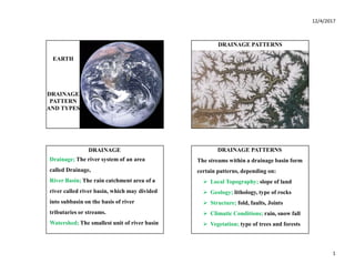
DRAINAGE PATTERNS
DRAINAGE
Drainage; The river system of an area
called Drainage,
River Basin; The rain catchment area of a
river called river basin, which may divided
into subbasin on the basis of river
tributaries or streams.
Watershed; The smallest unit of river basin
DRAINAGE PATTERNS
The streams within a drainage basin form
certain patterns, depending on:
Local Topography; slope of land
Geology; lithology, type of rocks
Structure; fold, faults, Joints
Climatic Conditions; rain, snow fall
Vegetation; type of trees and forests
2. 12/4/2017
2
TYPES OF DRAINAGE PATTERN
Dendritic Drainage Pattern
Trellis Drainage Pattern
Rectangular Drainage Pattern
Radial Drainage Pattern
Parallel Drainage Pattern
DENDRITIC DRAINAGE PATTERN
Dendritic Pattern develops where the
river channel follows the slope of the
terrain.
The stream with it’s tributaries resembles
the branches of a tree.
Forms V-shaped valleys
Rocks are impervious and nonporous
DENDRITIC DRAINAGE PATTERN TRELLIS DRAINAGE PATTERN
A river joined by its tributaries, at
approximately right angles, develop a
Trellis pattern.
Pattern develops where hard and soft
rocks exist parallel to each other.
Trellis drainage is characteristic of folded
mountains.
3. 12/4/2017
3
TRELLIS DRAINAGE PATTERN
RECTANGULAR DRAINAGE PATTERN
Rectangular Drainage Pattern develop
in rocks uniformly resistance to
erosion.
The rocks are strongly jointed,
normally having two set of joints at
right angles
RECTANGULAR DRAINAGE PATTERN
RADIAL DRAINAGE PATTERN
Radial Drainage develops when stream
flow in different directions from a central
peak, volcano, or dome like structure.
Streams radiate outward from a central
high point, the drainage may exhibit a
combination of radial and annular pattern
4. 12/4/2017
4
RADIAL DRAINAGE PATTERN
ANNULAR DRAINAGE PATTERN
Annular Drainage develop by streams
following a roughly circular or concentric
path making a ring like pattern.
Pattern develop in structural domes or
basins where sedimentary rocks of varying
hardness are exposed to the surface.
ANNULAR DRAINAGE PATTERN
PARALLEL DRAINAGE PATTERN
The Parallel Drainage Pattern develops
in an area of steep slopes
Parallel and elongated land forms
outcropping resistant rock bands.
The streams are swift, straight with few
tributaries.
5. 12/4/2017
5
PARALLEL DRAINAGE PATTERN CENTRIPETAL DRAINAGE PATTERN
Also called Inland Drainage Pattern
Its opposite to Radial Pattern
Streams emerge from surrounding upland
areas
These flow down to converge in a central
low land, depression, basin or crater lake
CENTRIPETAL DRAINAGE PATTERN
DRAINAGE PATTERN
Some time a combination of many
Drainage Pattern may be found in a
same River Basin or Drainage System.