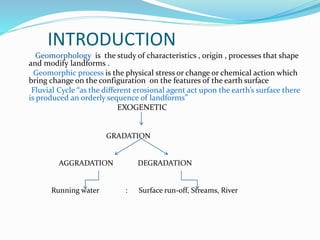
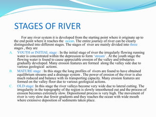
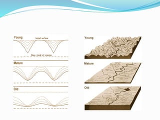
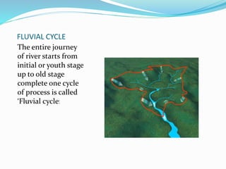
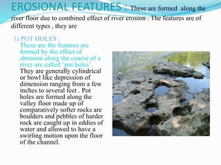
The document discusses the fluvial cycle and geological processes of rivers. It begins by introducing geomorphology and defining the fluvial cycle. It then describes the three stages of river development: youth, mature, and old age. Next, it explains the fluvial cycle and the geological actions of rivers, including erosion, transportation, and deposition. It provides details on various erosion features and processes, methods of transportation, and types of depositional features like deltas and alluvial fans. In concluding, the fluvial cycle represents the complete journey of a river from its initial to old stage through the geological processes of erosion, transportation, and deposition.
Komattite
Named after the Komati River in South Africa.
first described by Morris and Richard (twins) for ultramafic units in the Barberton Greenstone belt of South Africa.
Mostly of komatiite are Archean age
distributed in the Archaean shield areas.
Also a few are Proterozoic and Phanerozoic.
In all ages komatiites are highly magnesium.
Mostly a volcanic rock; occasionally intrusive.
Mafic rocks were identified as extrusive because of their volcanic textures and structures, and they seem to have been accepted as a normal component of Archean volcanic successions, Abitibi in Canada.
The ultramafic rocks were interpreted as intrusive which are founded as sills and dykes, Barberton in South Africa.
Spinifex texture-typical of Komatiites:
Fluvial Morphology handbook for students.
Contents are: definition, scope, importance of Fluvial Morphology, sediment load, channel pattern and process, role sediment to build delta, Reynolds number, Froude Number, channel pattern of Tista and Jamuna River, causes and consequences of flood, benefit of flood, flood and floodplain, hydraulic geometry, water resource management (in Bangladesh), hydrograph, origin and development of river, tributary and distributary and many more.
Rivers are powerful geological agents that shape the Earth's surface through a variety of processes. The geologic action of rivers includes erosion, transportation, and deposition, which collectively contribute to the formation and modification of landscapes. Here's a brief overview of these processes:
Erosion:
Abrasion: The river carries sediments (such as rocks and pebbles) that can wear away the riverbed and banks over time.
Hydraulic action: The force of flowing water can dislodge and transport loose particles, further eroding the riverbed.
Transportation:
Traction: Large particles, like boulders and pebbles, are rolled along the riverbed by the force of the water.
Saltation: Smaller particles are bounced or skipped along the riverbed.
Suspension: Fine particles, like silt and clay, are carried in the flow of the water without directly touching the riverbed.
Solution: Dissolved minerals are carried in the water without being visible, contributing to the river's overall load.
Deposition:
When the velocity of the river decreases, it loses the ability to transport certain sizes of particles. As a result, these particles are deposited along the riverbed or banks.
Larger particles are deposited first, closer to the river source, while smaller particles may be transported farther downstream before deposition.
Meandering and Oxbow Lakes:
Over time, rivers can create meanders or bends in their course. As the outer bank of a meander erodes and the inner bank accumulates sediment, the meander may migrate.
Eventually, a meander may become so pronounced that the river cuts through the neck of the meander, forming an oxbow lake.
Delta Formation:
When a river enters a standing body of water, like an ocean or a lake, the reduced velocity causes sediment deposition. This can lead to the formation of a delta, a fan-shaped landform composed of sediment carried by the river.
Canyon Formation:
In areas with resistant rock layers, rivers can erode deep canyons over time. The Colorado River carving out the Grand Canyon is a notable example.
Valley Formation:
Rivers contribute to the formation of valleys through erosion and transportation of sediment, shaping the landscape over millions of years.
The geologic action of rivers is dynamic and continuously shapes the Earth's surface, playing a crucial role in the ongoing process of landscape evolution
Geological action of river or Fluvial processes
The geological action of river is divided chiefly into three parts as Erosion, Transportation and Deposition.
Erosion: River erosion is mainly due to mechanical breaking down of rock fragment. The chemical action of
rivers is minimal. A wide variety of processes are involved in river erosion as follows;
a. Hydraulic action: It is the process of mechanical loosening or removal of the material by the action of the water
alone. The effectiveness of hydraulic action of a river is depends on gradient, velocity of the stream, width, depth
and shape of the channel and discharge.
b. Abrasion: The process of wearing-away of bed rock surfaces by mechanical processes such as rubbing, cutting,
scratching, grinding and polishing etc. is known as abrasion.
c. Attrition: The process of mechanical wearing and tearing of the transported rock fragments into smaller fragments
due to mutual impact and collision.
d. Cavitation: Highly turbulent rivers in rocky channels erode their beds by hydraulic plucking, in which pieces of
bed rocks are lifted out by strong eddies spiraling up around vertical axes. This sucking out of the rock pieces
produces cavities or depressions within the rock. This type of process is called cavitation.
e. Corrosion: The chemical processes of rock erosion by river water are known as corrosion or solution.
Important erosional features:
a. Potholes: These are cylindrical or bowl-like depressions in the rocky beds of streams, which are excavated in the
floors of the streams by extensive, localized abrasion. These are commonly found in softer bedrocks.
b. Water fall: These are defined as magnificent jumps made by stream or river water at certain specific parts of their
course where there is a sudden and considerable drop in the gradient of the channel.
c. River valleys: The river channel carved out by the flow of running water is commonly known as a river valley.
d. Gorges or canyons: During the river erosion, down cutting of its cannel gives rise to a deep narrow valley with
vertical or steep walls. Such a valley is termed as a gorge or canyons.
e. Escarpments: These are erosional land forms produces by rivers in regions composed of alternating beds of hard
and soft rocks. During river erosion soft rocks erode much faster than hard rocks, leaving behind steep slopes on
one side and a gentle slope on the other. The steep slope side is known as the escarpment.
Hog’s back: This is a sharp ridge like structure with high angle sides on two sides formed by harder rocks in an
inclined series of beds.
Mesa and butte: In regions of horizontal strata in which isolated portions of land is capped by a hard, erosion-
resistant bed, the erosional landforms produced will have an isolated flat-topped land area with seep sides,
commonly known as mesa. Isolated masses without flat tops are called buttes.
Transportation: A river is a most powerful agent of transportation. All the material being transported by a
River is a most Important agent in geological field and most important roll of the physical, Chemical and biological erosion. It is common factors of river.
Francesca Gottschalk - How can education support child empowerment.pptxEduSkills OECD
Francesca Gottschalk from the OECD’s Centre for Educational Research and Innovation presents at the Ask an Expert Webinar: How can education support child empowerment?
Operation “Blue Star” is the only event in the history of Independent India where the state went into war with its own people. Even after about 40 years it is not clear if it was culmination of states anger over people of the region, a political game of power or start of dictatorial chapter in the democratic setup.
The people of Punjab felt alienated from main stream due to denial of their just demands during a long democratic struggle since independence. As it happen all over the word, it led to militant struggle with great loss of lives of military, police and civilian personnel. Killing of Indira Gandhi and massacre of innocent Sikhs in Delhi and other India cities was also associated with this movement.
Instructions for Submissions thorugh G- Classroom.pptxJheel Barad
This presentation provides a briefing on how to upload submissions and documents in Google Classroom. It was prepared as part of an orientation for new Sainik School in-service teacher trainees. As a training officer, my goal is to ensure that you are comfortable and proficient with this essential tool for managing assignments and fostering student engagement.
Introduction to AI for Nonprofits with Tapp NetworkTechSoup
Dive into the world of AI! Experts Jon Hill and Tareq Monaur will guide you through AI's role in enhancing nonprofit websites and basic marketing strategies, making it easy to understand and apply.
Embracing GenAI - A Strategic ImperativePeter Windle
Artificial Intelligence (AI) technologies such as Generative AI, Image Generators and Large Language Models have had a dramatic impact on teaching, learning and assessment over the past 18 months. The most immediate threat AI posed was to Academic Integrity with Higher Education Institutes (HEIs) focusing their efforts on combating the use of GenAI in assessment. Guidelines were developed for staff and students, policies put in place too. Innovative educators have forged paths in the use of Generative AI for teaching, learning and assessments leading to pockets of transformation springing up across HEIs, often with little or no top-down guidance, support or direction.
This Gasta posits a strategic approach to integrating AI into HEIs to prepare staff, students and the curriculum for an evolving world and workplace. We will highlight the advantages of working with these technologies beyond the realm of teaching, learning and assessment by considering prompt engineering skills, industry impact, curriculum changes, and the need for staff upskilling. In contrast, not engaging strategically with Generative AI poses risks, including falling behind peers, missed opportunities and failing to ensure our graduates remain employable. The rapid evolution of AI technologies necessitates a proactive and strategic approach if we are to remain relevant.
Macroeconomics- Movie Location
This will be used as part of your Personal Professional Portfolio once graded.
Objective:
Prepare a presentation or a paper using research, basic comparative analysis, data organization and application of economic information. You will make an informed assessment of an economic climate outside of the United States to accomplish an entertainment industry objective.
Acetabularia Information For Class 9 .docxvaibhavrinwa19
Acetabularia acetabulum is a single-celled green alga that in its vegetative state is morphologically differentiated into a basal rhizoid and an axially elongated stalk, which bears whorls of branching hairs. The single diploid nucleus resides in the rhizoid.
3. INTRODUCTION
Geomorphology is the study of characteristics , origin , processes that shape
and modify landforms .
Geomorphic process is the physical stress or change or chemical action which
bring change on the configuration on the features of the earth surface
Fluvial Cycle “as the different erosional agent act upon the earth’s surface there
is produced an orderly sequence of landforms”
EXOGENETIC
GRADATION
AGGRADATION DEGRADATION
Running water : Surface run-off, Streams, River
4. STAGES OF RIVER
For any river system it is developed from the starting point where it originate up to
the end point where it reaches the ocean. The entire journey of river can be clearly
distinguished into different stages. The stages of river are mainly divided into three
stages , they are
A. YOUTH or INITIAL stage : In the initial stage of river the irregularly flowing running
water is concentrated within the depression to form ‘stream’ . At the youth stage the
flowing water is found to cause appreciable erosion of the valley and tributaries
gradually developed. Many erosion features are formed along the valley side due to
various geological actions.
B. MATURE stage : In this stage the long profiles of rivers are found to have obtained
equilibrium streams and a drainage system . The power of erosion of the river is also
much reduced and balance with its transporting capacity. Many erosion features are
formed on the valley floor due to various geological actions.
C. OLD stage: In this stage the river valleys become very wide due to lateral cutting. The
irregularity in the topography of the region is slowly smoothened out and the process of
erosion becomes extremely slow. Depositional process is very high. The movement of
river is very slow due fewer gradients and they reaches the ocean with wide mouth
where extensive deposition of sediments taken place.
5.
6. FLUVIAL CYCLE
The entire journey
of river starts from
initial or youth stage
up to old stage
complete one cycle
of process is called
‘Fluvial cycle’.
7. GEOLOGICAL ACTION OF RIVER
The water flows in a river along its seaward course
erode the land over which it flows brings about its
mechanical breakdown of rocks ,chemical decomposition
of rocks, denudation of the country rock , transport the
rock debris which are formed during process of weathering
and finally deposit the transported material under
favorable conditions . So the geological action of river
includes various processes , they are
1.River erosion
2.River transportation
3.River deposition
8. RIVER EROSION
The river erosion brought large scale changes on the surface of the earth .
These changes are made by different distinct erosion processes , they are
A. Hydraulic action : It is a process of mechanical breaking down of rock
masses mainly due to continuous impact of water moving with great velocity
along the channel is called ‘hydraulic action’ . This process also leads to the
domination of erosion process along the upper part of the river where
gradient of the surface generally is very high . The wear and tear of the rocks
due to continuous impact of running water produce large debris is dropped
through discharge.
The deflation action of wind and hydraulic action of river are similar and more
powerful processes in which kinetic energy are associated . The product of
hydraulic action by river are of variable in size from large boulders to fine silt
and clay and these are transported along with the flow until they drop down
and settle under suitable condition.
B. Cavitation : It is a distinct and rare type of hydraulic action performed by
running water. It is particularly observed where river water suddenly acquires
exceptionally high velocity such as at the location of a waterfall .
9. C. Abrasion : The process of mechanical breaking down of the
bed rocks due to the impact of fragments which is carried by
water during their flow on the floor of the river valley . This
process is called ‘abrasion’. It is just similar process of wind
abrasion . The effect of abrasion of river along the course in the
development of ‘pot holes’ formed upon the valley floor.
D. Attrition : It is the process of mechanical breaking down of the
transported rock fragments due to impact among themselves
has been described as ‘attrition’ . The mechanical collision
among fragments naturally causes further wear and tear of
themselves in addition to caused by abrasion . The rolling
boulders , pebbles and small fragments travelled in suspension
collide with one another during their transportation.
10. E. Corrosion : The slow but steady ‘chemical (especially
solvent ) action of the stream water on the rocks is expressed by
the term corrosion.
The extent of corrosion depends much on the
composition of rocks and also on the composition of flowing
water. Thus , all rocks are not equally susceptible to corrosive
action of stream water. Limestone , gypsum and rock salt
bodies are soluble in water to varying degrees. The stream may
hardly corrode sandstone , quartzite , granites and gneisses.
11. EROSIONAL FEATURES : These are formed along the
river floor due to combined effect of river erosion . The features are of
different types , they are
1) POT HOLES :
These are the features are
formed by the effect of
abrasion along the course of a
river are called ‘pot holes’.
They are generally cylindrical
or bowl like depression of
dimension ranging from a few
inches to several feet . Pot
holes are formed along the
valley floor made up of
comparatively softer rocks are
boulders and pebbles of harder
rock are caught up in eddies of
water and allowed to have a
swirling motion upon the floor
of the channel.
12. 2) V-SHAPED VALLEYS :
Valleys are defined as a low
land or depression
surrounded by inclined hill
slopes and mountain. The
origin deepening lengthening
and widening of river valleys
developed due to deferential
erosion processes . The V-
shaped of the river valley
developed in the initial stages
of river . The transverse
profile of the river valley is
look like ‘V’ shape.
13. 3) WATER FALLS :
These are defined as
magnificent jumps made by stream
or river water at certain specific
parts of there is a sudden and
considerable drop in the gradient
of the channel . In a water fall the
streams from a considerable height
. Successive falls of smaller
heights are sometimes referred as
‘rapids’ and ‘cascades’. Gently
upstream sloping strata of
alternate hard and soft characters
are favorable for the formation of
waterfalls , rapids and cascades.
Ex: JOG FALLS in Gerusoppe found
in Sharavathi river.
14. 4) MEANDERS :
Rivers are flowing usually in a
curved manner along during its
course . This curving nature more
or less Zigzag paths and the
curvatures along the course are
known as ‘Meanders’. These are
developed mostly in the middle
and lower reaches of major
streams where lateral erosion and
deposition along opposite banks
due to different geological
processes . Meanders are present
initially during any river course
since the running water has the
tendency to follow the direction of
maximum slope of the topography.
15. 5) OX-bow lake :
Due to the excavation of pre-
existing of meanders along the
outer curve by the erosion
resulting river takes up in the
plains round-about course and
during floods the running water
may cut straight through a
meander and follow a shorter
course abandoning its previous
round about track. Such
abandoned meanders containing
some confined water, give rise to
‘horse- shoe’ or ‘ox-bow’ lakes.
16. RIVER TRANSPORTAION
A) SUSPENSION :
In the processes of transportation its velocity
depends upon the gradient of the valley floor , shape
and size of the channel and discharge of the river.
Abrasion and attrition always work together and
produce fine river particles like fine sand, silt and
clay are transported to a greater distance in
suspension. Suspension is one of the processes of
transportation of fine rock particles for a longer
distance and suspended particles are settled when
the velocity checked.
17. B) SALTATION:
In the process of saltation the particles are transported
by means of series of jumps resulting in the development
of smooth surface and also particles get sorted.
C) SOLUTION:
Solution is one of the process in which readily soluble
substances are dissolved in water and removed in solution
and some soluble constituents are soluble in solution.
Ex ; Carbonate rocks are easily dissolved and removed in
solution during their course of journey in different terrain.
18. RIVER DEPOSITION
As soon as the velocity of running water
decreases, its transporting capacity decreases . As a
result of its load is dropped down . The larger particles
are deposited its enroot and the lighter and smaller
particles are transported in suspension and saltation to
a very great distance, in keeping with the gradual fall
of the power of transportation of the river along its
seaward course. The deposition along the course of a
river known as ‘fluvial deposits’. There are different
types of fluvial deposits in which alluvial fans and
delta deposits are important.
19. ALLUVIAL FANS :
The rock fragments of the size
of boulders and pebbles
transported due to velocity of
the river is considerable. Such
accumulation of boulders and
pebbles at the point where
running water enters into the
plains is known as ‘alluvial fans’.
The name alluvial fans are so
because the rock fragments are
arranged in a ‘radiating fan like
pattern’. The term ‘alluvial fan’ is
used when the slope of the
deposit is below 10° and ‘alluvial
cone’ when the slope is in the
range of 10°-50°.
21. Definition of Delta:
Deltas are defined as alluvial deposits of roughly
triangular shape that are deposited by major rivers at their
mouths i.e. where they enter sea . The term Delta was first
used by Herodotous , some 2500 years ago , for the delta
(△) shaped deposit of the river Nile (in Egypt) at its entry into
the Mediterranean Sea.
Structres : Deltas are quite complex in their structures because
of their formation , evolution and modification with passage of
time. A typical simple delta is commonly made of three layers
of which only the top layer may be sub aerial i. e. exposed on
the surface.
22. 1.The bottom-set beds which form the base of the delta
and are characterized by a gentle seaward inclination.
These are generally made up of fine-sized particles.
2.The fore-set beds intermediate layers and often show
very steep inclination. The fore set are made up of
thick layers of sand and clay.
3.The top-set beds are relatively thin layers also showing
gentle slopes over the fore set beds. These are laid
down on the fore set beds again and again during
subsequent flooding.