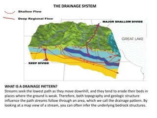
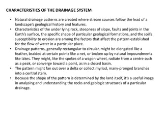
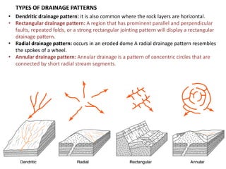
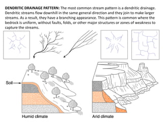
Streams flow downhill through the lowest areas of the landscape, eroding paths known as drainage patterns. A stream's drainage pattern is influenced by the underlying topography and geology. There are several common drainage patterns, including dendritic patterns where many small streams join into larger rivers, rectangular patterns in areas with parallel faults, and radial patterns resembling spokes on a wheel around mountain domes. The most frequent pattern is dendritic, occurring where the bedrock is uniform. Drainage patterns provide insight into the geological structures of the landscape.
2. WHAT IS A DRAINAGE PATTERN?
Streams seek the lowest path as they move downhill, and they tend to erode their beds in
places where the ground is weak. Therefore, both topography and geologic structure
influence the path streams follow through an area, which we call the drainage pattern. By
looking at a map view of a stream, you can often infer the underlying bedrock structures.
THE DRAINAGE SYSTEM
3. • Natural drainage patterns are created where stream courses follow the lead of a
landscape’s geological history and features.
• Characteristics of the under lying rock, steepness of slope, faults and joints in the
Earth’s surface, the specific shape of particular geological formations, and the soil’s
susceptibility to erosion are among the factors that affect the pattern established
for the flow of water in a particular place.
• Drainage patterns, generally rectangular to circular, might be elongated like a
feather, braided at certain points like a net, or broken up by natural impoundments
like lakes. They might, like the spokes of a wagon wheel, radiate from a centre such
as a peak, or converge toward a point, as in a closed basin.
• The pattern might fan out over a delta or collect myriad, many-pronged branches
into a central stem.
• Because the shape of the pattern is determined by the land itself, it’s a useful image
in analysing and understanding the rocks and geologic structures of a particular
drainage.
CHARACTERISTICS OF THE DRAINAGE SYSTEM
4. • Dendritic drainage pattern: it is also common where the rock layers are horizontal.
• Rectangular drainage pattern: A region that has prominent parallel and perpendicular
faults, repeated folds, or a strong rectangular jointing pattern will display a rectangular
drainage pattern.
• Radial drainage pattern: occurs in an eroded dome A radial drainage pattern resembles
the spokes of a wheel.
• Annular drainage pattern: Annular drainage is a pattern of concentric circles that are
connected by short radial stream segments.
TYPES OF DRAINAGE PATTERNS
5. DENDRITIC DRAINAGE PATTERN: The most common stream pattern is a dendritic drainage.
Dendritic streams flow downhill in the same general direction and they join to make larger
streams. As a result, they have a branching appearance. This pattern is common where the
bedrock is uniform, without faults, folds, or other major structures or zones of weakness to
capture the streams.
6. Rippling along rough surfaces and the beautiful meadows, the numerous rivers that dot
Indian mainland are central to our history as well as to Indian mythology. The main rivers
of the Himalayas group are the Indus, the Ganga and the Brahmaputra. These rivers are
both snow-fed and rain-fed and therefore they are flow through so many year.
Himalayan rivers discharge about 70% of their inflow into the sea. This includes about
5% from central Indian rivers. They join the Ganga and drain into the Bay of Bengal.
HIMALAYAN RIVERS
INDUS RIVERS
It has believed by the early
Tibetans that this forceful and
full river that guarded the
frontiers of united India rises
from the lake Mansarovar in
Tibet. A few expeditions later, it
was discovered that the Indus
actually originates a few
kilometres north of lake
Mansarovar and together with it
arise the Brahmaputra and the
river Sutlej, through Mansarovar.
7. GANGA RIVERS
Northern Uttaranchal is the source of Bhagirathi, which joins with Alaknanda to form
Ganga at the craggy canyon-carved town of Devprayag. Interestingly, the sources of
Indus and the Brahmaputra are also geographically fairly close then takes a sharp turn
near the north-eastern tip of India, gathers momentum through Assam before joining
the major stream of the Ganga near Dacca in Bangladesh to become the mighty
Padma, river of joy and sorrow for much of Bangladesh.
8.
9. BIBLIOGRAPHY
new york natural wonders .
INDIAN drainage systems
Wikipedia, the free encyclopedia
topographic map,
drainage basin