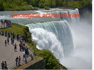
Geological action of river and wind.ppt

Geological action of river or Fluvial processes The geological action of river is divided chiefly into three parts as Erosion, Transportation and Deposition. Erosion: River erosion is mainly due to mechanical breaking down of rock fragment. The chemical action of rivers is minimal. A wide variety of processes are involved in river erosion as follows; a. Hydraulic action: It is the process of mechanical loosening or removal of the material by the action of the water alone. The effectiveness of hydraulic action of a river is depends on gradient, velocity of the stream, width, depth and shape of the channel and discharge. b. Abrasion: The process of wearing-away of bed rock surfaces by mechanical processes such as rubbing, cutting, scratching, grinding and polishing etc. is known as abrasion. c. Attrition: The process of mechanical wearing and tearing of the transported rock fragments into smaller fragments due to mutual impact and collision. d. Cavitation: Highly turbulent rivers in rocky channels erode their beds by hydraulic plucking, in which pieces of bed rocks are lifted out by strong eddies spiraling up around vertical axes. This sucking out of the rock pieces produces cavities or depressions within the rock. This type of process is called cavitation. e. Corrosion: The chemical processes of rock erosion by river water are known as corrosion or solution. Important erosional features: a. Potholes: These are cylindrical or bowl-like depressions in the rocky beds of streams, which are excavated in the floors of the streams by extensive, localized abrasion. These are commonly found in softer bedrocks. b. Water fall: These are defined as magnificent jumps made by stream or river water at certain specific parts of their course where there is a sudden and considerable drop in the gradient of the channel. c. River valleys: The river channel carved out by the flow of running water is commonly known as a river valley. d. Gorges or canyons: During the river erosion, down cutting of its cannel gives rise to a deep narrow valley with vertical or steep walls. Such a valley is termed as a gorge or canyons. e. Escarpments: These are erosional land forms produces by rivers in regions composed of alternating beds of hard and soft rocks. During river erosion soft rocks erode much faster than hard rocks, leaving behind steep slopes on one side and a gentle slope on the other. The steep slope side is known as the escarpment. Hog’s back: This is a sharp ridge like structure with high angle sides on two sides formed by harder rocks in an inclined series of beds. Mesa and butte: In regions of horizontal strata in which isolated portions of land is capped by a hard, erosion- resistant bed, the erosional landforms produced will have an isolated flat-topped land area with seep sides, commonly known as mesa. Isolated masses without flat tops are called buttes. Transportation: A river is a most powerful agent of transportation. All the material being transported by a

Recommended
More Related Content
What's hot
What's hot (20)
Similar to Geological action of river and wind.ppt
Similar to Geological action of river and wind.ppt (20)
Recently uploaded
Recently uploaded (20)
Geological action of river and wind.ppt
- 1. Geological action of river
- 2. ABOUT STREAM Streams alter the Earth's landscape through the movement of water and sediment . Streams are powerful erosive agents moving material from their bed and banks. In mountainous regions, stream erosion often produces deep channels and canyons. Streams also deposit vast amounts of sediment on the terrestrial landscape and within lakes and ocean basins.
- 3. TYPES OF STREAMS CONSEQUENT STREAM:- In any area these are the first stream to have developed in accordance with the topography of the area. SUBSEQUENT STREAM:-These are the generally tributaries to the consequent streams. The characters of the rocks over which they flow controls their direction of flow OBSEQUENT STREAM:-These are tributaries to the subsequent streams. In most cases their direction of flow may be opposite to the main or consequent stream. INSEQUENT STREAM:-They may also be called irregular stream. These are found to flow in canals that show no well defined relationship with either the slope of the area or the character of the rocks.
- 5. DRAINAGE SYSTEM A drainage system is the pattern formed by the streams, rivers, and lakes in a particular drainage basin. They are governed by the topography of the land whether a particular region is dominated by hard or soft rocks, and the gradient of the land. Geomorphologists and hydrologists often view streams as being part of drainage basins. A drainage basin is the topographic region from which a stream receives runoff, through flow, and groundwater flow. Drainage basins are divided from each other by topographic barriers called a watershed.
- 6. Types of drainage system DENDRETIC: PINNATE: TRLLIS RECTANGULAR PARALLEL: CENTRIPETAL: CENTRIFUGAL RADIAL:
- 11. The Work of Rivers The erosional work of streams/rivers carves and shapes the landscape through which they flow. Three functions of rivers a. Erosion b. Transportation c. Deposition
- 12. How rivers erode HYDRAULIC ACTION The force of the water weakens and breaks up the rocks ABRASION The material carried in the river wears away the river bed ATTRITION As the pebbles carried by the river crash into each other,they become smaller and rounder SOLUTION The water in the river dissolves the minerals in the rocks
- 13. How rivers transport Rolling stones along the river bed.( needs lots of energy) Traction Suspension Clay sized particles are carried along by the river flow Saltation Sand sized particles bounce along the riverbed Solution Some minerals are dissolved by the riverwater river flow
- 18. FEATURES OF THE UPPER COURSE EROSIONAL FEATURES: V-SHAPED VALLEYS WITH INTERLOCKING SPURS POT HOLES ON RIVER BED WATERFALLS AND RAPIDS
- 19. The River Avon has smoothed off parts of this hard igneous rock. . .
- 20. Formation of a waterfall Soft rock Hard rock Steep sides ( gorge ) Vertical erosion Forms plunge pool Undercutting erodes the softer rock forming an overhang The overhang Eventually collapses The process starts again Eroded rock Waterfall Retreats upstream
- 21. PLUNGE POOL UNDERCUTTING OF SOFT ROCK OVERHANG WATERFALL RETREATS . . UPSTREAM . .
- 23. MEANDERS Flood plain Meanders © Used with the permission of the Geological Survey of Canada, Natural Resources Canada Available at http://sts.gsc.nrcan.gc.ca – Terrain Science Division Most erosion on the outside of the bend .. Fastest flow Possible break through point Possible ox-bow lake
- 24. Fastest current slowest current Outer bank Is undercut Slip off slope ( river beach ) Deposition of Sand and shingle Deepest part of the river Bank will collapse Small river cliff River bend
- 25. Formation of an ox-bow lake The meanders change shape through time At the bends the river flows faster at the outside The bends migrate Sideways leaving deposits on the inside Of the bend The erosion makes the Meanders more pronounced Small river cliff is formed Most erosion Most deposition (Slip off slope) Some bends get closer and closer The neck gets narrower and narrower Eventually during a period of heavy river flow it cuts through The river now follows the new route The old meander Is left as a small lake (OX - BOW lake) © Used with the permission of the Geological Survey of Canada, Natural Resources Canada Available at http://sts.gsc.nrcan.gc.ca – Terrain Science Division
- 26. Want to see that again ?
- 27. NARROW MEANDER NECK FUTURE OX-BOW LAKE
- 28. Gentle valley sides Flat floodplain Layers of silt Deposited during floods Coarse material Forms natural levees River is actually flowing above The floodplain !! Levees is often artificially strengthened
- 29. Characteristics Upper Course Middle Course Lower Course Slope Width Depth Straightness Load Main work Valley width Type of load usually steep narrow shallow winding little large/small angular erosion transportation quite steep quite wide quite deep meandering some medium/small rounded Transportation narrow gentle quite wide wide deep big meanders lots small+ rounded transportation deposition wide
- 32. Alluvial cone
- 33. Canyon A long ,deep,narrow,very Steep-sided valley cut Primarily in bed rock in an High local relief (mountain Or high plateau terrain)
- 34. Delta: landform where the mouth of river flows into an ocean, sea, lake , estuary or another river
- 35. Estuary:
- 36. Reproduced with kind permission of Ordnance Survey © Crown Copyright NC/03/18990 tributaries ox-bow lake meander V shaped valley Steep Valley sides Flood plain
- 37. Geological action of wind
- 38. Introduction: The air currents in motion is called wind . The wind is an important agent of erosion, transportation, deposition. Its work particularly seen in arid regions. Erosion: wind does erosion in three ways. • Deflation: The process of removal of particles of dust and sand by strong winds is called deflation. This process operates well in dry regions with little or no rainfall i.e. desert area. (Lifting and removal of loose material.) • Abrasion: The process of wearing and tearing of country rock surfaces by wind borne particles is called wind abrasion. Sand grains are used as tools for eroding rocks. • Attrition: The wear and tearing suffered by load material due to their mutual impacts during transportation process by wind is called attrition.Collide against one another.
- 44. Deflation sometimes leads to the formation of depressions or hollows on the land surface. At few places the depressions with its base touching the water table at quite a depth are called as blowouts.
- 45. Ventifacts: These are polished and faceted rock fragments produced by the abrasive action of windblown sand.
- 46. Saltation: Type of transportation which is carried out through a series of bounces is called saltation. Suspension: The finest materials derived from clay and slit move with the wind quickly and remain in suspension in the air for quite some time and settle very slowly. Surface creep: Type of transportation method carried out through rolling and creeping is called surface creep. It is also known as traction.
- 47. Deposition • When, the velocity of the wind is checked due to some obstacles, a part or whole of the drifting material carried by the wind will start getting deposited and this type of deposits are called aeolian deposits. • Loess: It is a deposit of windblown silt and clay particles. • Dunes (Sand dunes): These are variously shaped deposits of sand grade particles.
- 48. Barchans: These are asymmetrical, crescent shaped (typically half moon shape) dunes in which the points of the crescent are directed down wind side.
- 49. Longitudinal dunes: These are large symmetrical ridges of sand parallel to the wind direction. Transverse dunes: These are elongated dunes form at right angles to the prevailing wind. Parabolic dunes: These dunes are parabolic in shape and their horns pointing towards the direction opposite to that of the blowing wind.
- 51. THANK U