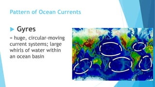
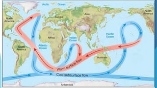
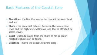
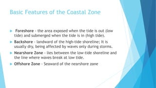
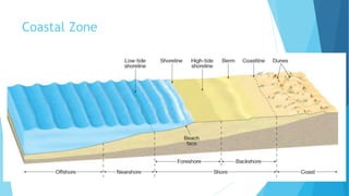
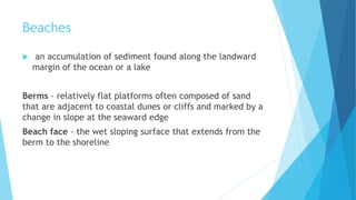
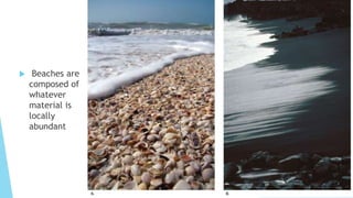
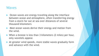
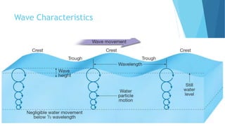
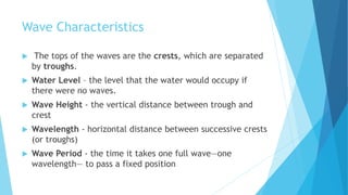
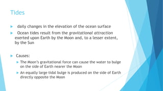
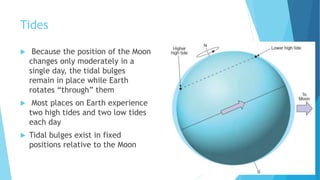
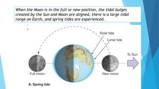
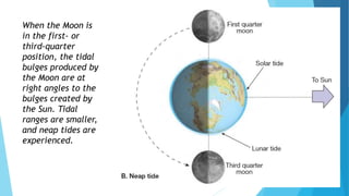
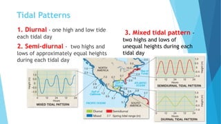
Dynamic Ocean
Oceanography Part 3
Ocean Currents
Ocean Currents
 masses of ocean water that flow from
one place to another
 develop from friction between the
ocean and the wind that blows across
its surface

 Factors affecting surface current patterns:
pattern of global winds
distribution of major landmasses
Gravity
Friction
Coriolis effect
Pattern of Ocean Currents
 Gyres
= huge, circular-moving
current systems; large
whirls of water within
an ocean basin
North Pacific Gyre
South Pacific Gyre
North Atlantic
Gyre
South
Atlantic
GyreIndian Ocean
Gyre
5 Main Gyres
1. North Pacific Gyre – clockwise
2. South Pacific Gyre - counterclockwise
3. North Atlantic Gyre - clockwise
4. South Atlantic Gyre - counterclockwise
5. Indian Ocean Gyre - counterclockwise
Average Surface Ocean Currents
in February–March
When the winds change direction,
the surface currents also reverse
direction.
North Pacific Gyre
 4 Major Currents
1. North Equatorial Current
2. Kuroshio Current
3. North Pacific Current
4. California Current
South Pacific Gyre
 4 Main Currents
1. South Equatorial Current
2. East Australian Current
3. West Wind Drift
4. Peru Current
North Atlantic Gyre
 4 Major Currents
1. North Equatorial Current
2. Gulf Stream Current
3. North Atlantic Current
4. Canary Current
South Atlantic Gyre
 4 Main Currents
1. South Equatorial Current
2. Brazil Current
3. West Wind Drift
4. Benguela Current
Indian Ocean Gyre
 4 Main Currents
1. South Equatorial Current
2. Agulhas Current
3. West Wind Drift
4. West Australian Current
 Anyone who navigates the oceans
need to be aware of the currents.
 Voyage time can be reduced by
traveling with the current
Ocean Currents Influence Climate
 When currents from low-latitude regions move
to higher latitudes, they transfer heat from
warmer to cooler areas on Earth.
 Ex: the North Atlantic Current—an extension of the warm Gulf
Stream—keeps Great Britain and much of northwestern Europe
warmer during the winter than one would expect for their
latitudes, which are similar to the latitudes of Alaska and
Labrador
Ocean Currents Influence Climate
 The prevailing westerly winds carry the
moderating effects far inland.
 Ex: Berlin, Germany (52 degrees north latitude),
has an average January temperature similar to that
experienced at New York City, which lies 12 degrees
latitude farther south
Ocean Currents
Influence Climate
 Cold currents originating
in cold high-latitude
regions tend to moderate
the warm temperatures of
adjacent land areas.
 Ex: the cool Benguela Current off the
western coast of southern Africa
moderates the tropical heat along this
coast. Walvis Bay (23° south latitude),
a town adjacent to the Benguela
Current, is 5° C (9° F) cooler in
summer than Durban, which is 6°
latitude farther poleward but on the
eastern side of South Africa, away
from the influence of the current
Ocean Currents Influence Climate
Ocean currents play a major role
in maintaining Earth’s heat
balance
Deep Ocean Circulation
 This component of ocean circulation is a response to
density differences among water masses that cause
denser water to sink and slowly spread out beneath the
surface
 also referred to as thermohaline circulation
 Recall: An increase in seawater density can be caused
by a decrease in temperature or an increase in
salinity.
The Shoreline
Basic Features of the Coastal Zone
 Shoreline - the line that marks the contact between land
and sea
 Shore - the area that extends between the lowest tide
level and the highest elevation on land that is affected by
storm waves.
 Coast - extends inland from the shore as far as ocean-
related features can be found.
 Coastline - marks the coast’s seaward edge
Coastal Zone
Basic Features of the Coastal Zone
 Foreshore - the area exposed when the tide is out (low
tide) and submerged when the tide is in (high tide).
 Backshore - landward of the high-tide shoreline; It is
usually dry, being affected by waves only during storms.
 Nearshore Zone - lies between the low-tide shoreline and
the line where waves break at low tide.
 Offshore Zone - Seaward of the nearshore zone
Coastal Zone
Beaches
 an accumulation of sediment found along the landward
margin of the ocean or a lake
Berms - relatively flat platforms often composed of sand
that are adjacent to coastal dunes or cliffs and marked by a
change in slope at the seaward edge
Beach face - the wet sloping surface that extends from the
berm to the shoreline
 Beaches are
composed of
whatever
material is
locally
abundant
Waves
 Ocean waves are energy traveling along the interface
between ocean and atmosphere, often transferring energy
from a storm far out at sea over distances of several
thousand kilometers
 Most ocean waves derive their energy and motion from
the wind.
 When a breeze is less than 3 kilometers (2 miles) per hour,
only wavelets appear.
 At greater wind speeds, more stable waves gradually form
and advance with the wind.
Wave Characteristics
 The tops of the waves are the crests, which are separated
by troughs.
 Water Level – the level that the water would occupy if
there were no waves.
 Wave Height - the vertical distance between trough and
crest
 Wavelength - horizontal distance between successive crests
(or troughs)
 Wave Period - the time it takes one full wave—one
wavelength— to pass a fixed position
Tides
 daily changes in the elevation of the ocean surface
 Ocean tides result from the gravitational attraction
exerted upon Earth by the Moon and, to a lesser extent,
by the Sun
 Causes:
 The Moon’s gravitational force can cause the water to bulge
on the side of Earth nearer the Moon
 An equally large tidal bulge is produced on the side of Earth
directly opposite the Moon
Tides
 Because the position of the Moon
changes only moderately in a
single day, the tidal bulges
remain in place while Earth
rotates “through” them
 Most places on Earth experience
two high tides and two low tides
each day
 Tidal bulges exist in fixed
positions relative to the Moon
When the Moon is in the full or new position, the tidal bulges
created by the Sun and Moon are aligned, there is a large tidal
range on Earth, and spring tides are experienced.
When the Moon is
in the first- or
third-quarter
position, the tidal
bulges produced by
the Moon are at
right angles to the
bulges created by
the Sun. Tidal
ranges are smaller,
and neap tides are
experienced.
Tidal Patterns
3. Mixed tidal pattern -
two highs and lows of
unequal heights during each
tidal day
1. Diurnal - one high and low tide
each tidal day
2. Semi-diurnal - two highs and
lows of approximately equal heights
during each tidal day

Dynamic ocean-1

  • 1.
  • 2.
  • 3.
    Ocean Currents  massesof ocean water that flow from one place to another  develop from friction between the ocean and the wind that blows across its surface 
  • 4.
     Factors affectingsurface current patterns: pattern of global winds distribution of major landmasses Gravity Friction Coriolis effect
  • 5.
    Pattern of OceanCurrents  Gyres = huge, circular-moving current systems; large whirls of water within an ocean basin
  • 6.
    North Pacific Gyre SouthPacific Gyre North Atlantic Gyre South Atlantic GyreIndian Ocean Gyre
  • 7.
    5 Main Gyres 1.North Pacific Gyre – clockwise 2. South Pacific Gyre - counterclockwise 3. North Atlantic Gyre - clockwise 4. South Atlantic Gyre - counterclockwise 5. Indian Ocean Gyre - counterclockwise
  • 8.
    Average Surface OceanCurrents in February–March
  • 9.
    When the windschange direction, the surface currents also reverse direction.
  • 10.
    North Pacific Gyre 4 Major Currents 1. North Equatorial Current 2. Kuroshio Current 3. North Pacific Current 4. California Current
  • 11.
    South Pacific Gyre 4 Main Currents 1. South Equatorial Current 2. East Australian Current 3. West Wind Drift 4. Peru Current
  • 12.
    North Atlantic Gyre 4 Major Currents 1. North Equatorial Current 2. Gulf Stream Current 3. North Atlantic Current 4. Canary Current
  • 13.
    South Atlantic Gyre 4 Main Currents 1. South Equatorial Current 2. Brazil Current 3. West Wind Drift 4. Benguela Current
  • 14.
    Indian Ocean Gyre 4 Main Currents 1. South Equatorial Current 2. Agulhas Current 3. West Wind Drift 4. West Australian Current
  • 15.
     Anyone whonavigates the oceans need to be aware of the currents.
  • 16.
     Voyage timecan be reduced by traveling with the current
  • 17.
    Ocean Currents InfluenceClimate  When currents from low-latitude regions move to higher latitudes, they transfer heat from warmer to cooler areas on Earth.  Ex: the North Atlantic Current—an extension of the warm Gulf Stream—keeps Great Britain and much of northwestern Europe warmer during the winter than one would expect for their latitudes, which are similar to the latitudes of Alaska and Labrador
  • 18.
    Ocean Currents InfluenceClimate  The prevailing westerly winds carry the moderating effects far inland.  Ex: Berlin, Germany (52 degrees north latitude), has an average January temperature similar to that experienced at New York City, which lies 12 degrees latitude farther south
  • 19.
    Ocean Currents Influence Climate Cold currents originating in cold high-latitude regions tend to moderate the warm temperatures of adjacent land areas.  Ex: the cool Benguela Current off the western coast of southern Africa moderates the tropical heat along this coast. Walvis Bay (23° south latitude), a town adjacent to the Benguela Current, is 5° C (9° F) cooler in summer than Durban, which is 6° latitude farther poleward but on the eastern side of South Africa, away from the influence of the current
  • 20.
    Ocean Currents InfluenceClimate Ocean currents play a major role in maintaining Earth’s heat balance
  • 21.
    Deep Ocean Circulation This component of ocean circulation is a response to density differences among water masses that cause denser water to sink and slowly spread out beneath the surface  also referred to as thermohaline circulation  Recall: An increase in seawater density can be caused by a decrease in temperature or an increase in salinity.
  • 23.
  • 24.
    Basic Features ofthe Coastal Zone  Shoreline - the line that marks the contact between land and sea  Shore - the area that extends between the lowest tide level and the highest elevation on land that is affected by storm waves.  Coast - extends inland from the shore as far as ocean- related features can be found.  Coastline - marks the coast’s seaward edge
  • 25.
  • 26.
    Basic Features ofthe Coastal Zone  Foreshore - the area exposed when the tide is out (low tide) and submerged when the tide is in (high tide).  Backshore - landward of the high-tide shoreline; It is usually dry, being affected by waves only during storms.  Nearshore Zone - lies between the low-tide shoreline and the line where waves break at low tide.  Offshore Zone - Seaward of the nearshore zone
  • 27.
  • 28.
    Beaches  an accumulationof sediment found along the landward margin of the ocean or a lake Berms - relatively flat platforms often composed of sand that are adjacent to coastal dunes or cliffs and marked by a change in slope at the seaward edge Beach face - the wet sloping surface that extends from the berm to the shoreline
  • 29.
     Beaches are composedof whatever material is locally abundant
  • 30.
    Waves  Ocean wavesare energy traveling along the interface between ocean and atmosphere, often transferring energy from a storm far out at sea over distances of several thousand kilometers  Most ocean waves derive their energy and motion from the wind.  When a breeze is less than 3 kilometers (2 miles) per hour, only wavelets appear.  At greater wind speeds, more stable waves gradually form and advance with the wind.
  • 31.
  • 32.
    Wave Characteristics  Thetops of the waves are the crests, which are separated by troughs.  Water Level – the level that the water would occupy if there were no waves.  Wave Height - the vertical distance between trough and crest  Wavelength - horizontal distance between successive crests (or troughs)  Wave Period - the time it takes one full wave—one wavelength— to pass a fixed position
  • 33.
    Tides  daily changesin the elevation of the ocean surface  Ocean tides result from the gravitational attraction exerted upon Earth by the Moon and, to a lesser extent, by the Sun  Causes:  The Moon’s gravitational force can cause the water to bulge on the side of Earth nearer the Moon  An equally large tidal bulge is produced on the side of Earth directly opposite the Moon
  • 34.
    Tides  Because theposition of the Moon changes only moderately in a single day, the tidal bulges remain in place while Earth rotates “through” them  Most places on Earth experience two high tides and two low tides each day  Tidal bulges exist in fixed positions relative to the Moon
  • 35.
    When the Moonis in the full or new position, the tidal bulges created by the Sun and Moon are aligned, there is a large tidal range on Earth, and spring tides are experienced.
  • 36.
    When the Moonis in the first- or third-quarter position, the tidal bulges produced by the Moon are at right angles to the bulges created by the Sun. Tidal ranges are smaller, and neap tides are experienced.
  • 37.
    Tidal Patterns 3. Mixedtidal pattern - two highs and lows of unequal heights during each tidal day 1. Diurnal - one high and low tide each tidal day 2. Semi-diurnal - two highs and lows of approximately equal heights during each tidal day