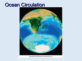
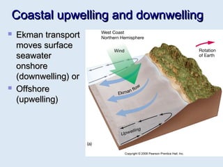
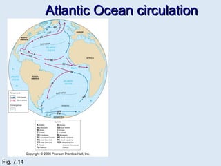
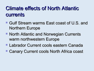
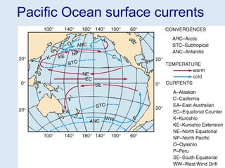
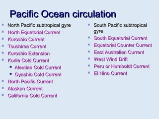
2. Ocean currentsOcean currents
Moving seawaterMoving seawater
Surface ocean currentsSurface ocean currents
Transfer heat from warmer to coolerTransfer heat from warmer to cooler
areasareas
Similar to pattern of major wind beltsSimilar to pattern of major wind belts
Affect coastal climatesAffect coastal climates
AA gyre is a circular spiral form andgyre is a circular spiral form and
it refers to the circular motion ofit refers to the circular motion of
water in all the major oceans. It iswater in all the major oceans. It is
centered in the subtropical highcentered in the subtropical high
pressure regions.pressure regions.
3. Types of ocean currentsTypes of ocean currents
Surface currentsSurface currents
Wind-drivenWind-driven
Primarily horizontal motionPrimarily horizontal motion
Deep currentsDeep currents
Driven by differences in density causedDriven by differences in density caused
by differences in temperature andby differences in temperature and
salinitysalinity
Vertical and horizontal motionsVertical and horizontal motions
4. Types of Ocean CurrentsTypes of Ocean Currents
Generally, one talks about the cold current and the warm current. These twoGenerally, one talks about the cold current and the warm current. These two
terms are relative. Generally, a poleward-moving current is warm asterms are relative. Generally, a poleward-moving current is warm as
compared with general atmospheric temperatures and those of the adjacentcompared with general atmospheric temperatures and those of the adjacent
waters of the ocean. An equatorward-moving current is cool or cold becausewaters of the ocean. An equatorward-moving current is cool or cold because
its temperatures are lower than those of the atmosphere or of adjacentits temperatures are lower than those of the atmosphere or of adjacent
waters.waters.
(i) Drift(i) Drift - The velocity of a drift varies from 16 to 24 km a day. Thus, drifts- The velocity of a drift varies from 16 to 24 km a day. Thus, drifts
are caused by the friction between the winds and the surface water. Itare caused by the friction between the winds and the surface water. It
covers a broad belt in between latitude 35° and 45° in the northerncovers a broad belt in between latitude 35° and 45° in the northern
hemisphere and latitude 30° and 60° in the southern hemisphere.hemisphere and latitude 30° and 60° in the southern hemisphere.
(ii) Current(ii) Current - Current moves more rapidly and more definitely than the- Current moves more rapidly and more definitely than the
drift. A current may have a velocity of 6 or even 8 km an hour.drift. A current may have a velocity of 6 or even 8 km an hour.
(iii) Stream(iii) Stream - Stream is intensified and more definite means its- Stream is intensified and more definite means its
boundaries are clearly discernible and are more definite. lies on the westernboundaries are clearly discernible and are more definite. lies on the western
side, where a cold, south-moving current parallels it on the landward side.side, where a cold, south-moving current parallels it on the landward side.
5. Generalised factors causing -SurfaceGeneralised factors causing -Surface
currentscurrents
wind and its Frictionwind and its Friction
DensityDensity
Atmospheric PressureAtmospheric Pressure
PrecipitationPrecipitation
Melting of GlaciersMelting of Glaciers
Coriolis effectCoriolis effect
TemperatureTemperature
GyresGyres or large circular loops ofor large circular loops of
moving watermoving water
6. Modifying factors causing -SurfaceModifying factors causing -Surface
currentscurrents
Shape of the coastShape of the coast
Seasonal ChangeSeasonal Change
Bottom TopographyBottom Topography
7. Wind its frictionWind its friction
Wind and its frictionWind and its friction – Wind put friction on surface of the oceans is– Wind put friction on surface of the oceans is
induced as a result of the stress which the winds exert on ocean water.induced as a result of the stress which the winds exert on ocean water.
The trade winds blowing from north-east and south-east in the northern andThe trade winds blowing from north-east and south-east in the northern and
southern hemispheres respectively provided stress as a result north andsouthern hemispheres respectively provided stress as a result north and
south equatorial currents are produced. These currents are present in thesouth equatorial currents are produced. These currents are present in the
Atlantic, the Pacific and the Indian Oceans.Atlantic, the Pacific and the Indian Oceans.
In the equatorial regions of all the oceans, the Equatorial Counter CurrentIn the equatorial regions of all the oceans, the Equatorial Counter Current
develops between the north and south equatorial currents to make up thedevelops between the north and south equatorial currents to make up the
water deficiency at the surface. These counter currents flow eastwards.water deficiency at the surface. These counter currents flow eastwards.
As a matter of fact, the necessary energy needed to maintain the circulationAs a matter of fact, the necessary energy needed to maintain the circulation
system of the oceans comes from the planetary wind system.system of the oceans comes from the planetary wind system.
It was found that the currents flow at an angle of 20 to 40° from the directionIt was found that the currents flow at an angle of 20 to 40° from the direction
of the wind. To summarise, the energy needed by ocean currents isof the wind. To summarise, the energy needed by ocean currents is
supplied exclusively by winds, which is putting tangential stress at the seasupplied exclusively by winds, which is putting tangential stress at the sea
surface and this way initiate and maintain ocean currents.surface and this way initiate and maintain ocean currents.
8. Density & AtmosphericDensity & Atmospheric
PressurePressure
DensityDensity - Denser water tends to move downwards, and less dense water- Denser water tends to move downwards, and less dense water
being lighter tends to move upwards.being lighter tends to move upwards.
High temperature leads to lower density and lower temperature results in higher density.High temperature leads to lower density and lower temperature results in higher density.
Salinity also affects density. Higher salinity means higher density, whereas lowerSalinity also affects density. Higher salinity means higher density, whereas lower
salinity results in lower density of sea water.salinity results in lower density of sea water.
Density is controlled by the rate of evaporation also. Rate of evaporation is high,Density is controlled by the rate of evaporation also. Rate of evaporation is high,
as in subtropical High pressure regions, the density increases.as in subtropical High pressure regions, the density increases.
Larger amount of precipitation and the supply of fresh water by the rivers and byLarger amount of precipitation and the supply of fresh water by the rivers and by
the melt-water causes lower the density of sea water.the melt-water causes lower the density of sea water.
Ocean current flows from lower density to higher density ocean waterOcean current flows from lower density to higher density ocean water
Atmospheric pressure -Atmospheric pressure - Because of higher pressure, there is reductionBecause of higher pressure, there is reduction
in the volume of surface water which results in lowering of the sea-level. Onin the volume of surface water which results in lowering of the sea-level. On
the contrary, lower pressure on the sea surface results in raising the waterthe contrary, lower pressure on the sea surface results in raising the water
level and that the water movement starts from the higher water level towardslevel and that the water movement starts from the higher water level towards
the lower level.the lower level.
9. PrecipitationPrecipitation
Precipitation and evaporationPrecipitation and evaporation - Water level in areas with greater- Water level in areas with greater
amount of precipitation is higher than that in areas with lesser amount. Thus,amount of precipitation is higher than that in areas with lesser amount. Thus,
in order to eliminate the difference in water level ocean currents arein order to eliminate the difference in water level ocean currents are
produced.produced.
Besides the difference in the water level, the supply of fresh water results inBesides the difference in the water level, the supply of fresh water results in
the decrease of salinity, which in turn increases level of sea water. Thethe decrease of salinity, which in turn increases level of sea water. The
precipitation, therefore, contributes a lot, directly or indirectly, in the initiationprecipitation, therefore, contributes a lot, directly or indirectly, in the initiation
of ocean currents. The equatorial region for example, receives a largerof ocean currents. The equatorial region for example, receives a larger
amount of precipitation than the mid-latitude regions. That is why oceanamount of precipitation than the mid-latitude regions. That is why ocean
currents invariably flow from the equatorial regions towards the highcurrents invariably flow from the equatorial regions towards the high
latitudes, where the amount of precipitation is much less.latitudes, where the amount of precipitation is much less.
On the contrary, in the subtropical high pressure belt the climatic conditionsOn the contrary, in the subtropical high pressure belt the climatic conditions
permit a much greater rate of evaporation and the amount of precipitation ispermit a much greater rate of evaporation and the amount of precipitation is
much less. Since in this high-pressure region evaporation, exceedsmuch less. Since in this high-pressure region evaporation, exceeds
precipitation, the salinity and density of the sea water are relatively higher.precipitation, the salinity and density of the sea water are relatively higher.
Therefore the surface currents start flowing from the areas with abundantTherefore the surface currents start flowing from the areas with abundant
precipitation to areas with very little precipitation.precipitation to areas with very little precipitation.
10. Melting of Ice & Coriolis forceMelting of Ice & Coriolis force
Melting of IceMelting of Ice - supplies fresh water to oceans so that their level is raised.- supplies fresh water to oceans so that their level is raised.
Melt water reduces the salinity in ocean water. Thus, water movement fromMelt water reduces the salinity in ocean water. Thus, water movement from
regions of high sea level to other regions of relatively lower sea level is quiteregions of high sea level to other regions of relatively lower sea level is quite
natural. The Eastern Greenland Current is initiated due to the supply of meltnatural. The Eastern Greenland Current is initiated due to the supply of melt
water.water.
Coriolis forceCoriolis force – Coriolis force is a function of the latitude. It is maximum– Coriolis force is a function of the latitude. It is maximum
at the poles and minimum at the equator.As Earth rotates on its axis fromat the poles and minimum at the equator.As Earth rotates on its axis from
west to east. It always acts towards the right in the northern hemisphere,west to east. It always acts towards the right in the northern hemisphere,
and left in the southern hemisphere. Thus, under the influence of this force,and left in the southern hemisphere. Thus, under the influence of this force,
the ocean currents in the northern hemisphere tend to turn to their right, andthe ocean currents in the northern hemisphere tend to turn to their right, and
in the southern hemisphere to their left.in the southern hemisphere to their left.
Ekman Spiral -Ekman Spiral - regarding the deflection of ocean currents relative to the windregarding the deflection of ocean currents relative to the wind
direction. Ekman developed the theory called thedirection. Ekman developed the theory called the Ekman Spiral.Ekman Spiral. The theoryThe theory
assumes a homogeneous water column that is set in motion by wind blowingassumes a homogeneous water column that is set in motion by wind blowing
across its suface. In the northern hemisphere the surface current moves in aacross its suface. In the northern hemisphere the surface current moves in a
direction 45° to the right of the wind.direction 45° to the right of the wind.
11. Ekman transportEkman transport
Average movement of seawater underAverage movement of seawater under
influence of windinfluence of wind
9090oo
to right of wind in Northern hemisphereto right of wind in Northern hemisphere
9090oo
to left of wind in Southern hemisphereto left of wind in Southern hemisphere
Fig. 7.7
12. GeostrophicGeostrophic
flowflow Ekman transportEkman transport
piles up waterpiles up water
within subtropicalwithin subtropical
gyresgyres
Surface waterSurface water
flows downhillflows downhill
(gravity) and(gravity) and
Also to the rightAlso to the right
(Coriolis effect)(Coriolis effect)
Balance ofBalance of
downhill and todownhill and to
the right causesthe right causes
geostrophic flowgeostrophic flow
around the “hill”around the “hill”
Fig. 7.8
13. Difference in temperatureDifference in temperature
Difference in temperatureDifference in temperature - variation in the amount of- variation in the amount of
insolation is the main cause of non-uniformity in the rate ofinsolation is the main cause of non-uniformity in the rate of
evaporation in different regions.evaporation in different regions.
In the low latitude regions the amount of insolation received farIn the low latitude regions the amount of insolation received far
exceeds that received in the high latitude regions. But due to theexceeds that received in the high latitude regions. But due to the
greater amount of cloudiness and precipitation, the rate ofgreater amount of cloudiness and precipitation, the rate of
evaporation is much lower. This causes both the salinity andevaporation is much lower. This causes both the salinity and
density of sea water to be relatively lower. Thus, the light anddensity of sea water to be relatively lower. Thus, the light and
warm water from the low latitude region is driven by thewarm water from the low latitude region is driven by the
prevailing winds towards the high latitude regions.prevailing winds towards the high latitude regions.
15. Western intensificationWestern intensification
Top of hill of water displaced toward westTop of hill of water displaced toward west
due to Earth’s rotationdue to Earth’s rotation
Western boundary currents intensifiedWestern boundary currents intensified
FasterFaster
NarrowerNarrower
DeeperDeeper
WarmWarm
16. Eastern Boundary CurrentsEastern Boundary Currents
Eastern side of ocean basinsEastern side of ocean basins
Tend to have the opposite properties ofTend to have the opposite properties of
Western CurrentsWestern Currents
ColdCold
SlowSlow
ShallowShallow
WideWide
17. Ocean currents and climateOcean currents and climate
Warm ocean currents warm air atWarm ocean currents warm air at
coastcoast
Warm, humid airWarm, humid air
Humid climate on adjoining landmassHumid climate on adjoining landmass
Cool ocean currents cool air at coastCool ocean currents cool air at coast
Cool, dry airCool, dry air
Dry climate on adjoining landmassDry climate on adjoining landmass
18. Coastal upwelling and downwellingCoastal upwelling and downwelling
Ekman transportEkman transport
moves surfacemoves surface
seawaterseawater
onshoreonshore
(downwelling) or(downwelling) or
OffshoreOffshore
(upwelling)(upwelling)
19.
20. Atlantic Ocean circulationAtlantic Ocean circulation
North Atlantic Subtropical GyreNorth Atlantic Subtropical Gyre
North Equatorial CurrentNorth Equatorial Current
South Equatorial CurrentSouth Equatorial Current
Florida CurrentFlorida Current
Antilles CurrentAntilles Current
Gulf StreamGulf Stream
North Atlantic DriftNorth Atlantic Drift
North East DriftNorth East Drift
Norwegian CurrentNorwegian Current
Irminger CurrentIrminger Current
East Greenland Cold CurrentEast Greenland Cold Current
Labrador Cold CurrentLabrador Cold Current
South East DriftSouth East Drift
Canary Cold CurrentCanary Cold Current
English ChannelEnglish Channel
Atlantic Equatorial CounterAtlantic Equatorial Counter
South Atlantic Subtropical GyreSouth Atlantic Subtropical Gyre
South Equatorial CurrentSouth Equatorial Current
Brazil CurrentBrazil Current
Falkland CurrentFalkland Current
South Atlantic Drift ( West WindSouth Atlantic Drift ( West Wind
DriftDrift
Benguel Cold CurrentBenguel Cold Current
23. Climate effects of North AtlanticClimate effects of North Atlantic
currentscurrents
Gulf Stream warms East coast of U.S. andGulf Stream warms East coast of U.S. and
Northern EuropeNorthern Europe
North Atlantic and Norwegian CurrentsNorth Atlantic and Norwegian Currents
warm northwestern Europewarm northwestern Europe
Labrador Current cools eastern CanadaLabrador Current cools eastern Canada
Canary Current cools North Africa coastCanary Current cools North Africa coast
25. Pacific Ocean circulationPacific Ocean circulation
North Pacific subtropical gyreNorth Pacific subtropical gyre
North Equatorial CurrentNorth Equatorial Current
Kuroshio CurrentKuroshio Current
Tsushima CurrentTsushima Current
Kuroshio ExtensionKuroshio Extension
Kurile Cold CurrentKurile Cold Current
Aleutian Cold CurrentAleutian Cold Current
Oyashio Cold CurrentOyashio Cold Current
North Pacific CurrentNorth Pacific Current
Alaskan CurrentAlaskan Current
California Cold CurrentCalifornia Cold Current
South Pacific subtropicalSouth Pacific subtropical
gyregyre
South Equatorial CurrentSouth Equatorial Current
Equatorial Counter CurrentEquatorial Counter Current
East Australian CurrentEast Australian Current
West Wind DriftWest Wind Drift
Peru or Humboldt CurrentPeru or Humboldt Current
El Nino CurrentEl Nino Current
26. SummerSummer
South West MonsoonSouth West Monsoon
CurrentCurrent
Somali Cold CurrentSomali Cold Current
South Equatorial CurrentSouth Equatorial Current
Madagascar CurrentMadagascar Current
Mozambique ChannelMozambique Channel
AgulhasAgulhas
West Wind DriftWest Wind Drift
West Australian ColdWest Australian Cold
CurrentCurrent
South Indian SubtropicalSouth Indian Subtropical
GyreGyre
Indian Ocean circulationIndian Ocean circulation
WinterWinter
North East MonsoonNorth East Monsoon
CurrentCurrent
Equatorial CountercurrentEquatorial Countercurrent
South Equatorial CurrentSouth Equatorial Current
Madagascar CurrentMadagascar Current
Mozambique ChannelMozambique Channel
AgulhasAgulhas
West Wind DriftWest Wind Drift
West Australian ColdWest Australian Cold
CurrentCurrent
South Indian SubtropicalSouth Indian Subtropical
GyreGyre
28. Atmospheric and oceanicAtmospheric and oceanic
disturbances in Pacific Oceandisturbances in Pacific Ocean
Normal conditionsNormal conditions
Air pressure across equatorial Pacific isAir pressure across equatorial Pacific is
higher in eastern Pacifichigher in eastern Pacific
Strong southeast trade windsStrong southeast trade winds
Pacific warm pool on western sidePacific warm pool on western side
Thermocline deeper on western sideThermocline deeper on western side
Upwelling off the coast of PeruUpwelling off the coast of Peru