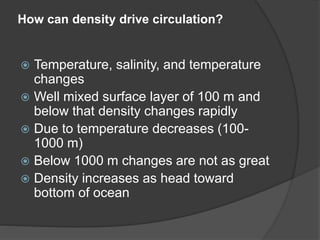
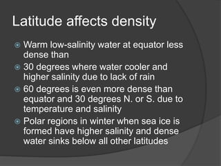
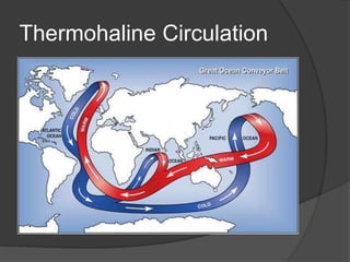
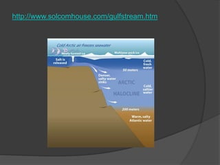
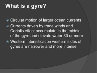
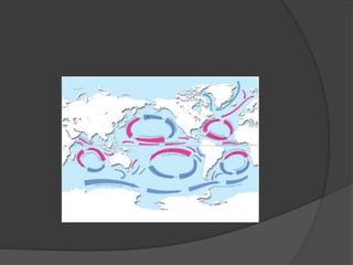
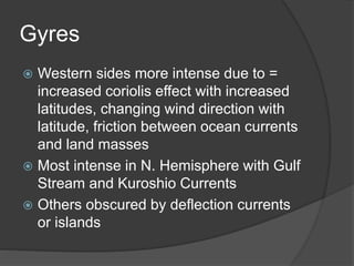
Chapter 8 and 9
How can density drive circulation?
 Temperature, salinity, and temperature
changes
 Well mixed surface layer of 100 m and
below that density changes rapidly
 Due to temperature decreases (100-
1000 m)
 Below 1000 m changes are not as great
 Density increases as head toward
bottom of ocean
Latitude affects density
 Warm low-salinity water at equator less
dense than
 30 degrees where water cooler and
higher salinity due to lack of rain
 60 degrees is even more dense than
equator and 30 degrees N. or S. due to
temperature and salinity
 Polar regions in winter when sea ice is
formed have higher salinity and dense
water sinks below all other latitudes
What is thermohaline circulation? How is it
driven?
 Density driven vertical circulation
controlled by temperature and salinity
 If more dense water on top then initiates
downwelling
 While less dense water rises called
upwelling = overturn
Thermohaline Circulation
NASA Imagery
Thermohaline Circulation
 If same density in water column then
waves and wind can mix easily
 If density changes with depth then does not
over turn and more stable
 Large scale thermohaline circulation
system ensures eventual mixing from top
to bottom
 Seasonal changes in temperature more
important than seasonal changes in salinity
in altering density in open oceans
What are the layers dividing?
 Temperature, salinity, and density
 North Atlantic Ocean Deep Water = where converge at 60
degrees N.
 What is the result of this convergence?
 34 0/00 and 2-4 degrees C
 Dense water sinks and moves south
 Above very salty warm water is trapped by gyre
movement
 Between these layers is an intermediate salinity and
temperature
 Mediterranean water finds own layer as empties into
ocean
 Antarctic Intermediate water is warmer and less salty than
the Atlantic Ocean Deep Water
Subsurface layers in Atlantic
http://oceano.iim.csic.es/co2group/carboocean.html
Sea Ice forms Antarctic Bottom water and is the densest water in the
ocean
 Sea Ice forms Antarctic Bottom water and
is the densest water in the ocean
 This water moves northward and under the
Atlantic Deep water
 Trapped on the West side of the Mid-
Atlantic Ridge system
 Moves as far North as equator
 North Atlantic Deep water splits as reaches
surface and northward part becomes South
Atlantic surface water and Antarctic
Intermediate water and moves southward
What differences do you notice between the
different oceans?
 Pacific Ocean colder less salty water
 Atlantic warmer and more salty
 The Arctic Ocean = density controlled by salinity and not
temperature
 Combines with Gulf Stream water to form North Atlantic
Deep water
 The Pacific Ocean = Conditions uniform below 2000 m
 N. Pacific isolated from the Arctic Ocean
 Western side cold Bering Sea water converges with
Equatorial currents produces a small volume that sinks to
mid depths
 Indian Ocean = Antarctic circumpolar water mainly and
small amounts of Antarctic Intermediate water and warm
salty surface water
http://www.solcomhouse.com/gulfstream.htm
What is a gyre?
 Circular motion of larger ocean currents
 Currents driven by trade winds and
Coriolis effect accumulate in the middle
of the gyre and elevate water 3ft or more
 Western Intensification western sides of
gyres are narrower and more intense
Gyres
 Western sides more intense due to =
increased coriolis effect with increased
latitudes, changing wind direction with
latitude, friction between ocean currents
and land masses
 Most intense in N. Hemisphere with Gulf
Stream and Kuroshio Currents
 Others obscured by deflection currents
or islands
Surface currents driven by?
 The Pacific Ocean
 Trade winds move water away from Central
& S. Am. and push up against Asia
 Westerlies move water away from Asia and
push up against west coast of N. Am.
 Water that accumulates must move
towards water that has been removed
 Creating CA and Kuroshio currents on E.
and W. sides
 Note other minor currents that feed into the
N. Pacific Gyre (i.e. Oyashio
 Gyres are on 5 degrees either side of
equator and Equatorial Countercurrent
runs in the opposite direction (i.e. helps
return surface water that has
accumulated against Asia)
 Charts can show surface flows over
specific time but do not reflect
 El nino and la nina
The Atlantic Ocean
 Gulf Stream fed by both N. Equatorial and Gulf
currents
 Speeds up to 5ft per second
 Volume flow 500x the Amazon River
 FL current may exceed Gulf Stream in speed
 N. Atlantic Gyre isolates Sargasso Sea
 1000 m deep of clear warm surface water
 Defined by the currents and N. Atlantic Ridge
 Sargasso seaweed or algae provides rich
community in a dessert of open ocean (with
down welling = nutrient poor)
http://infranetlab.org/blog/wpcontent/uploads/2008/12/north_pacific_gyre
_world_map.png
 S. Atlantic Ocean trade winds move
water to west but Brazil splits the S.
Equatorial Current.
 Most goes into Caribbean Sea and Gulf
 Why is this important to the U.S.?
Cousteau and the Amazon
 http://www.imdb.com/video/cbs/vi41306
03545/
 The Amazon feeds out into the ocean
and flows North past the Caribbean
Islands and into the Gulf of Mexico
 What goes on in the Amazon affects us!
The Arctic Ocean
 Large clockwise gyre
 Some water from Pacific through Bering
Strait
 Some water from Atlantic west of
Spitsbergen
 West Greenland water flows S. and joins
Labrador Current
Indian Ocean
 The Indian Ocean
 S. Hemisphere ocean
 Smallest Gyre
 N. Equatorial Current strengthened by
northeast trade winds during dry season
 Wet monsoon season winds strengthen the
Equatorial Countercurrent and reduce N.
Equatorial
 This seasonal shift unlike in Atlantic or
Pacific gyres
Convergent vs. Divergent
 What is the difference between
convergence and divergence
currents?
 Convergence = combining of currents
where downwelling occurring
 Divergence = currents upwell and move
away from each other
Convergence Currents
 Subtropical convergences at 30-40
degrees N. and S.
 Arctic and Antarctic convergences at 50
degrees N. and S.
 Three major ocean divergence zones =
two tropical and one Antarctic
Convergence brings oxygen rich surface
water to depths and
Divergence brings nutrients up
from the deeper waters
 Mixing of waters of different geographic
regions mix with these currents
Thermohaline and wind driven currents are
closely related
 Changing sea levels, moving continents,
and shapes of ocean basins have changed
these currents
 Climate change also has altered locations
and role of upwelling and down welling
 Surface currents driven by winds and
thermohaline help redistribute heat, salinity,
and dissolved gases
Coastal Upwelling and
Downwelling
 Why are these area important?
 Productive areas for nutrients and fish
 Trade winds on Western sides of
continents create continual upwelling
 Seasonal upwelling and downwelling
occurs along coast lines
 Lack of land in S. Hemisphere has less
of this affect
Northwest U.S.
 From S. CA to Vancouver Island
Southerly winds in winter and Northerly
in summer and thus changing Ekman
transport of water
 Net result is upwelling in the summer
and downwelling in the winter
http://www.cop.noaa.gov/stressors/climatechange/current/fact-
globecpne.html
 What is the Ekman Spiral and Ekman
Transport?
 Deeper water moves more slowly with
greater deflection and water at the
bottom moves in the opposite direction
(i.e. spiral motion)
https://www.e-education.psu.edu/earth540/content/c4_p3.html
Eddies
 Where are they found and how are they
created?
 Pockets of cold or warm water moving in a
circular motion spinning off major current
(i.e. Gulf Stream)
 Current meanders and creates these
pockets on either side
 Eddies occur throughout the ocean at all
depths
 Each eddy has own chemistry until it mixes
with surrounding water
http://www.liv.ac.uk/physocean/research.html
Fish and other marine life use Eddies to escape
predators in the open ocean! (Gulf Stream below)
How are currents measured?
 Following the water with die, pictures or
a machine
 Also measure speed and direction as
passes a fixed point
 Satellite images
 Buoys
 Doppler
 Could be used on the surface or
underwater anchored to buoy
Image of acoustic doppler being used in Greenland
http://www.whoi.edu/page.do?pid=10897&i=8201&x=247
 Newer electronic meters emit narrow
frequency sound beams in all four
directions
 Echo frequency is related to water speed
and is known as the Doppler Effect
 In order to emit frequency in all four
directions, meter is checked against
internal compass
 Data can be stored or transmitted to ship or
surface buoy
http://www.pmel.noaa.gov/tao/proj_over/mooring.sht
ml
How can oceans provide energy?
 Through heat and currents
 Oceans have large heat capacity
 Ocean Thermal Energy Conversion
(OTEC) works with temperature
differences between surface and up to
1000 m
http://www.phoenixprojectfoundation.us/
Energy from Heat
 Two types: 1) Closed system uses
contained fluid such as ammonia or
Freon with low boiling point or
 2) Open system which directly converts
sea water to steam
 Closed system = warm water passes
over evaporator chamber that contains
fluid. Working fluid is vaporized by heat
from sea water. As vapor heats up it
builds up pressure to spin turbine which
in turn generates power. After fluid has
been heated up then it is returned to
liquid state to start cycle all over again.
Closed System
http://www.nrel.gov/otec/electricity.html
 Open system = requires large quantities
of warm water and must be condensed
by using fresh water.
 Requires at least 20 degrees C
difference between surface and depth in
order to generate more power than is
used
Open System
http://www.nrel.gov/otec/electricity.html
Hybrid System
http://www.nrel.gov/otec/electricity.html
 Latitudes of 25 degrees N. or S. would
be best location for plants due to
average sea temperature of 22 degrees
C
 Plant/Lab in Hawaii (NELHA) closed
after seven years in use due to cost
being 10x that of oil or coal
 Now experimenting with bringing cold
water from depths and producing fresh
water with lab.
http://nelha.org/
Other sources of energy in the oceans…
http://www.phoenixprojectfoundation.us/

Current slideshow

  • 1.
  • 2.
    How can densitydrive circulation?  Temperature, salinity, and temperature changes  Well mixed surface layer of 100 m and below that density changes rapidly  Due to temperature decreases (100- 1000 m)  Below 1000 m changes are not as great  Density increases as head toward bottom of ocean
  • 3.
    Latitude affects density Warm low-salinity water at equator less dense than  30 degrees where water cooler and higher salinity due to lack of rain  60 degrees is even more dense than equator and 30 degrees N. or S. due to temperature and salinity  Polar regions in winter when sea ice is formed have higher salinity and dense water sinks below all other latitudes
  • 4.
    What is thermohalinecirculation? How is it driven?  Density driven vertical circulation controlled by temperature and salinity  If more dense water on top then initiates downwelling  While less dense water rises called upwelling = overturn
  • 5.
  • 6.
  • 7.
    Thermohaline Circulation  Ifsame density in water column then waves and wind can mix easily  If density changes with depth then does not over turn and more stable  Large scale thermohaline circulation system ensures eventual mixing from top to bottom  Seasonal changes in temperature more important than seasonal changes in salinity in altering density in open oceans
  • 8.
    What are thelayers dividing?  Temperature, salinity, and density  North Atlantic Ocean Deep Water = where converge at 60 degrees N.  What is the result of this convergence?  34 0/00 and 2-4 degrees C  Dense water sinks and moves south  Above very salty warm water is trapped by gyre movement  Between these layers is an intermediate salinity and temperature  Mediterranean water finds own layer as empties into ocean  Antarctic Intermediate water is warmer and less salty than the Atlantic Ocean Deep Water
  • 9.
    Subsurface layers inAtlantic http://oceano.iim.csic.es/co2group/carboocean.html
  • 10.
    Sea Ice formsAntarctic Bottom water and is the densest water in the ocean  Sea Ice forms Antarctic Bottom water and is the densest water in the ocean  This water moves northward and under the Atlantic Deep water  Trapped on the West side of the Mid- Atlantic Ridge system  Moves as far North as equator  North Atlantic Deep water splits as reaches surface and northward part becomes South Atlantic surface water and Antarctic Intermediate water and moves southward
  • 11.
    What differences doyou notice between the different oceans?  Pacific Ocean colder less salty water  Atlantic warmer and more salty  The Arctic Ocean = density controlled by salinity and not temperature  Combines with Gulf Stream water to form North Atlantic Deep water  The Pacific Ocean = Conditions uniform below 2000 m  N. Pacific isolated from the Arctic Ocean  Western side cold Bering Sea water converges with Equatorial currents produces a small volume that sinks to mid depths  Indian Ocean = Antarctic circumpolar water mainly and small amounts of Antarctic Intermediate water and warm salty surface water
  • 12.
  • 13.
    What is agyre?  Circular motion of larger ocean currents  Currents driven by trade winds and Coriolis effect accumulate in the middle of the gyre and elevate water 3ft or more  Western Intensification western sides of gyres are narrower and more intense
  • 15.
    Gyres  Western sidesmore intense due to = increased coriolis effect with increased latitudes, changing wind direction with latitude, friction between ocean currents and land masses  Most intense in N. Hemisphere with Gulf Stream and Kuroshio Currents  Others obscured by deflection currents or islands
  • 16.
    Surface currents drivenby?  The Pacific Ocean  Trade winds move water away from Central & S. Am. and push up against Asia  Westerlies move water away from Asia and push up against west coast of N. Am.  Water that accumulates must move towards water that has been removed  Creating CA and Kuroshio currents on E. and W. sides  Note other minor currents that feed into the N. Pacific Gyre (i.e. Oyashio
  • 17.
     Gyres areon 5 degrees either side of equator and Equatorial Countercurrent runs in the opposite direction (i.e. helps return surface water that has accumulated against Asia)  Charts can show surface flows over specific time but do not reflect  El nino and la nina
  • 18.
    The Atlantic Ocean Gulf Stream fed by both N. Equatorial and Gulf currents  Speeds up to 5ft per second  Volume flow 500x the Amazon River  FL current may exceed Gulf Stream in speed  N. Atlantic Gyre isolates Sargasso Sea  1000 m deep of clear warm surface water  Defined by the currents and N. Atlantic Ridge  Sargasso seaweed or algae provides rich community in a dessert of open ocean (with down welling = nutrient poor)
  • 19.
  • 20.
     S. AtlanticOcean trade winds move water to west but Brazil splits the S. Equatorial Current.  Most goes into Caribbean Sea and Gulf  Why is this important to the U.S.?
  • 21.
    Cousteau and theAmazon  http://www.imdb.com/video/cbs/vi41306 03545/  The Amazon feeds out into the ocean and flows North past the Caribbean Islands and into the Gulf of Mexico  What goes on in the Amazon affects us!
  • 22.
    The Arctic Ocean Large clockwise gyre  Some water from Pacific through Bering Strait  Some water from Atlantic west of Spitsbergen  West Greenland water flows S. and joins Labrador Current
  • 23.
    Indian Ocean  TheIndian Ocean  S. Hemisphere ocean  Smallest Gyre  N. Equatorial Current strengthened by northeast trade winds during dry season  Wet monsoon season winds strengthen the Equatorial Countercurrent and reduce N. Equatorial  This seasonal shift unlike in Atlantic or Pacific gyres
  • 24.
    Convergent vs. Divergent What is the difference between convergence and divergence currents?  Convergence = combining of currents where downwelling occurring  Divergence = currents upwell and move away from each other
  • 25.
    Convergence Currents  Subtropicalconvergences at 30-40 degrees N. and S.  Arctic and Antarctic convergences at 50 degrees N. and S.  Three major ocean divergence zones = two tropical and one Antarctic Convergence brings oxygen rich surface water to depths and
  • 26.
    Divergence brings nutrientsup from the deeper waters  Mixing of waters of different geographic regions mix with these currents Thermohaline and wind driven currents are closely related  Changing sea levels, moving continents, and shapes of ocean basins have changed these currents  Climate change also has altered locations and role of upwelling and down welling  Surface currents driven by winds and thermohaline help redistribute heat, salinity, and dissolved gases
  • 27.
    Coastal Upwelling and Downwelling Why are these area important?  Productive areas for nutrients and fish  Trade winds on Western sides of continents create continual upwelling  Seasonal upwelling and downwelling occurs along coast lines  Lack of land in S. Hemisphere has less of this affect
  • 28.
    Northwest U.S.  FromS. CA to Vancouver Island Southerly winds in winter and Northerly in summer and thus changing Ekman transport of water  Net result is upwelling in the summer and downwelling in the winter
  • 29.
  • 30.
     What isthe Ekman Spiral and Ekman Transport?  Deeper water moves more slowly with greater deflection and water at the bottom moves in the opposite direction (i.e. spiral motion)
  • 31.
  • 32.
    Eddies  Where arethey found and how are they created?  Pockets of cold or warm water moving in a circular motion spinning off major current (i.e. Gulf Stream)  Current meanders and creates these pockets on either side  Eddies occur throughout the ocean at all depths  Each eddy has own chemistry until it mixes with surrounding water
  • 33.
  • 34.
    Fish and othermarine life use Eddies to escape predators in the open ocean! (Gulf Stream below)
  • 35.
    How are currentsmeasured?  Following the water with die, pictures or a machine  Also measure speed and direction as passes a fixed point  Satellite images  Buoys  Doppler  Could be used on the surface or underwater anchored to buoy
  • 36.
    Image of acousticdoppler being used in Greenland http://www.whoi.edu/page.do?pid=10897&i=8201&x=247
  • 37.
     Newer electronicmeters emit narrow frequency sound beams in all four directions  Echo frequency is related to water speed and is known as the Doppler Effect  In order to emit frequency in all four directions, meter is checked against internal compass  Data can be stored or transmitted to ship or surface buoy
  • 38.
  • 39.
    How can oceansprovide energy?  Through heat and currents  Oceans have large heat capacity  Ocean Thermal Energy Conversion (OTEC) works with temperature differences between surface and up to 1000 m
  • 40.
  • 41.
    Energy from Heat Two types: 1) Closed system uses contained fluid such as ammonia or Freon with low boiling point or  2) Open system which directly converts sea water to steam
  • 42.
     Closed system= warm water passes over evaporator chamber that contains fluid. Working fluid is vaporized by heat from sea water. As vapor heats up it builds up pressure to spin turbine which in turn generates power. After fluid has been heated up then it is returned to liquid state to start cycle all over again.
  • 43.
  • 44.
     Open system= requires large quantities of warm water and must be condensed by using fresh water.  Requires at least 20 degrees C difference between surface and depth in order to generate more power than is used
  • 45.
  • 46.
  • 47.
     Latitudes of25 degrees N. or S. would be best location for plants due to average sea temperature of 22 degrees C  Plant/Lab in Hawaii (NELHA) closed after seven years in use due to cost being 10x that of oil or coal  Now experimenting with bringing cold water from depths and producing fresh water with lab.
  • 48.
  • 49.
    Other sources ofenergy in the oceans… http://www.phoenixprojectfoundation.us/