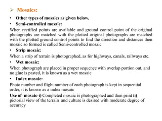
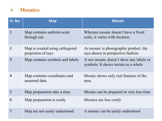
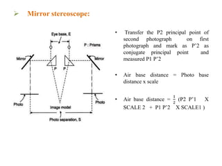
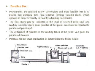
SlideShare a Scribd company logo
Advance Surveying
Aerial Photogrammetry
by
Prof. Rajguru R.S.
Civil Engineering Department
(rajgururajeshcivil@sanjivani.org.in)
Sanjivani College of Engineering,
Kopargaon, MH, India
 Lecture Outline
 Mosaic
 Mirror stereoscope
 Parallax Bar
 Mosaic:
• Mosaic
Series or the assembly of overlapping aerial photograph is called as mosaic. It
is prepared by cutting and removing the common area in one of the 2 adjacent
photographs taken during the aerial photography, then joining them together.
Compared to photograph a mosaic represents large amount of area.
• Mosaics are mainly classified into 2 types as given below.
Controlled Mosaic
Controlled mosaics contain ground control points. These points are marked at
various locations on the photograph and are transferred into the mosaic while
preparing. These ground control points help in understanding or estimating the
distance between various locations on the mosaic.
Uncontrolled Mosaic
Uncontrolled mosaics doesn’t contain any control points. The photographs are
simply joined together for the sake of continuity only. It is normally used for
understanding or visually inspecting various features of the terrain. Measures
cannot be made from this type of uncontrolled mosaics.
 Mosaics:
• Other types of mosaics as given below.
• Semi-controlled mosaic:
When rectified points are available and ground control point of the original
photographs are matched with the plotted original photographs are matched
with the plotted ground control points to find the direction and distances then
mosaic so formed is called Semi-controlled mosaic
• Strip mosaic:
When a strip of terrain is photographed, as for highways, canals, railways etc.
• Wet mosaic:
When photograph are placed in proper sequence with overlap portion out, and
no glue is pasted, it is known as a wet mosaic
• Index mosaic:
Photo number and flight number of each photograph is kept in sequential
order, it is known as a index mosaic
Use of mosaic-i) Completed mosaic is photographed and then print ii)
pictorial view of the terrain and culture is desired with moderate degree of
accuracy
 Mosaics:
Sr. No. Map Mosaic
1 Map contains uniform scale
through out.
Whereas mosaic doesn’t have a fixed
scale, it varies with location.
2 Map is created using orthogonal
projection of rays
As mosaic is photographic product, the
rays drawn in perspective fashion
3 Map contains symbols and labels. A raw mosaic doesn’t show any labels or
symbols. It shows terrain as a whole
4 Map contains coordinates and
assumed data.
Mosaic shows only real features of the
area.
5 Map preparation take a time Mosaic can be prepared in very less time
6 Map preparation is costly Mosaics are less costly
7 Map are not easily understood A mosaic can be easily understood
 Mirror stereoscope:
• Arrange the selected pair of photos in such a way that the shadows
on them generally appear to fall toward the viewer. It is also
desirable that the light source enters the side away from the observer
during the study of the photographs
• Place the pair of photographs on a flat surface so that the detail on
one photograph is directly over the same detail on the other
photograph
• Place the stereoscope over the photographs so that the left lens is
over the left photograph and the right lens is over the right
photograph
• Transfer the P1 principal point of first photograph on second
photograph and mark as P’1 as conjugate principal point and
measured P2 P’1
 Mirror stereoscope:
• Transfer the P2 principal point of
second photograph on first
photograph and mark as P’2 as
conjugate principal point and
measured P1 P’2
• Air base distance = Photo base
distance x scale
• Air base distance =
1
2
(P2 P’1 X
SCALE 2 + P1 P’2 X SCALE1 )
 Parallax Bar:
• Photographs are adjusted below stereoscope and then parallax bar is so
placed that graticule dots fuse together forming floating mark, which
appears to move vertically or float by adjusting micrometer.
• The float mark can be adjusted at the level of selected point say1 and
reading is noted, which gives parallax at this point. Procedure is repeated to
parallax of point say2
• The difference of parallax in the reading taken at the point1 &2 gives the
parallax difference
• Parallax bar has great application in determining the flying height
 Parallax Bar:
• Δh =
(H−h)
2
ΔP
ΔP(H−h)+ 𝑏 𝑚H
• h = Elevation of lower point
• H = altitude above m.s.l.
• Δh = Difference in height
• 𝑏𝑚 = Mean principal base
• ΔP= Difference in parallax between two point
Approximate formula, when ΔP is very small h is also small
• dh=
(H−h)
2
𝑏 𝑚H
ΔP
THANK YOU

More Related Content

What's hot

10-Image rectification and restoration.ppt
10-Image rectification and restoration.ppt10-Image rectification and restoration.ppt
10-Image rectification and restoration.ppt
AJAYMALIK97
 
Photogrammetry 1.
Photogrammetry 1.Photogrammetry 1.
Photogrammetry 1.
Naveen Kumar
 
Stereoscopic vision
Stereoscopic visionStereoscopic vision
Geometry and types of aerial photographs
Geometry and types of aerial photographsGeometry and types of aerial photographs
Geometry and types of aerial photographsPooja Kumari
 
Stereoscopic parallax
Stereoscopic parallaxStereoscopic parallax
Stereoscopic parallax
Mr Amol Ghogare
 
Introduction to aerial photography and photogrammetry.ppt
Introduction to aerial photography and photogrammetry.pptIntroduction to aerial photography and photogrammetry.ppt
Introduction to aerial photography and photogrammetry.ppt
srinivas2036
 
BASIC CONCEPTS OF PHOTOGRAMMETRY
BASIC CONCEPTS OF PHOTOGRAMMETRYBASIC CONCEPTS OF PHOTOGRAMMETRY
BASIC CONCEPTS OF PHOTOGRAMMETRY
Namitha M R
 
Aerial photogrammetry ppt 2
Aerial photogrammetry ppt 2Aerial photogrammetry ppt 2
Aerial photogrammetry ppt 2
Mr Amol Ghogare
 
Aerial photography- Concept and Terminologies
Aerial photography- Concept and Terminologies Aerial photography- Concept and Terminologies
Aerial photography- Concept and Terminologies
UTTIYACHATTOPADHYAY2
 
Remote Sensing Platforms and Sensors
Remote Sensing Platforms and SensorsRemote Sensing Platforms and Sensors
Remote Sensing Platforms and Sensors
Uday kumar Devalla
 
Introduction of photogrammetry
Introduction of photogrammetryIntroduction of photogrammetry
Introduction of photogrammetry
Jayantha Samarasinghe
 
Photogrammetry- Surveying
Photogrammetry- SurveyingPhotogrammetry- Surveying
Photogrammetry- SurveyingGokul Saud
 
Aerial photographs and their interpretation
Aerial photographs and their interpretationAerial photographs and their interpretation
Aerial photographs and their interpretationSumant Diwakar
 
Height measurement of aerial photograph
Height measurement of aerial photographHeight measurement of aerial photograph
Height measurement of aerial photograph
vidyasagar university
 
Relief displacement
Relief displacementRelief displacement
Relief displacement
Mr Amol Ghogare
 
Lecture 1-aerial photogrammetry
Lecture 1-aerial photogrammetryLecture 1-aerial photogrammetry
Lecture 1-aerial photogrammetry
Vidhi Khokhani
 
1 2 aerial photography
1 2 aerial photography1 2 aerial photography
1 2 aerial photography
mayasubodh22
 
Distortions and displacement on aerial photograph
Distortions and displacement on aerial photographDistortions and displacement on aerial photograph
Distortions and displacement on aerial photograph
chandan00781
 
Digital Elevation Model (DEM)
Digital Elevation Model (DEM)Digital Elevation Model (DEM)
Digital Elevation Model (DEM)
Malla Reddy University
 
Aerial photography abraham thomas
Aerial photography abraham thomasAerial photography abraham thomas
Aerial photography abraham thomasSumant Diwakar
 

What's hot (20)

10-Image rectification and restoration.ppt
10-Image rectification and restoration.ppt10-Image rectification and restoration.ppt
10-Image rectification and restoration.ppt
 
Photogrammetry 1.
Photogrammetry 1.Photogrammetry 1.
Photogrammetry 1.
 
Stereoscopic vision
Stereoscopic visionStereoscopic vision
Stereoscopic vision
 
Geometry and types of aerial photographs
Geometry and types of aerial photographsGeometry and types of aerial photographs
Geometry and types of aerial photographs
 
Stereoscopic parallax
Stereoscopic parallaxStereoscopic parallax
Stereoscopic parallax
 
Introduction to aerial photography and photogrammetry.ppt
Introduction to aerial photography and photogrammetry.pptIntroduction to aerial photography and photogrammetry.ppt
Introduction to aerial photography and photogrammetry.ppt
 
BASIC CONCEPTS OF PHOTOGRAMMETRY
BASIC CONCEPTS OF PHOTOGRAMMETRYBASIC CONCEPTS OF PHOTOGRAMMETRY
BASIC CONCEPTS OF PHOTOGRAMMETRY
 
Aerial photogrammetry ppt 2
Aerial photogrammetry ppt 2Aerial photogrammetry ppt 2
Aerial photogrammetry ppt 2
 
Aerial photography- Concept and Terminologies
Aerial photography- Concept and Terminologies Aerial photography- Concept and Terminologies
Aerial photography- Concept and Terminologies
 
Remote Sensing Platforms and Sensors
Remote Sensing Platforms and SensorsRemote Sensing Platforms and Sensors
Remote Sensing Platforms and Sensors
 
Introduction of photogrammetry
Introduction of photogrammetryIntroduction of photogrammetry
Introduction of photogrammetry
 
Photogrammetry- Surveying
Photogrammetry- SurveyingPhotogrammetry- Surveying
Photogrammetry- Surveying
 
Aerial photographs and their interpretation
Aerial photographs and their interpretationAerial photographs and their interpretation
Aerial photographs and their interpretation
 
Height measurement of aerial photograph
Height measurement of aerial photographHeight measurement of aerial photograph
Height measurement of aerial photograph
 
Relief displacement
Relief displacementRelief displacement
Relief displacement
 
Lecture 1-aerial photogrammetry
Lecture 1-aerial photogrammetryLecture 1-aerial photogrammetry
Lecture 1-aerial photogrammetry
 
1 2 aerial photography
1 2 aerial photography1 2 aerial photography
1 2 aerial photography
 
Distortions and displacement on aerial photograph
Distortions and displacement on aerial photographDistortions and displacement on aerial photograph
Distortions and displacement on aerial photograph
 
Digital Elevation Model (DEM)
Digital Elevation Model (DEM)Digital Elevation Model (DEM)
Digital Elevation Model (DEM)
 
Aerial photography abraham thomas
Aerial photography abraham thomasAerial photography abraham thomas
Aerial photography abraham thomas
 

Similar to Aerial photogrammetry 05

Close range Photogrammeetry
Close range PhotogrammeetryClose range Photogrammeetry
Close range Photogrammeetrychinmay khadke
 
PHOTOGRAMETRY SURVEY
PHOTOGRAMETRY SURVEYPHOTOGRAMETRY SURVEY
PHOTOGRAMETRY SURVEY
BZU university Multan
 
photogrammetry surveying.pptx.pdf
photogrammetry surveying.pptx.pdfphotogrammetry surveying.pptx.pdf
photogrammetry surveying.pptx.pdf
PrakashBudha3
 
Aerial Photogrammetry
Aerial Photogrammetry Aerial Photogrammetry
Aerial Photogrammetry
Mujeeb Muji
 
Photogrammetry.pdf
Photogrammetry.pdfPhotogrammetry.pdf
Photogrammetry.pdf
BSuresh26
 
Photogrammetry for civil engineering,land survey
Photogrammetry for civil engineering,land surveyPhotogrammetry for civil engineering,land survey
Photogrammetry for civil engineering,land survey
martinmutwiri875
 
Tool maker microscope
Tool maker microscopeTool maker microscope
Auto-collimator
Auto-collimatorAuto-collimator
Auto-collimator
VamsikrishnaMajeti
 
Geometry of Aerial Photographs.pdf
Geometry of Aerial Photographs.pdfGeometry of Aerial Photographs.pdf
Geometry of Aerial Photographs.pdf
kunedzimwefrancisca
 
OPTICAL MICROSCOPY AND COORDINATE MEASURING MACHINE
OPTICAL MICROSCOPY AND COORDINATE MEASURING MACHINE OPTICAL MICROSCOPY AND COORDINATE MEASURING MACHINE
OPTICAL MICROSCOPY AND COORDINATE MEASURING MACHINE
sangeetkhule
 
Photogrammetry1
Photogrammetry1Photogrammetry1
Photogrammetry1
Sudhir Jagtap
 
Computer Vision panoramas
Computer Vision  panoramasComputer Vision  panoramas
Computer Vision panoramas
Wael Badawy
 
Geometry and Projection of Aerial Photograph
Geometry and Projection of Aerial PhotographGeometry and Projection of Aerial Photograph
Geometry and Projection of Aerial Photograph
ShavnamMehta
 
PHOTOGRAMMETIC SURVEYING
PHOTOGRAMMETIC SURVEYING PHOTOGRAMMETIC SURVEYING
PHOTOGRAMMETIC SURVEYING
ADCET, Ashta
 
Lenses
LensesLenses
Surveying ii module iii class 1,2
Surveying ii module iii class 1,2Surveying ii module iii class 1,2
Surveying ii module iii class 1,2
SHAMJITH KM
 
Optical measuring instruments
Optical measuring instrumentsOptical measuring instruments
Optical measuring instruments
nmahi96
 
aberrations
aberrations aberrations
aberrations
Saurabh Bhargava
 
chapter36-OPTICS AND INSTURMENTS-NEW.ppt
chapter36-OPTICS AND INSTURMENTS-NEW.pptchapter36-OPTICS AND INSTURMENTS-NEW.ppt
chapter36-OPTICS AND INSTURMENTS-NEW.ppt
EmadElsehly
 
Confocal laser scanning microscopy
Confocal laser scanning microscopyConfocal laser scanning microscopy
Confocal laser scanning microscopy
Baskar Selvam
 

Similar to Aerial photogrammetry 05 (20)

Close range Photogrammeetry
Close range PhotogrammeetryClose range Photogrammeetry
Close range Photogrammeetry
 
PHOTOGRAMETRY SURVEY
PHOTOGRAMETRY SURVEYPHOTOGRAMETRY SURVEY
PHOTOGRAMETRY SURVEY
 
photogrammetry surveying.pptx.pdf
photogrammetry surveying.pptx.pdfphotogrammetry surveying.pptx.pdf
photogrammetry surveying.pptx.pdf
 
Aerial Photogrammetry
Aerial Photogrammetry Aerial Photogrammetry
Aerial Photogrammetry
 
Photogrammetry.pdf
Photogrammetry.pdfPhotogrammetry.pdf
Photogrammetry.pdf
 
Photogrammetry for civil engineering,land survey
Photogrammetry for civil engineering,land surveyPhotogrammetry for civil engineering,land survey
Photogrammetry for civil engineering,land survey
 
Tool maker microscope
Tool maker microscopeTool maker microscope
Tool maker microscope
 
Auto-collimator
Auto-collimatorAuto-collimator
Auto-collimator
 
Geometry of Aerial Photographs.pdf
Geometry of Aerial Photographs.pdfGeometry of Aerial Photographs.pdf
Geometry of Aerial Photographs.pdf
 
OPTICAL MICROSCOPY AND COORDINATE MEASURING MACHINE
OPTICAL MICROSCOPY AND COORDINATE MEASURING MACHINE OPTICAL MICROSCOPY AND COORDINATE MEASURING MACHINE
OPTICAL MICROSCOPY AND COORDINATE MEASURING MACHINE
 
Photogrammetry1
Photogrammetry1Photogrammetry1
Photogrammetry1
 
Computer Vision panoramas
Computer Vision  panoramasComputer Vision  panoramas
Computer Vision panoramas
 
Geometry and Projection of Aerial Photograph
Geometry and Projection of Aerial PhotographGeometry and Projection of Aerial Photograph
Geometry and Projection of Aerial Photograph
 
PHOTOGRAMMETIC SURVEYING
PHOTOGRAMMETIC SURVEYING PHOTOGRAMMETIC SURVEYING
PHOTOGRAMMETIC SURVEYING
 
Lenses
LensesLenses
Lenses
 
Surveying ii module iii class 1,2
Surveying ii module iii class 1,2Surveying ii module iii class 1,2
Surveying ii module iii class 1,2
 
Optical measuring instruments
Optical measuring instrumentsOptical measuring instruments
Optical measuring instruments
 
aberrations
aberrations aberrations
aberrations
 
chapter36-OPTICS AND INSTURMENTS-NEW.ppt
chapter36-OPTICS AND INSTURMENTS-NEW.pptchapter36-OPTICS AND INSTURMENTS-NEW.ppt
chapter36-OPTICS AND INSTURMENTS-NEW.ppt
 
Confocal laser scanning microscopy
Confocal laser scanning microscopyConfocal laser scanning microscopy
Confocal laser scanning microscopy
 

More from Rajesh Rajguru

Setting out construction works 01
Setting out construction works 01Setting out construction works 01
Setting out construction works 01
Rajesh Rajguru
 
Trigonometric leveling 05
Trigonometric leveling  05Trigonometric leveling  05
Trigonometric leveling 05
Rajesh Rajguru
 
Trigonometric leveling 04
Trigonometric leveling  04Trigonometric leveling  04
Trigonometric leveling 04
Rajesh Rajguru
 
Trigonometric leveling 03
Trigonometric leveling  03Trigonometric leveling  03
Trigonometric leveling 03
Rajesh Rajguru
 
Trigonometric leveling 02
Trigonometric leveling  02Trigonometric leveling  02
Trigonometric leveling 02
Rajesh Rajguru
 
Trigonometric leveling 01
Trigonometric leveling  01Trigonometric leveling  01
Trigonometric leveling 01
Rajesh Rajguru
 
Aerial photogrammetry 04
Aerial photogrammetry  04Aerial photogrammetry  04
Aerial photogrammetry 04
Rajesh Rajguru
 
Aerial photogrammetry 03
Aerial photogrammetry  03Aerial photogrammetry  03
Aerial photogrammetry 03
Rajesh Rajguru
 
Aerial photogrammetry 02
Aerial photogrammetry  02Aerial photogrammetry  02
Aerial photogrammetry 02
Rajesh Rajguru
 
Aerial Photogrammetry 01
Aerial Photogrammetry 01Aerial Photogrammetry 01
Aerial Photogrammetry 01
Rajesh Rajguru
 
Intellectual property rights
Intellectual property rightsIntellectual property rights
Intellectual property rights
Rajesh Rajguru
 

More from Rajesh Rajguru (11)

Setting out construction works 01
Setting out construction works 01Setting out construction works 01
Setting out construction works 01
 
Trigonometric leveling 05
Trigonometric leveling  05Trigonometric leveling  05
Trigonometric leveling 05
 
Trigonometric leveling 04
Trigonometric leveling  04Trigonometric leveling  04
Trigonometric leveling 04
 
Trigonometric leveling 03
Trigonometric leveling  03Trigonometric leveling  03
Trigonometric leveling 03
 
Trigonometric leveling 02
Trigonometric leveling  02Trigonometric leveling  02
Trigonometric leveling 02
 
Trigonometric leveling 01
Trigonometric leveling  01Trigonometric leveling  01
Trigonometric leveling 01
 
Aerial photogrammetry 04
Aerial photogrammetry  04Aerial photogrammetry  04
Aerial photogrammetry 04
 
Aerial photogrammetry 03
Aerial photogrammetry  03Aerial photogrammetry  03
Aerial photogrammetry 03
 
Aerial photogrammetry 02
Aerial photogrammetry  02Aerial photogrammetry  02
Aerial photogrammetry 02
 
Aerial Photogrammetry 01
Aerial Photogrammetry 01Aerial Photogrammetry 01
Aerial Photogrammetry 01
 
Intellectual property rights
Intellectual property rightsIntellectual property rights
Intellectual property rights
 

Recently uploaded

DESIGN A COTTON SEED SEPARATION MACHINE.docx
DESIGN A COTTON SEED SEPARATION MACHINE.docxDESIGN A COTTON SEED SEPARATION MACHINE.docx
DESIGN A COTTON SEED SEPARATION MACHINE.docx
FluxPrime1
 
ML for identifying fraud using open blockchain data.pptx
ML for identifying fraud using open blockchain data.pptxML for identifying fraud using open blockchain data.pptx
ML for identifying fraud using open blockchain data.pptx
Vijay Dialani, PhD
 
Gen AI Study Jams _ For the GDSC Leads in India.pdf
Gen AI Study Jams _ For the GDSC Leads in India.pdfGen AI Study Jams _ For the GDSC Leads in India.pdf
Gen AI Study Jams _ For the GDSC Leads in India.pdf
gdsczhcet
 
RAT: Retrieval Augmented Thoughts Elicit Context-Aware Reasoning in Long-Hori...
RAT: Retrieval Augmented Thoughts Elicit Context-Aware Reasoning in Long-Hori...RAT: Retrieval Augmented Thoughts Elicit Context-Aware Reasoning in Long-Hori...
RAT: Retrieval Augmented Thoughts Elicit Context-Aware Reasoning in Long-Hori...
thanhdowork
 
Industrial Training at Shahjalal Fertilizer Company Limited (SFCL)
Industrial Training at Shahjalal Fertilizer Company Limited (SFCL)Industrial Training at Shahjalal Fertilizer Company Limited (SFCL)
Industrial Training at Shahjalal Fertilizer Company Limited (SFCL)
MdTanvirMahtab2
 
14 Template Contractual Notice - EOT Application
14 Template Contractual Notice - EOT Application14 Template Contractual Notice - EOT Application
14 Template Contractual Notice - EOT Application
SyedAbiiAzazi1
 
Investor-Presentation-Q1FY2024 investor presentation document.pptx
Investor-Presentation-Q1FY2024 investor presentation document.pptxInvestor-Presentation-Q1FY2024 investor presentation document.pptx
Investor-Presentation-Q1FY2024 investor presentation document.pptx
AmarGB2
 
Standard Reomte Control Interface - Neometrix
Standard Reomte Control Interface - NeometrixStandard Reomte Control Interface - Neometrix
Standard Reomte Control Interface - Neometrix
Neometrix_Engineering_Pvt_Ltd
 
Final project report on grocery store management system..pdf
Final project report on grocery store management system..pdfFinal project report on grocery store management system..pdf
Final project report on grocery store management system..pdf
Kamal Acharya
 
在线办理(ANU毕业证书)澳洲国立大学毕业证录取通知书一模一样
在线办理(ANU毕业证书)澳洲国立大学毕业证录取通知书一模一样在线办理(ANU毕业证书)澳洲国立大学毕业证录取通知书一模一样
在线办理(ANU毕业证书)澳洲国立大学毕业证录取通知书一模一样
obonagu
 
Governing Equations for Fundamental Aerodynamics_Anderson2010.pdf
Governing Equations for Fundamental Aerodynamics_Anderson2010.pdfGoverning Equations for Fundamental Aerodynamics_Anderson2010.pdf
Governing Equations for Fundamental Aerodynamics_Anderson2010.pdf
WENKENLI1
 
Railway Signalling Principles Edition 3.pdf
Railway Signalling Principles Edition 3.pdfRailway Signalling Principles Edition 3.pdf
Railway Signalling Principles Edition 3.pdf
TeeVichai
 
road safety engineering r s e unit 3.pdf
road safety engineering  r s e unit 3.pdfroad safety engineering  r s e unit 3.pdf
road safety engineering r s e unit 3.pdf
VENKATESHvenky89705
 
Recycled Concrete Aggregate in Construction Part III
Recycled Concrete Aggregate in Construction Part IIIRecycled Concrete Aggregate in Construction Part III
Recycled Concrete Aggregate in Construction Part III
Aditya Rajan Patra
 
Planning Of Procurement o different goods and services
Planning Of Procurement o different goods and servicesPlanning Of Procurement o different goods and services
Planning Of Procurement o different goods and services
JoytuBarua2
 
Hierarchical Digital Twin of a Naval Power System
Hierarchical Digital Twin of a Naval Power SystemHierarchical Digital Twin of a Naval Power System
Hierarchical Digital Twin of a Naval Power System
Kerry Sado
 
English lab ppt no titlespecENG PPTt.pdf
English lab ppt no titlespecENG PPTt.pdfEnglish lab ppt no titlespecENG PPTt.pdf
English lab ppt no titlespecENG PPTt.pdf
BrazilAccount1
 
NUMERICAL SIMULATIONS OF HEAT AND MASS TRANSFER IN CONDENSING HEAT EXCHANGERS...
NUMERICAL SIMULATIONS OF HEAT AND MASS TRANSFER IN CONDENSING HEAT EXCHANGERS...NUMERICAL SIMULATIONS OF HEAT AND MASS TRANSFER IN CONDENSING HEAT EXCHANGERS...
NUMERICAL SIMULATIONS OF HEAT AND MASS TRANSFER IN CONDENSING HEAT EXCHANGERS...
ssuser7dcef0
 
weather web application report.pdf
weather web application report.pdfweather web application report.pdf
weather web application report.pdf
Pratik Pawar
 
Forklift Classes Overview by Intella Parts
Forklift Classes Overview by Intella PartsForklift Classes Overview by Intella Parts
Forklift Classes Overview by Intella Parts
Intella Parts
 

Recently uploaded (20)

DESIGN A COTTON SEED SEPARATION MACHINE.docx
DESIGN A COTTON SEED SEPARATION MACHINE.docxDESIGN A COTTON SEED SEPARATION MACHINE.docx
DESIGN A COTTON SEED SEPARATION MACHINE.docx
 
ML for identifying fraud using open blockchain data.pptx
ML for identifying fraud using open blockchain data.pptxML for identifying fraud using open blockchain data.pptx
ML for identifying fraud using open blockchain data.pptx
 
Gen AI Study Jams _ For the GDSC Leads in India.pdf
Gen AI Study Jams _ For the GDSC Leads in India.pdfGen AI Study Jams _ For the GDSC Leads in India.pdf
Gen AI Study Jams _ For the GDSC Leads in India.pdf
 
RAT: Retrieval Augmented Thoughts Elicit Context-Aware Reasoning in Long-Hori...
RAT: Retrieval Augmented Thoughts Elicit Context-Aware Reasoning in Long-Hori...RAT: Retrieval Augmented Thoughts Elicit Context-Aware Reasoning in Long-Hori...
RAT: Retrieval Augmented Thoughts Elicit Context-Aware Reasoning in Long-Hori...
 
Industrial Training at Shahjalal Fertilizer Company Limited (SFCL)
Industrial Training at Shahjalal Fertilizer Company Limited (SFCL)Industrial Training at Shahjalal Fertilizer Company Limited (SFCL)
Industrial Training at Shahjalal Fertilizer Company Limited (SFCL)
 
14 Template Contractual Notice - EOT Application
14 Template Contractual Notice - EOT Application14 Template Contractual Notice - EOT Application
14 Template Contractual Notice - EOT Application
 
Investor-Presentation-Q1FY2024 investor presentation document.pptx
Investor-Presentation-Q1FY2024 investor presentation document.pptxInvestor-Presentation-Q1FY2024 investor presentation document.pptx
Investor-Presentation-Q1FY2024 investor presentation document.pptx
 
Standard Reomte Control Interface - Neometrix
Standard Reomte Control Interface - NeometrixStandard Reomte Control Interface - Neometrix
Standard Reomte Control Interface - Neometrix
 
Final project report on grocery store management system..pdf
Final project report on grocery store management system..pdfFinal project report on grocery store management system..pdf
Final project report on grocery store management system..pdf
 
在线办理(ANU毕业证书)澳洲国立大学毕业证录取通知书一模一样
在线办理(ANU毕业证书)澳洲国立大学毕业证录取通知书一模一样在线办理(ANU毕业证书)澳洲国立大学毕业证录取通知书一模一样
在线办理(ANU毕业证书)澳洲国立大学毕业证录取通知书一模一样
 
Governing Equations for Fundamental Aerodynamics_Anderson2010.pdf
Governing Equations for Fundamental Aerodynamics_Anderson2010.pdfGoverning Equations for Fundamental Aerodynamics_Anderson2010.pdf
Governing Equations for Fundamental Aerodynamics_Anderson2010.pdf
 
Railway Signalling Principles Edition 3.pdf
Railway Signalling Principles Edition 3.pdfRailway Signalling Principles Edition 3.pdf
Railway Signalling Principles Edition 3.pdf
 
road safety engineering r s e unit 3.pdf
road safety engineering  r s e unit 3.pdfroad safety engineering  r s e unit 3.pdf
road safety engineering r s e unit 3.pdf
 
Recycled Concrete Aggregate in Construction Part III
Recycled Concrete Aggregate in Construction Part IIIRecycled Concrete Aggregate in Construction Part III
Recycled Concrete Aggregate in Construction Part III
 
Planning Of Procurement o different goods and services
Planning Of Procurement o different goods and servicesPlanning Of Procurement o different goods and services
Planning Of Procurement o different goods and services
 
Hierarchical Digital Twin of a Naval Power System
Hierarchical Digital Twin of a Naval Power SystemHierarchical Digital Twin of a Naval Power System
Hierarchical Digital Twin of a Naval Power System
 
English lab ppt no titlespecENG PPTt.pdf
English lab ppt no titlespecENG PPTt.pdfEnglish lab ppt no titlespecENG PPTt.pdf
English lab ppt no titlespecENG PPTt.pdf
 
NUMERICAL SIMULATIONS OF HEAT AND MASS TRANSFER IN CONDENSING HEAT EXCHANGERS...
NUMERICAL SIMULATIONS OF HEAT AND MASS TRANSFER IN CONDENSING HEAT EXCHANGERS...NUMERICAL SIMULATIONS OF HEAT AND MASS TRANSFER IN CONDENSING HEAT EXCHANGERS...
NUMERICAL SIMULATIONS OF HEAT AND MASS TRANSFER IN CONDENSING HEAT EXCHANGERS...
 
weather web application report.pdf
weather web application report.pdfweather web application report.pdf
weather web application report.pdf
 
Forklift Classes Overview by Intella Parts
Forklift Classes Overview by Intella PartsForklift Classes Overview by Intella Parts
Forklift Classes Overview by Intella Parts
 

Aerial photogrammetry 05

  • 1. Advance Surveying Aerial Photogrammetry by Prof. Rajguru R.S. Civil Engineering Department (rajgururajeshcivil@sanjivani.org.in) Sanjivani College of Engineering, Kopargaon, MH, India
  • 2.  Lecture Outline  Mosaic  Mirror stereoscope  Parallax Bar
  • 3.  Mosaic: • Mosaic Series or the assembly of overlapping aerial photograph is called as mosaic. It is prepared by cutting and removing the common area in one of the 2 adjacent photographs taken during the aerial photography, then joining them together. Compared to photograph a mosaic represents large amount of area. • Mosaics are mainly classified into 2 types as given below. Controlled Mosaic Controlled mosaics contain ground control points. These points are marked at various locations on the photograph and are transferred into the mosaic while preparing. These ground control points help in understanding or estimating the distance between various locations on the mosaic. Uncontrolled Mosaic Uncontrolled mosaics doesn’t contain any control points. The photographs are simply joined together for the sake of continuity only. It is normally used for understanding or visually inspecting various features of the terrain. Measures cannot be made from this type of uncontrolled mosaics.
  • 4.  Mosaics: • Other types of mosaics as given below. • Semi-controlled mosaic: When rectified points are available and ground control point of the original photographs are matched with the plotted original photographs are matched with the plotted ground control points to find the direction and distances then mosaic so formed is called Semi-controlled mosaic • Strip mosaic: When a strip of terrain is photographed, as for highways, canals, railways etc. • Wet mosaic: When photograph are placed in proper sequence with overlap portion out, and no glue is pasted, it is known as a wet mosaic • Index mosaic: Photo number and flight number of each photograph is kept in sequential order, it is known as a index mosaic Use of mosaic-i) Completed mosaic is photographed and then print ii) pictorial view of the terrain and culture is desired with moderate degree of accuracy
  • 5.  Mosaics: Sr. No. Map Mosaic 1 Map contains uniform scale through out. Whereas mosaic doesn’t have a fixed scale, it varies with location. 2 Map is created using orthogonal projection of rays As mosaic is photographic product, the rays drawn in perspective fashion 3 Map contains symbols and labels. A raw mosaic doesn’t show any labels or symbols. It shows terrain as a whole 4 Map contains coordinates and assumed data. Mosaic shows only real features of the area. 5 Map preparation take a time Mosaic can be prepared in very less time 6 Map preparation is costly Mosaics are less costly 7 Map are not easily understood A mosaic can be easily understood
  • 6.  Mirror stereoscope: • Arrange the selected pair of photos in such a way that the shadows on them generally appear to fall toward the viewer. It is also desirable that the light source enters the side away from the observer during the study of the photographs • Place the pair of photographs on a flat surface so that the detail on one photograph is directly over the same detail on the other photograph • Place the stereoscope over the photographs so that the left lens is over the left photograph and the right lens is over the right photograph • Transfer the P1 principal point of first photograph on second photograph and mark as P’1 as conjugate principal point and measured P2 P’1
  • 7.  Mirror stereoscope: • Transfer the P2 principal point of second photograph on first photograph and mark as P’2 as conjugate principal point and measured P1 P’2 • Air base distance = Photo base distance x scale • Air base distance = 1 2 (P2 P’1 X SCALE 2 + P1 P’2 X SCALE1 )
  • 8.  Parallax Bar: • Photographs are adjusted below stereoscope and then parallax bar is so placed that graticule dots fuse together forming floating mark, which appears to move vertically or float by adjusting micrometer. • The float mark can be adjusted at the level of selected point say1 and reading is noted, which gives parallax at this point. Procedure is repeated to parallax of point say2 • The difference of parallax in the reading taken at the point1 &2 gives the parallax difference • Parallax bar has great application in determining the flying height
  • 9.  Parallax Bar: • Δh = (H−h) 2 ΔP ΔP(H−h)+ 𝑏 𝑚H • h = Elevation of lower point • H = altitude above m.s.l. • Δh = Difference in height • 𝑏𝑚 = Mean principal base • ΔP= Difference in parallax between two point Approximate formula, when ΔP is very small h is also small • dh= (H−h) 2 𝑏 𝑚H ΔP