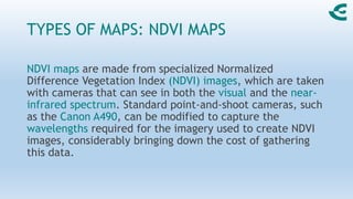
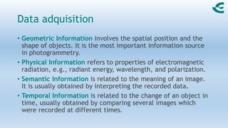
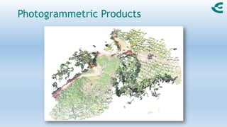
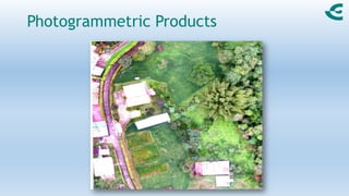
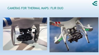
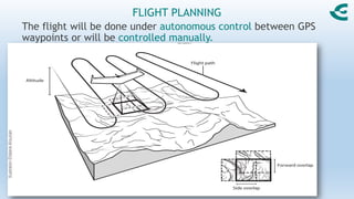
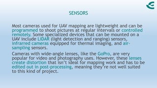
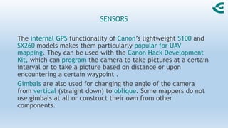
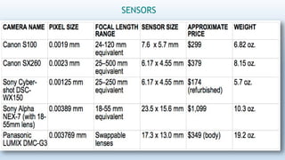
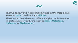
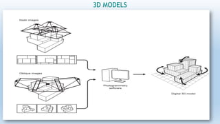
SlideShare a Scribd company logo
ArcGIS Course
Topic: Photogrammetry
Gómez, F.
August 2021
www.fgtraining.com.co
Definition
“Photogrammetry is the science of obtaining reliable information
about the properties of surfaces and objects without physical
contact with the objects, and of measuring and interpreting this
information”
is derived from the three Greek words:
phos or phot light
gramma letter or something drawn
metrein measure
HOW TO MAKE MAPS WITH DRONES
TYPES OF MAPS: ORTHOMOSAICS, 3D MODELS, OTHERS.
UAVs can produce a number of different types of maps:
orthorectified maps, elevation models, termal maps, and 3D
maps or models. The photogrammetry is used here.
The simplest way to create a mosaic from aerial imagery is by
using photo-stitching software, which combines a series of
overlapping aerial photographs into a single image.
An orthotmosaic is a series of overlapping aerial photographs
that have been geometrically corrected.
TYPES OF MAPS: ORTHOMOSAICS, 3D
MODELS, OTHERS.
3D models, which permit researchers to make volume
calculations from a set of aerial images, are increasingly
common outputs from UAV technology.
Other data products that can be made from UAV-collected
imagery include digital elevation models (DEM), NDVI
(vegetation) maps, and thermal maps, which require
specialized payloads and processing software.
TYPES OF MAPS: NDVI MAPS
NDVI maps are made from specialized Normalized
Difference Vegetation Index (NDVI) images, which are taken
with cameras that can see in both the visual and the near-
infrared spectrum. Standard point-and-shoot cameras, such
as the Canon A490, can be modified to capture the
wavelengths required for the imagery used to create NDVI
images, considerably bringing down the cost of gathering
this data.
Data adquisition
• Geometric Information involves the spatial position and the
shape of objects. It is the most important information source
in photogrammetry.
• Physical Information refers to properties of electromagnetic
radiation, e.g., radiant energy, wavelength, and polarization.
• Semantic Information is related to the meaning of an image.
It is usually obtained by interpreting the recorded data.
• Temporal Information is related to the change of an object in
time, usually obtained by comparing several images which
were recorded at different times.
Data adquisition
Photogrammetric Products
TYPES OF MAPS: THERMAL MAPS.
Thermal maps image the temperatures of a given mapping area,
and are useful for applications such as detecting structural
damage to roads, identifying the source of groundwater
discharge, spotting hidden archaeological ruins, and detecting
roe deer fawns. Specialized thermal imaging cameras, such as
those made by FLIR are light enough to be mounted on a UAV
and are increasingly being adopted by civilian pilots interested
in gathering thermal imagery.
CAMERAS FOR THERMAL MAPS: FLIR DUO
FLIGHT PLANNING
The flight will be done under autonomous control between GPS
waypoints or will be controlled manually.
IMAGE OVERLAP
FLIGHT PLANNING FOR IMAGE QUALITY
Resolution in aerial photography is measured as ground sampling
distance (GSD)—the length on the ground corresponding to the
side of one pixel in the image, or the distance between pixel
centers measured on the ground (these are equivalent). GSD is
also affected by the camera’s focal length, as well as its pixel
size. The larger pixel size means the sensor will be more
sensitive, allowing for a faster shutter speed in given light
conditions and better image quality generally.
Canon S100 lens, zoomed out, has a
focal length of 5.2 mm (26 mm zoomed
in). So if we wanted, say, to be able to
resolve 1 cm-sized features on the
ground using a zoomed-out S100, we
would have to fly at
1 cm x 5.2 mm / 0.0019 mm = 27.3 m =
89.7 feet
SENSORS
Most cameras used for UAV mapping are lightweight and can be
programmed to shoot pictures at regular intervals or controlled
remotely. Some specialized devices that can be mounted on a
UAV include LiDAR (light detection and ranging) sensors,
infrarred cameras equipped for thermal imaging, and air-
sampling sensors.
Cameras with wide-angle lenses, like the GoPro, are very
popular for video and photography uses. However, these lenses
create distortion that isn’t ideal for mapping work and has to be
edited out in post-processing, meaning they’re not well suited
to this kind of project.
SENSORS
The internal GPS functionality of Canon’s lightweight S100 and
SX260 models makes them particularly popular for UAV
mapping. They can be used with the Canon Hack Development
Kit, which can program the camera to take pictures at a certain
interval or to take a picture based on distance or upon
encountering a certain waypoint .
Gimbals are also used for changing the angle of the camera
from vertical (straight down) to oblique. Some mappers do not
use gimbals at all or construct their own from other
components.
SENSORS
VIEWS
The two aerial views most commonly used in UAV mapping are
known as nadir (overhead) and oblique.
Photos taken from these two different angles can be combined
in photogrammetry software (such as Agisoft Metashape,
UASMaster or Pix4Dmapper)
Software for UAS / Photogrammetry
Tomado de https://geoinnova.org/blog-territorio/comparativa-de-programas-para-fotogrametria/
Agisoft Metashape
UASMaster
Pix4Dmapper
Drone2Map for ArcGIS
Pix4D forums in Latin America
GPS AND GEOREFERENCING
Some digital cameras, such as the Canon S100, come with the
ability to track the GPS location of where each image was
captured, producing data that can then be used to georeference
the image with processing software.
Some UAVs use direct georeferencing techniques that do not
require the use of ground control points, including specialized
mapping UAVs such as the MAVinci SIRIUS Pro and the SenseFly
eBee RTK model. Real Time Kinematic (RTK) satellite navigation is
a positioning technique capable of producing survey-grade
accurate results down to the centimeter level by measuring the
phase of the radio wave sent by GPS satellites.
GROUND CONTROL POINTS
A ground control point, as previously mentioned, is a target in
the desired mapping area with known coordinates, which can be
used to find the coordinates of other locations on the map.
3D MODELS
3D PRINTERS
REFERENCIAS
• T. Schenk, 2005. Introduction to Photogrammetry. Department
of Civil and Environmental Engineering and Geodetic Science.
The Ohio State University.

More Related Content

Similar to PhotogrammetryArcGIS_V202108.pdf

Photogrammetry.pdf
Photogrammetry.pdfPhotogrammetry.pdf
Photogrammetry.pdf
BSuresh26
 
Photogrammetry: Latest Technology to Create Maps Using Drones?
Photogrammetry: Latest Technology to Create Maps Using Drones?Photogrammetry: Latest Technology to Create Maps Using Drones?
Photogrammetry: Latest Technology to Create Maps Using Drones?
NI BT
 
Surveying Innovations in Quarrying
Surveying Innovations in QuarryingSurveying Innovations in Quarrying
Surveying Innovations in Quarrying
Erik Birzulis
 
Photographic survey
Photographic survey Photographic survey
Photographic survey
PrajwalDeshmukh11
 
Aerial Photography.pptx
Aerial Photography.pptxAerial Photography.pptx
Aerial Photography.pptx
anjalisingh320458
 
Photogrammetry Surveying, its Benefits & Drawbacks
Photogrammetry Surveying, its Benefits & DrawbacksPhotogrammetry Surveying, its Benefits & Drawbacks
Photogrammetry Surveying, its Benefits & Drawbacks
NI BT
 
GPS & GIS
GPS & GISGPS & GIS
GPS & GIS
Onkar Gavel
 
Photogrammetry 101
Photogrammetry 101Photogrammetry 101
Laser-beams, spacecraft and archaeology; recent approaches to the recording, ...
Laser-beams, spacecraft and archaeology; recent approaches to the recording, ...Laser-beams, spacecraft and archaeology; recent approaches to the recording, ...
Laser-beams, spacecraft and archaeology; recent approaches to the recording, ...
Paul Cripps
 
DroneSurvey.pdf
DroneSurvey.pdfDroneSurvey.pdf
DroneSurvey.pdf
ParthPotdar4
 
The Truth About Drones in Mapping and Surveying
The Truth About Drones in Mapping and SurveyingThe Truth About Drones in Mapping and Surveying
The Truth About Drones in Mapping and Surveying
Peter Sydoruk, P.Eng.
 
Utilizing drone in land development
Utilizing drone  in land developmentUtilizing drone  in land development
Utilizing drone in land development
Kosygin Leishangthem
 
GST - First Class Intro, Unit 1 and Unit 2 Part.pptx
GST - First Class Intro, Unit 1 and Unit 2 Part.pptxGST - First Class Intro, Unit 1 and Unit 2 Part.pptx
GST - First Class Intro, Unit 1 and Unit 2 Part.pptx
poola2015
 
Remote Sensing Field Camp 2016
Remote Sensing Field Camp 2016 Remote Sensing Field Camp 2016
Remote Sensing Field Camp 2016
COGS Presentations
 
Business prezentaciya az-en
Business prezentaciya az-enBusiness prezentaciya az-en
Business prezentaciya az-enOleg Kupervasser
 
REMOTE SENSING_TOPIC_II_2023.pptx
REMOTE SENSING_TOPIC_II_2023.pptxREMOTE SENSING_TOPIC_II_2023.pptx
REMOTE SENSING_TOPIC_II_2023.pptx
armanisingh31
 
Unmanned Aerial Vehicle Application
Unmanned Aerial Vehicle ApplicationUnmanned Aerial Vehicle Application
Unmanned Aerial Vehicle Application
NopphawanTamkuan
 
Laser ScanningLaser scanning is an emerging data acquisition techn.pdf
Laser ScanningLaser scanning is an emerging data acquisition techn.pdfLaser ScanningLaser scanning is an emerging data acquisition techn.pdf
Laser ScanningLaser scanning is an emerging data acquisition techn.pdf
anjaniar7gallery
 
Accuracy checks in the production of orthophotos
Accuracy checks in the production of orthophotosAccuracy checks in the production of orthophotos
Accuracy checks in the production of orthophotos
Alexander Decker
 

Similar to PhotogrammetryArcGIS_V202108.pdf (20)

Photogrammetry.pdf
Photogrammetry.pdfPhotogrammetry.pdf
Photogrammetry.pdf
 
Photogrammetry: Latest Technology to Create Maps Using Drones?
Photogrammetry: Latest Technology to Create Maps Using Drones?Photogrammetry: Latest Technology to Create Maps Using Drones?
Photogrammetry: Latest Technology to Create Maps Using Drones?
 
Surveying Innovations in Quarrying
Surveying Innovations in QuarryingSurveying Innovations in Quarrying
Surveying Innovations in Quarrying
 
Photographic survey
Photographic survey Photographic survey
Photographic survey
 
Aerial Photography.pptx
Aerial Photography.pptxAerial Photography.pptx
Aerial Photography.pptx
 
Photogrammetry Surveying, its Benefits & Drawbacks
Photogrammetry Surveying, its Benefits & DrawbacksPhotogrammetry Surveying, its Benefits & Drawbacks
Photogrammetry Surveying, its Benefits & Drawbacks
 
GPS & GIS
GPS & GISGPS & GIS
GPS & GIS
 
Photogrammetry 101
Photogrammetry 101Photogrammetry 101
Photogrammetry 101
 
Laser-beams, spacecraft and archaeology; recent approaches to the recording, ...
Laser-beams, spacecraft and archaeology; recent approaches to the recording, ...Laser-beams, spacecraft and archaeology; recent approaches to the recording, ...
Laser-beams, spacecraft and archaeology; recent approaches to the recording, ...
 
DroneSurvey.pdf
DroneSurvey.pdfDroneSurvey.pdf
DroneSurvey.pdf
 
Photogrammetry
PhotogrammetryPhotogrammetry
Photogrammetry
 
The Truth About Drones in Mapping and Surveying
The Truth About Drones in Mapping and SurveyingThe Truth About Drones in Mapping and Surveying
The Truth About Drones in Mapping and Surveying
 
Utilizing drone in land development
Utilizing drone  in land developmentUtilizing drone  in land development
Utilizing drone in land development
 
GST - First Class Intro, Unit 1 and Unit 2 Part.pptx
GST - First Class Intro, Unit 1 and Unit 2 Part.pptxGST - First Class Intro, Unit 1 and Unit 2 Part.pptx
GST - First Class Intro, Unit 1 and Unit 2 Part.pptx
 
Remote Sensing Field Camp 2016
Remote Sensing Field Camp 2016 Remote Sensing Field Camp 2016
Remote Sensing Field Camp 2016
 
Business prezentaciya az-en
Business prezentaciya az-enBusiness prezentaciya az-en
Business prezentaciya az-en
 
REMOTE SENSING_TOPIC_II_2023.pptx
REMOTE SENSING_TOPIC_II_2023.pptxREMOTE SENSING_TOPIC_II_2023.pptx
REMOTE SENSING_TOPIC_II_2023.pptx
 
Unmanned Aerial Vehicle Application
Unmanned Aerial Vehicle ApplicationUnmanned Aerial Vehicle Application
Unmanned Aerial Vehicle Application
 
Laser ScanningLaser scanning is an emerging data acquisition techn.pdf
Laser ScanningLaser scanning is an emerging data acquisition techn.pdfLaser ScanningLaser scanning is an emerging data acquisition techn.pdf
Laser ScanningLaser scanning is an emerging data acquisition techn.pdf
 
Accuracy checks in the production of orthophotos
Accuracy checks in the production of orthophotosAccuracy checks in the production of orthophotos
Accuracy checks in the production of orthophotos
 

Recently uploaded

2137ad - Characters that live in Merindol and are at the center of main stories
2137ad - Characters that live in Merindol and are at the center of main stories2137ad - Characters that live in Merindol and are at the center of main stories
2137ad - Characters that live in Merindol and are at the center of main stories
luforfor
 
Memory Rental Store - The Ending(Storyboard)
Memory Rental Store - The Ending(Storyboard)Memory Rental Store - The Ending(Storyboard)
Memory Rental Store - The Ending(Storyboard)
SuryaKalyan3
 
Inter-Dimensional Girl Boards Segment (Act 3)
Inter-Dimensional Girl Boards Segment (Act 3)Inter-Dimensional Girl Boards Segment (Act 3)
Inter-Dimensional Girl Boards Segment (Act 3)
CristianMestre
 
一比一原版(GU毕业证)格里菲斯大学毕业证成绩单
一比一原版(GU毕业证)格里菲斯大学毕业证成绩单一比一原版(GU毕业证)格里菲斯大学毕业证成绩单
一比一原版(GU毕业证)格里菲斯大学毕业证成绩单
zvaywau
 
一比一原版(qut毕业证)昆士兰科技大学毕业证如何办理
一比一原版(qut毕业证)昆士兰科技大学毕业证如何办理一比一原版(qut毕业证)昆士兰科技大学毕业证如何办理
一比一原版(qut毕业证)昆士兰科技大学毕业证如何办理
taqyed
 
ashokathegreat project class 12 presentation
ashokathegreat project class 12 presentationashokathegreat project class 12 presentation
ashokathegreat project class 12 presentation
aditiyad2020
 
一比一原版(QUT毕业证)昆士兰科技大学毕业证成绩单如何办理
一比一原版(QUT毕业证)昆士兰科技大学毕业证成绩单如何办理一比一原版(QUT毕业证)昆士兰科技大学毕业证成绩单如何办理
一比一原版(QUT毕业证)昆士兰科技大学毕业证成绩单如何办理
zeyhe
 
2137ad Merindol Colony Interiors where refugee try to build a seemengly norm...
2137ad  Merindol Colony Interiors where refugee try to build a seemengly norm...2137ad  Merindol Colony Interiors where refugee try to build a seemengly norm...
2137ad Merindol Colony Interiors where refugee try to build a seemengly norm...
luforfor
 
一比一原版(DU毕业证)迪肯大学毕业证成绩单
一比一原版(DU毕业证)迪肯大学毕业证成绩单一比一原版(DU毕业证)迪肯大学毕业证成绩单
一比一原版(DU毕业证)迪肯大学毕业证成绩单
zvaywau
 
Codes n Conventionss copy (2).pptx new new
Codes n Conventionss copy (2).pptx new newCodes n Conventionss copy (2).pptx new new
Codes n Conventionss copy (2).pptx new new
ZackSpencer3
 
ART FORMS OF KERALA: TRADITIONAL AND OTHERS
ART FORMS OF KERALA: TRADITIONAL AND OTHERSART FORMS OF KERALA: TRADITIONAL AND OTHERS
ART FORMS OF KERALA: TRADITIONAL AND OTHERS
Sandhya J.Nair
 
IrishWritersCtrsPersonalEssaysMay29.pptx
IrishWritersCtrsPersonalEssaysMay29.pptxIrishWritersCtrsPersonalEssaysMay29.pptx
IrishWritersCtrsPersonalEssaysMay29.pptx
Aine Greaney Ellrott
 
A Brief Introduction About Hadj Ounis
A Brief  Introduction  About  Hadj OunisA Brief  Introduction  About  Hadj Ounis
A Brief Introduction About Hadj Ounis
Hadj Ounis
 
Caffeinated Pitch Bible- developed by Claire Wilson
Caffeinated Pitch Bible- developed by Claire WilsonCaffeinated Pitch Bible- developed by Claire Wilson
Caffeinated Pitch Bible- developed by Claire Wilson
ClaireWilson398082
 
The Last Polymath: Muntadher Saleh‎‎‎‎‎‎‎‎‎‎‎‎
The Last Polymath: Muntadher Saleh‎‎‎‎‎‎‎‎‎‎‎‎The Last Polymath: Muntadher Saleh‎‎‎‎‎‎‎‎‎‎‎‎
The Last Polymath: Muntadher Saleh‎‎‎‎‎‎‎‎‎‎‎‎
iraqartsandculture
 
一比一原版(UniSA毕业证)南澳大学毕业证成绩单如何办理
一比一原版(UniSA毕业证)南澳大学毕业证成绩单如何办理一比一原版(UniSA毕业证)南澳大学毕业证成绩单如何办理
一比一原版(UniSA毕业证)南澳大学毕业证成绩单如何办理
zeyhe
 
Fed by curiosity and beauty - Remembering Myrsine Zorba
Fed by curiosity and beauty - Remembering Myrsine ZorbaFed by curiosity and beauty - Remembering Myrsine Zorba
Fed by curiosity and beauty - Remembering Myrsine Zorba
mariavlachoupt
 
acting board rough title here lolaaaaaaa
acting board rough title here lolaaaaaaaacting board rough title here lolaaaaaaa
acting board rough title here lolaaaaaaa
angelicafronda7
 
Memory Rental Store - The Chase (Storyboard)
Memory Rental Store - The Chase (Storyboard)Memory Rental Store - The Chase (Storyboard)
Memory Rental Store - The Chase (Storyboard)
SuryaKalyan3
 

Recently uploaded (19)

2137ad - Characters that live in Merindol and are at the center of main stories
2137ad - Characters that live in Merindol and are at the center of main stories2137ad - Characters that live in Merindol and are at the center of main stories
2137ad - Characters that live in Merindol and are at the center of main stories
 
Memory Rental Store - The Ending(Storyboard)
Memory Rental Store - The Ending(Storyboard)Memory Rental Store - The Ending(Storyboard)
Memory Rental Store - The Ending(Storyboard)
 
Inter-Dimensional Girl Boards Segment (Act 3)
Inter-Dimensional Girl Boards Segment (Act 3)Inter-Dimensional Girl Boards Segment (Act 3)
Inter-Dimensional Girl Boards Segment (Act 3)
 
一比一原版(GU毕业证)格里菲斯大学毕业证成绩单
一比一原版(GU毕业证)格里菲斯大学毕业证成绩单一比一原版(GU毕业证)格里菲斯大学毕业证成绩单
一比一原版(GU毕业证)格里菲斯大学毕业证成绩单
 
一比一原版(qut毕业证)昆士兰科技大学毕业证如何办理
一比一原版(qut毕业证)昆士兰科技大学毕业证如何办理一比一原版(qut毕业证)昆士兰科技大学毕业证如何办理
一比一原版(qut毕业证)昆士兰科技大学毕业证如何办理
 
ashokathegreat project class 12 presentation
ashokathegreat project class 12 presentationashokathegreat project class 12 presentation
ashokathegreat project class 12 presentation
 
一比一原版(QUT毕业证)昆士兰科技大学毕业证成绩单如何办理
一比一原版(QUT毕业证)昆士兰科技大学毕业证成绩单如何办理一比一原版(QUT毕业证)昆士兰科技大学毕业证成绩单如何办理
一比一原版(QUT毕业证)昆士兰科技大学毕业证成绩单如何办理
 
2137ad Merindol Colony Interiors where refugee try to build a seemengly norm...
2137ad  Merindol Colony Interiors where refugee try to build a seemengly norm...2137ad  Merindol Colony Interiors where refugee try to build a seemengly norm...
2137ad Merindol Colony Interiors where refugee try to build a seemengly norm...
 
一比一原版(DU毕业证)迪肯大学毕业证成绩单
一比一原版(DU毕业证)迪肯大学毕业证成绩单一比一原版(DU毕业证)迪肯大学毕业证成绩单
一比一原版(DU毕业证)迪肯大学毕业证成绩单
 
Codes n Conventionss copy (2).pptx new new
Codes n Conventionss copy (2).pptx new newCodes n Conventionss copy (2).pptx new new
Codes n Conventionss copy (2).pptx new new
 
ART FORMS OF KERALA: TRADITIONAL AND OTHERS
ART FORMS OF KERALA: TRADITIONAL AND OTHERSART FORMS OF KERALA: TRADITIONAL AND OTHERS
ART FORMS OF KERALA: TRADITIONAL AND OTHERS
 
IrishWritersCtrsPersonalEssaysMay29.pptx
IrishWritersCtrsPersonalEssaysMay29.pptxIrishWritersCtrsPersonalEssaysMay29.pptx
IrishWritersCtrsPersonalEssaysMay29.pptx
 
A Brief Introduction About Hadj Ounis
A Brief  Introduction  About  Hadj OunisA Brief  Introduction  About  Hadj Ounis
A Brief Introduction About Hadj Ounis
 
Caffeinated Pitch Bible- developed by Claire Wilson
Caffeinated Pitch Bible- developed by Claire WilsonCaffeinated Pitch Bible- developed by Claire Wilson
Caffeinated Pitch Bible- developed by Claire Wilson
 
The Last Polymath: Muntadher Saleh‎‎‎‎‎‎‎‎‎‎‎‎
The Last Polymath: Muntadher Saleh‎‎‎‎‎‎‎‎‎‎‎‎The Last Polymath: Muntadher Saleh‎‎‎‎‎‎‎‎‎‎‎‎
The Last Polymath: Muntadher Saleh‎‎‎‎‎‎‎‎‎‎‎‎
 
一比一原版(UniSA毕业证)南澳大学毕业证成绩单如何办理
一比一原版(UniSA毕业证)南澳大学毕业证成绩单如何办理一比一原版(UniSA毕业证)南澳大学毕业证成绩单如何办理
一比一原版(UniSA毕业证)南澳大学毕业证成绩单如何办理
 
Fed by curiosity and beauty - Remembering Myrsine Zorba
Fed by curiosity and beauty - Remembering Myrsine ZorbaFed by curiosity and beauty - Remembering Myrsine Zorba
Fed by curiosity and beauty - Remembering Myrsine Zorba
 
acting board rough title here lolaaaaaaa
acting board rough title here lolaaaaaaaacting board rough title here lolaaaaaaa
acting board rough title here lolaaaaaaa
 
Memory Rental Store - The Chase (Storyboard)
Memory Rental Store - The Chase (Storyboard)Memory Rental Store - The Chase (Storyboard)
Memory Rental Store - The Chase (Storyboard)
 

PhotogrammetryArcGIS_V202108.pdf

  • 1. ArcGIS Course Topic: Photogrammetry Gómez, F. August 2021 www.fgtraining.com.co
  • 2. Definition “Photogrammetry is the science of obtaining reliable information about the properties of surfaces and objects without physical contact with the objects, and of measuring and interpreting this information” is derived from the three Greek words: phos or phot light gramma letter or something drawn metrein measure
  • 3. HOW TO MAKE MAPS WITH DRONES TYPES OF MAPS: ORTHOMOSAICS, 3D MODELS, OTHERS. UAVs can produce a number of different types of maps: orthorectified maps, elevation models, termal maps, and 3D maps or models. The photogrammetry is used here. The simplest way to create a mosaic from aerial imagery is by using photo-stitching software, which combines a series of overlapping aerial photographs into a single image. An orthotmosaic is a series of overlapping aerial photographs that have been geometrically corrected.
  • 4. TYPES OF MAPS: ORTHOMOSAICS, 3D MODELS, OTHERS. 3D models, which permit researchers to make volume calculations from a set of aerial images, are increasingly common outputs from UAV technology. Other data products that can be made from UAV-collected imagery include digital elevation models (DEM), NDVI (vegetation) maps, and thermal maps, which require specialized payloads and processing software.
  • 5.
  • 6. TYPES OF MAPS: NDVI MAPS NDVI maps are made from specialized Normalized Difference Vegetation Index (NDVI) images, which are taken with cameras that can see in both the visual and the near- infrared spectrum. Standard point-and-shoot cameras, such as the Canon A490, can be modified to capture the wavelengths required for the imagery used to create NDVI images, considerably bringing down the cost of gathering this data.
  • 7. Data adquisition • Geometric Information involves the spatial position and the shape of objects. It is the most important information source in photogrammetry. • Physical Information refers to properties of electromagnetic radiation, e.g., radiant energy, wavelength, and polarization. • Semantic Information is related to the meaning of an image. It is usually obtained by interpreting the recorded data. • Temporal Information is related to the change of an object in time, usually obtained by comparing several images which were recorded at different times.
  • 13. TYPES OF MAPS: THERMAL MAPS. Thermal maps image the temperatures of a given mapping area, and are useful for applications such as detecting structural damage to roads, identifying the source of groundwater discharge, spotting hidden archaeological ruins, and detecting roe deer fawns. Specialized thermal imaging cameras, such as those made by FLIR are light enough to be mounted on a UAV and are increasingly being adopted by civilian pilots interested in gathering thermal imagery.
  • 14. CAMERAS FOR THERMAL MAPS: FLIR DUO
  • 15. FLIGHT PLANNING The flight will be done under autonomous control between GPS waypoints or will be controlled manually.
  • 17. FLIGHT PLANNING FOR IMAGE QUALITY Resolution in aerial photography is measured as ground sampling distance (GSD)—the length on the ground corresponding to the side of one pixel in the image, or the distance between pixel centers measured on the ground (these are equivalent). GSD is also affected by the camera’s focal length, as well as its pixel size. The larger pixel size means the sensor will be more sensitive, allowing for a faster shutter speed in given light conditions and better image quality generally.
  • 18. Canon S100 lens, zoomed out, has a focal length of 5.2 mm (26 mm zoomed in). So if we wanted, say, to be able to resolve 1 cm-sized features on the ground using a zoomed-out S100, we would have to fly at 1 cm x 5.2 mm / 0.0019 mm = 27.3 m = 89.7 feet
  • 19. SENSORS Most cameras used for UAV mapping are lightweight and can be programmed to shoot pictures at regular intervals or controlled remotely. Some specialized devices that can be mounted on a UAV include LiDAR (light detection and ranging) sensors, infrarred cameras equipped for thermal imaging, and air- sampling sensors. Cameras with wide-angle lenses, like the GoPro, are very popular for video and photography uses. However, these lenses create distortion that isn’t ideal for mapping work and has to be edited out in post-processing, meaning they’re not well suited to this kind of project.
  • 20. SENSORS The internal GPS functionality of Canon’s lightweight S100 and SX260 models makes them particularly popular for UAV mapping. They can be used with the Canon Hack Development Kit, which can program the camera to take pictures at a certain interval or to take a picture based on distance or upon encountering a certain waypoint . Gimbals are also used for changing the angle of the camera from vertical (straight down) to oblique. Some mappers do not use gimbals at all or construct their own from other components.
  • 22. VIEWS The two aerial views most commonly used in UAV mapping are known as nadir (overhead) and oblique. Photos taken from these two different angles can be combined in photogrammetry software (such as Agisoft Metashape, UASMaster or Pix4Dmapper)
  • 23. Software for UAS / Photogrammetry Tomado de https://geoinnova.org/blog-territorio/comparativa-de-programas-para-fotogrametria/
  • 28. Pix4D forums in Latin America
  • 29. GPS AND GEOREFERENCING Some digital cameras, such as the Canon S100, come with the ability to track the GPS location of where each image was captured, producing data that can then be used to georeference the image with processing software. Some UAVs use direct georeferencing techniques that do not require the use of ground control points, including specialized mapping UAVs such as the MAVinci SIRIUS Pro and the SenseFly eBee RTK model. Real Time Kinematic (RTK) satellite navigation is a positioning technique capable of producing survey-grade accurate results down to the centimeter level by measuring the phase of the radio wave sent by GPS satellites.
  • 30. GROUND CONTROL POINTS A ground control point, as previously mentioned, is a target in the desired mapping area with known coordinates, which can be used to find the coordinates of other locations on the map.
  • 33. REFERENCIAS • T. Schenk, 2005. Introduction to Photogrammetry. Department of Civil and Environmental Engineering and Geodetic Science. The Ohio State University.