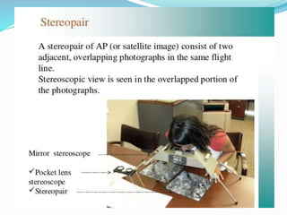
Photogrammetry
Photogrammetry can be defined as the science and art
of determining qualitative and quantitative characteristics of
objects from the images recorded on photographic emulsions.
Objects are identified and qualitatively described by
observing photographic image characteristics such as shape,
pattern, tone, and texture. Identification of deciduous versus
coniferous trees, delineation of geologic landforms, and
inventories of existing land use are examples of qualitative
observations obtained from photography.
 Photos – light
 Gramma – to draw
 Metron – to measure
I n t r o d u c t i o n
• Photogrammetric surveying or photogrammetry is the branch
of surveying in which maps are prepared from photo-graphs
taken from ground or air stations.
• With an advancement of the photogrammetric techniques,
photographs are also being used for the interpretation of
geology, classification of soils and crops, etc.
• Is the science of making measurements from photographs,
especially for recovering the exact positions of surface points.
• Used to recover the motion pathways of designated reference
points located on any moving object, on its components and in
the immediately adjacent environment.
• Photogrammetry may employ high-speed imaging and remote
sensing in order to detect, measure and record complex 2-D
and 3-D motion fields.
• Photogrammetry is the practice of determining
the geometric properties of objects from
photographic images.
• Is the making of precise measurements from
photographs; the making of maps from
photographs, especially from aerial surveying.
• The science of using aerial photography and
other remote sensing imagery to obtain
measurement of natural and man-made features
on the earth.
• In this method, object are measured without
being touched.
Broadly Photogrammetry Requires:
• Planing & taking the photographs
• Processing the photographs
• Measuring the photographs & Reducing the measurement to
produce end results.
Field Application of Photogrammetry :
• Used to conduct topographical survey or engineering surveys.
Suitable for mountainous and hilly terrain with little vegetation.
• Used for geological mapping which includes identification
of land forms, rock type & rock structures.
• Used for projects demanding higher accuracy, since it provides
accurate measurements.
• Used in urban and regional planning applications.
• Used mostly in Planning/designing in transport planning,
bridge, pipeline, hydropower, urban planning, security
and strategic planning, disaster management, natural
resources management, city models, conservation of
archaeological sites etc.
Used in different fields, such as topographic mapping, architecture, engineering,
manufacturing, quality control, police investigation, and geology, as well as by
archaeologists to quickly produce plans of large or complex sites and by
meteorologists.
Advantage
• Covers large area
• Less time consuming/fast
• Can ‘reach’ inaccessible and restricted area
• Cheap/cost effective for large area and in a long run
• Easy to interpret, understand
Disadvantage
• Complex system, highly trained human resource needed
• Costly at the time of installation/initiation
• Heavy and sophisticated equipments needed
• Lengthy administrative procedure for getting permission to fly
• Weather dependent
PRINCIPLE OF PHOTOGRAMMETRY
• Principle of photogrammetric survey in its simplest form
is very similar to that of the plane table survey.
• Only difference is that the most of the work which in
plane table survey is executed in the field, is done in
office.
• The principal point of each photograph is used as a fixed
station and rays are drawn to get points of intersections
very similar to those used in plane table.
• Is suitable for topographical or engineering surveys and
also for those projects demanding higher accuracy.
• It is unsuitable for dense forest and flat-sands due to
• the difficulty of identifying points upon the pair of
photographs.
Low
T YPES OF PHOTOGRAMMETRY /
PHOTOGRAPHS
The photographs used in photogrammetry may be broadly
classified into two types depending upon the camera position
at the time of photography.
The types are-
• Terrestrial Photographs
• Aerial Photographs
Terrestrial Photographs
• Photographs taken from camera station at a fixed position
on or near the ground is known as Terrestrial Photographs.
• The photographs are taken by means of a phototheodolite
which is combination of a camera and a theodolite.
• Based on the principle that “if the directions of same
objects photographed from two extremities of measured
base are known, their position can be located by the
intersection of two rays to the same object.
• Difference between this and plane tabling is that more details are at once
obtained from the photographs and their subsequent plotting etc. is done by
the office while in plane tabling all the detailing is done in the field itself.
• Fig A and B are the two stations at the ends of base AB.
• Arrows indicate the directions of horizontal pointing (in plan) of the camera.
• For each pair of pictures taken from the two ends, the camera axis is kept
parallel to each other.
• From economy and speed point of view, minimum number of photographs
should be used to cover the whole area and to achieve this, it is essential to
select the best positions of the camera stations.
• Study of the area should be done from the existing maps, and a ground
reconnaissance should be made. Selection of actual stations depends upon the
size and ruggedness of the area.
• These photographs provides the front view of elevation & are generally used
for the survey of structure & Architectural Monuments.
A E R I A L P H O T O G R A P H S
• Photographs taken from a Aerial camera mounted on a aerial vehicle
• Used for various purpose, mainly information extraction on the ground
surface
• Aerial photographs are obtained from the aerial cameras mounted on
aerial vehicle(aeroplane for the purpose of photography)
• Used for various purpose, mainly information extraction on the ground
surface
• Photographs are taken from camera station in the air with the axis of
camera vertical or nearly vertical.
• Is the branch of photogrammetry where the photographs are taken from
air station.
• This is the best mapping procedure yet developed for large objects and
are useful for military intelligence.
• For this, aerial camera is used which are fixed on flying aircraft.
According to the direction of the camera axis at the time of
exposure aerial photographs may be classified into:
• Vertical photographs
• Oblique photographs
Vertical photographs
• These photographs are taken from the air with the axis of
the Camera vertical or nearly vertical .
• A truly vertical Photograph closely resembles a map.
• These are utilized for the compilation of topographic and
engineering surveys on various scales.
O B L I Q U E P H O T O G R A P H S
Photographs are taken from air with the axis of the camera intentionally
tilted from the vertical. An oblique photograph covers larger area of the
ground but clarity of details diminishes towards the far end of the
photograph.
Depending upon the angle of obliquity, oblique photographs may he
further divided into two categories.
Low oblique photographs :
An oblique photograph which does not show the horizon, is known as low
oblique photograph. Such photographs are generally used to compile
reconnaissance maps of inaccessible areas.
High oblique photograph:
An oblique photograph which is sufficiently tilted to show the horizon, is
known as high oblique, photograph.
Such photographs were previously used for the extension of planimetric
and height control in areas having scanty ground control.
L o w o b l i q u e p h o t o g r a p h s
H i g h o b l i q u e p h o t o g r a p h s
THE PHOTO-THEODOLITE
CONSTRUCTION AND USE OF
PHOTOTHEODOLITE
• Is a combination of camera and
theodolite mounted on the same tripod,
• Used in terrestrial photogrammetry for
mapmaking and other purposes.
• Photographs obtained are used for the
construction of topographic maps,
classification of soil, interpretation of
geology.
• While taking the photographs the
camera axis is kept parallel to each
other.
It consists of :
• A camera box of fixed focus type
• A hollow rectangular frame placed
vertically to the rear side
• The sensified photographic plate.
• Camera box is supported on the tripod
and is furnished with an inner and
outer axis each of which is fitted with a
clamp and fine adjusting screw.
• The graduated horizontal circle carries
verniers reading to single minutes.
These are supported on a levelling head
carrying three foot screws.
• On the top of the box, a telescope is
fitted.
• The telescope can be rotated in a
vertical plane about a horizontal axis
and is fitted with vertical arc with
verniers, clamp & slow motion screw.
• The line of sight of the telescope is set
in the same vertical plane as the optical
axis of
• camera.
A e r i a l C a m e r a
• Aerial camera are used to have aerial
photographs which are fixed on flying
air carft.
• Primary function of the terrestrial
camera as well as the aerial camera is
the same, i.e., that of taking pictures.
Aerial camera is mounted on a fast
moving aeroplane, its requirements
are quite different.
Aerial camera requires :
• Fast Lens
• High speed & sufficient shutter
• High speed emulsion for the film
• A Magazine to hold large rolls of film
• Aerial camera is considered to be a
surveying instrument of great
precision.
• An aerial camera consists of following
essential parts
• lens assembly consists of lenses, the
diaphragm, shutter and the filter. (Fig-
6,8,9)
• Camera cone which supports the entire
lens assembly including the filter. (fig - 5)
• focal (2) plane exactly above the
collimation mark.
• camera body (3) provided at the top of
cone which acts as an integral part to
preserve the interior orientation.
• Drive mechanism which is housed in
camera body & used for winding and
tripping the shutter, operating the
vaccum system for flattering the film,
winding the film.
• The magazine (1) which holds the
exposed and unexposed films & houses
the film flattening device at the focal
plane.
There are three types of Aerial Camera :
• Super wide angle camera – f=100mm
(used in flat areas like terai of nepal & in plain areas)
• Wide angle camera – f=150mm
(Used in hilly areas)
• Narrow angle camera – f=300mm
(Used in higher himalayas, sky scrappers & city like New york)
BASIC TERMS USED IN PHOTOGRAMMETRY
• Exposure (or air) station (O): It is a point in space, in the
air, occupied by camera lens at the instant of exposour. The
exact position of the front nodal point of the lens in the air
at the instant of exposure.
• Flying height (H): The elevation of the air station above
the mean sea level is known as flying height of the aircraft.
• Focal length : it is the distance from the front nodal point
of the lens to the plane of photograph.
• Nadir Point (Plumb Point): The point where a plumb line
dropped from the front nodal point strikes the photograph.
• Ground Nadir point: it is the datum intersection with
plumb line through the front nodal point.
• Camera Axis : It is the line passing through the centre of
the camera lens perpendicular both to the camera plate
(negative) and the picture plane (photography).
• Fiducial mark –(Reference mark) A fiducial mark is one
of two, three or four marks, located in contact with the
photographic emulsion in a camera image plane to
provide a reference line or lines for the plate
measurement of images.
• Iso centre : The point in which the bisector of the angle
of tilt meets the photographs is known as Isocentre. It
lies on the principal line at a distance of f tan t/2 from the
principal point.
• Principal Point: The point where a perpendicular dropped
from the front nodal point strikes the photographs is
known as principal point of photograph
• Focal length – It is the perpendicular distance from the
centre of the camera lens to either the picture plane or
the camera plate.
• Tilt : The deviation of a plate from the horizontal plane at the time of
exposure is known as tilt.
• Horizontal Point (h): The point of intersection of the principal line (VIP)
and the horizontal line (oh) through the perspective centre O is known
as horizontal point.
• Swing: Is the angle measured in the plane of photograph from the
positive y-axis clockwise to the nadir point.
• Axis of tilt: Axis of tilt is a line in the plane of photograph and is
perpendicular to the principal line at the iso centre
Relief displacement.
Relief displacement is another
characteristic of the perspective
geometry recorded by an aerial
photograph. The displacement of an
image point caused by changes in
ground elevation is closely related to
photographic scale variation. Relief
displacement is evaluated when
analyzing or planning mosaic or
orthophoto projects. Relief
displacement is also a tool that can be
used in photo interpretation to
determine heights of vertical objects.
Procedure for Aerial survey ( Flight planning)
 Parameters
 Altitude of flight (H)
 Focal length of camera (f)
 Size of photograph
 Size of area or land to be photographed
 Alignment of flight line and parallel flight line
 Lateral overlap
 No of photo in each flight line and overlap
 Scale of flight map.
 Ground speed of aeroplane
 Time interval of successive photographs
Overlaps
Overlaps
Overlaps
 Longitudinal Overlap
 Overlap between two
photo 50% to 70%
 Overlap between two
alternate photo 10% to
20%
 Lateral Overlap
 Overlap between adjacent
flight lines
 Side overlap should be
20% to 30%.
Reasons for Overlaps
 Arrangement of mosaic
 Remove errors due to distortion, displacement, and tilt.
 For view in stereoscope- 3D view.
 Avoid repetition of aerial survey
CRAB AND DRIFT
Stereoscopic Vision
Angle of Parallax (Parallactic angle)
Stereoscopic Fusion
Lens stereoscope.
A lens or pocket stereoscope is a low-cost instrument that is very useful
in the field as well as the office. It offers a fixed magnification, typically 2.5X.
The lens stereoscope is useful for photo interpretation, control point design, and
verification of mapped planimetric and topographic features.
Mirror stereoscope.
A mirror stereoscope can be used for the same functions as a lens, but
is not appropriate for field use. The mirror stereoscope has a wider field of view
at the nominal magnification ratio. Since photographs can be held fixed for
stereo viewing under a mirror stereoscope, the instrument is useful for simple
stereoscopic measurements. Mirror stereoscopes can be equipped with
binocular eyepieces that yield 6X and 9X magnification. The high
magnification helps to identify, interpret, and measure photographed features.
PHOTOGRAMMETIC SURVEYING

PHOTOGRAMMETIC SURVEYING

  • 4.
    Photogrammetry Photogrammetry can bedefined as the science and art of determining qualitative and quantitative characteristics of objects from the images recorded on photographic emulsions. Objects are identified and qualitatively described by observing photographic image characteristics such as shape, pattern, tone, and texture. Identification of deciduous versus coniferous trees, delineation of geologic landforms, and inventories of existing land use are examples of qualitative observations obtained from photography.  Photos – light  Gramma – to draw  Metron – to measure
  • 5.
    I n tr o d u c t i o n • Photogrammetric surveying or photogrammetry is the branch of surveying in which maps are prepared from photo-graphs taken from ground or air stations. • With an advancement of the photogrammetric techniques, photographs are also being used for the interpretation of geology, classification of soils and crops, etc. • Is the science of making measurements from photographs, especially for recovering the exact positions of surface points. • Used to recover the motion pathways of designated reference points located on any moving object, on its components and in the immediately adjacent environment. • Photogrammetry may employ high-speed imaging and remote sensing in order to detect, measure and record complex 2-D and 3-D motion fields.
  • 6.
    • Photogrammetry isthe practice of determining the geometric properties of objects from photographic images. • Is the making of precise measurements from photographs; the making of maps from photographs, especially from aerial surveying. • The science of using aerial photography and other remote sensing imagery to obtain measurement of natural and man-made features on the earth. • In this method, object are measured without being touched.
  • 7.
    Broadly Photogrammetry Requires: •Planing & taking the photographs • Processing the photographs • Measuring the photographs & Reducing the measurement to produce end results. Field Application of Photogrammetry : • Used to conduct topographical survey or engineering surveys. Suitable for mountainous and hilly terrain with little vegetation. • Used for geological mapping which includes identification of land forms, rock type & rock structures. • Used for projects demanding higher accuracy, since it provides accurate measurements. • Used in urban and regional planning applications. • Used mostly in Planning/designing in transport planning, bridge, pipeline, hydropower, urban planning, security and strategic planning, disaster management, natural resources management, city models, conservation of archaeological sites etc.
  • 10.
    Used in differentfields, such as topographic mapping, architecture, engineering, manufacturing, quality control, police investigation, and geology, as well as by archaeologists to quickly produce plans of large or complex sites and by meteorologists. Advantage • Covers large area • Less time consuming/fast • Can ‘reach’ inaccessible and restricted area • Cheap/cost effective for large area and in a long run • Easy to interpret, understand Disadvantage • Complex system, highly trained human resource needed • Costly at the time of installation/initiation • Heavy and sophisticated equipments needed • Lengthy administrative procedure for getting permission to fly • Weather dependent
  • 11.
    PRINCIPLE OF PHOTOGRAMMETRY •Principle of photogrammetric survey in its simplest form is very similar to that of the plane table survey. • Only difference is that the most of the work which in plane table survey is executed in the field, is done in office. • The principal point of each photograph is used as a fixed station and rays are drawn to get points of intersections very similar to those used in plane table. • Is suitable for topographical or engineering surveys and also for those projects demanding higher accuracy. • It is unsuitable for dense forest and flat-sands due to • the difficulty of identifying points upon the pair of photographs.
  • 12.
    Low T YPES OFPHOTOGRAMMETRY / PHOTOGRAPHS
  • 13.
    The photographs usedin photogrammetry may be broadly classified into two types depending upon the camera position at the time of photography. The types are- • Terrestrial Photographs • Aerial Photographs Terrestrial Photographs • Photographs taken from camera station at a fixed position on or near the ground is known as Terrestrial Photographs. • The photographs are taken by means of a phototheodolite which is combination of a camera and a theodolite. • Based on the principle that “if the directions of same objects photographed from two extremities of measured base are known, their position can be located by the intersection of two rays to the same object.
  • 15.
    • Difference betweenthis and plane tabling is that more details are at once obtained from the photographs and their subsequent plotting etc. is done by the office while in plane tabling all the detailing is done in the field itself. • Fig A and B are the two stations at the ends of base AB. • Arrows indicate the directions of horizontal pointing (in plan) of the camera. • For each pair of pictures taken from the two ends, the camera axis is kept parallel to each other. • From economy and speed point of view, minimum number of photographs should be used to cover the whole area and to achieve this, it is essential to select the best positions of the camera stations. • Study of the area should be done from the existing maps, and a ground reconnaissance should be made. Selection of actual stations depends upon the size and ruggedness of the area. • These photographs provides the front view of elevation & are generally used for the survey of structure & Architectural Monuments.
  • 16.
    A E RI A L P H O T O G R A P H S • Photographs taken from a Aerial camera mounted on a aerial vehicle • Used for various purpose, mainly information extraction on the ground surface • Aerial photographs are obtained from the aerial cameras mounted on aerial vehicle(aeroplane for the purpose of photography) • Used for various purpose, mainly information extraction on the ground surface • Photographs are taken from camera station in the air with the axis of camera vertical or nearly vertical. • Is the branch of photogrammetry where the photographs are taken from air station. • This is the best mapping procedure yet developed for large objects and are useful for military intelligence. • For this, aerial camera is used which are fixed on flying aircraft.
  • 18.
    According to thedirection of the camera axis at the time of exposure aerial photographs may be classified into: • Vertical photographs • Oblique photographs Vertical photographs • These photographs are taken from the air with the axis of the Camera vertical or nearly vertical . • A truly vertical Photograph closely resembles a map. • These are utilized for the compilation of topographic and engineering surveys on various scales.
  • 20.
    O B LI Q U E P H O T O G R A P H S Photographs are taken from air with the axis of the camera intentionally tilted from the vertical. An oblique photograph covers larger area of the ground but clarity of details diminishes towards the far end of the photograph. Depending upon the angle of obliquity, oblique photographs may he further divided into two categories. Low oblique photographs : An oblique photograph which does not show the horizon, is known as low oblique photograph. Such photographs are generally used to compile reconnaissance maps of inaccessible areas. High oblique photograph: An oblique photograph which is sufficiently tilted to show the horizon, is known as high oblique, photograph. Such photographs were previously used for the extension of planimetric and height control in areas having scanty ground control.
  • 22.
    L o wo b l i q u e p h o t o g r a p h s
  • 23.
    H i gh o b l i q u e p h o t o g r a p h s
  • 24.
    THE PHOTO-THEODOLITE CONSTRUCTION ANDUSE OF PHOTOTHEODOLITE • Is a combination of camera and theodolite mounted on the same tripod, • Used in terrestrial photogrammetry for mapmaking and other purposes. • Photographs obtained are used for the construction of topographic maps, classification of soil, interpretation of geology. • While taking the photographs the camera axis is kept parallel to each other. It consists of : • A camera box of fixed focus type • A hollow rectangular frame placed vertically to the rear side • The sensified photographic plate.
  • 25.
    • Camera boxis supported on the tripod and is furnished with an inner and outer axis each of which is fitted with a clamp and fine adjusting screw. • The graduated horizontal circle carries verniers reading to single minutes. These are supported on a levelling head carrying three foot screws. • On the top of the box, a telescope is fitted. • The telescope can be rotated in a vertical plane about a horizontal axis and is fitted with vertical arc with verniers, clamp & slow motion screw. • The line of sight of the telescope is set in the same vertical plane as the optical axis of • camera.
  • 26.
    A e ri a l C a m e r a • Aerial camera are used to have aerial photographs which are fixed on flying air carft. • Primary function of the terrestrial camera as well as the aerial camera is the same, i.e., that of taking pictures. Aerial camera is mounted on a fast moving aeroplane, its requirements are quite different. Aerial camera requires : • Fast Lens • High speed & sufficient shutter • High speed emulsion for the film • A Magazine to hold large rolls of film • Aerial camera is considered to be a surveying instrument of great precision.
  • 28.
    • An aerialcamera consists of following essential parts • lens assembly consists of lenses, the diaphragm, shutter and the filter. (Fig- 6,8,9) • Camera cone which supports the entire lens assembly including the filter. (fig - 5) • focal (2) plane exactly above the collimation mark. • camera body (3) provided at the top of cone which acts as an integral part to preserve the interior orientation. • Drive mechanism which is housed in camera body & used for winding and tripping the shutter, operating the vaccum system for flattering the film, winding the film. • The magazine (1) which holds the exposed and unexposed films & houses the film flattening device at the focal plane.
  • 29.
    There are threetypes of Aerial Camera : • Super wide angle camera – f=100mm (used in flat areas like terai of nepal & in plain areas) • Wide angle camera – f=150mm (Used in hilly areas) • Narrow angle camera – f=300mm (Used in higher himalayas, sky scrappers & city like New york)
  • 30.
    BASIC TERMS USEDIN PHOTOGRAMMETRY • Exposure (or air) station (O): It is a point in space, in the air, occupied by camera lens at the instant of exposour. The exact position of the front nodal point of the lens in the air at the instant of exposure. • Flying height (H): The elevation of the air station above the mean sea level is known as flying height of the aircraft. • Focal length : it is the distance from the front nodal point of the lens to the plane of photograph. • Nadir Point (Plumb Point): The point where a plumb line dropped from the front nodal point strikes the photograph. • Ground Nadir point: it is the datum intersection with plumb line through the front nodal point. • Camera Axis : It is the line passing through the centre of the camera lens perpendicular both to the camera plate (negative) and the picture plane (photography).
  • 31.
    • Fiducial mark–(Reference mark) A fiducial mark is one of two, three or four marks, located in contact with the photographic emulsion in a camera image plane to provide a reference line or lines for the plate measurement of images. • Iso centre : The point in which the bisector of the angle of tilt meets the photographs is known as Isocentre. It lies on the principal line at a distance of f tan t/2 from the principal point. • Principal Point: The point where a perpendicular dropped from the front nodal point strikes the photographs is known as principal point of photograph • Focal length – It is the perpendicular distance from the centre of the camera lens to either the picture plane or the camera plate.
  • 32.
    • Tilt :The deviation of a plate from the horizontal plane at the time of exposure is known as tilt. • Horizontal Point (h): The point of intersection of the principal line (VIP) and the horizontal line (oh) through the perspective centre O is known as horizontal point. • Swing: Is the angle measured in the plane of photograph from the positive y-axis clockwise to the nadir point. • Axis of tilt: Axis of tilt is a line in the plane of photograph and is perpendicular to the principal line at the iso centre
  • 42.
    Relief displacement. Relief displacementis another characteristic of the perspective geometry recorded by an aerial photograph. The displacement of an image point caused by changes in ground elevation is closely related to photographic scale variation. Relief displacement is evaluated when analyzing or planning mosaic or orthophoto projects. Relief displacement is also a tool that can be used in photo interpretation to determine heights of vertical objects.
  • 53.
    Procedure for Aerialsurvey ( Flight planning)  Parameters  Altitude of flight (H)  Focal length of camera (f)  Size of photograph  Size of area or land to be photographed  Alignment of flight line and parallel flight line  Lateral overlap  No of photo in each flight line and overlap  Scale of flight map.  Ground speed of aeroplane  Time interval of successive photographs
  • 54.
  • 55.
  • 56.
    Overlaps  Longitudinal Overlap Overlap between two photo 50% to 70%  Overlap between two alternate photo 10% to 20%  Lateral Overlap  Overlap between adjacent flight lines  Side overlap should be 20% to 30%.
  • 57.
    Reasons for Overlaps Arrangement of mosaic  Remove errors due to distortion, displacement, and tilt.  For view in stereoscope- 3D view.  Avoid repetition of aerial survey
  • 63.
  • 70.
  • 71.
    Angle of Parallax(Parallactic angle) Stereoscopic Fusion
  • 72.
    Lens stereoscope. A lensor pocket stereoscope is a low-cost instrument that is very useful in the field as well as the office. It offers a fixed magnification, typically 2.5X. The lens stereoscope is useful for photo interpretation, control point design, and verification of mapped planimetric and topographic features.
  • 73.
    Mirror stereoscope. A mirrorstereoscope can be used for the same functions as a lens, but is not appropriate for field use. The mirror stereoscope has a wider field of view at the nominal magnification ratio. Since photographs can be held fixed for stereo viewing under a mirror stereoscope, the instrument is useful for simple stereoscopic measurements. Mirror stereoscopes can be equipped with binocular eyepieces that yield 6X and 9X magnification. The high magnification helps to identify, interpret, and measure photographed features.