1. Lines of latitude and longitude combine to form a grid that maps locations globally.
2. Latitude lines run east-west and are horizontal, while longitude lines run north-south and are vertical.
3. The equator is 0 degrees latitude, while the prime meridian is 0 degrees longitude.
Lines of Latitude and Longitude – PowerPointYaryalitsa
PowerPoint on Lines of Latitude, Lines of Longitude, Climate Zones, Equinoxes, Solstices, The Three Norths, Prime Meridian, International Date Line, Greenwich Mean Time, Coordinated Universal Time.
Lines of Latitude and Longitude – Worksheet at:
http://www.slideshare.net/yaryalitsa/lines-of-latitude-and-longitude-worksheet
This is slide show created based on a tutorial hosted by Geography World and created by Mr. Bowerman. All credit for images and information go to them. I created this for use in a 4/5 grade gifted social studies and math lesson.
A coordinate system is a reference system used to represent the locations of geographic features, imagery, and observations, within a common geographic framework.
Coordinate systems enable geographic datasets to use common locations for integration.
This Presentation is to made concepts about measuring the earth (to locate position of any person on the whole earth). For this purpose we re going step by step basis in this presentation.These steps are mentioned as contents. After that you may able to learn about measuring a person's position of earth. Thank you!
learningfromgeography.wikispaces.com
learningfromhistory.wikispaces.com
Developed by Maria Jesús Campos, Social Studies, Geography and History teacher in a bilingual section in Madrid (Spain)
The Solar System is composed of the Sun and the celestial objects which are gravitationally bound to it: planets, moons, dwarf planets and their four known moons, asteroids, meteoroids, comets, and interplanetary dust.
Latitudes and longitudes and india size and locationRajesh Kumar
This presentation covers the following topics:
1. Geographic coordinate system, i.e, latitude and longitudes
2. Size and location of India
(because before understanding the size and location our country, Geographic coordinate system, i.e, latitude and longitudes are important)
which enables the students to locate all four hemispheres including
Northern Hemisphere
Southern Hemisphere
Eastern Hemisphere
Western Hemisphere
Students will be able to identify which line divides the earth into the correct hemispheres.
Students will be able to find locations on map using longitude and latitude.
We all have good and bad thoughts from time to time and situation to situation. We are bombarded daily with spiraling thoughts(both negative and positive) creating all-consuming feel , making us difficult to manage with associated suffering. Good thoughts are like our Mob Signal (Positive thought) amidst noise(negative thought) in the atmosphere. Negative thoughts like noise outweigh positive thoughts. These thoughts often create unwanted confusion, trouble, stress and frustration in our mind as well as chaos in our physical world. Negative thoughts are also known as “distorted thinking”.
Palestine last event orientationfvgnh .pptxRaedMohamed3
An EFL lesson about the current events in Palestine. It is intended to be for intermediate students who wish to increase their listening skills through a short lesson in power point.
How to Make a Field invisible in Odoo 17Celine George
It is possible to hide or invisible some fields in odoo. Commonly using “invisible” attribute in the field definition to invisible the fields. This slide will show how to make a field invisible in odoo 17.
Operation “Blue Star” is the only event in the history of Independent India where the state went into war with its own people. Even after about 40 years it is not clear if it was culmination of states anger over people of the region, a political game of power or start of dictatorial chapter in the democratic setup.
The people of Punjab felt alienated from main stream due to denial of their just demands during a long democratic struggle since independence. As it happen all over the word, it led to militant struggle with great loss of lives of military, police and civilian personnel. Killing of Indira Gandhi and massacre of innocent Sikhs in Delhi and other India cities was also associated with this movement.
How to Split Bills in the Odoo 17 POS ModuleCeline George
Bills have a main role in point of sale procedure. It will help to track sales, handling payments and giving receipts to customers. Bill splitting also has an important role in POS. For example, If some friends come together for dinner and if they want to divide the bill then it is possible by POS bill splitting. This slide will show how to split bills in odoo 17 POS.
This is a presentation by Dada Robert in a Your Skill Boost masterclass organised by the Excellence Foundation for South Sudan (EFSS) on Saturday, the 25th and Sunday, the 26th of May 2024.
He discussed the concept of quality improvement, emphasizing its applicability to various aspects of life, including personal, project, and program improvements. He defined quality as doing the right thing at the right time in the right way to achieve the best possible results and discussed the concept of the "gap" between what we know and what we do, and how this gap represents the areas we need to improve. He explained the scientific approach to quality improvement, which involves systematic performance analysis, testing and learning, and implementing change ideas. He also highlighted the importance of client focus and a team approach to quality improvement.
The Art Pastor's Guide to Sabbath | Steve ThomasonSteve Thomason
What is the purpose of the Sabbath Law in the Torah. It is interesting to compare how the context of the law shifts from Exodus to Deuteronomy. Who gets to rest, and why?
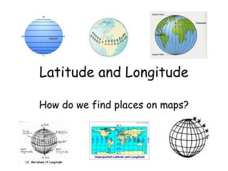
2. Latitude
What is Latitude?
• Lines of Latitude run horizontally
• Latitude is measured in degrees.
• The Equator is 0 degrees Latitude.
• Lines of Latitude locate places North or
South of the Equator.
• The North Pole is 90 degrees N Latitude, and
the South Pole is 90 degrees S Latitude.
3. Longitude
• Lines of Longitude run vertically.
• They are also called Meridians.
• The Prime Meridian is found in Greenwich,
England.
• The Prime Meridian is 0 degrees Longitude.
• Lines of Longitude locate places East or
West of the Prime Meridian.
• There are 180 degrees of east Longitude,
and 180 degrees of west Longitude.
4. Time Zones
• Time zones are broad strips that measure
15 degrees wide.
• Time zones differ from their neighboring
time zones by 1 hour.
• The continental U.S. has 4 time zones,
Eastern, Central, Mountain, and Pacific.
• In the Spring we shift the clocks 1 hour
ahead. This is called Daylight Saving Time.
• In the Fall we shift the clocks 1 hour back.
5. Time Zones (cont…)
Local Time and Universal Time
Local Time- is what we use everyday, and
regulates our lives.
Examples of Local Time are: meal time, sleep
time, work time, and school time
Universal Time- is what we use when we
need a time that is agreed upon marking
time world-wide.
An example when Universal Time was used
was when a supernova in 1987 was first
seen. Astronomers, and Astronauts use
Universal Time..
6. Time Zones (cont….)
• Greenwich Mean Time- is the time
that is registered at Greenwich,
England.
**Greenwich Mean Time is another
name for Universal Time.
The International Dateline was
established following the 180th
meridian, where ever we cross it
the date advances 1 day ( if you
are going west), or goes back 1 day
(if you are going east).
7. Summary
1.What do lines of Latitude and Longitude combine to
make?
A grid.
2.Compare and Contrast Latitude and Longitude.
Latitude- horizontal, north- south, parallels
Longitude- vertical, east-west, meridians
3.What is 0 degrees Latitude?
Equator
4.What is 0 degrees Longitude?
Prime Meridian
5.How many time zones do we have in the U.S.A.?
4- Eastern, Central, Mountain, Pacific
6. Explain the difference between Local Time, and Universal
Time.
Local time- used everyday
Universal Time- is used for a planetary event, or for
10. Learner Expectation
• Content Standard: 3.0 Geography
– 3.01 Understand how to use maps,
globes, and other geographic
representations, tools, and
technologies to acquire, process and
report information from a spatial
perspective.
11. In this activity you will:
• Learn about the elements of a map:
latitude, longitude, the hemispheres,
directions, time zone, scale, and map
legends.
• Write a paragraph describing the parts
of a map. Tell the function of each
part in reading a map.
13. Lines
• Longitude lines run north and south.
• Latitude lines run east and west.
• The lines measure distances in degrees.
Latitude
Longitude
14. Where is 0 degree?
• The equator is 0 degree latitude.
• It is an imaginary belt that runs
halfway point between the North Pole
and the South Pole.
Equator
15. P M
E
R
R
Where is 0 degree?
I I
D
M
I
• The prime meridian E 0Adegrees longitude.
is
This imaginary line runsNthrough the
United Kingdom, France, Spain, western
Africa, and Antarctica.
16.
17. Latitude and Longitude Resources
• Latitude & Longitude Activity
• A Printable Latitude & Longitude Map
• Latitude & Longitude Map Making
• Latitude and Longitude Quiz
18. Hemispheres
• By using the equator and prime
meridian, we can divide the
world into four hemispheres,
north, south, east, and west.
19.
20. Compass
• A compass is a tool that helps the
user know what direction one is
headed.
• On a map, a compass or a compass
rose helps the user locate these
directions.
21. Compass Rose
• The needle on a compass is magnetized to
point to the earth's north magnetic pole.
Thus with a compass, a person can roughly
tell which direction they are headed.
• There are four major or cardinal directions
on a compass- north, south, east & west. In
between are the directions northeast,
northwest, southeast, southwest.
• Direction Quiz
Source: http://aerocompass.larc.nasa
22. Directions
• The cardinal directions are north, south,
east, and west.
• The intermediate directions are northeast,
southeast, southwest and northwest.
• They help describe the location of places in
relation to other places.
23. Scale
• Maps are made to scale; that is, there is a
direct connection between a unit of
measurement on the map and the actual
distance.
• For example, each inch on the map
represents one mile on Earth. So, a map of
a town would show a mile-long strip of fast
food joints and auto dealers in one inch.
25. Time Zones
• The Earth is divided into 24 time
zones, corresponding to 24 hours in a
day.
• As the earth rotates, the sun shines in
different areas, moving from east to
west during the course of a day.
• Places that have the same longitude
will be in the same time zone.
26.
27. Map Legends
• The legend is the key to unlocking the secrets of
a map. Objects or colors in the legend represent
something on the map.
Religions Legend
30. Legend Reading Activities
• What You Can Learn From A Map
– What do Maps Show Activity
– Road Map
– Road Map Legend
– Road Map of Salt Lake City Region
– Map Worksheet
31. Sites to visit
• Look up Latitude and Longitude for US Cities
• Maps and Map Skills Degrees, Latitude, & Longitude
Worksheet
• Latitude and Longitude Map (lesson plan)
• Scale
• Time Zones
• Anchors Aweigh (a map adventure)
• Map Quiz
• Make Your Own Map
• Topography Maps
• U. S. Map Collection
• GeoSpy Game
• Globe Projector
32. Additional Sources
• Atlas - World (Holt, Rinehart and
Winston)
• Outline Map of US
• Map Packet Download
• Maps.com
• National Geographic Xpeditions
• Maps & Globes
34. Writing Activities
• Write a paragraph describing the
parts of a map. Tell the function of
each part in reading a map.
35.
36. Typical Graphexample of a
• This is an
typical graph we are
all familiar with.
• The graph is made up
of different “points”
with lines that connect
the points.
37. • Each point has two
Typical values:
Graph
• The “X” value that
Y axis
runs along the
horizontal “X”
axis
• The “Y” value that
runs along the
vertical “Y” axis
X axis
38. • X value is always
Typical Graph
stated first
• Followed by the Y
Y (3,8) value
(9,5)
• The “origin” is the
point where
the 2 axes
intersect with a
X
value of (0,0)
(0,0)
39. • A point can also
Typical Graph
have negative
(-) values
Y • Negative X values
are to the left
(-X,+Y) (+X,+Y)
of the origin (0,0)
(0,0)
X • Negative Y values
(-X,-Y) (+X,-Y) are below the
origin
40. East West, North South on The
Earth
• Let the X axis be the
Equator.
Y • Let the Y axis be the
Prime Meridian
that runs through
X
Greenwich outside
of London.
• Lat/Long are the 2 grid
points by
which you can locate
any point on
earth.
41. East West, North South on the
Earth
• Let each of the
N
four quarters
then be
W E designated by
North or South
and East or
S
West.
42. East West, North South on the
Earth
• The N tells us we’re
(N, W) (N, E) north of the Equator.
The S tells us we’re
south of the Equator.
• The E tells us that
we’re east of the
Prime Meridian. The
(S, W) (S, E) W tells us that we’re
west of the Prime
Meridian.
43. East West, North South on the
Earth
(N, W) • That means all points
in North
America will have a
North latitude and a
West longitude
because it is North of
the Equator and West
Prime Meridian
of the Prime Meridian.
44. East West, North South on the
Earth
• What would be the
latitude and
longitude
directions in
Prime Meridian ? Australia?
If you said South and East , you’re right!
45. • Latitude is the distance
What is Latitude?
from the
equator along the Y
axis.
90°N
Y • All points along the
equator have a value of
0 degrees latitude.
X
• North pole = 90°N
• South pole = 90°S
• Values are expressed in
90°S
terms of degrees.
46. What is Latitude?
• Each degree of
90°N
Y latitude is
divided into
X 60 minutes.
• Each minute is
divided into 60
90°S
seconds.
This is also true of longitude.
47. What is Latitude?
• For Example:
90°N
Y
• 37°, 02’,51’’N
• This is close to
X
the latitude
where you live.
90°S
48. What is Longitude?
• Longitude is the distance
from the prime meridian
along the X axis.
Y • All points along the
prime meridian have a
value of 0 degrees
X
longitude.
• The earth is divided into
two parts, or
hemispheres, of east
180°W 180°E
and west longitude.
49. What is Longitude?
• The earth is
Y divided into 360
equal slices
X
(meridians)
• 180 west and 180
east of the prime
meridian
180°W 180°E
50. What is Latitude?
• Our latitude and
90°N
Y longitude might
be:
X
• 37°, 03’,13’’N
• 76°, 29’, 45’’W
90°S
51. • The origin point
So Where is (0,0)?
(0,0) is where the
equator intersects
the
prime meridian.
• (0,0) is off the
western coast of
Africa in the
Atlantic Ocean.
52. See If You Can Tell In Which Quarter
These Lon/Lats Are Located
• 1. 41°N, 21°E
• 2. 37°N, 76°W
A B • 3. 72°S, 141°W
• 4. 7°S, 23°W
C D • 5. 15°N, 29°E
• 6. 34°S, 151°E
54. • See if you can find
those same
latitude/longitude
locations on a map!
55.
56. Positioning on the Earth’s Surface
East is the direction of
rotation of the Earth
Latitude: (90oN to 90oS)
North Pole
Prime Meridian Longitude: (180oE to
0o Longitude 180oW)
Tropic of Cancer Latitude 23½o North
21st June 90
60
60ooE o
30 W
30
9090
22nd Sept 66½o o
23½
Equator Latitude 0o
20 March
th 900 23½o
22nd December
Tropic of Capricorn Latitude 23½o South
Longitude 90o West
Longitude 90oEast
Longitude 60o West Longitude 60o East
Longitude 30o West Longitude 30o East
South Pole
Latitude and Longitude together enable the fixing of position on the Earth’s surface.