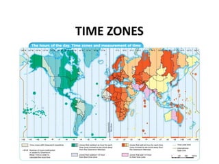
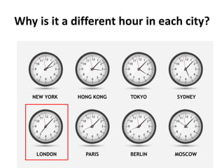
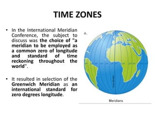
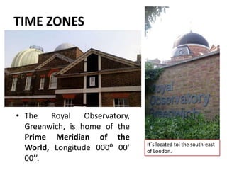
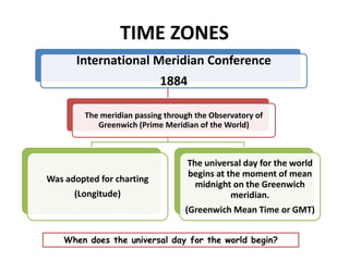
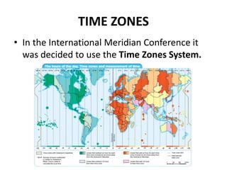
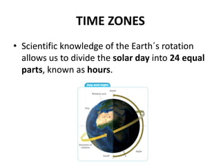
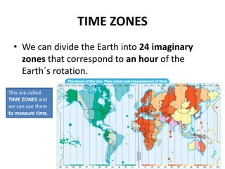
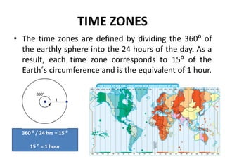
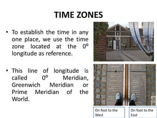
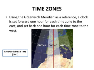
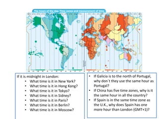
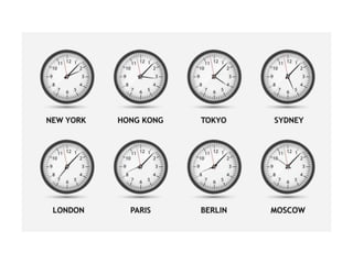
The document discusses time zones and how they were established. It explains that in 1884, the Prime Meridian passing through Greenwich Observatory in London was adopted as the international standard meridian. The world was divided into 24 time zones, each corresponding to 15 degrees of longitude and 1 hour. Greenwich Mean Time (GMT) was established as the universal day beginning at midnight on the Prime Meridian. This system allows different regions of the world to use coordinated time zones despite varying sunrise/sunset times due to the Earth's rotation.
A time zone is a region of the globe that observes a uniform standard time for legal, commercial, and social purposes.
The International Date Line (IDL) is an imaginary line of demarcation on the surface of the Earth that runs from the North Pole to the South Pole and demarcates the change of one calendar day to the next.
This is slide show created based on a tutorial hosted by Geography World and created by Mr. Bowerman. All credit for images and information go to them. I created this for use in a 4/5 grade gifted social studies and math lesson.
Lines of Latitude and Longitude – PowerPointYaryalitsa
PowerPoint on Lines of Latitude, Lines of Longitude, Climate Zones, Equinoxes, Solstices, The Three Norths, Prime Meridian, International Date Line, Greenwich Mean Time, Coordinated Universal Time.
Lines of Latitude and Longitude – Worksheet at:
http://www.slideshare.net/yaryalitsa/lines-of-latitude-and-longitude-worksheet
A coordinate system is a reference system used to represent the locations of geographic features, imagery, and observations, within a common geographic framework.
Coordinate systems enable geographic datasets to use common locations for integration.
The Map, Map Reading and Principles of Geography - World TourismCris dela Peña
Maps are the basic tools of the travel professional. Without them, it is next to impossible to locate cities or countries one may have never heard about. Bienvenido G. Claravall.
Message me if you want to have a copy of this presentation. Thanks.
The geographic coordinate system is a spherical or ellipsoidal coordinate system for measuring and communicating positions directly on the Earth as latitude and longitude. It is the simplest, oldest and most widely used of the various spatial reference systems that are in use, and forms the basis for most others
What is Universal Time (UTC)? Why is it for? How does UTC relate to Greenwich Mean Time (GMT) and Eastern Standard Time (EST)?
What is an Atomic clock? What is a leap-second? What is the Meridian and what is the International Date Line? Why are fractions of a second and UTC important in the 21st century?
Model Attribute Check Company Auto PropertyCeline George
In Odoo, the multi-company feature allows you to manage multiple companies within a single Odoo database instance. Each company can have its own configurations while still sharing common resources such as products, customers, and suppliers.
Biological screening of herbal drugs: Introduction and Need for
Phyto-Pharmacological Screening, New Strategies for evaluating
Natural Products, In vitro evaluation techniques for Antioxidants, Antimicrobial and Anticancer drugs. In vivo evaluation techniques
for Anti-inflammatory, Antiulcer, Anticancer, Wound healing, Antidiabetic, Hepatoprotective, Cardio protective, Diuretics and
Antifertility, Toxicity studies as per OECD guidelines
The Roman Empire A Historical Colossus.pdfkaushalkr1407
The Roman Empire, a vast and enduring power, stands as one of history's most remarkable civilizations, leaving an indelible imprint on the world. It emerged from the Roman Republic, transitioning into an imperial powerhouse under the leadership of Augustus Caesar in 27 BCE. This transformation marked the beginning of an era defined by unprecedented territorial expansion, architectural marvels, and profound cultural influence.
The empire's roots lie in the city of Rome, founded, according to legend, by Romulus in 753 BCE. Over centuries, Rome evolved from a small settlement to a formidable republic, characterized by a complex political system with elected officials and checks on power. However, internal strife, class conflicts, and military ambitions paved the way for the end of the Republic. Julius Caesar’s dictatorship and subsequent assassination in 44 BCE created a power vacuum, leading to a civil war. Octavian, later Augustus, emerged victorious, heralding the Roman Empire’s birth.
Under Augustus, the empire experienced the Pax Romana, a 200-year period of relative peace and stability. Augustus reformed the military, established efficient administrative systems, and initiated grand construction projects. The empire's borders expanded, encompassing territories from Britain to Egypt and from Spain to the Euphrates. Roman legions, renowned for their discipline and engineering prowess, secured and maintained these vast territories, building roads, fortifications, and cities that facilitated control and integration.
The Roman Empire’s society was hierarchical, with a rigid class system. At the top were the patricians, wealthy elites who held significant political power. Below them were the plebeians, free citizens with limited political influence, and the vast numbers of slaves who formed the backbone of the economy. The family unit was central, governed by the paterfamilias, the male head who held absolute authority.
Culturally, the Romans were eclectic, absorbing and adapting elements from the civilizations they encountered, particularly the Greeks. Roman art, literature, and philosophy reflected this synthesis, creating a rich cultural tapestry. Latin, the Roman language, became the lingua franca of the Western world, influencing numerous modern languages.
Roman architecture and engineering achievements were monumental. They perfected the arch, vault, and dome, constructing enduring structures like the Colosseum, Pantheon, and aqueducts. These engineering marvels not only showcased Roman ingenuity but also served practical purposes, from public entertainment to water supply.
A Strategic Approach: GenAI in EducationPeter Windle
Artificial Intelligence (AI) technologies such as Generative AI, Image Generators and Large Language Models have had a dramatic impact on teaching, learning and assessment over the past 18 months. The most immediate threat AI posed was to Academic Integrity with Higher Education Institutes (HEIs) focusing their efforts on combating the use of GenAI in assessment. Guidelines were developed for staff and students, policies put in place too. Innovative educators have forged paths in the use of Generative AI for teaching, learning and assessments leading to pockets of transformation springing up across HEIs, often with little or no top-down guidance, support or direction.
This Gasta posits a strategic approach to integrating AI into HEIs to prepare staff, students and the curriculum for an evolving world and workplace. We will highlight the advantages of working with these technologies beyond the realm of teaching, learning and assessment by considering prompt engineering skills, industry impact, curriculum changes, and the need for staff upskilling. In contrast, not engaging strategically with Generative AI poses risks, including falling behind peers, missed opportunities and failing to ensure our graduates remain employable. The rapid evolution of AI technologies necessitates a proactive and strategic approach if we are to remain relevant.
How to Make a Field invisible in Odoo 17Celine George
It is possible to hide or invisible some fields in odoo. Commonly using “invisible” attribute in the field definition to invisible the fields. This slide will show how to make a field invisible in odoo 17.
2024.06.01 Introducing a competency framework for languag learning materials ...Sandy Millin
http://sandymillin.wordpress.com/iateflwebinar2024
Published classroom materials form the basis of syllabuses, drive teacher professional development, and have a potentially huge influence on learners, teachers and education systems. All teachers also create their own materials, whether a few sentences on a blackboard, a highly-structured fully-realised online course, or anything in between. Despite this, the knowledge and skills needed to create effective language learning materials are rarely part of teacher training, and are mostly learnt by trial and error.
Knowledge and skills frameworks, generally called competency frameworks, for ELT teachers, trainers and managers have existed for a few years now. However, until I created one for my MA dissertation, there wasn’t one drawing together what we need to know and do to be able to effectively produce language learning materials.
This webinar will introduce you to my framework, highlighting the key competencies I identified from my research. It will also show how anybody involved in language teaching (any language, not just English!), teacher training, managing schools or developing language learning materials can benefit from using the framework.
Francesca Gottschalk - How can education support child empowerment.pptxEduSkills OECD
Francesca Gottschalk from the OECD’s Centre for Educational Research and Innovation presents at the Ask an Expert Webinar: How can education support child empowerment?
Read| The latest issue of The Challenger is here! We are thrilled to announce that our school paper has qualified for the NATIONAL SCHOOLS PRESS CONFERENCE (NSPC) 2024. Thank you for your unwavering support and trust. Dive into the stories that made us stand out!
3. TIME ZONES
• One of the consequences of
the Earth´s rotation is the
existence of the hours of the
day.
• The Sun does not strike on the
Earth´s surface in the same
way and at the same time.
Consequently, each part of the
Earth has a different hour in
relation of the illumination of
the Sun.
Why does each part of the Earth has a different hour?
4. TIME ZONES
• Until the 19th century
each city had a clock
with its own hour.
• Consequently, it was
difficult to organise the
means of transport
among cities and
countries.
5. TIME ZONES
• In October 1884, the International Meridian
Conference was held in Washington, D.C., in
the United States, to determine a prime meridian for
international use to establish the mean time in the
world.
6. TIME ZONES
• In the International Meridian
Conference, the subject to
discuss was the choice of "a
meridian to be employed as
a common zero of longitude
and standard of time
reckoning throughout the
world".
• It resulted in selection of the
Greenwich Meridian as an
international standard for
zero degrees longitude.
7. TIME ZONES
• The Royal Observatory,
Greenwich, is home of the
Prime Meridian of the
World, Longitude 000⁰ 00’
00’’.
It´s located toi the south-east
of London.
8. TIME ZONES
International Meridian Conference
1884
The meridian passing through the Observatory of
Greenwich (Prime Meridian of the World)
Was adopted for charting
(Longitude)
The universal day for the world
begins at the moment of mean
midnight on the Greenwich
meridian.
(Greenwich Mean Time or GMT)
When does the universal day for the world begin?
9. TIME ZONES
• In the International Meridian Conference it
was decided to use the Time Zones System.
10. TIME ZONES
• Scientific knowledge of the Earth´s rotation
allows us to divide the solar day into 24 equal
parts, known as hours.
11. TIME ZONES
• We can divide the Earth into 24 imaginary
zones that correspond to an hour of the
Earth´s rotation.
This are called
TIME ZONES and
we can use them
to measure time.
12. TIME ZONES
• The time zones are defined by dividing the 360⁰ of
the earthly sphere into the 24 hours of the day. As a
result, each time zone corresponds to 15⁰ of the
Earth´s circumference and is the equivalent of 1 hour.
360 ⁰ / 24 hrs = 15 ⁰
15 ⁰ = 1 hour
13. TIME ZONES
• To establish the time in any
one place, we use the time
zone located at the 0⁰
longitude as reference.
• This line of longitude is
called 0⁰ Meridian,
Greenwich Meridian or
Prime Meridian of the
World.
On foot to the
West
On foot to the
East
14. TIME ZONES
• Using the Greenwich Meridian as a reference, a clock
is set forward one hour for each time zone to the
east, and set back one hour for each time zone to the
west.
Greenwich Mean Time
(GMT)
15. If it is midnight in London:
• What time is it in New York?
• What time is it in Hong Kong?
• What time is it in Tokyo?
• What time is it in Sidney?
• What time is it in Paris?
• What time is it in Berlin?
• What time is it in Moscow?
• If Galicia is to the north of Portugal,
why don´t they use the same hour as
Portugal?
• If China has five time zones, why is it
the same hour in all the country?
• If Spain is in the same time zone as
the U.K., why does Spain has one
more hour than London (GMT+1)?