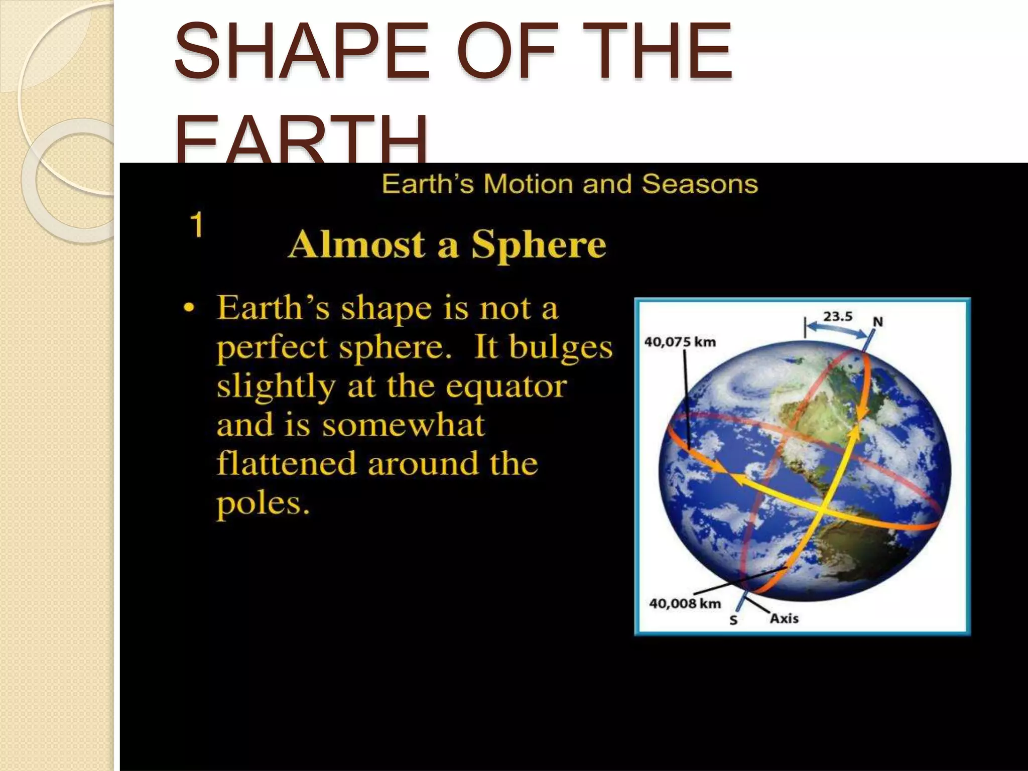
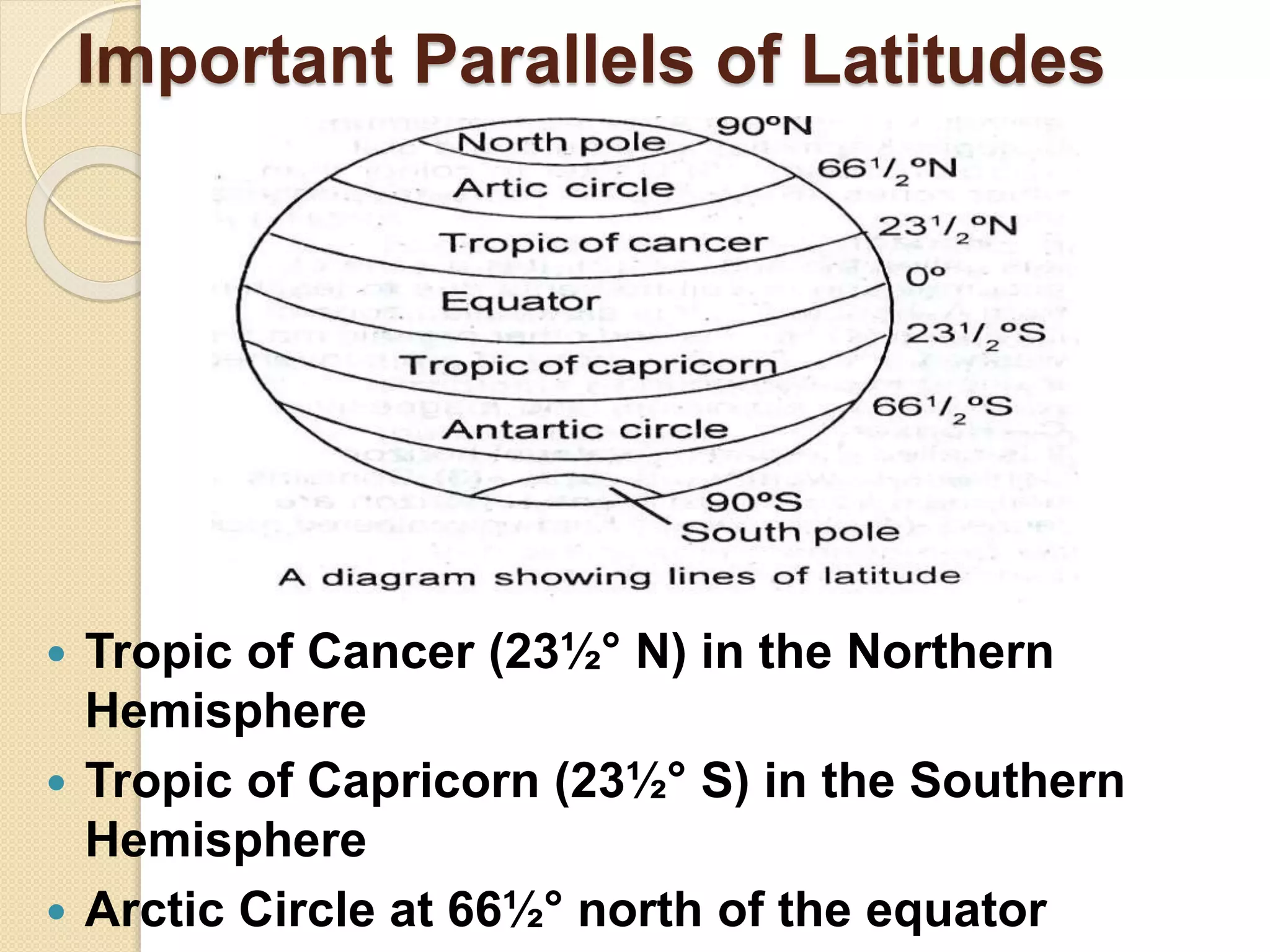
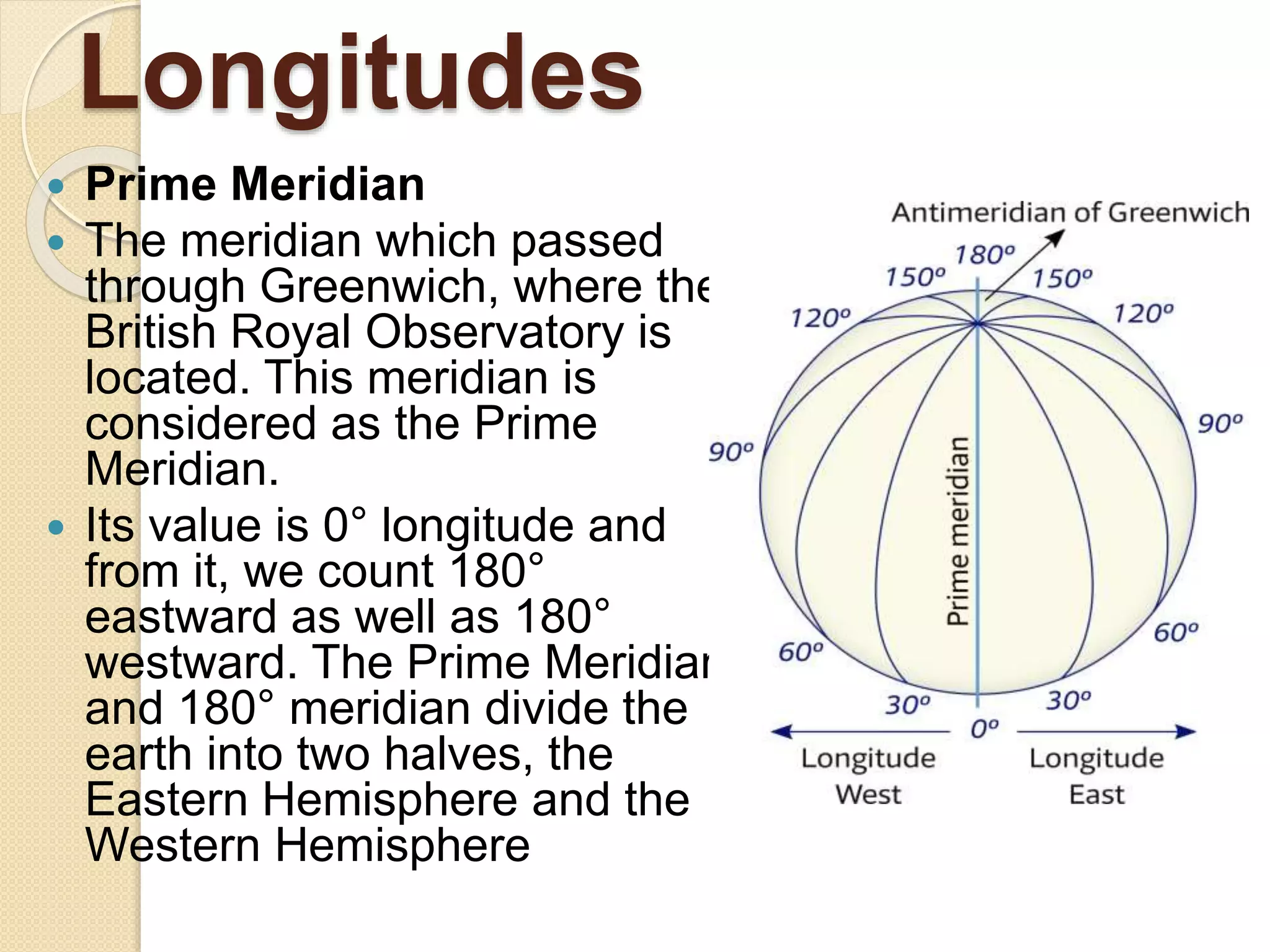
GLOBE:
LATTITUDES
AND
LONGITUTES
SHAPE OF THE
EARTH
Equator
 Equator is an imaginary
line running on the
globe that divides it
into two equal parts.
 The northern half of the
earth is known as the
Northern Hemisphere
and Southern half is
known as the Southern
Hemisphere.
Parallels of latitudes
 Parallels of latitudes are parallel circles from the
equator up to the poles.
 They are measured in degrees.
 The equator represents the zero degrees latitude. Its
distance from the equator to either of the poles is one-
fourth of a circle round the earth, it will measure ¼th
of 360 degrees, i.e. 90°. Thus, 90 degrees north
latitude marks the North Pole and 90 degrees south
latitude marks the South Pole
Important Parallels of Latitudes
 Tropic of Cancer (23½° N) in the Northern
Hemisphere
 Tropic of Capricorn (23½° S) in the Southern
Hemisphere
 Arctic Circle at 66½° north of the equator
ZONES OF THE EARTH
 Torrid Zone
 The mid-day sun is exactly overhead at least once
a year on all latitudes in between the Tropic of
Cancer and the Tropic of Capricorn. It, therefore,
receives the maximum heat.
 Temperate Zones
 The mid-day sun never shines overhead on any
latitude beyond the Tropic of Cancer and the
Tropic of Capricorn. The angle of the sun’s rays
goes on decreasing towards the poles. They have
moderate temperatures.
 Frigid Zones
 Areas lying between the Arctic Circle and the
North Pole in the Northern Hemisphere and the
Antarctic Circle and the South Pole in the
Southern Hemisphere, are very cold. It is because
here the sun does not rise much above the
horizon.
Longitudes
 Prime Meridian
 The meridian which passed
through Greenwich, where the
British Royal Observatory is
located. This meridian is
considered as the Prime
Meridian.
 Its value is 0° longitude and
from it, we count 180°
eastward as well as 180°
westward. The Prime Meridian
and 180° meridian divide the
earth into two halves, the
Eastern Hemisphere and the
Western Hemisphere
Longitude and Time
 The best means of measuring time is by the
movement of the earth, the moon, and the planets.
The sun regularly rises and sets every day.
 When the Prime Meridian of Greenwich has the sun
at the highest point in the sky, all the places along
this meridian will have mid-day or noon.
 As the earth rotates from west to east, those
places east of Greenwich will be ahead of
Greenwich time and those to the west will be
behind it.
 It can be calculated this way- The earth rotates
360° in about 24 hours, which means 15° an hour
or 1° in four minutes. Thus, when it is noon at
Greenwich, the time at 15° east of Greenwich will
be 15 × 4 = 60 minutes, i.e., 1 hour ahead of
Greenwich time, But at 15° west of Greenwich, the
time will be behind Greenwich time by one hour
Why do we have
Standard Time?
 The local time of places which are on
different meridians is bound to differ.
 In India, for instance, there will be a
difference of about 1 hour and 45 minutes
in the local times of Dwarka in Gujarat
and Dibrugarh in Assam.
 In India, the longitude of 82½° E (82° 30’E)
is treated as the standard meridian. The
local time at this meridian is taken as the
standard time for the whole country. It is
known as the Indian Standard Time (IST).
Presented by- Urvashi Miglani

Globe: lattitudes and longitudes

  • 1.
  • 2.
  • 3.
    Equator  Equator isan imaginary line running on the globe that divides it into two equal parts.  The northern half of the earth is known as the Northern Hemisphere and Southern half is known as the Southern Hemisphere.
  • 4.
    Parallels of latitudes Parallels of latitudes are parallel circles from the equator up to the poles.  They are measured in degrees.  The equator represents the zero degrees latitude. Its distance from the equator to either of the poles is one- fourth of a circle round the earth, it will measure ¼th of 360 degrees, i.e. 90°. Thus, 90 degrees north latitude marks the North Pole and 90 degrees south latitude marks the South Pole
  • 5.
    Important Parallels ofLatitudes  Tropic of Cancer (23½° N) in the Northern Hemisphere  Tropic of Capricorn (23½° S) in the Southern Hemisphere  Arctic Circle at 66½° north of the equator
  • 6.
  • 7.
     Torrid Zone The mid-day sun is exactly overhead at least once a year on all latitudes in between the Tropic of Cancer and the Tropic of Capricorn. It, therefore, receives the maximum heat.  Temperate Zones  The mid-day sun never shines overhead on any latitude beyond the Tropic of Cancer and the Tropic of Capricorn. The angle of the sun’s rays goes on decreasing towards the poles. They have moderate temperatures.  Frigid Zones  Areas lying between the Arctic Circle and the North Pole in the Northern Hemisphere and the Antarctic Circle and the South Pole in the Southern Hemisphere, are very cold. It is because here the sun does not rise much above the horizon.
  • 8.
    Longitudes  Prime Meridian The meridian which passed through Greenwich, where the British Royal Observatory is located. This meridian is considered as the Prime Meridian.  Its value is 0° longitude and from it, we count 180° eastward as well as 180° westward. The Prime Meridian and 180° meridian divide the earth into two halves, the Eastern Hemisphere and the Western Hemisphere
  • 9.
    Longitude and Time The best means of measuring time is by the movement of the earth, the moon, and the planets. The sun regularly rises and sets every day.  When the Prime Meridian of Greenwich has the sun at the highest point in the sky, all the places along this meridian will have mid-day or noon.  As the earth rotates from west to east, those places east of Greenwich will be ahead of Greenwich time and those to the west will be behind it.  It can be calculated this way- The earth rotates 360° in about 24 hours, which means 15° an hour or 1° in four minutes. Thus, when it is noon at Greenwich, the time at 15° east of Greenwich will be 15 × 4 = 60 minutes, i.e., 1 hour ahead of Greenwich time, But at 15° west of Greenwich, the time will be behind Greenwich time by one hour
  • 11.
    Why do wehave Standard Time?  The local time of places which are on different meridians is bound to differ.  In India, for instance, there will be a difference of about 1 hour and 45 minutes in the local times of Dwarka in Gujarat and Dibrugarh in Assam.  In India, the longitude of 82½° E (82° 30’E) is treated as the standard meridian. The local time at this meridian is taken as the standard time for the whole country. It is known as the Indian Standard Time (IST).
  • 12.