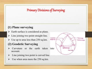
This document provides an overview of surveying. It defines surveying as determining relative positions of points on Earth's surface by measuring horizontal distances, angles, and details. The objectives are to prepare maps and plans showing positions of objects and engineering features. There are different types of surveying based on instruments used, methods, purposes, and areas surveyed. Primary divisions are plane and geodetic surveying. Fundamental principles include working from whole to part and locating new stations by two measurements from fixed references. Surveying has various applications like topographical, cadastral, and engineering mapping.