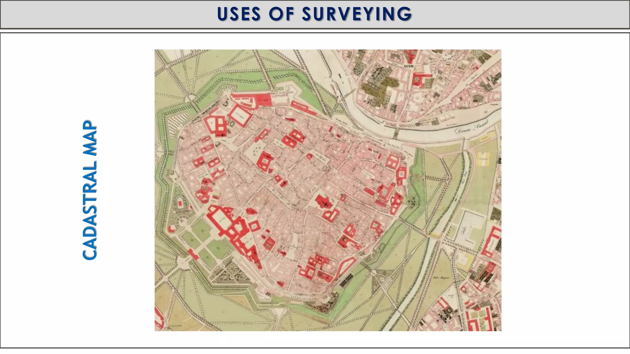
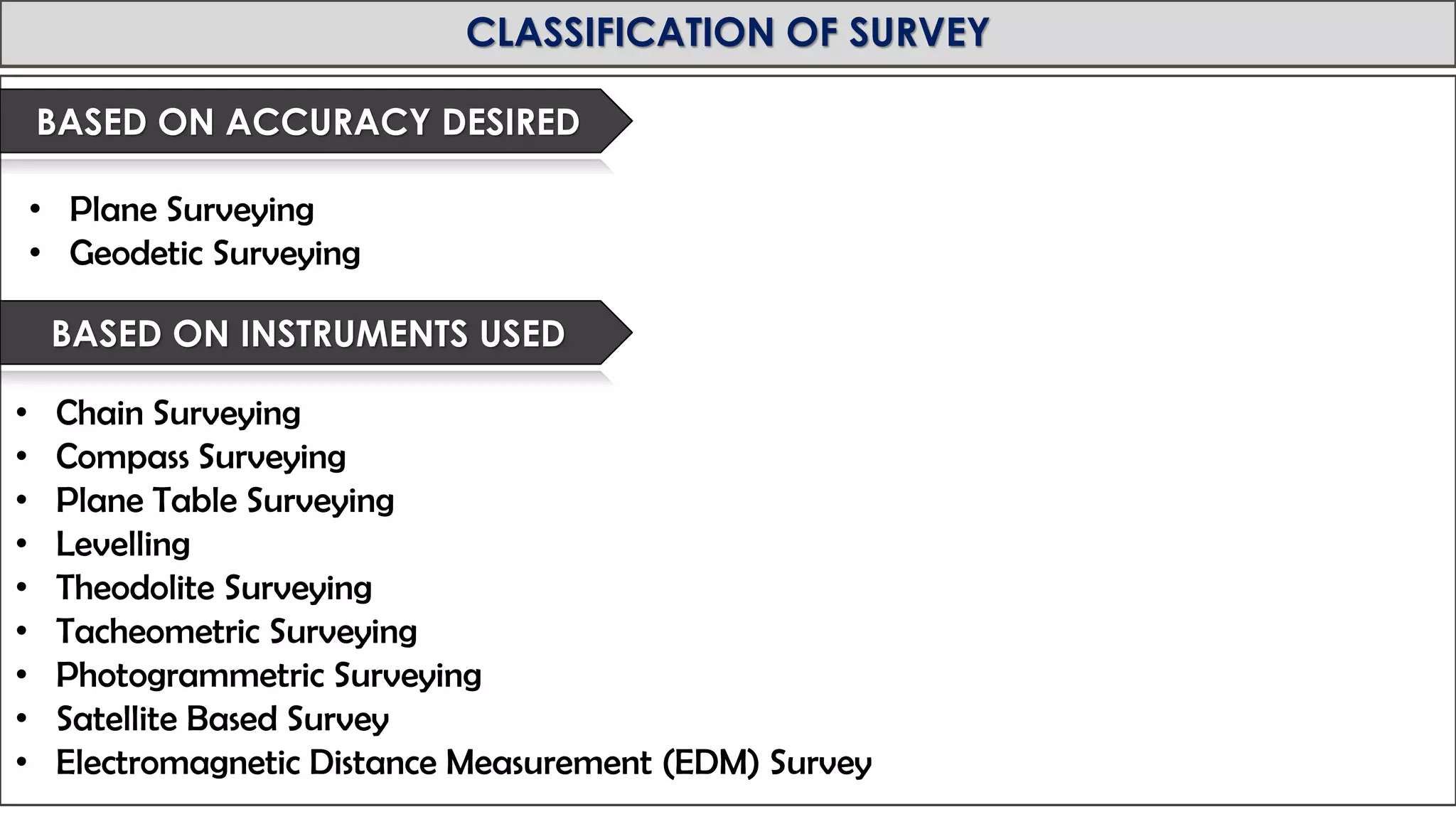
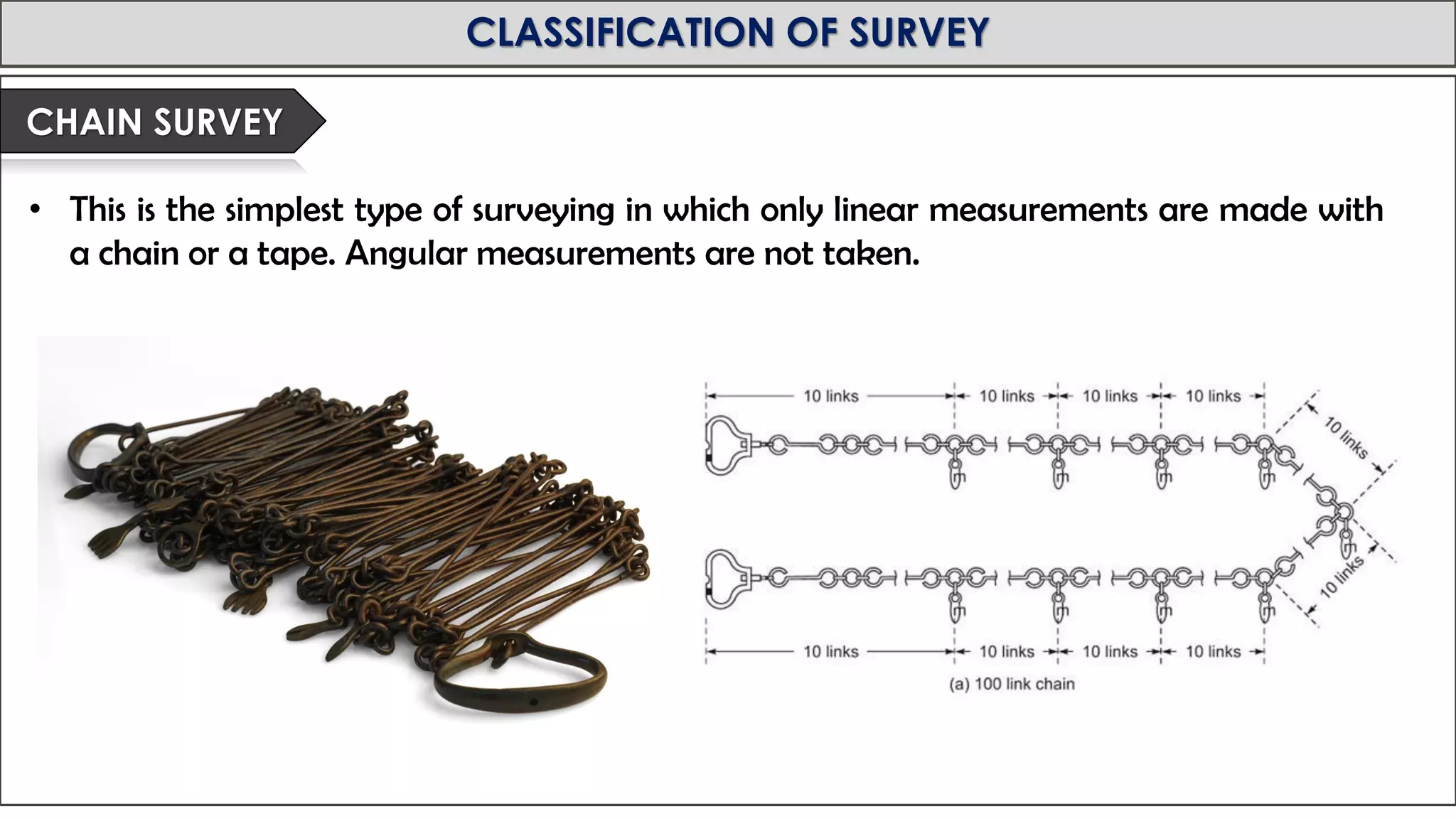
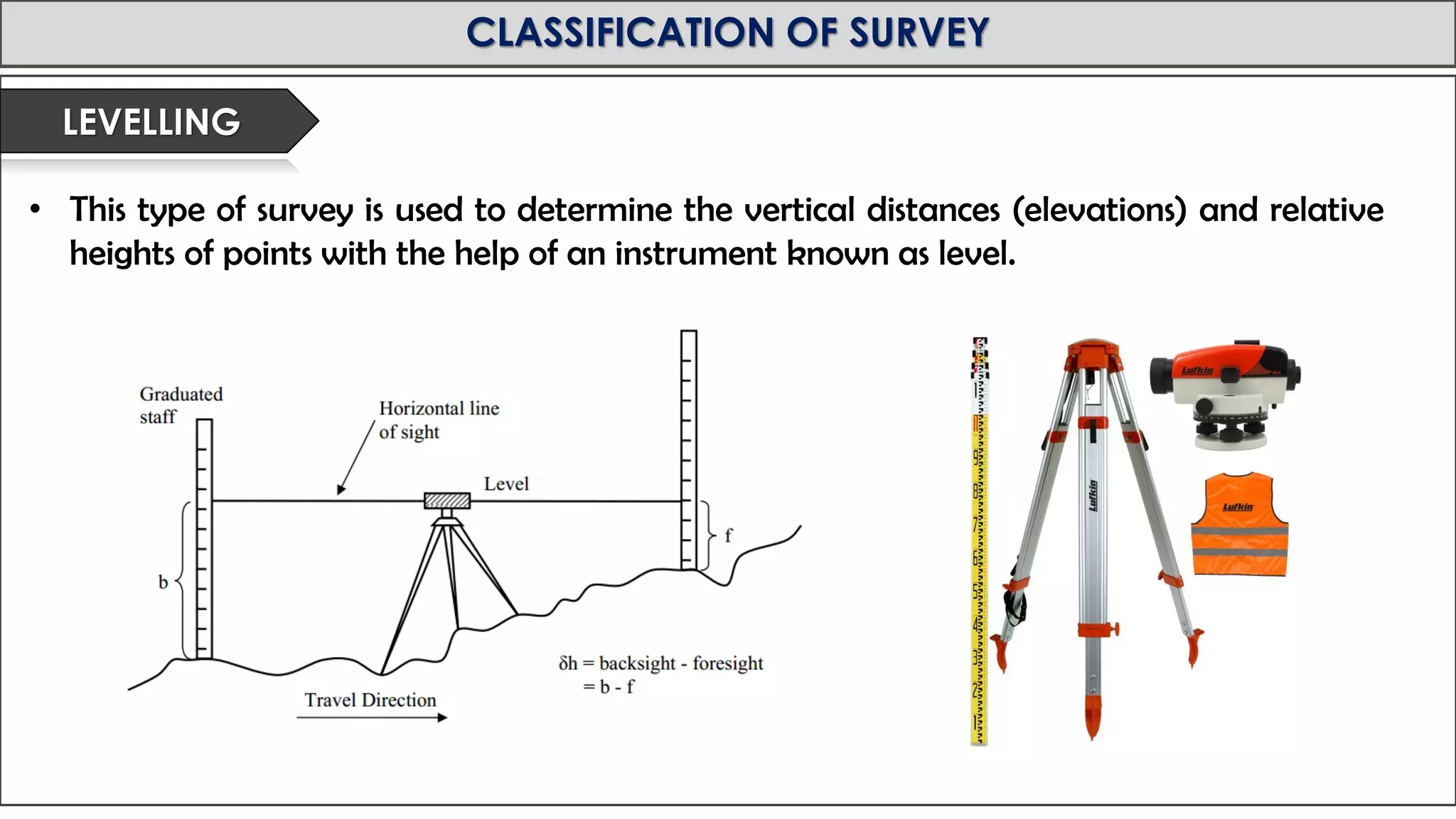
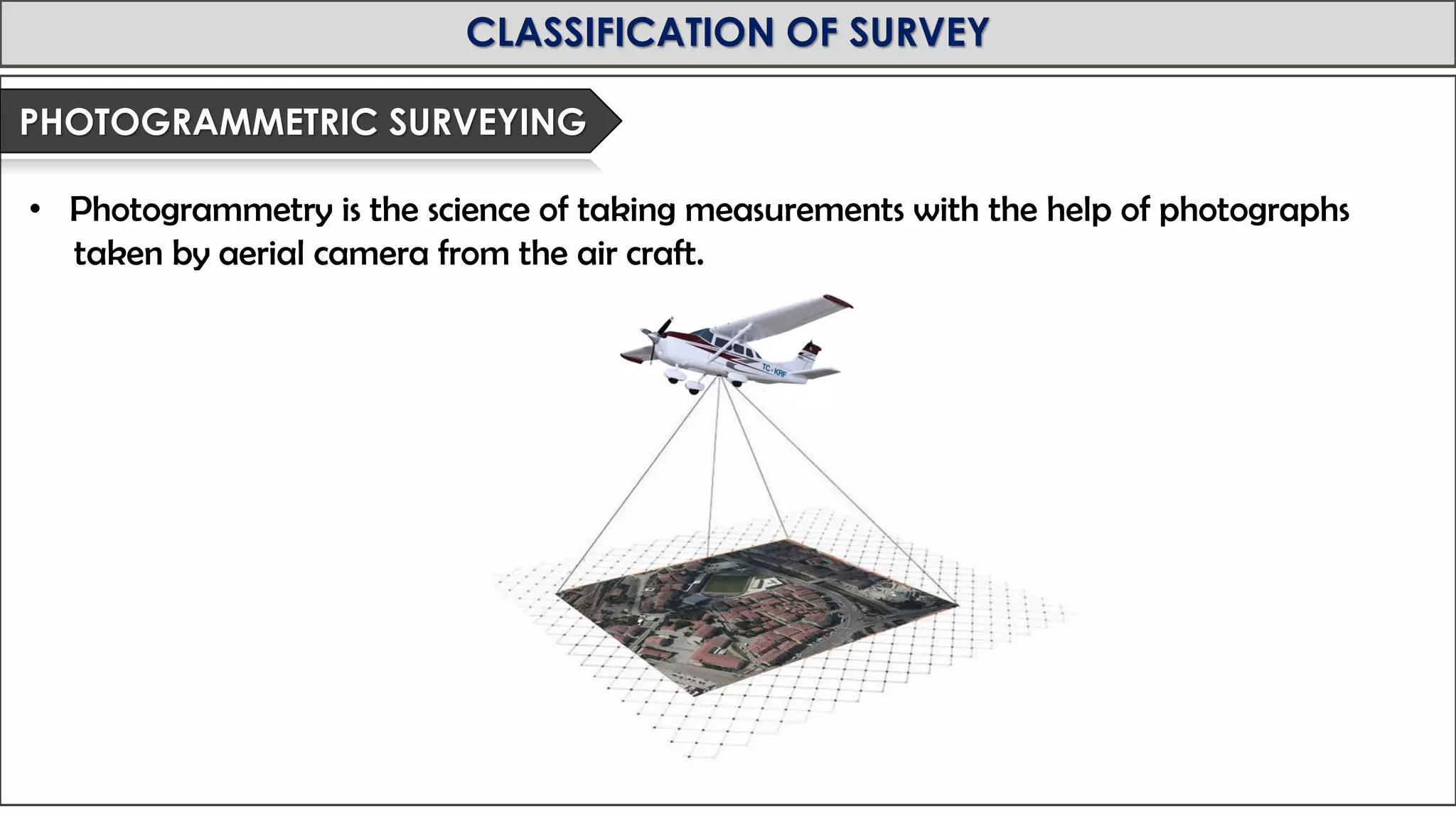
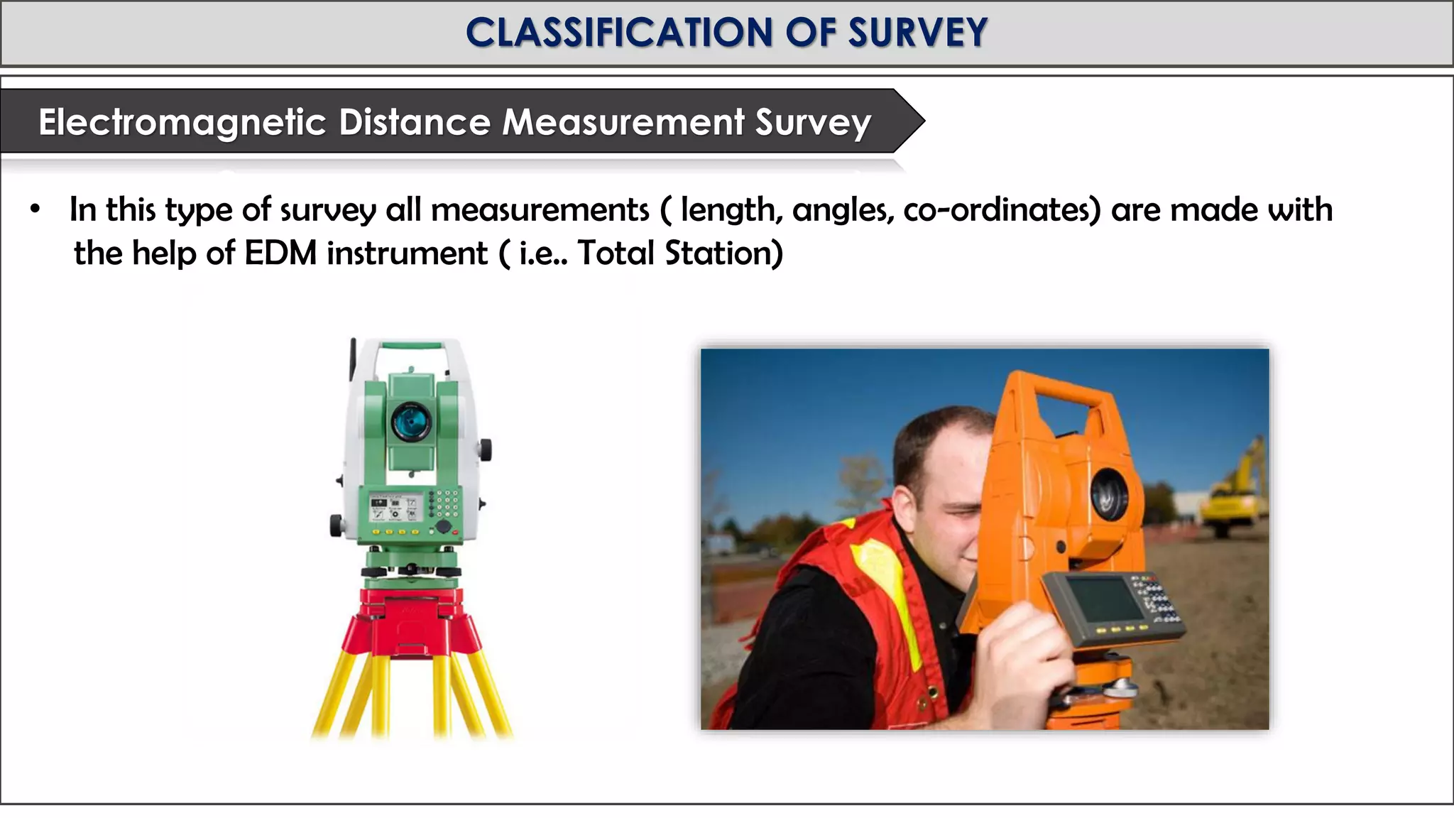
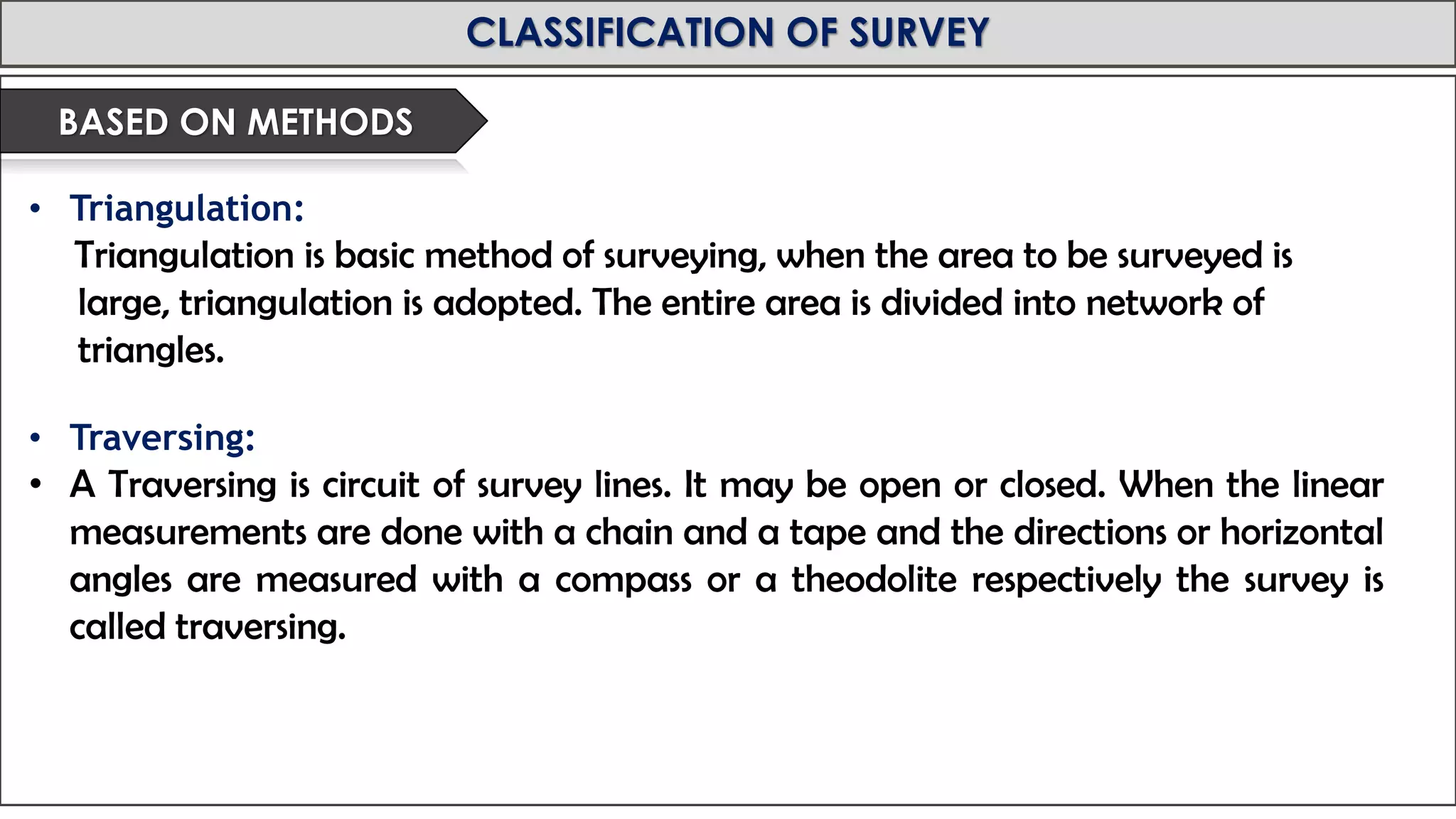
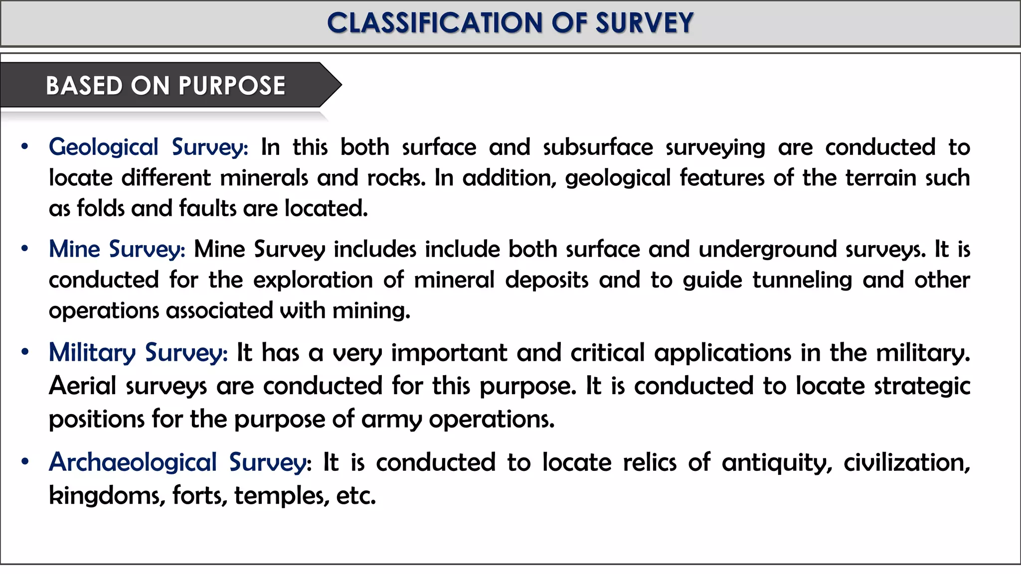
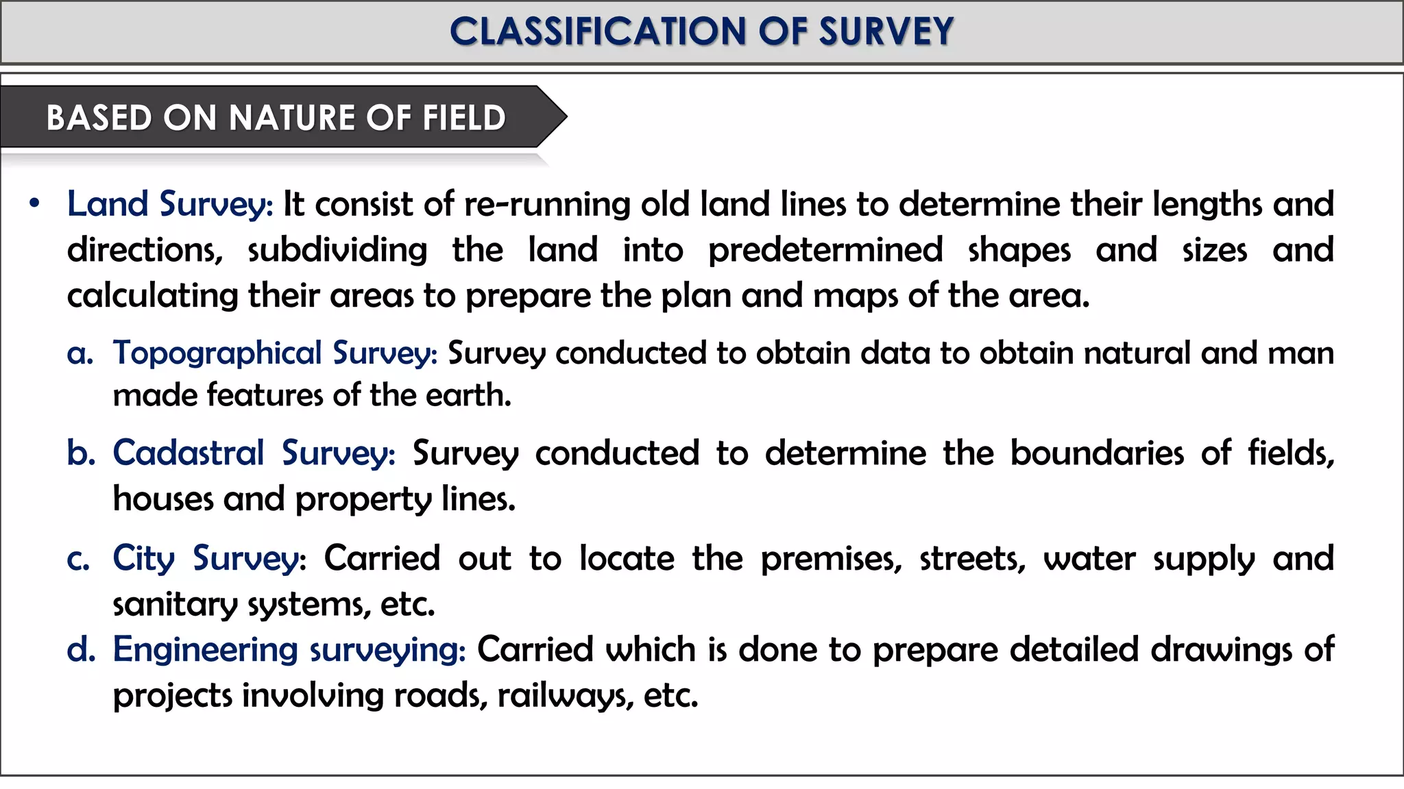
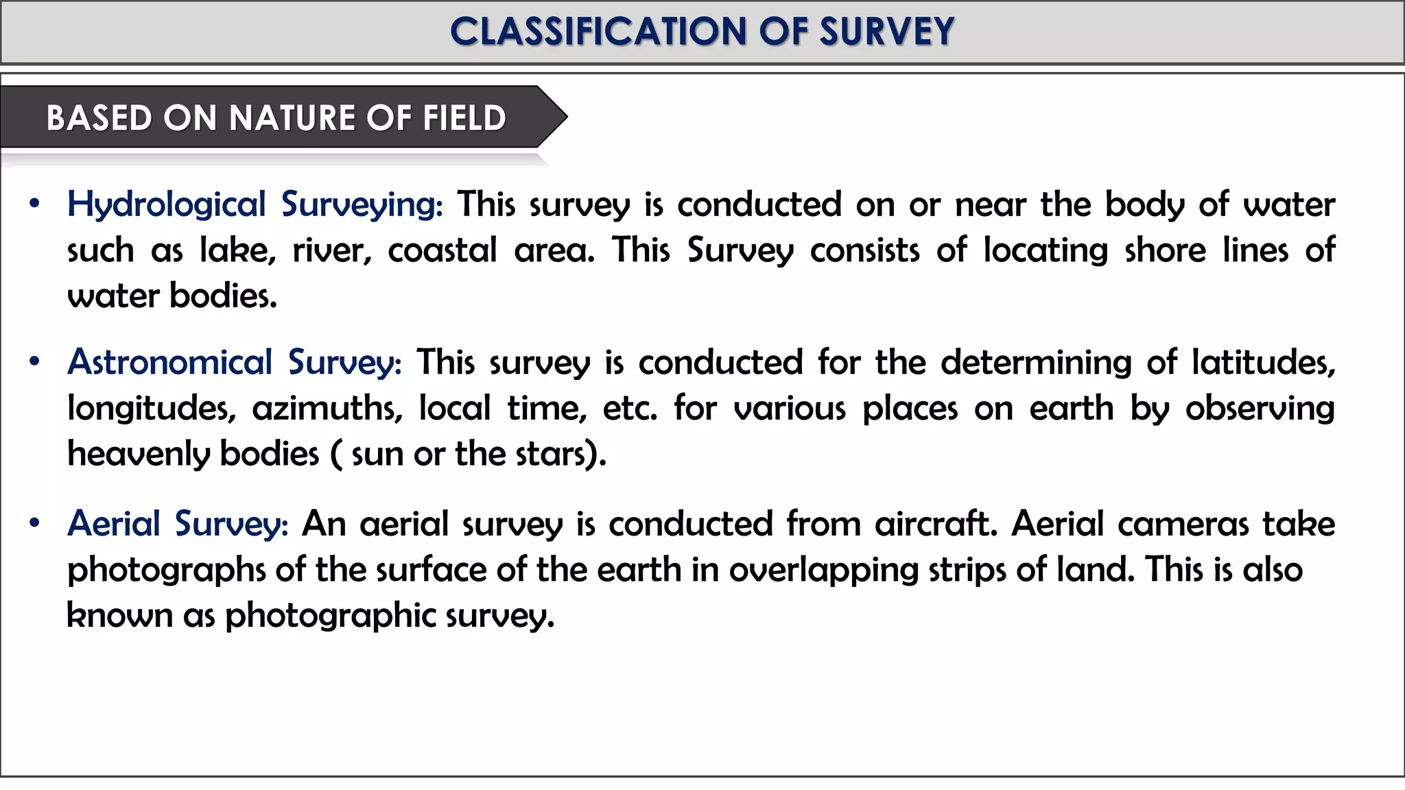
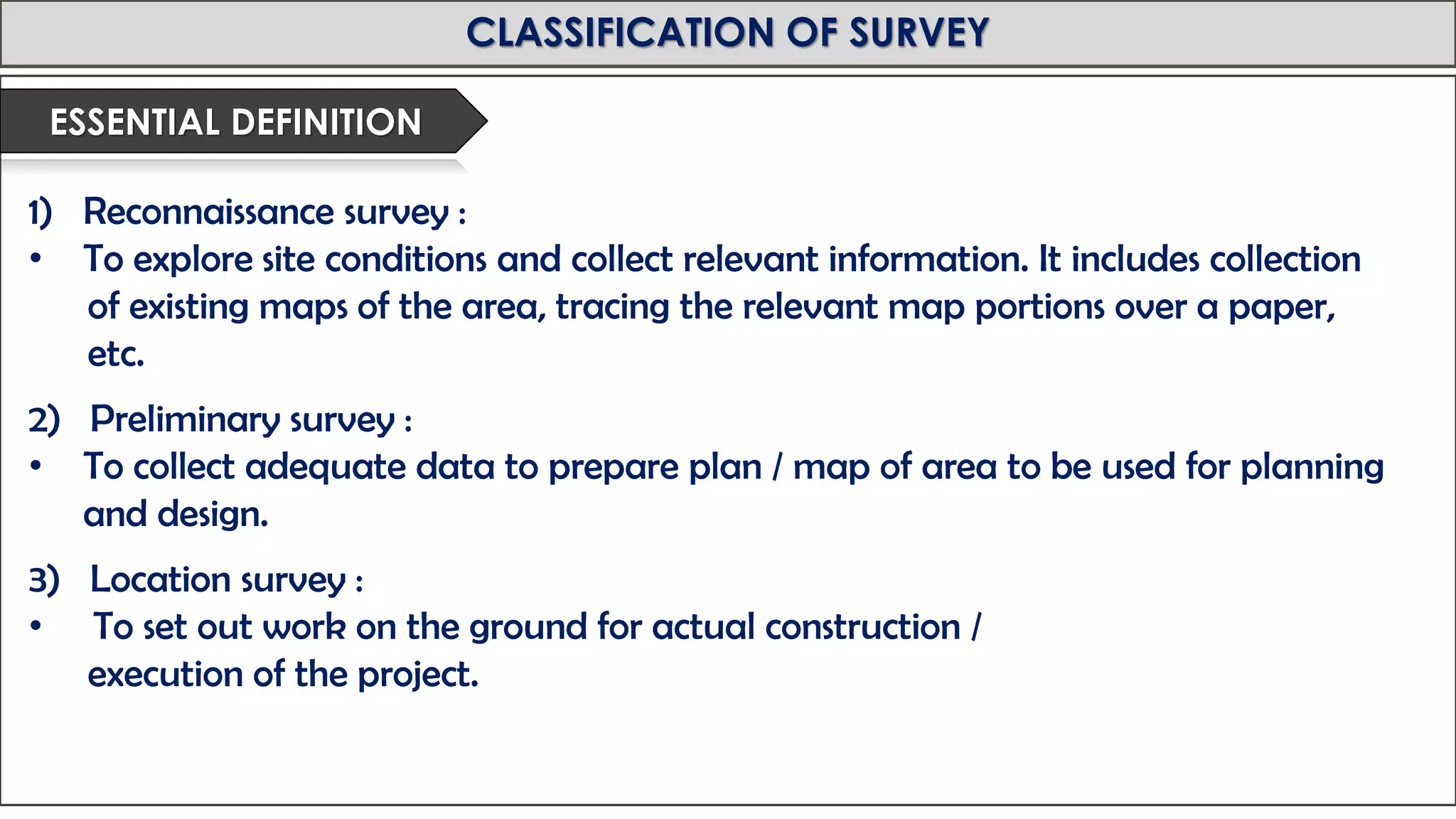
Royal University of Bhutan
Jigme Namgyel Engineering College
Department of Civil Engineering & Surveying
Tutor : Phurba Tamang
Designation: Associate lecturer
Department of Civil Engineering and Surveying
“ Introduction to Surveying ”
MODULE: SURVEYING
Spring Semester 2019
MID-TERM REVIEW, 2017
UNIT 1: INTRODUCTION TO SURVEYING
• Surveying is the art of determining the relative positions of
different objects on the surface of the earth by measuring the
horizontal distances between them and preparing a map to
any suitable scale.
• Surveying is the science and art of determining the relative
positions of various points on, above or beneath the surface of
the earth by measuring the horizontal and vertical distances,
angles taking the details of these points by preparing a map
to suitable scale.
• Engineering Surveying is defined as those activities involved in
the planning and execution of surveys for location, design,
construction, operation and maintenance of civil and other
engineering works.
MID-TERM REVIEW, 2017
OBJECTIVES OF SURVEYING
• To prepare a map.
• To show the relative positions of the objects on the surface of the earth.
• To show the natural and man made features of a country such as towns, villages, roads,
railways, rivers, etc.
• To represent the details of various engineering works such as roads, railways, irrigation
canals, etc.
MID-TERM REVIEW, 2017
USES OF SURVEYING
• To prepare a Topographical Map which shows the hills, valleys, rivers, villages,
towns, forests, etc.
• To prepare a Cadastral map showing the boundaries of fields, houses and other
properties.
• To prepare an Engineering map which shows the details of engineering works
such as roads, railways, dams, irrigation canals, etc.
• To prepare a Contour Map to determine the topography of the area to find out
the best possible route for roads, canals, railways, bridges, etc.
• To prepare Military Maps, Geological Maps, Archaeological Maps, etc.
MID-TERM REVIEW, 2017
USES OF SURVEYING
TOPOGRAPHICALMAP
MID-TERM REVIEW, 2017
USES OF SURVEYING
CADASTRALMAP
MID-TERM REVIEW, 2017
USES OF SURVEYING
CADASTRALMAP
MID-TERM REVIEW, 2017
USES OF SURVEYING
EGINEERINGMAPS
MID-TERM REVIEW, 2017
USES OF SURVEYING
CONT0URMAPS
MID-TERM REVIEW, 2017
PRIMARY DIVISIONS OF SURVEYING
• Type of surveying in which the earth’s surface is considered as plane and curvature of
the earth is not taken into consideration.
• In such surveying a line joining two points is considered to be straight.
• It is carried out on an area less than 250 square kilometer.
• It uses normal instruments like chain, measuring tape, theodolite, etc. to locate points
on earth
PLANE SURVEYING
GEODETIC SURVEYING
• Type of surveying in which curvature of the earth is taken into consideration.
• It is extend over a large area and conducted with a high degree of accuracy.
• In such surveying a line joining two points is considered to a curve line (arc)
• Geodetic surveying is done on an area of more than 250 square kilometer.
• It uses more precise instruments and technology like GPS.
MID-TERM REVIEW, 2017
PRIMARY DIVISIONS OF SURVEYING
MID-TERM REVIEW, 2017
CLASSIFICATION OF SURVEY
• Plane Surveying
• Geodetic Surveying
BASED ON ACCURACY DESIRED
• Chain Surveying
• Compass Surveying
• Plane Table Surveying
• Levelling
• Theodolite Surveying
• Tacheometric Surveying
• Photogrammetric Surveying
• Satellite Based Survey
• Electromagnetic Distance Measurement (EDM) Survey
BASED ON INSTRUMENTS USED
MID-TERM REVIEW, 2017
CLASSIFICATION OF SURVEY
• This is the simplest type of surveying in which only linear measurements are made with
a chain or a tape. Angular measurements are not taken.
CHAIN SURVEY
MID-TERM REVIEW, 2017
CLASSIFICATION OF SURVEY
• In this survey the angles are measured using a magnetic compass.
COMPASS SURVEY
MID-TERM REVIEW, 2017
CLASSIFICATION OF SURVEY
• It is a graphical method of surveying in which field works and plotting both are done
simultaneously.
PLANE TABLE SURVEY
MID-TERM REVIEW, 2017
CLASSIFICATION OF SURVEY
• This type of survey is used to determine the vertical distances (elevations) and relative
heights of points with the help of an instrument known as level.
LEVELLING
MID-TERM REVIEW, 2017
CLASSIFICATION OF SURVEY
• In theodolite survey the horizontal angles are measured with the theodolite more
precisely than compass and the linear measurements are made with a chain or tape.
THEODEOLITE SURVEYING
MID-TERM REVIEW, 2017
CLASSIFICATION OF SURVEY
• Photogrammetry is the science of taking measurements with the help of photographs
taken by aerial camera from the air craft.
PHOTOGRAMMETRIC SURVEYING
MID-TERM REVIEW, 2017
CLASSIFICATION OF SURVEY
• In this type of survey all measurements ( length, angles, co-ordinates) are made with
the help of EDM instrument ( i.e.. Total Station)
Electromagnetic Distance Measurement Survey
MID-TERM REVIEW, 2017
CLASSIFICATION OF SURVEY
• Triangulation:
Triangulation is basic method of surveying, when the area to be surveyed is
large, triangulation is adopted. The entire area is divided into network of
triangles.
• Traversing:
• A Traversing is circuit of survey lines. It may be open or closed. When the linear
measurements are done with a chain and a tape and the directions or horizontal
angles are measured with a compass or a theodolite respectively the survey is
called traversing.
BASED ON METHODS
MID-TERM REVIEW, 2017
CLASSIFICATION OF SURVEY
Triangulation
Open and Closed
Traversing
MID-TERM REVIEW, 2017
CLASSIFICATION OF SURVEY
• Geological Survey: In this both surface and subsurface surveying are conducted to
locate different minerals and rocks. In addition, geological features of the terrain such
as folds and faults are located.
• Mine Survey: Mine Survey includes include both surface and underground surveys. It is
conducted for the exploration of mineral deposits and to guide tunneling and other
operations associated with mining.
• Military Survey: It has a very important and critical applications in the military.
Aerial surveys are conducted for this purpose. It is conducted to locate strategic
positions for the purpose of army operations.
• Archaeological Survey: It is conducted to locate relics of antiquity, civilization,
kingdoms, forts, temples, etc.
BASED ON PURPOSE
MID-TERM REVIEW, 2017
CLASSIFICATION OF SURVEY
• Land Survey: It consist of re-running old land lines to determine their lengths and
directions, subdividing the land into predetermined shapes and sizes and
calculating their areas to prepare the plan and maps of the area.
a. Topographical Survey: Survey conducted to obtain data to obtain natural and man
made features of the earth.
b. Cadastral Survey: Survey conducted to determine the boundaries of fields,
houses and property lines.
c. City Survey: Carried out to locate the premises, streets, water supply and
sanitary systems, etc.
d. Engineering surveying: Carried which is done to prepare detailed drawings of
projects involving roads, railways, etc.
BASED ON NATURE OF FIELD
MID-TERM REVIEW, 2017
CLASSIFICATION OF SURVEY
• Hydrological Surveying: This survey is conducted on or near the body of water
such as lake, river, coastal area. This Survey consists of locating shore lines of
water bodies.
• Astronomical Survey: This survey is conducted for the determining of latitudes,
longitudes, azimuths, local time, etc. for various places on earth by observing
heavenly bodies ( sun or the stars).
• Aerial Survey: An aerial survey is conducted from aircraft. Aerial cameras take
photographs of the surface of the earth in overlapping strips of land. This is also
known as photographic survey.
BASED ON NATURE OF FIELD
MID-TERM REVIEW, 2017
CLASSIFICATION OF SURVEY
1) Reconnaissance survey :
• To explore site conditions and collect relevant information. It includes collection
of existing maps of the area, tracing the relevant map portions over a paper,
etc.
2) Preliminary survey :
• To collect adequate data to prepare plan / map of area to be used for planning
and design.
3) Location survey :
• To set out work on the ground for actual construction /
execution of the project.
ESSENTIAL DEFINITION
MID-TERM REVIEW, 2017

Introduction to Surveying

  • 2.
    Royal University ofBhutan Jigme Namgyel Engineering College Department of Civil Engineering & Surveying Tutor : Phurba Tamang Designation: Associate lecturer Department of Civil Engineering and Surveying “ Introduction to Surveying ” MODULE: SURVEYING Spring Semester 2019
  • 3.
    MID-TERM REVIEW, 2017 UNIT1: INTRODUCTION TO SURVEYING • Surveying is the art of determining the relative positions of different objects on the surface of the earth by measuring the horizontal distances between them and preparing a map to any suitable scale. • Surveying is the science and art of determining the relative positions of various points on, above or beneath the surface of the earth by measuring the horizontal and vertical distances, angles taking the details of these points by preparing a map to suitable scale. • Engineering Surveying is defined as those activities involved in the planning and execution of surveys for location, design, construction, operation and maintenance of civil and other engineering works.
  • 4.
    MID-TERM REVIEW, 2017 OBJECTIVESOF SURVEYING • To prepare a map. • To show the relative positions of the objects on the surface of the earth. • To show the natural and man made features of a country such as towns, villages, roads, railways, rivers, etc. • To represent the details of various engineering works such as roads, railways, irrigation canals, etc.
  • 5.
    MID-TERM REVIEW, 2017 USESOF SURVEYING • To prepare a Topographical Map which shows the hills, valleys, rivers, villages, towns, forests, etc. • To prepare a Cadastral map showing the boundaries of fields, houses and other properties. • To prepare an Engineering map which shows the details of engineering works such as roads, railways, dams, irrigation canals, etc. • To prepare a Contour Map to determine the topography of the area to find out the best possible route for roads, canals, railways, bridges, etc. • To prepare Military Maps, Geological Maps, Archaeological Maps, etc.
  • 6.
    MID-TERM REVIEW, 2017 USESOF SURVEYING TOPOGRAPHICALMAP
  • 7.
    MID-TERM REVIEW, 2017 USESOF SURVEYING CADASTRALMAP
  • 8.
    MID-TERM REVIEW, 2017 USESOF SURVEYING CADASTRALMAP
  • 9.
    MID-TERM REVIEW, 2017 USESOF SURVEYING EGINEERINGMAPS
  • 10.
    MID-TERM REVIEW, 2017 USESOF SURVEYING CONT0URMAPS
  • 11.
    MID-TERM REVIEW, 2017 PRIMARYDIVISIONS OF SURVEYING • Type of surveying in which the earth’s surface is considered as plane and curvature of the earth is not taken into consideration. • In such surveying a line joining two points is considered to be straight. • It is carried out on an area less than 250 square kilometer. • It uses normal instruments like chain, measuring tape, theodolite, etc. to locate points on earth PLANE SURVEYING GEODETIC SURVEYING • Type of surveying in which curvature of the earth is taken into consideration. • It is extend over a large area and conducted with a high degree of accuracy. • In such surveying a line joining two points is considered to a curve line (arc) • Geodetic surveying is done on an area of more than 250 square kilometer. • It uses more precise instruments and technology like GPS.
  • 12.
    MID-TERM REVIEW, 2017 PRIMARYDIVISIONS OF SURVEYING
  • 13.
    MID-TERM REVIEW, 2017 CLASSIFICATIONOF SURVEY • Plane Surveying • Geodetic Surveying BASED ON ACCURACY DESIRED • Chain Surveying • Compass Surveying • Plane Table Surveying • Levelling • Theodolite Surveying • Tacheometric Surveying • Photogrammetric Surveying • Satellite Based Survey • Electromagnetic Distance Measurement (EDM) Survey BASED ON INSTRUMENTS USED
  • 14.
    MID-TERM REVIEW, 2017 CLASSIFICATIONOF SURVEY • This is the simplest type of surveying in which only linear measurements are made with a chain or a tape. Angular measurements are not taken. CHAIN SURVEY
  • 15.
    MID-TERM REVIEW, 2017 CLASSIFICATIONOF SURVEY • In this survey the angles are measured using a magnetic compass. COMPASS SURVEY
  • 16.
    MID-TERM REVIEW, 2017 CLASSIFICATIONOF SURVEY • It is a graphical method of surveying in which field works and plotting both are done simultaneously. PLANE TABLE SURVEY
  • 17.
    MID-TERM REVIEW, 2017 CLASSIFICATIONOF SURVEY • This type of survey is used to determine the vertical distances (elevations) and relative heights of points with the help of an instrument known as level. LEVELLING
  • 18.
    MID-TERM REVIEW, 2017 CLASSIFICATIONOF SURVEY • In theodolite survey the horizontal angles are measured with the theodolite more precisely than compass and the linear measurements are made with a chain or tape. THEODEOLITE SURVEYING
  • 19.
    MID-TERM REVIEW, 2017 CLASSIFICATIONOF SURVEY • Photogrammetry is the science of taking measurements with the help of photographs taken by aerial camera from the air craft. PHOTOGRAMMETRIC SURVEYING
  • 20.
    MID-TERM REVIEW, 2017 CLASSIFICATIONOF SURVEY • In this type of survey all measurements ( length, angles, co-ordinates) are made with the help of EDM instrument ( i.e.. Total Station) Electromagnetic Distance Measurement Survey
  • 21.
    MID-TERM REVIEW, 2017 CLASSIFICATIONOF SURVEY • Triangulation: Triangulation is basic method of surveying, when the area to be surveyed is large, triangulation is adopted. The entire area is divided into network of triangles. • Traversing: • A Traversing is circuit of survey lines. It may be open or closed. When the linear measurements are done with a chain and a tape and the directions or horizontal angles are measured with a compass or a theodolite respectively the survey is called traversing. BASED ON METHODS
  • 22.
    MID-TERM REVIEW, 2017 CLASSIFICATIONOF SURVEY Triangulation Open and Closed Traversing
  • 23.
    MID-TERM REVIEW, 2017 CLASSIFICATIONOF SURVEY • Geological Survey: In this both surface and subsurface surveying are conducted to locate different minerals and rocks. In addition, geological features of the terrain such as folds and faults are located. • Mine Survey: Mine Survey includes include both surface and underground surveys. It is conducted for the exploration of mineral deposits and to guide tunneling and other operations associated with mining. • Military Survey: It has a very important and critical applications in the military. Aerial surveys are conducted for this purpose. It is conducted to locate strategic positions for the purpose of army operations. • Archaeological Survey: It is conducted to locate relics of antiquity, civilization, kingdoms, forts, temples, etc. BASED ON PURPOSE
  • 24.
    MID-TERM REVIEW, 2017 CLASSIFICATIONOF SURVEY • Land Survey: It consist of re-running old land lines to determine their lengths and directions, subdividing the land into predetermined shapes and sizes and calculating their areas to prepare the plan and maps of the area. a. Topographical Survey: Survey conducted to obtain data to obtain natural and man made features of the earth. b. Cadastral Survey: Survey conducted to determine the boundaries of fields, houses and property lines. c. City Survey: Carried out to locate the premises, streets, water supply and sanitary systems, etc. d. Engineering surveying: Carried which is done to prepare detailed drawings of projects involving roads, railways, etc. BASED ON NATURE OF FIELD
  • 25.
    MID-TERM REVIEW, 2017 CLASSIFICATIONOF SURVEY • Hydrological Surveying: This survey is conducted on or near the body of water such as lake, river, coastal area. This Survey consists of locating shore lines of water bodies. • Astronomical Survey: This survey is conducted for the determining of latitudes, longitudes, azimuths, local time, etc. for various places on earth by observing heavenly bodies ( sun or the stars). • Aerial Survey: An aerial survey is conducted from aircraft. Aerial cameras take photographs of the surface of the earth in overlapping strips of land. This is also known as photographic survey. BASED ON NATURE OF FIELD
  • 26.
    MID-TERM REVIEW, 2017 CLASSIFICATIONOF SURVEY 1) Reconnaissance survey : • To explore site conditions and collect relevant information. It includes collection of existing maps of the area, tracing the relevant map portions over a paper, etc. 2) Preliminary survey : • To collect adequate data to prepare plan / map of area to be used for planning and design. 3) Location survey : • To set out work on the ground for actual construction / execution of the project. ESSENTIAL DEFINITION
  • 27.