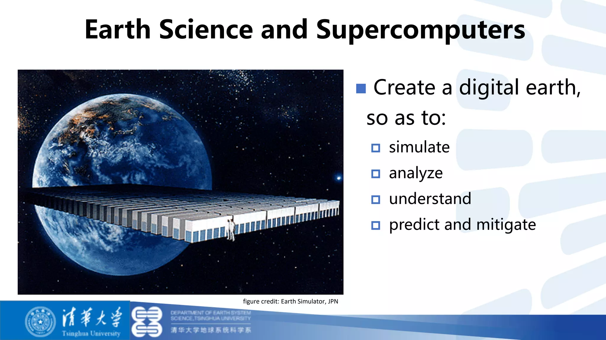
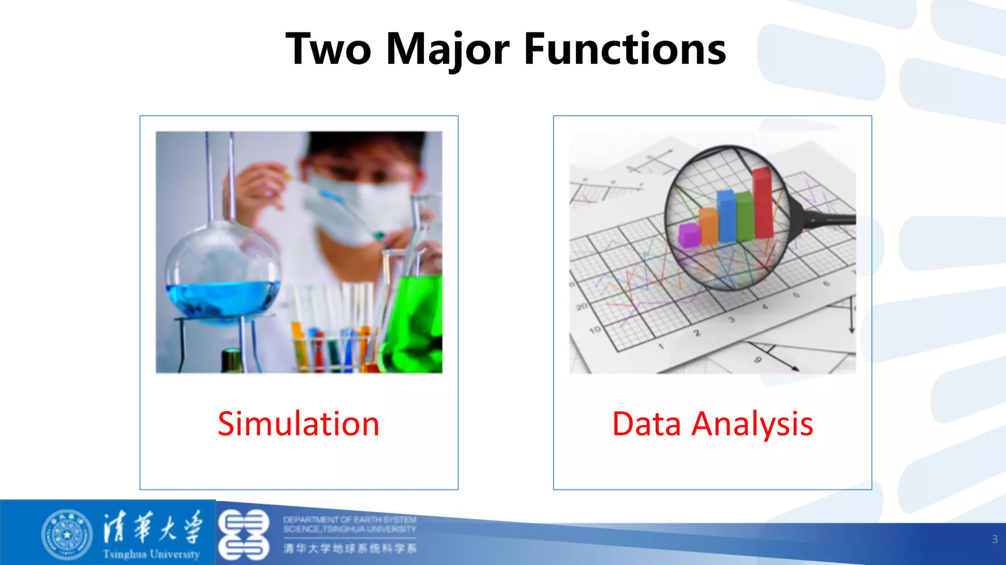
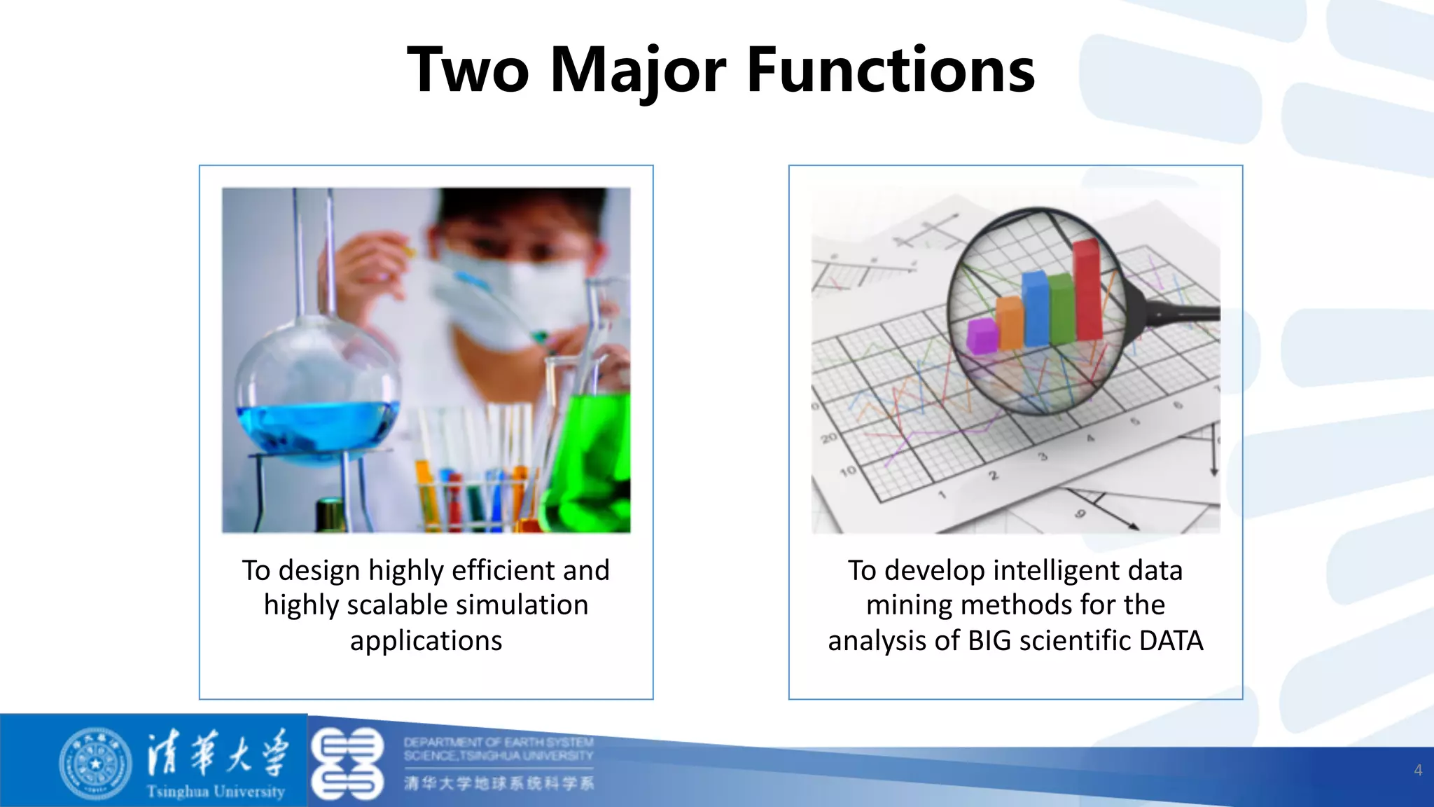
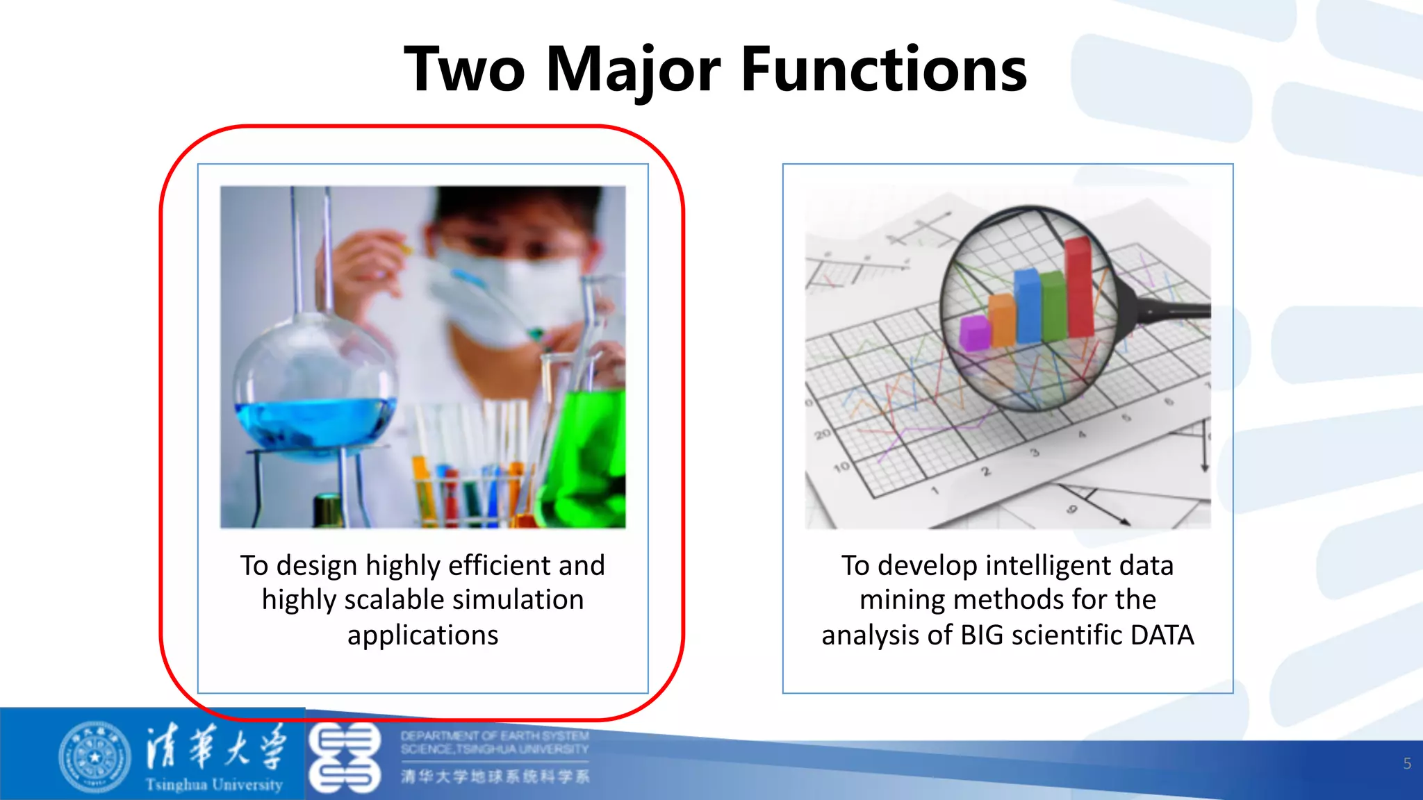
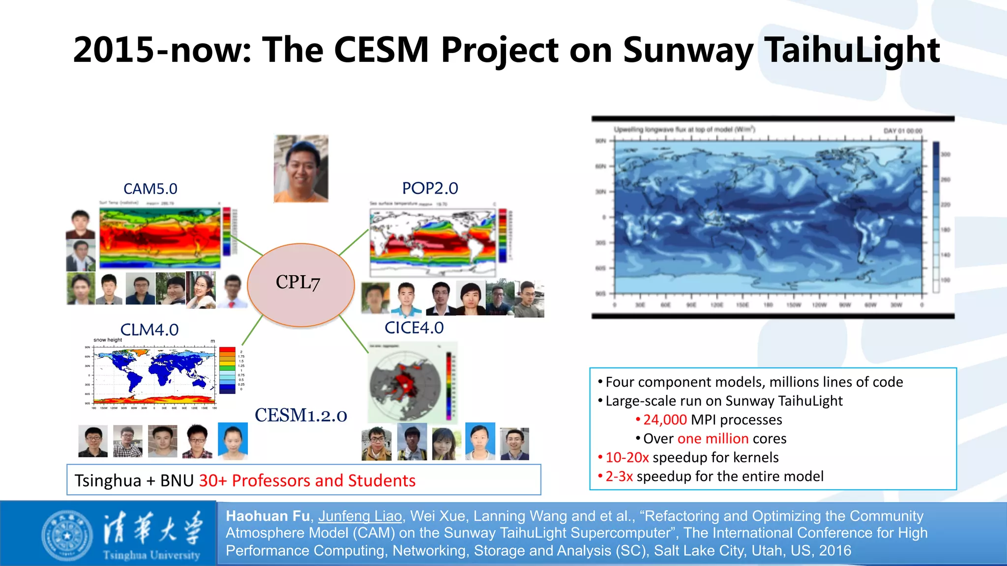
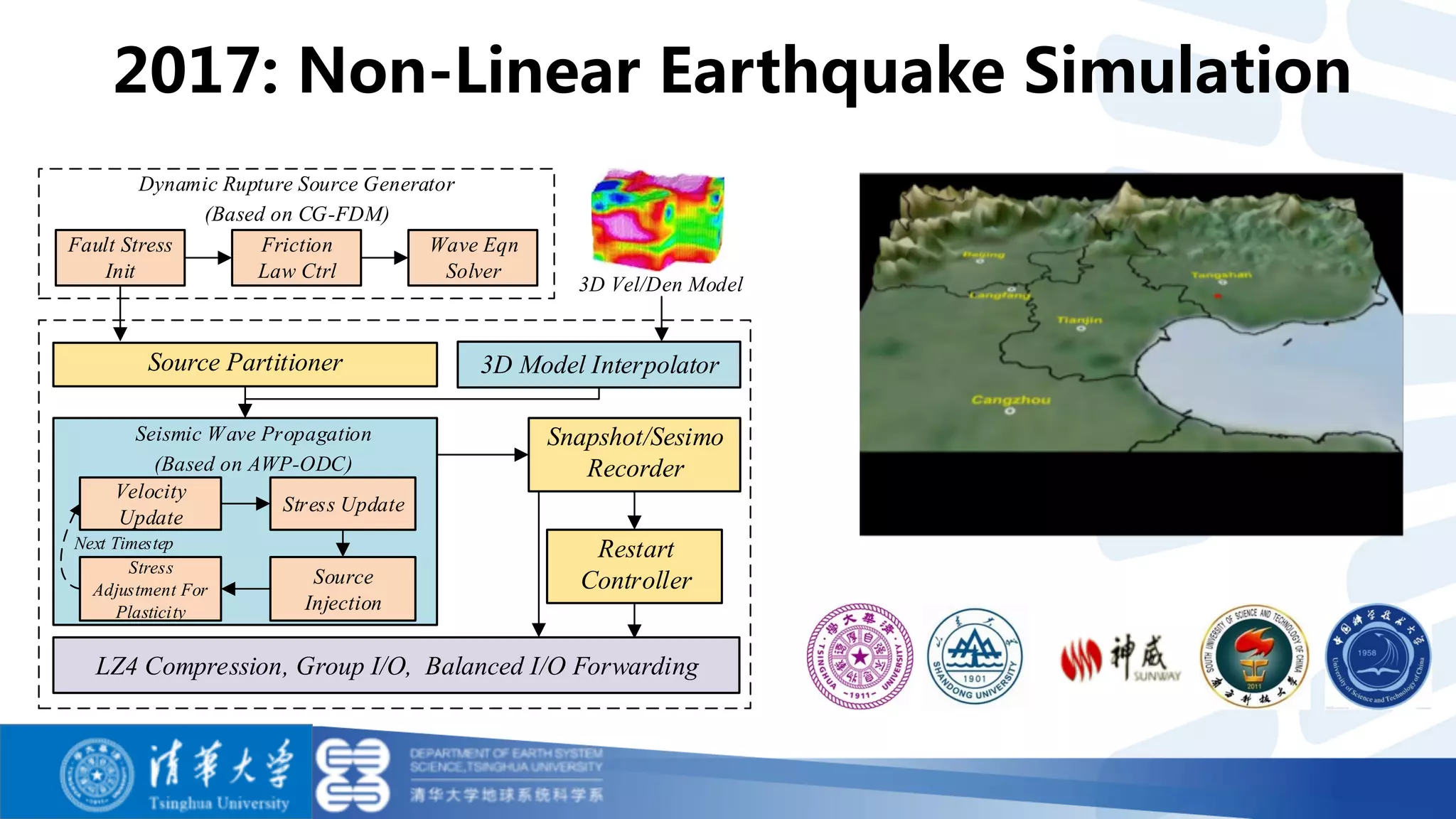
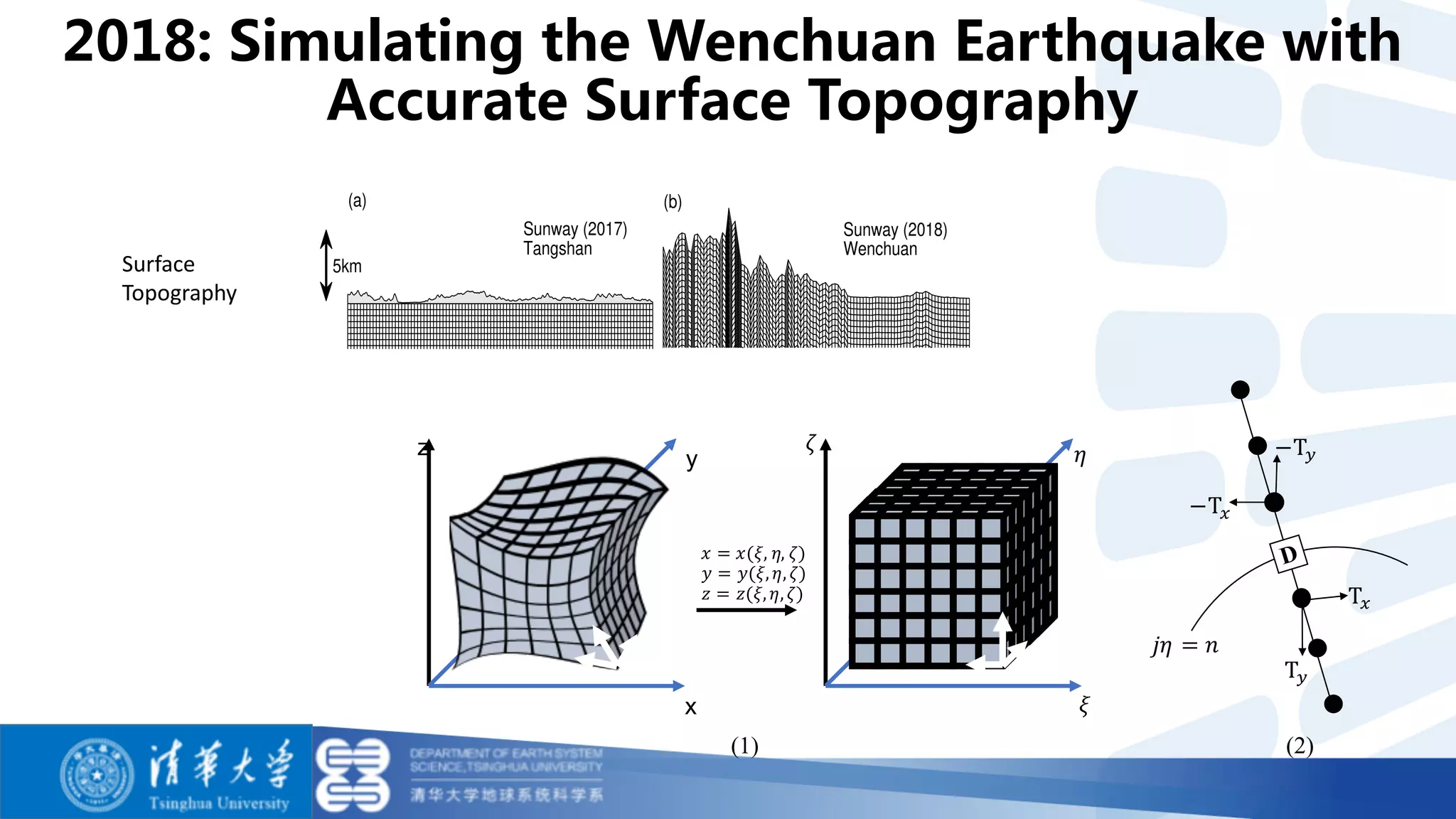
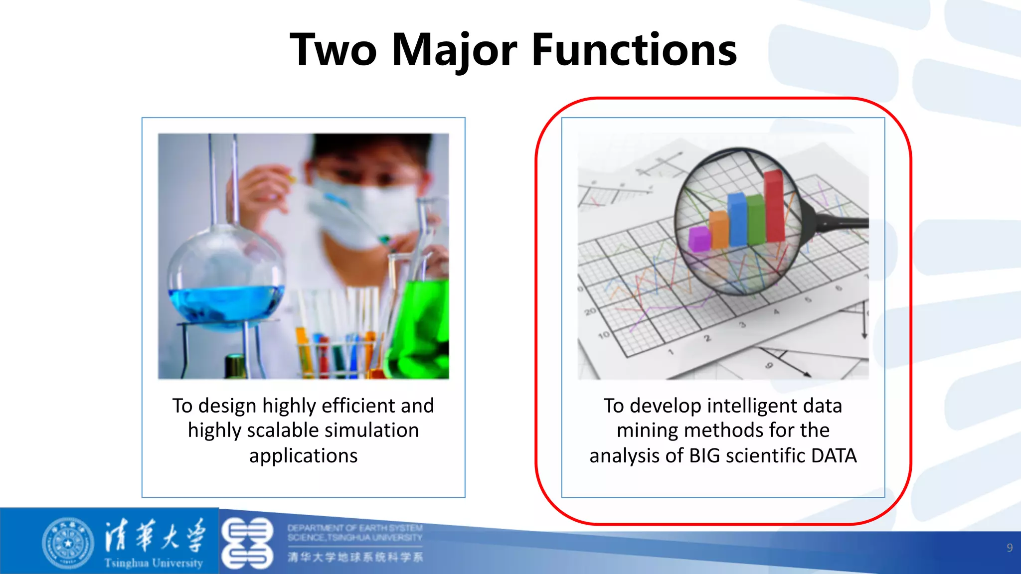
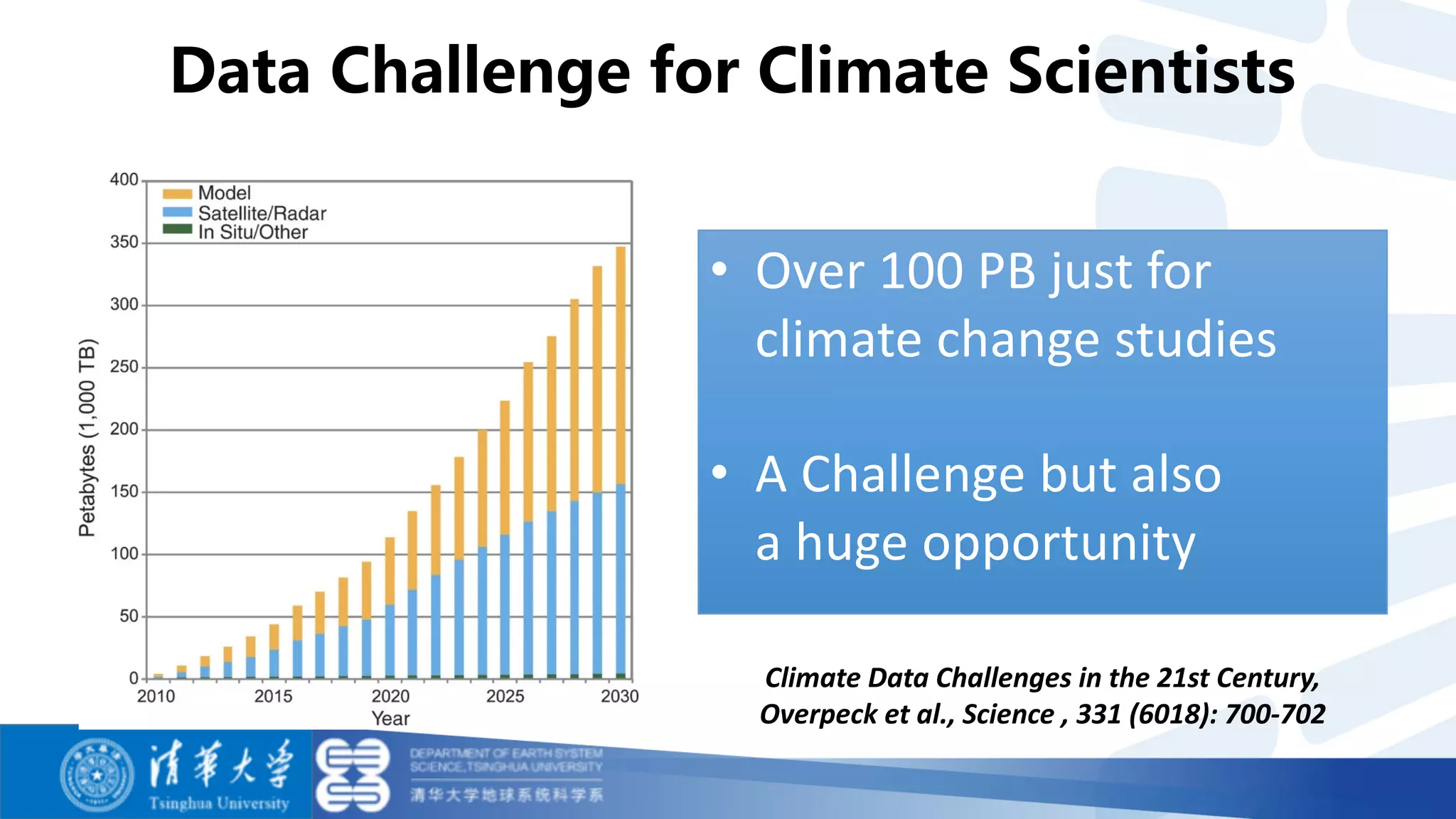
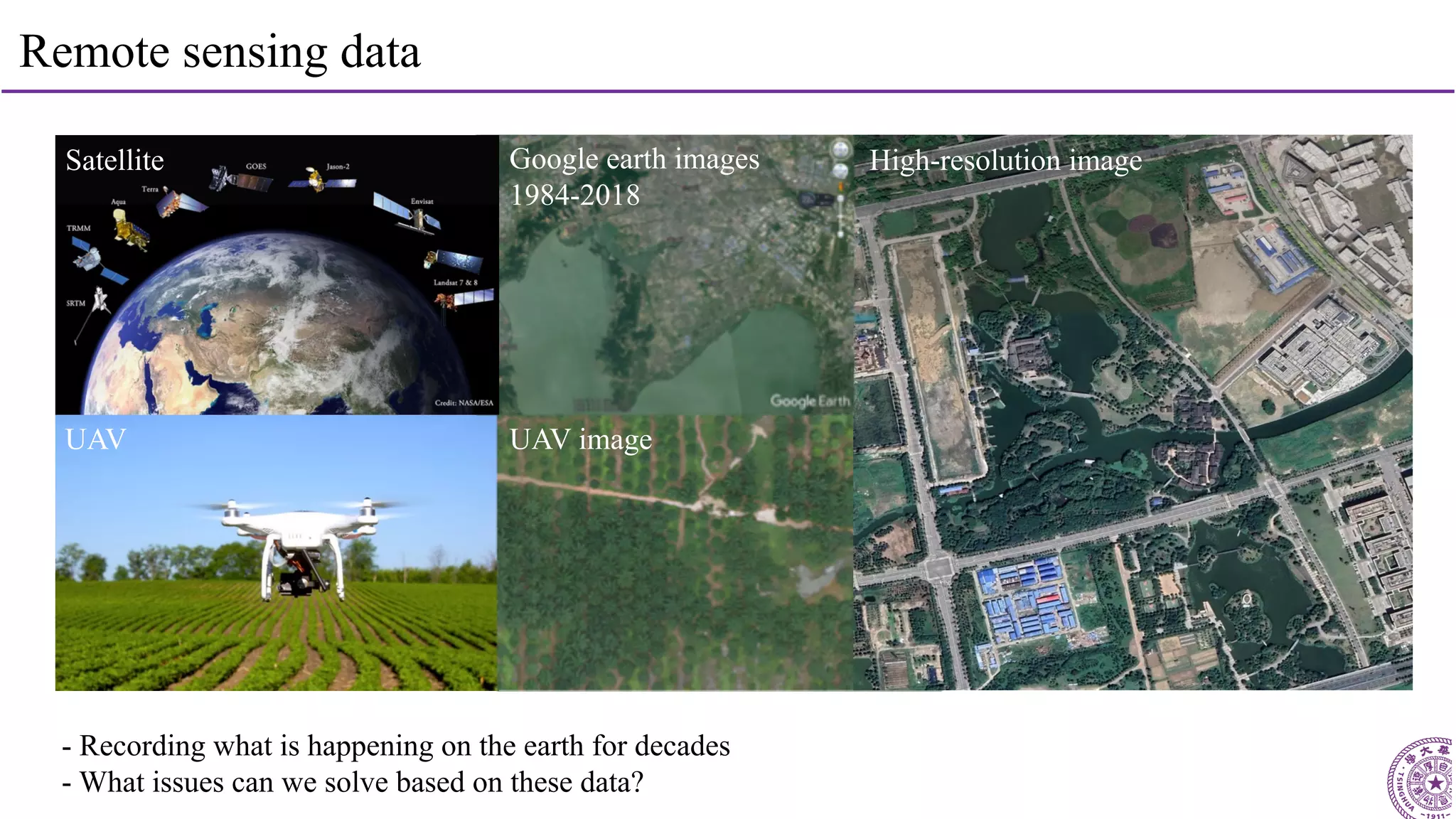
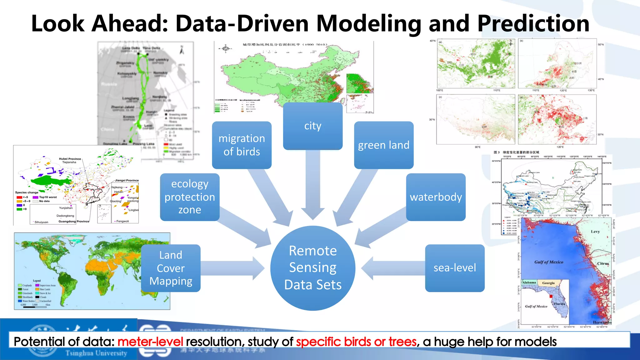
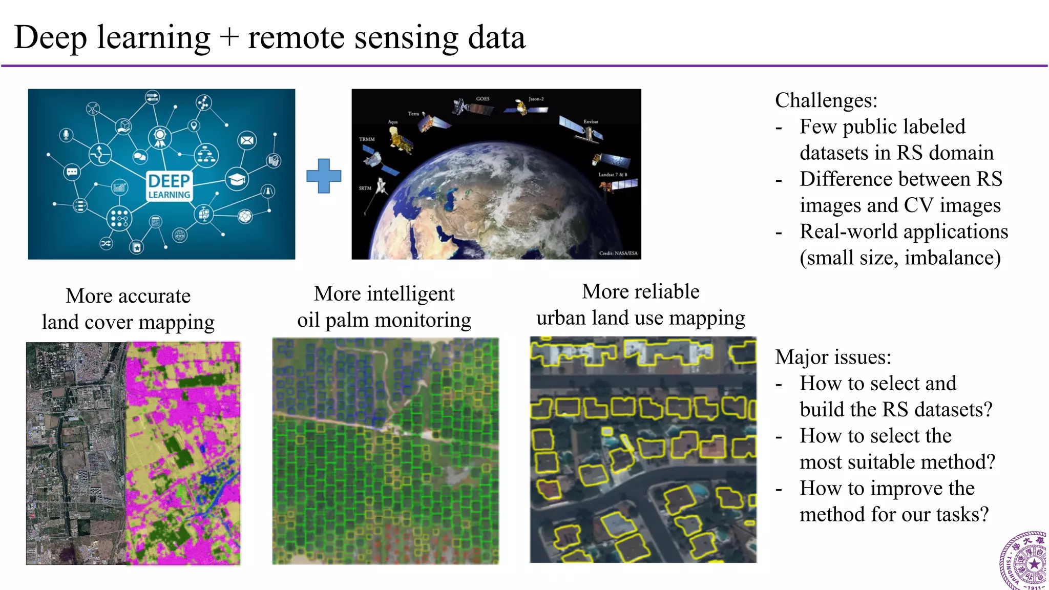
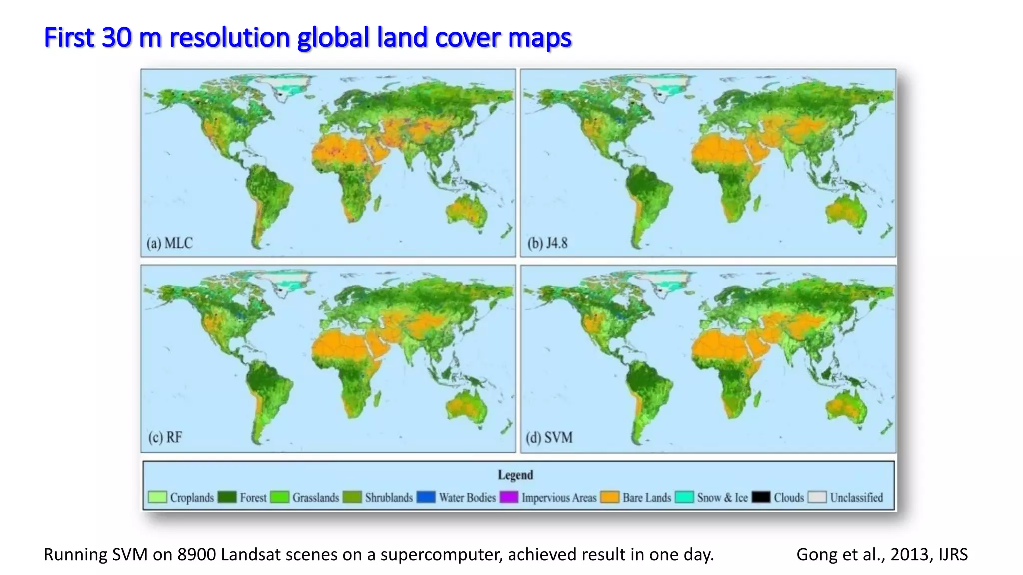
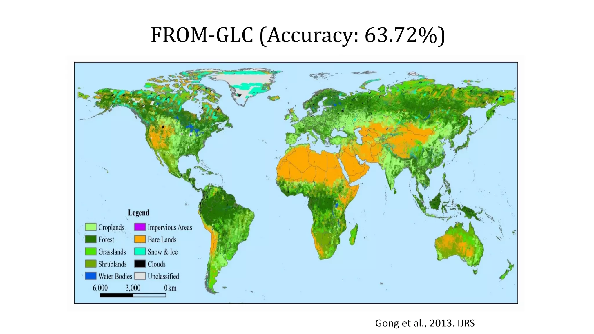
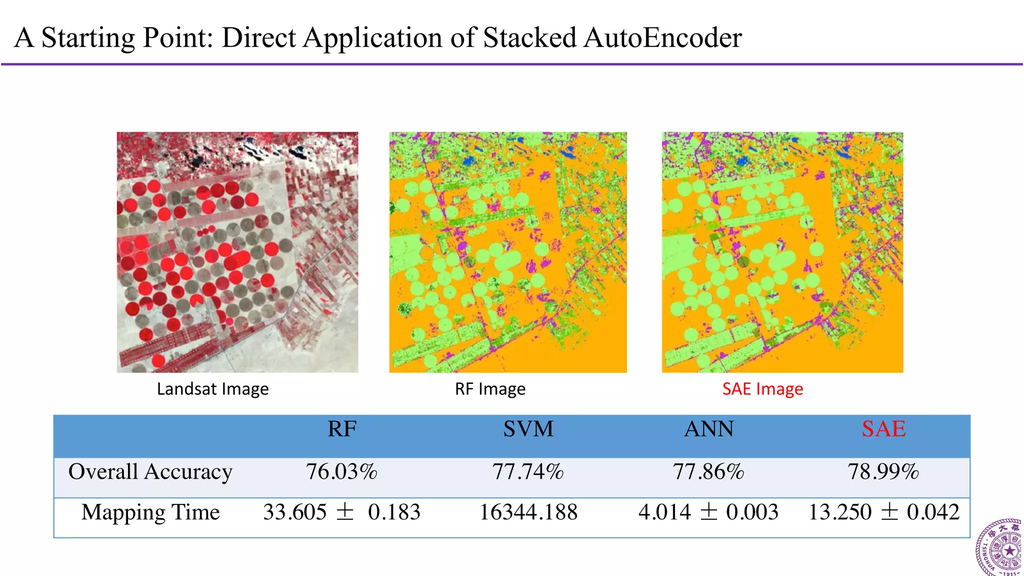
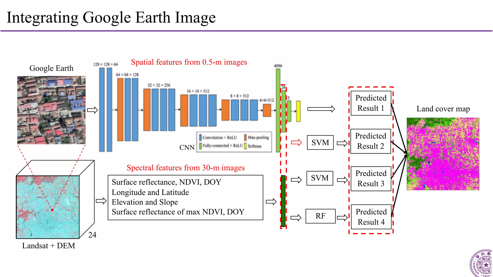
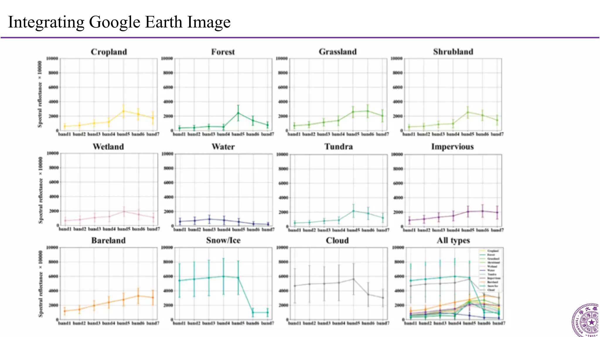
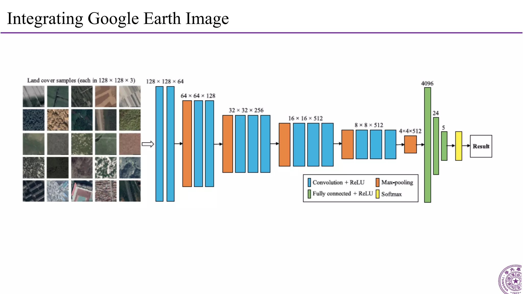
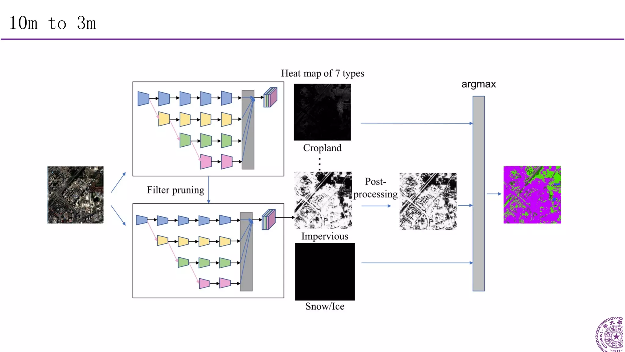
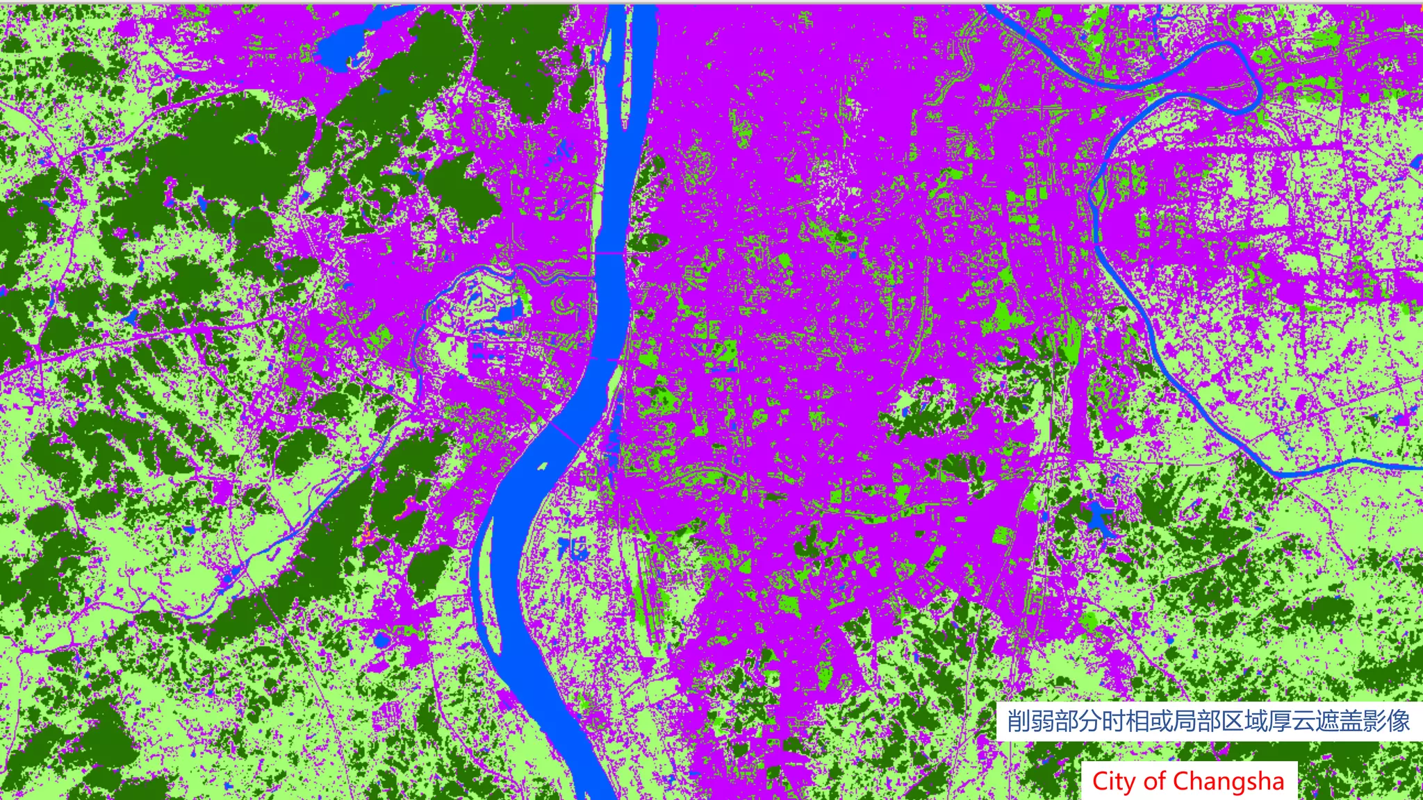
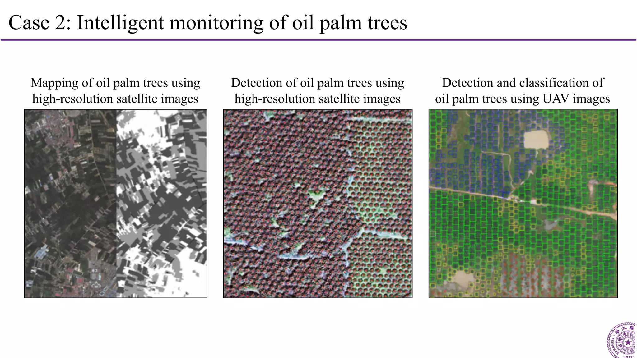
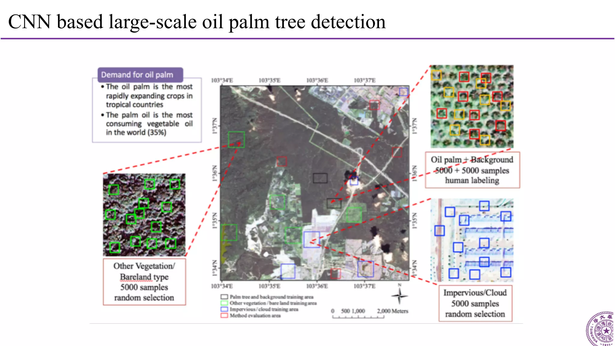
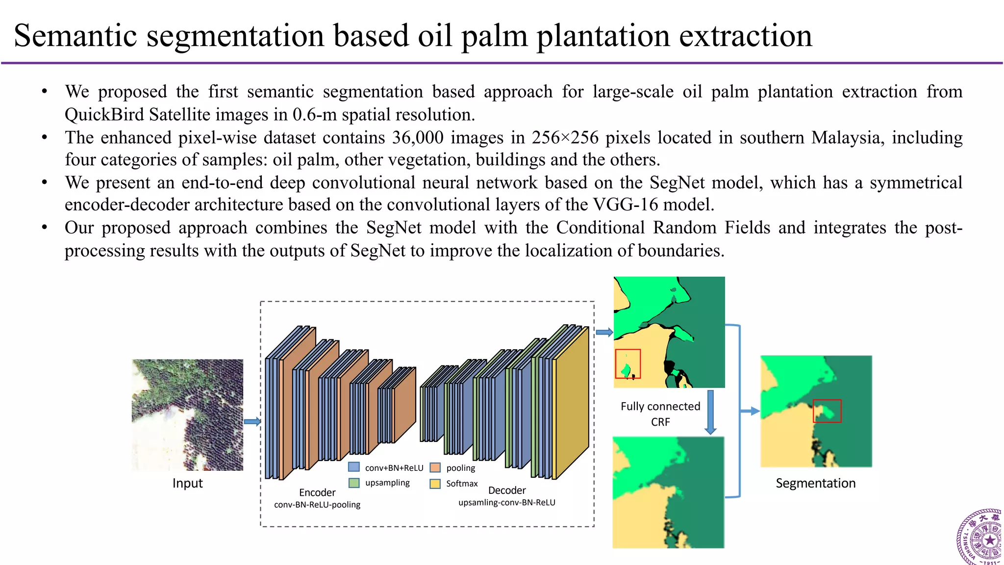
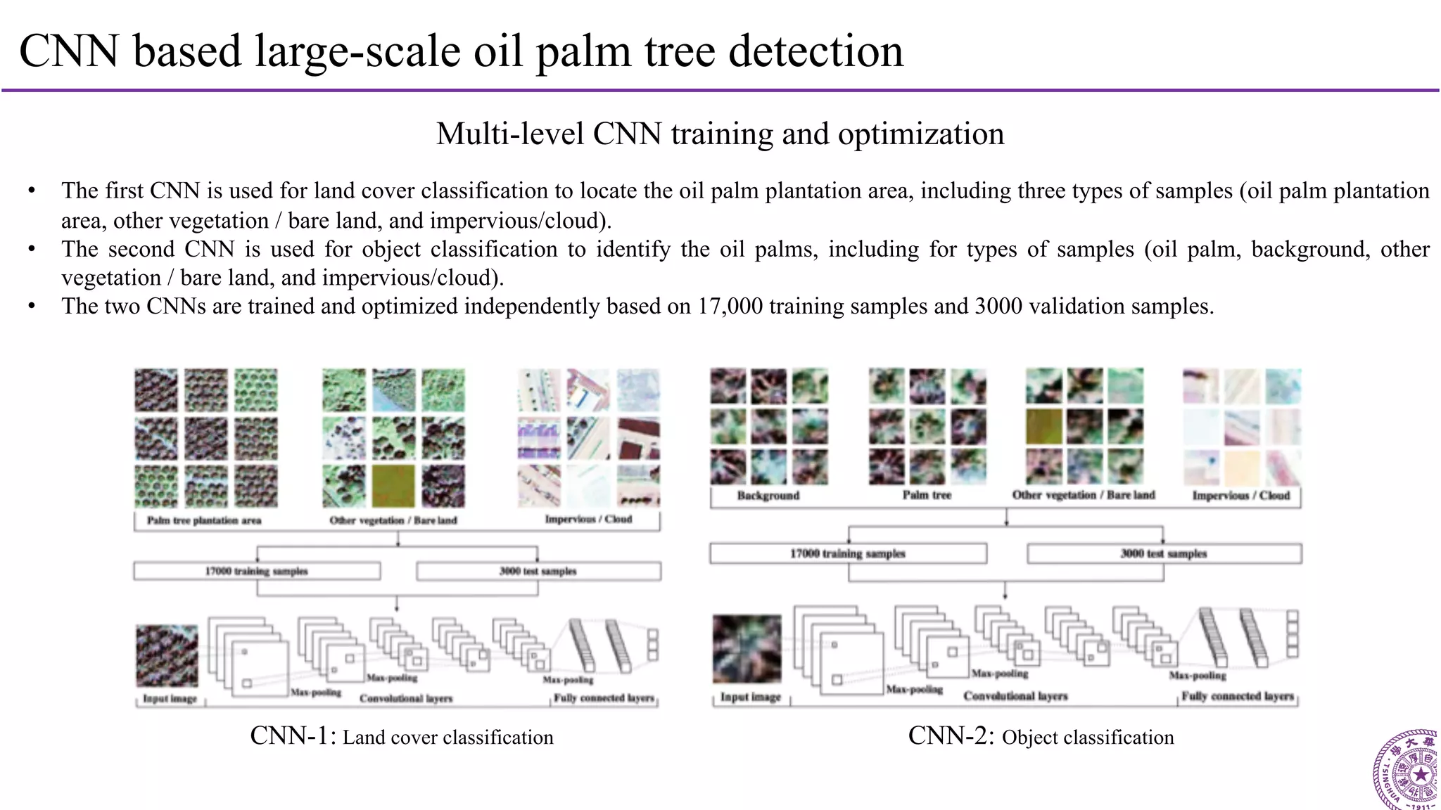
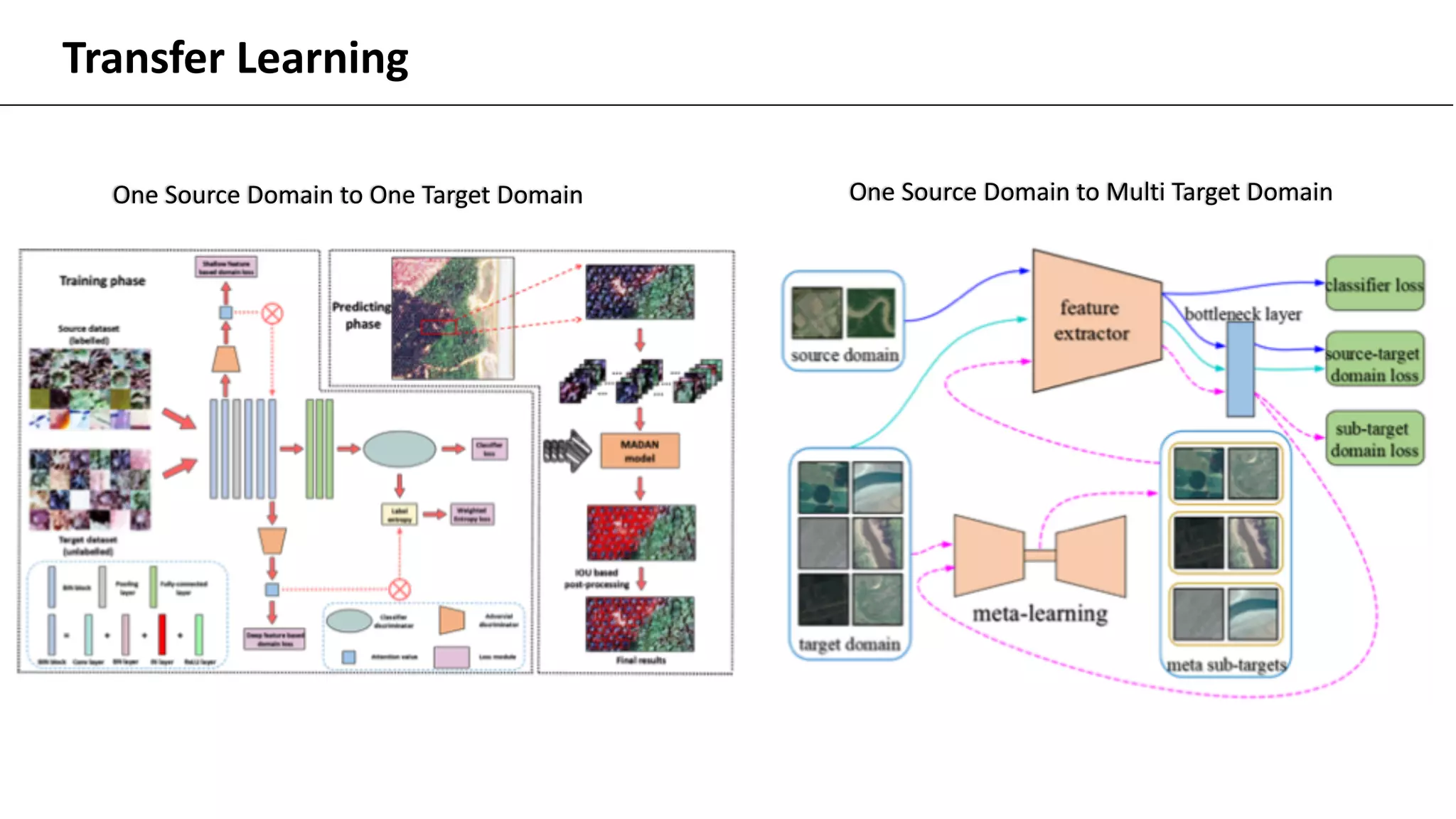
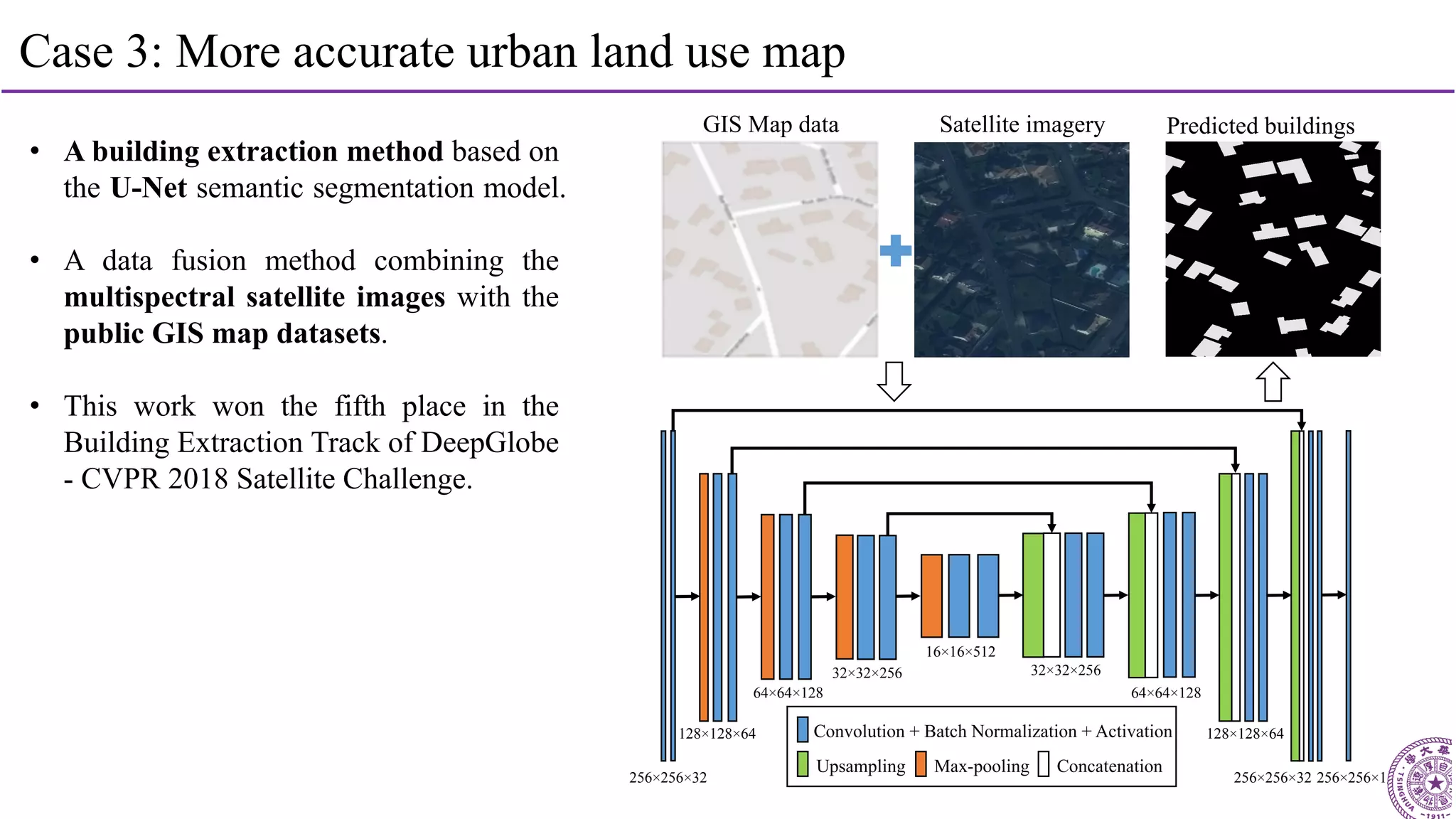
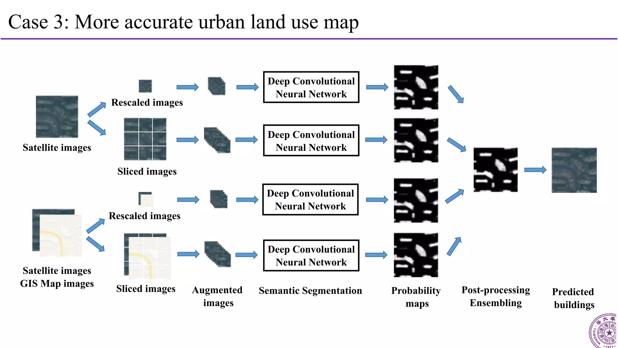
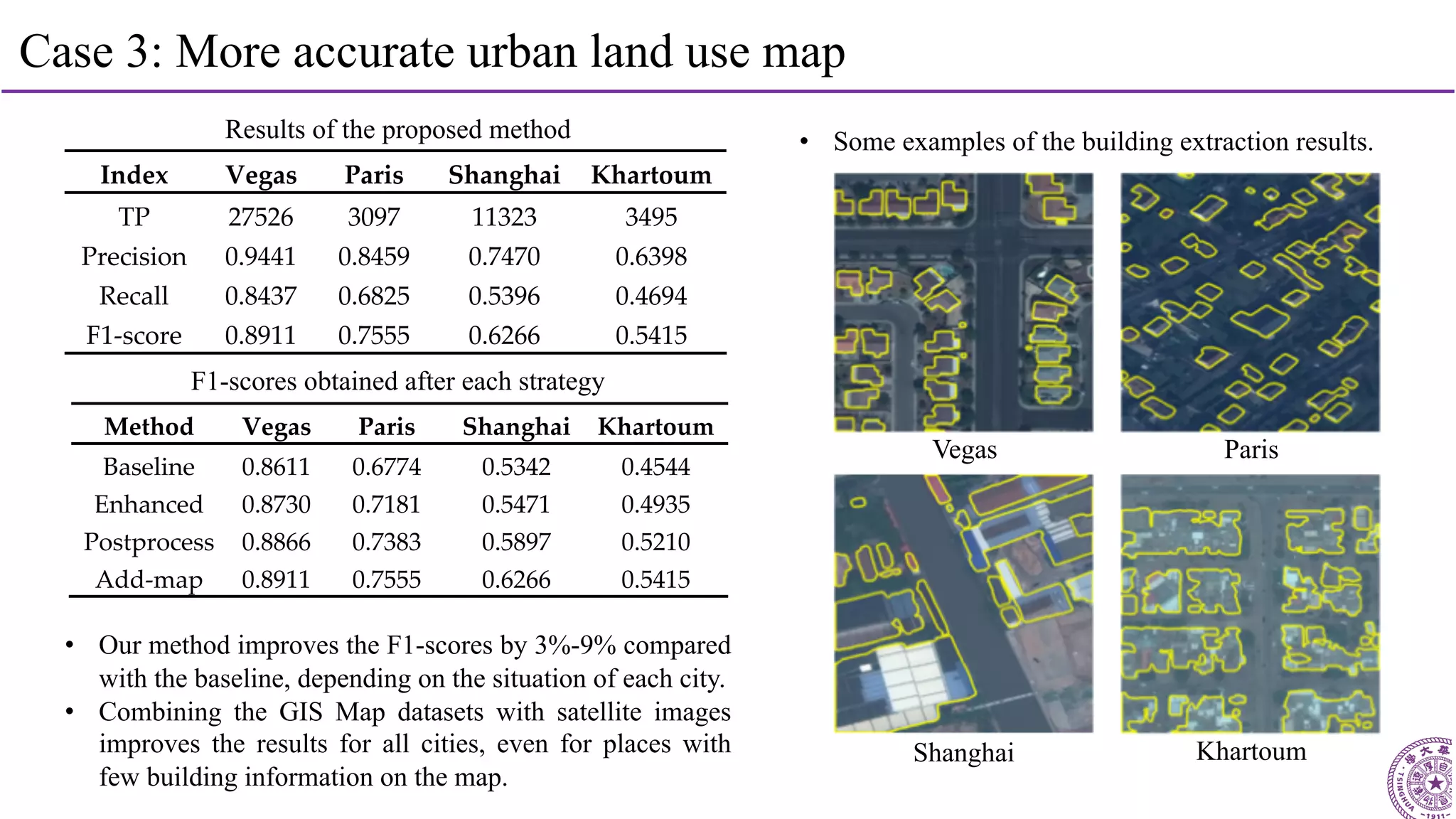
SlideShare a Scribd company logo
SuperAI on Supercomputers
Haohuan Fu
haohuan@tsinghua.edu.cn
High Performance Geo-Computing (HPGC) Group
http://www.thuhpgc.org
n Create a digital earth,
so as to:
p simulate
p analyze
p understand
p predict and mitigate
Earth Science and Supercomputers
figure credit: Earth Simulator, JPN
Simulation Data Analysis
Two Major Functions
3
To design highly efficient and
highly scalable simulation
applications
To develop intelligent data
mining methods for the
analysis of BIG scientific DATA
Two Major Functions
4
To design highly efficient and
highly scalable simulation
applications
To develop intelligent data
mining methods for the
analysis of BIG scientific DATA
Two Major Functions
5
2015-now: The CESM Project on Sunway TaihuLight
6
CAM5.0 POP2.0
CLM4.0 CICE4.0
CPL7
CESM1.2.0
Tsinghua + BNU 30+ Professors and Students
• Four component models, millions lines of code
• Large-scale run on Sunway TaihuLight
• 24,000 MPI processes
• Over one million cores
• 10-20x speedup for kernels
• 2-3x speedup for the entire model
Haohuan Fu, Junfeng Liao, Wei Xue, Lanning Wang and et al., “Refactoring and Optimizing the Community
Atmosphere Model (CAM) on the Sunway TaihuLight Supercomputer”, The International Conference for High
Performance Computing, Networking, Storage and Analysis (SC), Salt Lake City, Utah, US, 2016
2017: Non-Linear Earthquake Simulation
Source Partitioner
Restart
Controller
3D Model Interpolator
LZ4 Compression, Group I/O, Balanced I/O Forwarding
Snapshot/Sesimo
Recorder
Velocity
Update
Stress Update
Source
Injection
Stress
Adjustment For
Plasticity
Dynamic Rupture Source Generator
(Based on CG-FDM)
Seismic Wave Propagation
(Based on AWP-ODC)
Next Timestep
3D Vel/Den Model
Fault Stress
Init
Friction
Law Ctrl
Wave Eqn
Solver
2018: Simulating the Wenchuan Earthquake with
Accurate Surface Topography
Sunway (2017)
Tangshan
(a)
5km
Sunway (2018)
Wenchuan
(b)
Surface
Topography
x
yz
! = !($, &, ')
) = )($, &, ')
* = *($, &, ')
$
&'
(1) (2)
−T-
−T.
T.
T-
/& = 0
To design highly efficient and
highly scalable simulation
applications
To develop intelligent data
mining methods for the
analysis of BIG scientific DATA
Two Major Functions
9
Data Challenge for Climate Scientists
Climate Data Challenges in the 21st Century,
Overpeck et al., Science , 331 (6018): 700-702
• Over 100 PB just for
climate change studies
• A Challenge but also
a huge opportunity
11
Remote sensing data
- Recording what is happening on the earth for decades
- What issues can we solve based on these data?
UAV
Google earth images
1984-2018
UAV image
High-resolution imageSatellite
Look Ahead: Data-Driven Modeling and Prediction
Remote
Sensing
Data Sets
Land
Cover
Mapping
ecology
protection
zone
migration
of birds
city
green land
waterbody
sea-level
13
Cat
Image Classification
Object Detection
Semantic Segmentation
Cat
Grasses
Sky Trees
Deep learning in computer vision
14
More reliable
urban land use mapping
More intelligent
oil palm monitoring
More accurate
land cover mapping
Major issues:
- How to select and
build the RS datasets?
- How to select the
most suitable method?
- How to improve the
method for our tasks?
Challenges:
- Few public labeled
datasets in RS domain
- Difference between RS
images and CV images
- Real-world applications
(small size, imbalance)
Deep learning + remote sensing data
Case 1: More Accurate Land Cover Map
First 30 m resolution global land cover maps
Gong et al., 2013, IJRSRunning SVM on 8900 Landsat scenes on a supercomputer, achieved result in one day.
FROM-GLC	(Accuracy:	63.72%)
Gong et al., 2013. IJRS
18
A Starting Point: Direct Application of Stacked AutoEncoder
RF SVM ANN SAE
Overall Accuracy 76.03% 77.74% 77.86% 78.99%
Mapping Time 33.605 ± 0.183 16344.188 4.014 ± 0.003 13.250 ± 0.042
Landsat Image RF Image SAE Image
19
Integrating Google Earth Image
Surface reflectance, NDVI, DOY
Longitude and Latitude
Elevation and Slope
Surface reflectance of max NDVI, DOY
SVM
Predicted
Result 2
Predicted
Result 1
SVM
Predicted
Result 3
Google Earth
RF
Predicted
Result 4
Spatial features from 0.5-m images
Spectral features from 30-m images
Land cover map
Landsat + DEM
24
CNN
20
Integrating Google Earth Image
21
Integrating Google Earth Image
22
Integrating Google Earth Image
23
Integrating Google Earth Image
Great increase using
Multi-resolution images
Slight increase using
30-meter resolution images
24
Integrating Google Earth Image
Fewer confusions among various land cover types in the results of our proposed method.
Google Earth image Results of RF Results of SVM Results of Ours
Cropland
Forest
Grassland
Shrubland
Water
Impervious
Bare land
Cloud
Legend
25
30m to 10m
Gong P., et al., 2019. Stable classification with limited sample: transferring a 30-m resolution sample set
collected in 2015 to mapping 10-m resolution global land cover in 2017,Science Bulletin.
26
10m to 3m
City of Changsha
削弱部分时相或局部区域厚云遮盖影像
Case 2: Detection of Oil Palm Trees
29
Case 2: Intelligent monitoring of oil palm trees
Detection and classification of
oil palm trees using UAV images
Detection of oil palm trees using
high-resolution satellite images
Mapping of oil palm trees using
high-resolution satellite images
30
CNN based large-scale oil palm tree detection
31
Semantic segmentation based oil palm plantation extraction
• We proposed the first semantic segmentation based approach for large-scale oil palm plantation extraction from
QuickBird Satellite images in 0.6-m spatial resolution.
• The enhanced pixel-wise dataset contains 36,000 images in 256×256 pixels located in southern Malaysia, including
four categories of samples: oil palm, other vegetation, buildings and the others.
• We present an end-to-end deep convolutional neural network based on the SegNet model, which has a symmetrical
encoder-decoder architecture based on the convolutional layers of the VGG-16 model.
• Our proposed approach combines the SegNet model with the Conditional Random Fields and integrates the post-
processing results with the outputs of SegNet to improve the localization of boundaries.
Input
Encoder
conv-BN-ReLU-pooling
Decoder
upsamling-conv-BN-ReLU
conv+BN+ReLU pooling
upsampling Softmax
Fully connected
CRF
Segmentation
32
CNN based large-scale oil palm tree detection
Multi-level CNN training and optimization
• The first CNN is used for land cover classification to locate the oil palm plantation area, including three types of samples (oil palm plantation
area, other vegetation / bare land, and impervious/cloud).
• The second CNN is used for object classification to identify the oil palms, including for types of samples (oil palm, background, other
vegetation / bare land, and impervious/cloud).
• The two CNNs are trained and optimized independently based on 17,000 training samples and 3000 validation samples.
CNN-2: Object classificationCNN-1: Land cover classification
Transfer Learning
One Source Domain to One Target Domain One Source Domain to Multi Target Domain
Case 3: Urban Land Use Map
35
Case 3: More accurate urban land use map
• A building extraction method based on
the U-Net semantic segmentation model.
• A data fusion method combining the
multispectral satellite images with the
public GIS map datasets.
• This work won the fifth place in the
Building Extraction Track of DeepGlobe
- CVPR 2018 Satellite Challenge.
256×256×32
128×128×64
64×64×128
32×32×256 32×32×256
16×16×512
64×64×128
128×128×64
256×256×32
Convolution + Batch Normalization + Activation
Max-poolingUpsampling Concatenation
256×256×1
GIS Map data Satellite imagery Predicted buildings
36
Case 3: More accurate urban land use map
Satellite images
Satellite images
GIS Map images
Rescaled images
Sliced images
Rescaled images
Sliced images Augmented
images
Semantic Segmentation Post-processing
Ensembling
Predicted
buildings
Probability
maps
Deep Convolutional
Neural Network
Deep Convolutional
Neural Network
Deep Convolutional
Neural Network
Deep Convolutional
Neural Network
37
Case 3: More accurate urban land use map
Results of the proposed method
Index Vegas Paris Shanghai Khartoum
TP 27526 3097 11323 3495
Precision 0.9441 0.8459 0.7470 0.6398
Recall 0.8437 0.6825 0.5396 0.4694
F1-score 0.8911 0.7555 0.6266 0.5415
Method Vegas Paris Shanghai Khartoum
Baseline 0.8611 0.6774 0.5342 0.4544
Enhanced 0.8730 0.7181 0.5471 0.4935
Postprocess 0.8866 0.7383 0.5897 0.5210
Add-map 0.8911 0.7555 0.6266 0.5415
• Our method improves the F1-scores by 3%-9% compared
with the baseline, depending on the situation of each city.
• Combining the GIS Map datasets with satellite images
improves the results for all cities, even for places with
few building information on the map.
F1-scores obtained after each strategy
KhartoumShanghai
ParisVegas
• Some examples of the building extraction results.
n Intelligent City Brain:
p Detection
p Understanding
p Modeling
p Planning
AI for City
n Li, Weijia and Dong, Runmin and Fu, Haohuan and Wang, Jie and Yu, Le and Gong, Peng, "Integrating Google Earth imagery with Landsat
data to improve 30-m resolution land cover mapping", Remote Sensing of Environment, vol. 237, pp. 111563, 2020.
n Zheng, Juepeng and Li, Weijia and Xia, Maocai and Dong, Runmin and Fu, Haohuan and Yuan, Shuai, "Large-Scale Oil Palm Tree Detection
from High-Resolution Remote Sensing Images Using Faster-RCNN", Proc. IEEE International Geoscience and Remote Sensing Symposium
(IGARSS), pp. 1422-1425, 2019.
n Dong, Runmin and Li, Weijia and Fu, Haohuan and Gan, Lin and Yu, Le and Zheng, Juepeng and Xia, Maocai, "Oil palm plantation mapping
from high-resolution remote sensing images using deep learning", to appear in International Journal of Remote Sensing, pp. 1-25, 2019.
n Xia, Maocai and Li, Weijia and Fu, Haohuan and Yu, Le and Dong, Runmin and Zheng, Juepeng, "Fast and robust detection of oil palm trees
using high-resolution remote sensing images", Proc. Automatic Target Recognition XXIX, vol. 10988, pp. 109880C, 2019.
n Dong, Runmin and Li, Weijia and Fu, Haohuan and Xia, Maocai and Zheng, Juepeng and Yu, Le, "Semantic segmentation based large-scale
oil palm plantation detection using high-resolution satellite images", Proc. Automatic Target Recognition XXIX, vol. 10988, pp. 109880D,
2019.
n Li, Weijia and He, Conghui and Fu, Haohuan and Zheng, Juepeng and Dong, Runmin and Xia, Maocai and Yu, Le and Luk, Wayne, "A Real-
Time Tree Crown Detection Approach for Large-Scale Remote Sensing Images on FPGAs", Remote Sensing, vol. 11, no. 9, pp. 1025, 2019.
n Gong, Peng and Liu, Han and Zhang, Meinan and Li, Congcong and Wang, Jie and Huang, Huabing and Clinton, Nicholas and Ji, Luyan and
Li, Wenyu and Bai, Yuqi and others, "Stable classification with limited sample: transferring a 30-m resolution sample set collected in 2015 to
mapping 10-m resolution global land cover in 2017", Science Bulletin, vol. 64, no. 6, pp. 370-373, 2019.
n Li, Weijia and He, Conghui and Fang, Jiarui and Zheng, Juepeng and Fu, Haohuan and Yu, Le, "Semantic Segmentation-Based Building
Footprint Extraction Using Very High-Resolution Satellite Images and Multi-Source GIS Data", Remote Sensing, vol. 11, no. 4, pp. 403, 2019.
n Li, Weijia and Dong, Runmin and Fu, Haohuan and Yu, Le, “Large-scale oil palm tree detection from high-resolution satellite images using
two-stage convolutional neural networks”, Remote Sensing, vol. 11, no. 1, pp. 11, 2019.

More Related Content

What's hot

Active learning algorithms in seismic facies classification
Active learning algorithms in seismic facies classificationActive learning algorithms in seismic facies classification
Active learning algorithms in seismic facies classification
Pioneer Natural Resources
 
MACHINE LEARNING FOR SATELLITE-GUIDED WATER QUALITY MONITORING
MACHINE LEARNING FOR SATELLITE-GUIDED WATER QUALITY MONITORINGMACHINE LEARNING FOR SATELLITE-GUIDED WATER QUALITY MONITORING
MACHINE LEARNING FOR SATELLITE-GUIDED WATER QUALITY MONITORING
VisionGEOMATIQUE2014
 
2 1 xie_solar_2016_pv_systems
2 1 xie_solar_2016_pv_systems2 1 xie_solar_2016_pv_systems
IRJET- Land Cover Index Classification using Satellite Images with Different ...
IRJET- Land Cover Index Classification using Satellite Images with Different ...IRJET- Land Cover Index Classification using Satellite Images with Different ...
IRJET- Land Cover Index Classification using Satellite Images with Different ...
IRJET Journal
 
Harmonization of seismic hazard assessment: the SHARE example
Harmonization of seismic hazard assessment: the SHARE exampleHarmonization of seismic hazard assessment: the SHARE example
Harmonization of seismic hazard assessment: the SHARE example
Global Risk Forum GRFDavos
 
Soluzioni space-based per la sostenibilità
Soluzioni space-based per la sostenibilitàSoluzioni space-based per la sostenibilità
Soluzioni space-based per la sostenibilità
MariaBrovelli1
 
Cnn acuracia remotesensing-08-00329
Cnn acuracia remotesensing-08-00329Cnn acuracia remotesensing-08-00329
Cnn acuracia remotesensing-08-00329
Universidade Fumec
 
Visualizing 3D atmospheric data with spherical volume texture on virtual globes
Visualizing 3D atmospheric data with spherical volume texture on virtual globesVisualizing 3D atmospheric data with spherical volume texture on virtual globes
Visualizing 3D atmospheric data with spherical volume texture on virtual globes
Jianming Liang
 
CLIM: Transition Workshop - Optimization Methods in Remote Sensing - Jessica...
CLIM: Transition Workshop - Optimization Methods in Remote Sensing  - Jessica...CLIM: Transition Workshop - Optimization Methods in Remote Sensing  - Jessica...
CLIM: Transition Workshop - Optimization Methods in Remote Sensing - Jessica...
The Statistical and Applied Mathematical Sciences Institute
 
Future guidelines the meteorological view - Isabel Martínez (AEMet)
Future guidelines the meteorological view - Isabel Martínez (AEMet)Future guidelines the meteorological view - Isabel Martínez (AEMet)
Future guidelines the meteorological view - Isabel Martínez (AEMet)
IrSOLaV Pomares
 
A comparison of classification techniques for seismic facies recognition
A comparison of classification techniques for seismic facies recognitionA comparison of classification techniques for seismic facies recognition
A comparison of classification techniques for seismic facies recognition
Pioneer Natural Resources
 
Food Security Use Case - ExtremeEarth Open Workshop
Food Security Use Case - ExtremeEarth Open WorkshopFood Security Use Case - ExtremeEarth Open Workshop
Food Security Use Case - ExtremeEarth Open Workshop
ExtremeEarth
 
Accès ouvert aux données météorologiques d’Environnement Canada
Accès ouvert aux données météorologiques d’Environnement CanadaAccès ouvert aux données météorologiques d’Environnement Canada
Accès ouvert aux données météorologiques d’Environnement Canada
VisionGEOMATIQUE2014
 
IRJET- Geological Boundary Detection for Satellite Images using AI Technique
IRJET- Geological Boundary Detection for Satellite Images using AI TechniqueIRJET- Geological Boundary Detection for Satellite Images using AI Technique
IRJET- Geological Boundary Detection for Satellite Images using AI Technique
IRJET Journal
 
The UAE solar Atlas
The UAE solar AtlasThe UAE solar Atlas
The UAE solar Atlas
IRENA Global Atlas
 
Processing of raw astronomical data of large volume by map reduce model
Processing of raw astronomical data of large volume by map reduce modelProcessing of raw astronomical data of large volume by map reduce model
Processing of raw astronomical data of large volume by map reduce model
Sergey Gerasimov
 
20110723IGARSS_ZHAO-yang.ppt
20110723IGARSS_ZHAO-yang.ppt20110723IGARSS_ZHAO-yang.ppt
20110723IGARSS_ZHAO-yang.ppt
grssieee
 
CLIM Program: Remote Sensing Workshop, Optimization Methods in Remote Sensing...
CLIM Program: Remote Sensing Workshop, Optimization Methods in Remote Sensing...CLIM Program: Remote Sensing Workshop, Optimization Methods in Remote Sensing...
CLIM Program: Remote Sensing Workshop, Optimization Methods in Remote Sensing...
The Statistical and Applied Mathematical Sciences Institute
 
Short-term solar forecasting based on sky images
Short-term solar forecasting based on sky imagesShort-term solar forecasting based on sky images
Short-term solar forecasting based on sky images
Sandia National Laboratories: Energy & Climate: Renewables
 
Verso le trusted smart statistics - prospettive di sviluppo e risultati del e...
Verso le trusted smart statistics - prospettive di sviluppo e risultati del e...Verso le trusted smart statistics - prospettive di sviluppo e risultati del e...
Verso le trusted smart statistics - prospettive di sviluppo e risultati del e...
Istituto nazionale di statistica
 

What's hot (20)

Active learning algorithms in seismic facies classification
Active learning algorithms in seismic facies classificationActive learning algorithms in seismic facies classification
Active learning algorithms in seismic facies classification
 
MACHINE LEARNING FOR SATELLITE-GUIDED WATER QUALITY MONITORING
MACHINE LEARNING FOR SATELLITE-GUIDED WATER QUALITY MONITORINGMACHINE LEARNING FOR SATELLITE-GUIDED WATER QUALITY MONITORING
MACHINE LEARNING FOR SATELLITE-GUIDED WATER QUALITY MONITORING
 
2 1 xie_solar_2016_pv_systems
2 1 xie_solar_2016_pv_systems2 1 xie_solar_2016_pv_systems
2 1 xie_solar_2016_pv_systems
 
IRJET- Land Cover Index Classification using Satellite Images with Different ...
IRJET- Land Cover Index Classification using Satellite Images with Different ...IRJET- Land Cover Index Classification using Satellite Images with Different ...
IRJET- Land Cover Index Classification using Satellite Images with Different ...
 
Harmonization of seismic hazard assessment: the SHARE example
Harmonization of seismic hazard assessment: the SHARE exampleHarmonization of seismic hazard assessment: the SHARE example
Harmonization of seismic hazard assessment: the SHARE example
 
Soluzioni space-based per la sostenibilità
Soluzioni space-based per la sostenibilitàSoluzioni space-based per la sostenibilità
Soluzioni space-based per la sostenibilità
 
Cnn acuracia remotesensing-08-00329
Cnn acuracia remotesensing-08-00329Cnn acuracia remotesensing-08-00329
Cnn acuracia remotesensing-08-00329
 
Visualizing 3D atmospheric data with spherical volume texture on virtual globes
Visualizing 3D atmospheric data with spherical volume texture on virtual globesVisualizing 3D atmospheric data with spherical volume texture on virtual globes
Visualizing 3D atmospheric data with spherical volume texture on virtual globes
 
CLIM: Transition Workshop - Optimization Methods in Remote Sensing - Jessica...
CLIM: Transition Workshop - Optimization Methods in Remote Sensing  - Jessica...CLIM: Transition Workshop - Optimization Methods in Remote Sensing  - Jessica...
CLIM: Transition Workshop - Optimization Methods in Remote Sensing - Jessica...
 
Future guidelines the meteorological view - Isabel Martínez (AEMet)
Future guidelines the meteorological view - Isabel Martínez (AEMet)Future guidelines the meteorological view - Isabel Martínez (AEMet)
Future guidelines the meteorological view - Isabel Martínez (AEMet)
 
A comparison of classification techniques for seismic facies recognition
A comparison of classification techniques for seismic facies recognitionA comparison of classification techniques for seismic facies recognition
A comparison of classification techniques for seismic facies recognition
 
Food Security Use Case - ExtremeEarth Open Workshop
Food Security Use Case - ExtremeEarth Open WorkshopFood Security Use Case - ExtremeEarth Open Workshop
Food Security Use Case - ExtremeEarth Open Workshop
 
Accès ouvert aux données météorologiques d’Environnement Canada
Accès ouvert aux données météorologiques d’Environnement CanadaAccès ouvert aux données météorologiques d’Environnement Canada
Accès ouvert aux données météorologiques d’Environnement Canada
 
IRJET- Geological Boundary Detection for Satellite Images using AI Technique
IRJET- Geological Boundary Detection for Satellite Images using AI TechniqueIRJET- Geological Boundary Detection for Satellite Images using AI Technique
IRJET- Geological Boundary Detection for Satellite Images using AI Technique
 
The UAE solar Atlas
The UAE solar AtlasThe UAE solar Atlas
The UAE solar Atlas
 
Processing of raw astronomical data of large volume by map reduce model
Processing of raw astronomical data of large volume by map reduce modelProcessing of raw astronomical data of large volume by map reduce model
Processing of raw astronomical data of large volume by map reduce model
 
20110723IGARSS_ZHAO-yang.ppt
20110723IGARSS_ZHAO-yang.ppt20110723IGARSS_ZHAO-yang.ppt
20110723IGARSS_ZHAO-yang.ppt
 
CLIM Program: Remote Sensing Workshop, Optimization Methods in Remote Sensing...
CLIM Program: Remote Sensing Workshop, Optimization Methods in Remote Sensing...CLIM Program: Remote Sensing Workshop, Optimization Methods in Remote Sensing...
CLIM Program: Remote Sensing Workshop, Optimization Methods in Remote Sensing...
 
Short-term solar forecasting based on sky images
Short-term solar forecasting based on sky imagesShort-term solar forecasting based on sky images
Short-term solar forecasting based on sky images
 
Verso le trusted smart statistics - prospettive di sviluppo e risultati del e...
Verso le trusted smart statistics - prospettive di sviluppo e risultati del e...Verso le trusted smart statistics - prospettive di sviluppo e risultati del e...
Verso le trusted smart statistics - prospettive di sviluppo e risultati del e...
 

Similar to 12 SuperAI on Supercomputers

Final thesis presentation
Final thesis presentationFinal thesis presentation
Final thesis presentation
Pawan Singh
 
Ijetcas14 474
Ijetcas14 474Ijetcas14 474
Ijetcas14 474
Iasir Journals
 
[DSC Europe 22] Land Boundary Delineation using U-net - Theophilus Aidoo
[DSC Europe 22] Land Boundary Delineation using U-net - Theophilus Aidoo[DSC Europe 22] Land Boundary Delineation using U-net - Theophilus Aidoo
[DSC Europe 22] Land Boundary Delineation using U-net - Theophilus Aidoo
DataScienceConferenc1
 
SmartGeo - G. Satta
SmartGeo - G. SattaSmartGeo - G. Satta
SmartGeo - G. Satta
Sardegna Ricerche
 
Machine learning for decentralized and flying radio devices
Machine learning for decentralized and flying radio devicesMachine learning for decentralized and flying radio devices
Machine learning for decentralized and flying radio devices
ITU
 
Unveiling deforestation patterns using satellite imagery.pptx
Unveiling deforestation patterns using satellite imagery.pptxUnveiling deforestation patterns using satellite imagery.pptx
Unveiling deforestation patterns using satellite imagery.pptx
1am20ai011amceducati
 
A Review Of Different Approaches Of Land Cover Mapping
A Review Of Different Approaches Of Land Cover MappingA Review Of Different Approaches Of Land Cover Mapping
A Review Of Different Approaches Of Land Cover Mapping
Jose Katab
 
Performance evaluation of transfer learning based deep convolutional neural n...
Performance evaluation of transfer learning based deep convolutional neural n...Performance evaluation of transfer learning based deep convolutional neural n...
Performance evaluation of transfer learning based deep convolutional neural n...
IJECEIAES
 
CrowdMap: Accurate Reconstruction of Indoor Floor Plan from Crowdsourced Sens...
CrowdMap: Accurate Reconstruction of Indoor Floor Plan from Crowdsourced Sens...CrowdMap: Accurate Reconstruction of Indoor Floor Plan from Crowdsourced Sens...
CrowdMap: Accurate Reconstruction of Indoor Floor Plan from Crowdsourced Sens...
Si Chen
 
Drones and A.I in Earth Science
Drones and A.I in Earth ScienceDrones and A.I in Earth Science
Drones and A.I in Earth Science
ARDC
 
SDSC Technology Forum: Increasing the Impact of High Resolution Topography Da...
SDSC Technology Forum: Increasing the Impact of High Resolution Topography Da...SDSC Technology Forum: Increasing the Impact of High Resolution Topography Da...
SDSC Technology Forum: Increasing the Impact of High Resolution Topography Da...
OpenTopography Facility
 
IRJET- Land Use & Land Cover Change Detection using G.I.S. & Remote Sensing
IRJET-  	  Land Use & Land Cover Change Detection using G.I.S. & Remote SensingIRJET-  	  Land Use & Land Cover Change Detection using G.I.S. & Remote Sensing
IRJET- Land Use & Land Cover Change Detection using G.I.S. & Remote Sensing
IRJET Journal
 
land health surveillance highlights
land health surveillance highlightsland health surveillance highlights
land health surveillance highlights
World Agroforestry (ICRAF)
 
Using Pleiades Very High Resolution Images for planning activities in feasib...
Using Pleiades  Very High Resolution Images for planning activities in feasib...Using Pleiades  Very High Resolution Images for planning activities in feasib...
Using Pleiades Very High Resolution Images for planning activities in feasib...
Argongra Gis
 
MapInfo Discover 3D for Wind Energy Resources
MapInfo Discover 3D for Wind Energy ResourcesMapInfo Discover 3D for Wind Energy Resources
MapInfo Discover 3D for Wind Energy Resources
Prakher Hajela Saxena
 
Unsupervised Building Extraction from High Resolution Satellite Images Irresp...
Unsupervised Building Extraction from High Resolution Satellite Images Irresp...Unsupervised Building Extraction from High Resolution Satellite Images Irresp...
Unsupervised Building Extraction from High Resolution Satellite Images Irresp...
CSCJournals
 
Advertisement billboard detection and geotagging system with inductive transf...
Advertisement billboard detection and geotagging system with inductive transf...Advertisement billboard detection and geotagging system with inductive transf...
Advertisement billboard detection and geotagging system with inductive transf...
TELKOMNIKA JOURNAL
 
3D GPR in Archaeology What can be gained fron Dense Data
3D GPR in Archaeology What can be gained fron Dense Data3D GPR in Archaeology What can be gained fron Dense Data
3D GPR in Archaeology What can be gained fron Dense Data
Alex Novo
 
MAXSS & NVIDIA
MAXSS & NVIDIAMAXSS & NVIDIA
MAXSS & NVIDIA
Alison B. Lowndes
 
Automated change detection in grass gis
Automated change detection in grass gisAutomated change detection in grass gis
Automated change detection in grass gis
COGS Presentations
 

Similar to 12 SuperAI on Supercomputers (20)

Final thesis presentation
Final thesis presentationFinal thesis presentation
Final thesis presentation
 
Ijetcas14 474
Ijetcas14 474Ijetcas14 474
Ijetcas14 474
 
[DSC Europe 22] Land Boundary Delineation using U-net - Theophilus Aidoo
[DSC Europe 22] Land Boundary Delineation using U-net - Theophilus Aidoo[DSC Europe 22] Land Boundary Delineation using U-net - Theophilus Aidoo
[DSC Europe 22] Land Boundary Delineation using U-net - Theophilus Aidoo
 
SmartGeo - G. Satta
SmartGeo - G. SattaSmartGeo - G. Satta
SmartGeo - G. Satta
 
Machine learning for decentralized and flying radio devices
Machine learning for decentralized and flying radio devicesMachine learning for decentralized and flying radio devices
Machine learning for decentralized and flying radio devices
 
Unveiling deforestation patterns using satellite imagery.pptx
Unveiling deforestation patterns using satellite imagery.pptxUnveiling deforestation patterns using satellite imagery.pptx
Unveiling deforestation patterns using satellite imagery.pptx
 
A Review Of Different Approaches Of Land Cover Mapping
A Review Of Different Approaches Of Land Cover MappingA Review Of Different Approaches Of Land Cover Mapping
A Review Of Different Approaches Of Land Cover Mapping
 
Performance evaluation of transfer learning based deep convolutional neural n...
Performance evaluation of transfer learning based deep convolutional neural n...Performance evaluation of transfer learning based deep convolutional neural n...
Performance evaluation of transfer learning based deep convolutional neural n...
 
CrowdMap: Accurate Reconstruction of Indoor Floor Plan from Crowdsourced Sens...
CrowdMap: Accurate Reconstruction of Indoor Floor Plan from Crowdsourced Sens...CrowdMap: Accurate Reconstruction of Indoor Floor Plan from Crowdsourced Sens...
CrowdMap: Accurate Reconstruction of Indoor Floor Plan from Crowdsourced Sens...
 
Drones and A.I in Earth Science
Drones and A.I in Earth ScienceDrones and A.I in Earth Science
Drones and A.I in Earth Science
 
SDSC Technology Forum: Increasing the Impact of High Resolution Topography Da...
SDSC Technology Forum: Increasing the Impact of High Resolution Topography Da...SDSC Technology Forum: Increasing the Impact of High Resolution Topography Da...
SDSC Technology Forum: Increasing the Impact of High Resolution Topography Da...
 
IRJET- Land Use & Land Cover Change Detection using G.I.S. & Remote Sensing
IRJET-  	  Land Use & Land Cover Change Detection using G.I.S. & Remote SensingIRJET-  	  Land Use & Land Cover Change Detection using G.I.S. & Remote Sensing
IRJET- Land Use & Land Cover Change Detection using G.I.S. & Remote Sensing
 
land health surveillance highlights
land health surveillance highlightsland health surveillance highlights
land health surveillance highlights
 
Using Pleiades Very High Resolution Images for planning activities in feasib...
Using Pleiades  Very High Resolution Images for planning activities in feasib...Using Pleiades  Very High Resolution Images for planning activities in feasib...
Using Pleiades Very High Resolution Images for planning activities in feasib...
 
MapInfo Discover 3D for Wind Energy Resources
MapInfo Discover 3D for Wind Energy ResourcesMapInfo Discover 3D for Wind Energy Resources
MapInfo Discover 3D for Wind Energy Resources
 
Unsupervised Building Extraction from High Resolution Satellite Images Irresp...
Unsupervised Building Extraction from High Resolution Satellite Images Irresp...Unsupervised Building Extraction from High Resolution Satellite Images Irresp...
Unsupervised Building Extraction from High Resolution Satellite Images Irresp...
 
Advertisement billboard detection and geotagging system with inductive transf...
Advertisement billboard detection and geotagging system with inductive transf...Advertisement billboard detection and geotagging system with inductive transf...
Advertisement billboard detection and geotagging system with inductive transf...
 
3D GPR in Archaeology What can be gained fron Dense Data
3D GPR in Archaeology What can be gained fron Dense Data3D GPR in Archaeology What can be gained fron Dense Data
3D GPR in Archaeology What can be gained fron Dense Data
 
MAXSS & NVIDIA
MAXSS & NVIDIAMAXSS & NVIDIA
MAXSS & NVIDIA
 
Automated change detection in grass gis
Automated change detection in grass gisAutomated change detection in grass gis
Automated change detection in grass gis
 

More from RCCSRENKEI

第15回 配信講義 計算科学技術特論B(2022)
第15回 配信講義 計算科学技術特論B(2022)第15回 配信講義 計算科学技術特論B(2022)
第15回 配信講義 計算科学技術特論B(2022)
RCCSRENKEI
 
第14回 配信講義 計算科学技術特論B(2022)
第14回 配信講義 計算科学技術特論B(2022)第14回 配信講義 計算科学技術特論B(2022)
第14回 配信講義 計算科学技術特論B(2022)
RCCSRENKEI
 
第12回 配信講義 計算科学技術特論B(2022)
第12回 配信講義 計算科学技術特論B(2022)第12回 配信講義 計算科学技術特論B(2022)
第12回 配信講義 計算科学技術特論B(2022)
RCCSRENKEI
 
第13回 配信講義 計算科学技術特論B(2022)
第13回 配信講義 計算科学技術特論B(2022)第13回 配信講義 計算科学技術特論B(2022)
第13回 配信講義 計算科学技術特論B(2022)
RCCSRENKEI
 
第11回 配信講義 計算科学技術特論B(2022)
第11回 配信講義 計算科学技術特論B(2022)第11回 配信講義 計算科学技術特論B(2022)
第11回 配信講義 計算科学技術特論B(2022)
RCCSRENKEI
 
第10回 配信講義 計算科学技術特論B(2022)
第10回 配信講義 計算科学技術特論B(2022)第10回 配信講義 計算科学技術特論B(2022)
第10回 配信講義 計算科学技術特論B(2022)
RCCSRENKEI
 
第9回 配信講義 計算科学技術特論B(2022)
 第9回 配信講義 計算科学技術特論B(2022) 第9回 配信講義 計算科学技術特論B(2022)
第9回 配信講義 計算科学技術特論B(2022)
RCCSRENKEI
 
第8回 配信講義 計算科学技術特論B(2022)
第8回 配信講義 計算科学技術特論B(2022)第8回 配信講義 計算科学技術特論B(2022)
第8回 配信講義 計算科学技術特論B(2022)
RCCSRENKEI
 
第7回 配信講義 計算科学技術特論B(2022)
第7回 配信講義 計算科学技術特論B(2022)第7回 配信講義 計算科学技術特論B(2022)
第7回 配信講義 計算科学技術特論B(2022)
RCCSRENKEI
 
第6回 配信講義 計算科学技術特論B(2022)
第6回 配信講義 計算科学技術特論B(2022)第6回 配信講義 計算科学技術特論B(2022)
第6回 配信講義 計算科学技術特論B(2022)
RCCSRENKEI
 
第5回 配信講義 計算科学技術特論B(2022)
第5回 配信講義 計算科学技術特論B(2022)第5回 配信講義 計算科学技術特論B(2022)
第5回 配信講義 計算科学技術特論B(2022)
RCCSRENKEI
 
Realization of Innovative Light Energy Conversion Materials utilizing the Sup...
Realization of Innovative Light Energy Conversion Materials utilizing the Sup...Realization of Innovative Light Energy Conversion Materials utilizing the Sup...
Realization of Innovative Light Energy Conversion Materials utilizing the Sup...
RCCSRENKEI
 
Current status of the project "Toward a unified view of the universe: from la...
Current status of the project "Toward a unified view of the universe: from la...Current status of the project "Toward a unified view of the universe: from la...
Current status of the project "Toward a unified view of the universe: from la...
RCCSRENKEI
 
Fugaku, the Successes and the Lessons Learned
Fugaku, the Successes and the Lessons LearnedFugaku, the Successes and the Lessons Learned
Fugaku, the Successes and the Lessons Learned
RCCSRENKEI
 
第4回 配信講義 計算科学技術特論B(2022)
第4回 配信講義 計算科学技術特論B(2022)第4回 配信講義 計算科学技術特論B(2022)
第4回 配信講義 計算科学技術特論B(2022)
RCCSRENKEI
 
第3回 配信講義 計算科学技術特論B(2022)
第3回 配信講義 計算科学技術特論B(2022)第3回 配信講義 計算科学技術特論B(2022)
第3回 配信講義 計算科学技術特論B(2022)
RCCSRENKEI
 
第2回 配信講義 計算科学技術特論B(2022)
第2回 配信講義 計算科学技術特論B(2022)第2回 配信講義 計算科学技術特論B(2022)
第2回 配信講義 計算科学技術特論B(2022)
RCCSRENKEI
 
第1回 配信講義 計算科学技術特論B(2022)
第1回 配信講義 計算科学技術特論B(2022)第1回 配信講義 計算科学技術特論B(2022)
第1回 配信講義 計算科学技術特論B(2022)
RCCSRENKEI
 
210603 yamamoto
210603 yamamoto210603 yamamoto
210603 yamamoto
RCCSRENKEI
 
第15回 配信講義 計算科学技術特論A(2021)
第15回 配信講義 計算科学技術特論A(2021)第15回 配信講義 計算科学技術特論A(2021)
第15回 配信講義 計算科学技術特論A(2021)
RCCSRENKEI
 

More from RCCSRENKEI (20)

第15回 配信講義 計算科学技術特論B(2022)
第15回 配信講義 計算科学技術特論B(2022)第15回 配信講義 計算科学技術特論B(2022)
第15回 配信講義 計算科学技術特論B(2022)
 
第14回 配信講義 計算科学技術特論B(2022)
第14回 配信講義 計算科学技術特論B(2022)第14回 配信講義 計算科学技術特論B(2022)
第14回 配信講義 計算科学技術特論B(2022)
 
第12回 配信講義 計算科学技術特論B(2022)
第12回 配信講義 計算科学技術特論B(2022)第12回 配信講義 計算科学技術特論B(2022)
第12回 配信講義 計算科学技術特論B(2022)
 
第13回 配信講義 計算科学技術特論B(2022)
第13回 配信講義 計算科学技術特論B(2022)第13回 配信講義 計算科学技術特論B(2022)
第13回 配信講義 計算科学技術特論B(2022)
 
第11回 配信講義 計算科学技術特論B(2022)
第11回 配信講義 計算科学技術特論B(2022)第11回 配信講義 計算科学技術特論B(2022)
第11回 配信講義 計算科学技術特論B(2022)
 
第10回 配信講義 計算科学技術特論B(2022)
第10回 配信講義 計算科学技術特論B(2022)第10回 配信講義 計算科学技術特論B(2022)
第10回 配信講義 計算科学技術特論B(2022)
 
第9回 配信講義 計算科学技術特論B(2022)
 第9回 配信講義 計算科学技術特論B(2022) 第9回 配信講義 計算科学技術特論B(2022)
第9回 配信講義 計算科学技術特論B(2022)
 
第8回 配信講義 計算科学技術特論B(2022)
第8回 配信講義 計算科学技術特論B(2022)第8回 配信講義 計算科学技術特論B(2022)
第8回 配信講義 計算科学技術特論B(2022)
 
第7回 配信講義 計算科学技術特論B(2022)
第7回 配信講義 計算科学技術特論B(2022)第7回 配信講義 計算科学技術特論B(2022)
第7回 配信講義 計算科学技術特論B(2022)
 
第6回 配信講義 計算科学技術特論B(2022)
第6回 配信講義 計算科学技術特論B(2022)第6回 配信講義 計算科学技術特論B(2022)
第6回 配信講義 計算科学技術特論B(2022)
 
第5回 配信講義 計算科学技術特論B(2022)
第5回 配信講義 計算科学技術特論B(2022)第5回 配信講義 計算科学技術特論B(2022)
第5回 配信講義 計算科学技術特論B(2022)
 
Realization of Innovative Light Energy Conversion Materials utilizing the Sup...
Realization of Innovative Light Energy Conversion Materials utilizing the Sup...Realization of Innovative Light Energy Conversion Materials utilizing the Sup...
Realization of Innovative Light Energy Conversion Materials utilizing the Sup...
 
Current status of the project "Toward a unified view of the universe: from la...
Current status of the project "Toward a unified view of the universe: from la...Current status of the project "Toward a unified view of the universe: from la...
Current status of the project "Toward a unified view of the universe: from la...
 
Fugaku, the Successes and the Lessons Learned
Fugaku, the Successes and the Lessons LearnedFugaku, the Successes and the Lessons Learned
Fugaku, the Successes and the Lessons Learned
 
第4回 配信講義 計算科学技術特論B(2022)
第4回 配信講義 計算科学技術特論B(2022)第4回 配信講義 計算科学技術特論B(2022)
第4回 配信講義 計算科学技術特論B(2022)
 
第3回 配信講義 計算科学技術特論B(2022)
第3回 配信講義 計算科学技術特論B(2022)第3回 配信講義 計算科学技術特論B(2022)
第3回 配信講義 計算科学技術特論B(2022)
 
第2回 配信講義 計算科学技術特論B(2022)
第2回 配信講義 計算科学技術特論B(2022)第2回 配信講義 計算科学技術特論B(2022)
第2回 配信講義 計算科学技術特論B(2022)
 
第1回 配信講義 計算科学技術特論B(2022)
第1回 配信講義 計算科学技術特論B(2022)第1回 配信講義 計算科学技術特論B(2022)
第1回 配信講義 計算科学技術特論B(2022)
 
210603 yamamoto
210603 yamamoto210603 yamamoto
210603 yamamoto
 
第15回 配信講義 計算科学技術特論A(2021)
第15回 配信講義 計算科学技術特論A(2021)第15回 配信講義 計算科学技術特論A(2021)
第15回 配信講義 計算科学技術特論A(2021)
 

Recently uploaded

GBSN - Biochemistry (Unit 6) Chemistry of Proteins
GBSN - Biochemistry (Unit 6) Chemistry of ProteinsGBSN - Biochemistry (Unit 6) Chemistry of Proteins
GBSN - Biochemistry (Unit 6) Chemistry of Proteins
Areesha Ahmad
 
Sustainable Land Management - Climate Smart Agriculture
Sustainable Land Management - Climate Smart AgricultureSustainable Land Management - Climate Smart Agriculture
Sustainable Land Management - Climate Smart Agriculture
International Food Policy Research Institute- South Asia Office
 
23PH301 - Optics - Optical Lenses.pptx
23PH301 - Optics  -  Optical Lenses.pptx23PH301 - Optics  -  Optical Lenses.pptx
23PH301 - Optics - Optical Lenses.pptx
RDhivya6
 
IMPORTANCE OF ALGAE AND ITS BENIFITS.pptx
IMPORTANCE OF ALGAE  AND ITS BENIFITS.pptxIMPORTANCE OF ALGAE  AND ITS BENIFITS.pptx
IMPORTANCE OF ALGAE AND ITS BENIFITS.pptx
OmAle5
 
11.1 Role of physical biological in deterioration of grains.pdf
11.1 Role of physical biological in deterioration of grains.pdf11.1 Role of physical biological in deterioration of grains.pdf
11.1 Role of physical biological in deterioration of grains.pdf
PirithiRaju
 
Candidate young stellar objects in the S-cluster: Kinematic analysis of a sub...
Candidate young stellar objects in the S-cluster: Kinematic analysis of a sub...Candidate young stellar objects in the S-cluster: Kinematic analysis of a sub...
Candidate young stellar objects in the S-cluster: Kinematic analysis of a sub...
Sérgio Sacani
 
TOPIC OF DISCUSSION: CENTRIFUGATION SLIDESHARE.pptx
TOPIC OF DISCUSSION: CENTRIFUGATION SLIDESHARE.pptxTOPIC OF DISCUSSION: CENTRIFUGATION SLIDESHARE.pptx
TOPIC OF DISCUSSION: CENTRIFUGATION SLIDESHARE.pptx
shubhijain836
 
Pests of Storage_Identification_Dr.UPR.pdf
Pests of Storage_Identification_Dr.UPR.pdfPests of Storage_Identification_Dr.UPR.pdf
Pests of Storage_Identification_Dr.UPR.pdf
PirithiRaju
 
Juaristi, Jon. - El canon espanol. El legado de la cultura española a la civi...
Juaristi, Jon. - El canon espanol. El legado de la cultura española a la civi...Juaristi, Jon. - El canon espanol. El legado de la cultura española a la civi...
Juaristi, Jon. - El canon espanol. El legado de la cultura española a la civi...
frank0071
 
Direct Seeded Rice - Climate Smart Agriculture
Direct Seeded Rice - Climate Smart AgricultureDirect Seeded Rice - Climate Smart Agriculture
Direct Seeded Rice - Climate Smart Agriculture
International Food Policy Research Institute- South Asia Office
 
MICROBIAL INTERACTION PPT/ MICROBIAL INTERACTION AND THEIR TYPES // PLANT MIC...
MICROBIAL INTERACTION PPT/ MICROBIAL INTERACTION AND THEIR TYPES // PLANT MIC...MICROBIAL INTERACTION PPT/ MICROBIAL INTERACTION AND THEIR TYPES // PLANT MIC...
MICROBIAL INTERACTION PPT/ MICROBIAL INTERACTION AND THEIR TYPES // PLANT MIC...
ABHISHEK SONI NIMT INSTITUTE OF MEDICAL AND PARAMEDCIAL SCIENCES , GOVT PG COLLEGE NOIDA
 
Immersive Learning That Works: Research Grounding and Paths Forward
Immersive Learning That Works: Research Grounding and Paths ForwardImmersive Learning That Works: Research Grounding and Paths Forward
Immersive Learning That Works: Research Grounding and Paths Forward
Leonel Morgado
 
Clinical periodontology and implant dentistry 2003.pdf
Clinical periodontology and implant dentistry 2003.pdfClinical periodontology and implant dentistry 2003.pdf
Clinical periodontology and implant dentistry 2003.pdf
RAYMUNDONAVARROCORON
 
CLASS 12th CHEMISTRY SOLID STATE ppt (Animated)
CLASS 12th CHEMISTRY SOLID STATE ppt (Animated)CLASS 12th CHEMISTRY SOLID STATE ppt (Animated)
CLASS 12th CHEMISTRY SOLID STATE ppt (Animated)
eitps1506
 
Methods of grain storage Structures in India.pdf
Methods of grain storage Structures in India.pdfMethods of grain storage Structures in India.pdf
Methods of grain storage Structures in India.pdf
PirithiRaju
 
Evidence of Jet Activity from the Secondary Black Hole in the OJ 287 Binary S...
Evidence of Jet Activity from the Secondary Black Hole in the OJ 287 Binary S...Evidence of Jet Activity from the Secondary Black Hole in the OJ 287 Binary S...
Evidence of Jet Activity from the Secondary Black Hole in the OJ 287 Binary S...
Sérgio Sacani
 
Gadgets for management of stored product pests_Dr.UPR.pdf
Gadgets for management of stored product pests_Dr.UPR.pdfGadgets for management of stored product pests_Dr.UPR.pdf
Gadgets for management of stored product pests_Dr.UPR.pdf
PirithiRaju
 
ESA/ACT Science Coffee: Diego Blas - Gravitational wave detection with orbita...
ESA/ACT Science Coffee: Diego Blas - Gravitational wave detection with orbita...ESA/ACT Science Coffee: Diego Blas - Gravitational wave detection with orbita...
ESA/ACT Science Coffee: Diego Blas - Gravitational wave detection with orbita...
Advanced-Concepts-Team
 
Microbiology of Central Nervous System INFECTIONS.pdf
Microbiology of Central Nervous System INFECTIONS.pdfMicrobiology of Central Nervous System INFECTIONS.pdf
Microbiology of Central Nervous System INFECTIONS.pdf
sammy700571
 
2001_Book_HumanChromosomes - Genéticapdf
2001_Book_HumanChromosomes - Genéticapdf2001_Book_HumanChromosomes - Genéticapdf
2001_Book_HumanChromosomes - Genéticapdf
lucianamillenium
 

Recently uploaded (20)

GBSN - Biochemistry (Unit 6) Chemistry of Proteins
GBSN - Biochemistry (Unit 6) Chemistry of ProteinsGBSN - Biochemistry (Unit 6) Chemistry of Proteins
GBSN - Biochemistry (Unit 6) Chemistry of Proteins
 
Sustainable Land Management - Climate Smart Agriculture
Sustainable Land Management - Climate Smart AgricultureSustainable Land Management - Climate Smart Agriculture
Sustainable Land Management - Climate Smart Agriculture
 
23PH301 - Optics - Optical Lenses.pptx
23PH301 - Optics  -  Optical Lenses.pptx23PH301 - Optics  -  Optical Lenses.pptx
23PH301 - Optics - Optical Lenses.pptx
 
IMPORTANCE OF ALGAE AND ITS BENIFITS.pptx
IMPORTANCE OF ALGAE  AND ITS BENIFITS.pptxIMPORTANCE OF ALGAE  AND ITS BENIFITS.pptx
IMPORTANCE OF ALGAE AND ITS BENIFITS.pptx
 
11.1 Role of physical biological in deterioration of grains.pdf
11.1 Role of physical biological in deterioration of grains.pdf11.1 Role of physical biological in deterioration of grains.pdf
11.1 Role of physical biological in deterioration of grains.pdf
 
Candidate young stellar objects in the S-cluster: Kinematic analysis of a sub...
Candidate young stellar objects in the S-cluster: Kinematic analysis of a sub...Candidate young stellar objects in the S-cluster: Kinematic analysis of a sub...
Candidate young stellar objects in the S-cluster: Kinematic analysis of a sub...
 
TOPIC OF DISCUSSION: CENTRIFUGATION SLIDESHARE.pptx
TOPIC OF DISCUSSION: CENTRIFUGATION SLIDESHARE.pptxTOPIC OF DISCUSSION: CENTRIFUGATION SLIDESHARE.pptx
TOPIC OF DISCUSSION: CENTRIFUGATION SLIDESHARE.pptx
 
Pests of Storage_Identification_Dr.UPR.pdf
Pests of Storage_Identification_Dr.UPR.pdfPests of Storage_Identification_Dr.UPR.pdf
Pests of Storage_Identification_Dr.UPR.pdf
 
Juaristi, Jon. - El canon espanol. El legado de la cultura española a la civi...
Juaristi, Jon. - El canon espanol. El legado de la cultura española a la civi...Juaristi, Jon. - El canon espanol. El legado de la cultura española a la civi...
Juaristi, Jon. - El canon espanol. El legado de la cultura española a la civi...
 
Direct Seeded Rice - Climate Smart Agriculture
Direct Seeded Rice - Climate Smart AgricultureDirect Seeded Rice - Climate Smart Agriculture
Direct Seeded Rice - Climate Smart Agriculture
 
MICROBIAL INTERACTION PPT/ MICROBIAL INTERACTION AND THEIR TYPES // PLANT MIC...
MICROBIAL INTERACTION PPT/ MICROBIAL INTERACTION AND THEIR TYPES // PLANT MIC...MICROBIAL INTERACTION PPT/ MICROBIAL INTERACTION AND THEIR TYPES // PLANT MIC...
MICROBIAL INTERACTION PPT/ MICROBIAL INTERACTION AND THEIR TYPES // PLANT MIC...
 
Immersive Learning That Works: Research Grounding and Paths Forward
Immersive Learning That Works: Research Grounding and Paths ForwardImmersive Learning That Works: Research Grounding and Paths Forward
Immersive Learning That Works: Research Grounding and Paths Forward
 
Clinical periodontology and implant dentistry 2003.pdf
Clinical periodontology and implant dentistry 2003.pdfClinical periodontology and implant dentistry 2003.pdf
Clinical periodontology and implant dentistry 2003.pdf
 
CLASS 12th CHEMISTRY SOLID STATE ppt (Animated)
CLASS 12th CHEMISTRY SOLID STATE ppt (Animated)CLASS 12th CHEMISTRY SOLID STATE ppt (Animated)
CLASS 12th CHEMISTRY SOLID STATE ppt (Animated)
 
Methods of grain storage Structures in India.pdf
Methods of grain storage Structures in India.pdfMethods of grain storage Structures in India.pdf
Methods of grain storage Structures in India.pdf
 
Evidence of Jet Activity from the Secondary Black Hole in the OJ 287 Binary S...
Evidence of Jet Activity from the Secondary Black Hole in the OJ 287 Binary S...Evidence of Jet Activity from the Secondary Black Hole in the OJ 287 Binary S...
Evidence of Jet Activity from the Secondary Black Hole in the OJ 287 Binary S...
 
Gadgets for management of stored product pests_Dr.UPR.pdf
Gadgets for management of stored product pests_Dr.UPR.pdfGadgets for management of stored product pests_Dr.UPR.pdf
Gadgets for management of stored product pests_Dr.UPR.pdf
 
ESA/ACT Science Coffee: Diego Blas - Gravitational wave detection with orbita...
ESA/ACT Science Coffee: Diego Blas - Gravitational wave detection with orbita...ESA/ACT Science Coffee: Diego Blas - Gravitational wave detection with orbita...
ESA/ACT Science Coffee: Diego Blas - Gravitational wave detection with orbita...
 
Microbiology of Central Nervous System INFECTIONS.pdf
Microbiology of Central Nervous System INFECTIONS.pdfMicrobiology of Central Nervous System INFECTIONS.pdf
Microbiology of Central Nervous System INFECTIONS.pdf
 
2001_Book_HumanChromosomes - Genéticapdf
2001_Book_HumanChromosomes - Genéticapdf2001_Book_HumanChromosomes - Genéticapdf
2001_Book_HumanChromosomes - Genéticapdf
 

12 SuperAI on Supercomputers

  • 1. SuperAI on Supercomputers Haohuan Fu haohuan@tsinghua.edu.cn High Performance Geo-Computing (HPGC) Group http://www.thuhpgc.org
  • 2. n Create a digital earth, so as to: p simulate p analyze p understand p predict and mitigate Earth Science and Supercomputers figure credit: Earth Simulator, JPN
  • 3. Simulation Data Analysis Two Major Functions 3
  • 4. To design highly efficient and highly scalable simulation applications To develop intelligent data mining methods for the analysis of BIG scientific DATA Two Major Functions 4
  • 5. To design highly efficient and highly scalable simulation applications To develop intelligent data mining methods for the analysis of BIG scientific DATA Two Major Functions 5
  • 6. 2015-now: The CESM Project on Sunway TaihuLight 6 CAM5.0 POP2.0 CLM4.0 CICE4.0 CPL7 CESM1.2.0 Tsinghua + BNU 30+ Professors and Students • Four component models, millions lines of code • Large-scale run on Sunway TaihuLight • 24,000 MPI processes • Over one million cores • 10-20x speedup for kernels • 2-3x speedup for the entire model Haohuan Fu, Junfeng Liao, Wei Xue, Lanning Wang and et al., “Refactoring and Optimizing the Community Atmosphere Model (CAM) on the Sunway TaihuLight Supercomputer”, The International Conference for High Performance Computing, Networking, Storage and Analysis (SC), Salt Lake City, Utah, US, 2016
  • 7. 2017: Non-Linear Earthquake Simulation Source Partitioner Restart Controller 3D Model Interpolator LZ4 Compression, Group I/O, Balanced I/O Forwarding Snapshot/Sesimo Recorder Velocity Update Stress Update Source Injection Stress Adjustment For Plasticity Dynamic Rupture Source Generator (Based on CG-FDM) Seismic Wave Propagation (Based on AWP-ODC) Next Timestep 3D Vel/Den Model Fault Stress Init Friction Law Ctrl Wave Eqn Solver
  • 8. 2018: Simulating the Wenchuan Earthquake with Accurate Surface Topography Sunway (2017) Tangshan (a) 5km Sunway (2018) Wenchuan (b) Surface Topography x yz ! = !($, &, ') ) = )($, &, ') * = *($, &, ') $ &' (1) (2) −T- −T. T. T- /& = 0
  • 9. To design highly efficient and highly scalable simulation applications To develop intelligent data mining methods for the analysis of BIG scientific DATA Two Major Functions 9
  • 10. Data Challenge for Climate Scientists Climate Data Challenges in the 21st Century, Overpeck et al., Science , 331 (6018): 700-702 • Over 100 PB just for climate change studies • A Challenge but also a huge opportunity
  • 11. 11 Remote sensing data - Recording what is happening on the earth for decades - What issues can we solve based on these data? UAV Google earth images 1984-2018 UAV image High-resolution imageSatellite
  • 12. Look Ahead: Data-Driven Modeling and Prediction Remote Sensing Data Sets Land Cover Mapping ecology protection zone migration of birds city green land waterbody sea-level
  • 13. 13 Cat Image Classification Object Detection Semantic Segmentation Cat Grasses Sky Trees Deep learning in computer vision
  • 14. 14 More reliable urban land use mapping More intelligent oil palm monitoring More accurate land cover mapping Major issues: - How to select and build the RS datasets? - How to select the most suitable method? - How to improve the method for our tasks? Challenges: - Few public labeled datasets in RS domain - Difference between RS images and CV images - Real-world applications (small size, imbalance) Deep learning + remote sensing data
  • 15. Case 1: More Accurate Land Cover Map
  • 16. First 30 m resolution global land cover maps Gong et al., 2013, IJRSRunning SVM on 8900 Landsat scenes on a supercomputer, achieved result in one day.
  • 18. 18 A Starting Point: Direct Application of Stacked AutoEncoder RF SVM ANN SAE Overall Accuracy 76.03% 77.74% 77.86% 78.99% Mapping Time 33.605 ± 0.183 16344.188 4.014 ± 0.003 13.250 ± 0.042 Landsat Image RF Image SAE Image
  • 19. 19 Integrating Google Earth Image Surface reflectance, NDVI, DOY Longitude and Latitude Elevation and Slope Surface reflectance of max NDVI, DOY SVM Predicted Result 2 Predicted Result 1 SVM Predicted Result 3 Google Earth RF Predicted Result 4 Spatial features from 0.5-m images Spectral features from 30-m images Land cover map Landsat + DEM 24 CNN
  • 23. 23 Integrating Google Earth Image Great increase using Multi-resolution images Slight increase using 30-meter resolution images
  • 24. 24 Integrating Google Earth Image Fewer confusions among various land cover types in the results of our proposed method. Google Earth image Results of RF Results of SVM Results of Ours Cropland Forest Grassland Shrubland Water Impervious Bare land Cloud Legend
  • 25. 25 30m to 10m Gong P., et al., 2019. Stable classification with limited sample: transferring a 30-m resolution sample set collected in 2015 to mapping 10-m resolution global land cover in 2017,Science Bulletin.
  • 28. Case 2: Detection of Oil Palm Trees
  • 29. 29 Case 2: Intelligent monitoring of oil palm trees Detection and classification of oil palm trees using UAV images Detection of oil palm trees using high-resolution satellite images Mapping of oil palm trees using high-resolution satellite images
  • 30. 30 CNN based large-scale oil palm tree detection
  • 31. 31 Semantic segmentation based oil palm plantation extraction • We proposed the first semantic segmentation based approach for large-scale oil palm plantation extraction from QuickBird Satellite images in 0.6-m spatial resolution. • The enhanced pixel-wise dataset contains 36,000 images in 256×256 pixels located in southern Malaysia, including four categories of samples: oil palm, other vegetation, buildings and the others. • We present an end-to-end deep convolutional neural network based on the SegNet model, which has a symmetrical encoder-decoder architecture based on the convolutional layers of the VGG-16 model. • Our proposed approach combines the SegNet model with the Conditional Random Fields and integrates the post- processing results with the outputs of SegNet to improve the localization of boundaries. Input Encoder conv-BN-ReLU-pooling Decoder upsamling-conv-BN-ReLU conv+BN+ReLU pooling upsampling Softmax Fully connected CRF Segmentation
  • 32. 32 CNN based large-scale oil palm tree detection Multi-level CNN training and optimization • The first CNN is used for land cover classification to locate the oil palm plantation area, including three types of samples (oil palm plantation area, other vegetation / bare land, and impervious/cloud). • The second CNN is used for object classification to identify the oil palms, including for types of samples (oil palm, background, other vegetation / bare land, and impervious/cloud). • The two CNNs are trained and optimized independently based on 17,000 training samples and 3000 validation samples. CNN-2: Object classificationCNN-1: Land cover classification
  • 33. Transfer Learning One Source Domain to One Target Domain One Source Domain to Multi Target Domain
  • 34. Case 3: Urban Land Use Map
  • 35. 35 Case 3: More accurate urban land use map • A building extraction method based on the U-Net semantic segmentation model. • A data fusion method combining the multispectral satellite images with the public GIS map datasets. • This work won the fifth place in the Building Extraction Track of DeepGlobe - CVPR 2018 Satellite Challenge. 256×256×32 128×128×64 64×64×128 32×32×256 32×32×256 16×16×512 64×64×128 128×128×64 256×256×32 Convolution + Batch Normalization + Activation Max-poolingUpsampling Concatenation 256×256×1 GIS Map data Satellite imagery Predicted buildings
  • 36. 36 Case 3: More accurate urban land use map Satellite images Satellite images GIS Map images Rescaled images Sliced images Rescaled images Sliced images Augmented images Semantic Segmentation Post-processing Ensembling Predicted buildings Probability maps Deep Convolutional Neural Network Deep Convolutional Neural Network Deep Convolutional Neural Network Deep Convolutional Neural Network
  • 37. 37 Case 3: More accurate urban land use map Results of the proposed method Index Vegas Paris Shanghai Khartoum TP 27526 3097 11323 3495 Precision 0.9441 0.8459 0.7470 0.6398 Recall 0.8437 0.6825 0.5396 0.4694 F1-score 0.8911 0.7555 0.6266 0.5415 Method Vegas Paris Shanghai Khartoum Baseline 0.8611 0.6774 0.5342 0.4544 Enhanced 0.8730 0.7181 0.5471 0.4935 Postprocess 0.8866 0.7383 0.5897 0.5210 Add-map 0.8911 0.7555 0.6266 0.5415 • Our method improves the F1-scores by 3%-9% compared with the baseline, depending on the situation of each city. • Combining the GIS Map datasets with satellite images improves the results for all cities, even for places with few building information on the map. F1-scores obtained after each strategy KhartoumShanghai ParisVegas • Some examples of the building extraction results.
  • 38. n Intelligent City Brain: p Detection p Understanding p Modeling p Planning AI for City
  • 39. n Li, Weijia and Dong, Runmin and Fu, Haohuan and Wang, Jie and Yu, Le and Gong, Peng, "Integrating Google Earth imagery with Landsat data to improve 30-m resolution land cover mapping", Remote Sensing of Environment, vol. 237, pp. 111563, 2020. n Zheng, Juepeng and Li, Weijia and Xia, Maocai and Dong, Runmin and Fu, Haohuan and Yuan, Shuai, "Large-Scale Oil Palm Tree Detection from High-Resolution Remote Sensing Images Using Faster-RCNN", Proc. IEEE International Geoscience and Remote Sensing Symposium (IGARSS), pp. 1422-1425, 2019. n Dong, Runmin and Li, Weijia and Fu, Haohuan and Gan, Lin and Yu, Le and Zheng, Juepeng and Xia, Maocai, "Oil palm plantation mapping from high-resolution remote sensing images using deep learning", to appear in International Journal of Remote Sensing, pp. 1-25, 2019. n Xia, Maocai and Li, Weijia and Fu, Haohuan and Yu, Le and Dong, Runmin and Zheng, Juepeng, "Fast and robust detection of oil palm trees using high-resolution remote sensing images", Proc. Automatic Target Recognition XXIX, vol. 10988, pp. 109880C, 2019. n Dong, Runmin and Li, Weijia and Fu, Haohuan and Xia, Maocai and Zheng, Juepeng and Yu, Le, "Semantic segmentation based large-scale oil palm plantation detection using high-resolution satellite images", Proc. Automatic Target Recognition XXIX, vol. 10988, pp. 109880D, 2019. n Li, Weijia and He, Conghui and Fu, Haohuan and Zheng, Juepeng and Dong, Runmin and Xia, Maocai and Yu, Le and Luk, Wayne, "A Real- Time Tree Crown Detection Approach for Large-Scale Remote Sensing Images on FPGAs", Remote Sensing, vol. 11, no. 9, pp. 1025, 2019. n Gong, Peng and Liu, Han and Zhang, Meinan and Li, Congcong and Wang, Jie and Huang, Huabing and Clinton, Nicholas and Ji, Luyan and Li, Wenyu and Bai, Yuqi and others, "Stable classification with limited sample: transferring a 30-m resolution sample set collected in 2015 to mapping 10-m resolution global land cover in 2017", Science Bulletin, vol. 64, no. 6, pp. 370-373, 2019. n Li, Weijia and He, Conghui and Fang, Jiarui and Zheng, Juepeng and Fu, Haohuan and Yu, Le, "Semantic Segmentation-Based Building Footprint Extraction Using Very High-Resolution Satellite Images and Multi-Source GIS Data", Remote Sensing, vol. 11, no. 4, pp. 403, 2019. n Li, Weijia and Dong, Runmin and Fu, Haohuan and Yu, Le, “Large-scale oil palm tree detection from high-resolution satellite images using two-stage convolutional neural networks”, Remote Sensing, vol. 11, no. 1, pp. 11, 2019.