Download to read offline
![remote sensing
Article
Classification and Segmentation of Satellite
Orthoimagery Using Convolutional Neural Networks
Martin Längkvist *, Andrey Kiselev, Marjan Alirezaie and Amy Loutfi
Applied Autonomous Sensor Systems, Örebro University, Fakultetsgatan 1, Örebro 701 82, Sweden;
andrey.kiselev@oru.se (A.K.); marjan.alirezaie@oru.se (M.A.); amy.loutfi@oru.se (A.L.)
* Correspondence: martin.langkvist@oru.se; Tel.: +46-19-303749; Fax: +46-19-303949
Academic Editors: Xiaofeng Li, Raad A. Saleh and Prasad S. Thenkabail
Received: 19 January 2016; Accepted: 6 April 2016; Published: 14 April 2016
Abstract: The availability of high-resolution remote sensing (HRRS) data has opened up the
possibility for new interesting applications, such as per-pixel classification of individual objects in
greater detail. This paper shows how a convolutional neural network (CNN) can be applied to
multispectral orthoimagery and a digital surface model (DSM) of a small city for a full, fast and
accurate per-pixel classification. The predicted low-level pixel classes are then used to improve
the high-level segmentation. Various design choices of the CNN architecture are evaluated and
analyzed. The investigated land area is fully manually labeled into five categories (vegetation,
ground, roads, buildings and water), and the classification accuracy is compared to other per-pixel
classification works on other land areas that have a similar choice of categories. The results of the
full classification and segmentation on selected segments of the map show that CNNs are a viable
tool for solving both the segmentation and object recognition task for remote sensing data.
Keywords: remote sensing; orthoimagery; convolutional neural network; per-pixel classification;
segmentation; region merging
1. Introduction
Aerial and satellite imagery collection is important for various application domains, including
land inventory and vegetation monitoring [1,2]. Much research has been done on imagery collection
techniques, rectification and georegistration of aerial imagery [3,4]. Rapid progress in data collection
has been seen in recent years due to lower costs of data collection and improved technology [5].
However, imagery has little meaning unless it is processed and meaningful information is retrieved.
Recently, several techniques have emerged to automate the process of information retrieval
from satellite imagery, and several application domains have been targeted [6–8]. Existing methods
for solving the object recognition task usually rely on segmentation and feature extraction [9–15].
One of the major challenges that many developed algorithms face is their inapplicability to other
domains. Many solutions for image segmentation and classification work perfectly for one particular
problem and often for one particular region with well-known seasonal changes in imagery. It must
be mentioned that due to the aforementioned progress in acquisition technology and excessive
resolution, image segmentation is often not of interest, and image data can be cropped into regions
with fixed dimensions.
For image classification, one possible way to address the problem of algorithm generalization is
to utilize deep learning algorithms, for instance a convolutional neural network (CNN) [16]. The key
feature of CNN-based algorithms is that they do not require prior feature extraction, thus resulting
in higher generalization capabilities. Recently, CNNs have been shown to be successful in object
recognition [17,18], object detection [19], scene parsing [20,21] and scene classification [22–24]. In this
Remote Sens. 2016, 8, 329; doi:10.3390/rs8040329 www.mdpi.com/journal/remotesensing](https://image.slidesharecdn.com/cnnacuraciaremotesensing-08-00329-210909210440/85/Cnn-acuracia-remotesensing-08-00329-1-320.jpg)
![remote sensing
Article
Classification and Segmentation of Satellite
Orthoimagery Using Convolutional Neural Networks
Martin Längkvist *, Andrey Kiselev, Marjan Alirezaie and Amy Loutfi
Applied Autonomous Sensor Systems, Örebro University, Fakultetsgatan 1, Örebro 701 82, Sweden;
andrey.kiselev@oru.se (A.K.); marjan.alirezaie@oru.se (M.A.); amy.loutfi@oru.se (A.L.)
* Correspondence: martin.langkvist@oru.se; Tel.: +46-19-303749; Fax: +46-19-303949
Academic Editors: Xiaofeng Li, Raad A. Saleh and Prasad S. Thenkabail
Received: 19 January 2016; Accepted: 6 April 2016; Published: 14 April 2016
Abstract: The availability of high-resolution remote sensing (HRRS) data has opened up the
possibility for new interesting applications, such as per-pixel classification of individual objects in
greater detail. This paper shows how a convolutional neural network (CNN) can be applied to
multispectral orthoimagery and a digital surface model (DSM) of a small city for a full, fast and
accurate per-pixel classification. The predicted low-level pixel classes are then used to improve
the high-level segmentation. Various design choices of the CNN architecture are evaluated and
analyzed. The investigated land area is fully manually labeled into five categories (vegetation,
ground, roads, buildings and water), and the classification accuracy is compared to other per-pixel
classification works on other land areas that have a similar choice of categories. The results of the
full classification and segmentation on selected segments of the map show that CNNs are a viable
tool for solving both the segmentation and object recognition task for remote sensing data.
Keywords: remote sensing; orthoimagery; convolutional neural network; per-pixel classification;
segmentation; region merging
1. Introduction
Aerial and satellite imagery collection is important for various application domains, including
land inventory and vegetation monitoring [1,2]. Much research has been done on imagery collection
techniques, rectification and georegistration of aerial imagery [3,4]. Rapid progress in data collection
has been seen in recent years due to lower costs of data collection and improved technology [5].
However, imagery has little meaning unless it is processed and meaningful information is retrieved.
Recently, several techniques have emerged to automate the process of information retrieval
from satellite imagery, and several application domains have been targeted [6–8]. Existing methods
for solving the object recognition task usually rely on segmentation and feature extraction [9–15].
One of the major challenges that many developed algorithms face is their inapplicability to other
domains. Many solutions for image segmentation and classification work perfectly for one particular
problem and often for one particular region with well-known seasonal changes in imagery. It must
be mentioned that due to the aforementioned progress in acquisition technology and excessive
resolution, image segmentation is often not of interest, and image data can be cropped into regions
with fixed dimensions.
For image classification, one possible way to address the problem of algorithm generalization is
to utilize deep learning algorithms, for instance a convolutional neural network (CNN) [16]. The key
feature of CNN-based algorithms is that they do not require prior feature extraction, thus resulting
in higher generalization capabilities. Recently, CNNs have been shown to be successful in object
recognition [17,18], object detection [19], scene parsing [20,21] and scene classification [22–24]. In this
Remote Sens. 2016, 8, 329; doi:10.3390/rs8040329 www.mdpi.com/journal/remotesensing](https://image.slidesharecdn.com/cnnacuraciaremotesensing-08-00329-210909210440/75/Cnn-acuracia-remotesensing-08-00329-1-2048.jpg)
![Remote Sens. 2016, 8, 329 2 of 21
work, we investigate the use of a CNN for per-pixel classification of very high resolution (VHR)
satellite imagery.
Many works on using CNNs for satellite imagery emerged in the recent four years.
Nguyen et al. [25] presented an algorithm for satellite image classification using a five-layered
network and achieved high classification accuracy between 75% and 91% using six classes: airport
(78%), bridge (83%), forest (75%), harbor (81%), land (77%) and urban (91%). Hudjakov and
Tamre [26] used a network with three inner layers (two convolutional and one linear classifier) to
per-pixel classify terrain based on traversability (road, grass, houses, bushes) for long-term path
planning for a UGV. A similar problem has been addressed by Wang et al. [27]. In their work, the
authors combine CNN with a finite state machine (FSM) to extract a road network from satellite
imagery. Chen et al. [28] applied CNN to find individual vehicles on the satellite data. CNNs
have previously also been used for scene classification in high resolution remote sensing (HRRS)
data [22–24] with impressive results on the UC Merced Land Use dataset [9]. These works use
transfer learning by using a previously-trained CNN on object recognition and then fine-tuning it
for a remote sensing application. Ishii et al. [29] compared CNN with support vector machine (SVM)
for surface object recognition from Landsat 8 imagery and found CNN to outperform FSM. Zhang
and Zhang [30] presented a boosting random convolutional network (GBRCN) framework for scene
classification. The authors claim better performance of their algorithm on UC Merced and Sydney
datasets (with 1.0-m spatial resolution) over known state-of-the-art algorithms, but the details of their
implementation are not known yet (as of 27 November 2015).
While CNNs are commonly considered as a well-performing and promising solution for object
classification, the problem of segmentation can have multiple solutions and thus defines the exact
architecture of the CNN. For instance, previous per-pixel approaches that classify each pixel in
remote sensing data have used the spectral information in a single pixel from hyperspectral imagery
that consists of hundreds of channels with narrow frequency bands. This pixel-based classification
method alone is known to produce salt-and-pepper effects of misclassified pixels [31] and has had
difficulty with dealing with the rich information from very high-resolution data [32,33]. Works that
include more spatial information in the neighborhood of the pixel to be classified have been
done [34–40]. Contextual information has also been utilized to learn to differentiate roads from other
classes using neural networks [41,42]. Many of these works limit the neighboring pixels to smaller
areas around 10 × 10 pixels, whereas in this work, we evaluate the use of a CNN on multispectral
data with a bigger contextual area of up to 45 pixels. To overcome this problem, image segmentation
can be done prior to classification (using various segmentation techniques).
We introduce a novel approach for per-pixel classification of satellite data using CNNs. In this
paper, we first pre-train a CNN with an unsupervised clustering algorithm and then fine-tune it for
the tasks of per-pixel classification, object recognition and segmentation. An interesting property
of CNN is that it uses unsupervised feature learning to automatically learn feature representations.
This has previously been done in other domains, such as computer vision [43], speech recognition [44,45]
and time series data [46].
The main contributions of this paper can be summarized as follows:
• We used true ortho multispectral satellite imagery with a spatial resolution of 0.5 m along with a
digital surface model (DSM) of the area.
• We provide an insightful and in-depth analysis of the application of CNNs to satellite imagery in
terms of various design choices.
• We developed a novel approach for satellite imagery per-pixel classification of five classes
(vegetation, ground, road, building and water) using CNNs that outperform the existing
state-of-the-art, achieving a classification accuracy of 94.49%.
• We show how the proposed method can improve the segmentation and reduce the limitations of
using per-pixel approaches, that is removing salt-and-pepper effects.](https://image.slidesharecdn.com/cnnacuraciaremotesensing-08-00329-210909210440/85/Cnn-acuracia-remotesensing-08-00329-2-320.jpg)
![Remote Sens. 2016, 8, 329 3 of 21
The remainder of the paper is organized as follows. The method is presented in Section 2.
The experimental results and analysis are shown in Section 3. Finally, a conclusion and future work
are given in Section 4.
Important terms and abbreviations are given in Table 1.
Table 1. List of abbreviations and terms.
Abbreviation or Term Explanation
BOW Bag of visual words
CNN Convolutional neural network
DBSCAN Density-based spatial clustering of applications with noise
DSM Digital surface model
FC layer Fully-connected layer
FSM Finite state machine
GBRCN Boosting random convolutional network
GUI Graphical user interface
HRRS High resolution remote sensing
VHR Very high resolution
UGV Unmanned ground vehicle
ReLU Rectified linear units
SAR Synthetic aperture radar
SGD Stochastic gradient descent
SLIC Simple linear iterative clustering
SVM Support vector machine
True ortho Satellite imagery with rectified projections
UFL Unsupervised feature learning
2. Method
The data and pre-processing are described in Section 2.1, and the process of manual labeling of
the data is described in Section 2.2. An introduction to CNNs is given in Section 2.3, and the process
of classifying a pixel using a single and multiple CNNs is given in Sections 2.4 and 2.5, respectively.
2.1. Data and Pre-Processing
The data that are used in this work are a full city map whose location is in northern Sweden
and consist of several north-oriented multispectral true orthography bands, several synthetic image
bands, two near-infrared bands and a digital surface model (DSM) that was generated from the
satellite imagery using stereo vision. True ortho is a composition of many images to an accurate,
seamless 2D image mosaic that represents a true nadir rendering. Moreover, the true ortho imagery is
exactly matched to the used DSM. The data have been kindly provided by Vricon [47]. Table 2 shows
the bands and their respective bandwidths. The size of the orthographic images is 12648 × 12736
pixels with a spatial resolution of 0.5 meters per pixel.
The use of a DSM increases classification accuracy by providing height information that
can help distinguish between similar looking categories, for example vegetation and dark-colored
ground. Furthermore, a DSM is invariant to lighting and color variations and can give a better
geometry estimation and background separation [48]. However, the measurements in a DSM
need to be normalized because they are measured from a global reference point and not from the
local surrounding ground level. Therefore, we use a local subtraction method that subtracts each
non-overlapping region of the DSM with an estimate of the local ground level set as the minimum
DSM value of that region. That is, pw×w = pw×w − min(pw×w), where pw×w is a local non-overlapping
patch of the DSM band of size w × w. In this work, we set w = 250 pixels. Each band and the
locally-normalized DSM band is then normalized with the standard score.](https://image.slidesharecdn.com/cnnacuraciaremotesensing-08-00329-210909210440/85/Cnn-acuracia-remotesensing-08-00329-3-320.jpg)
![Remote Sens. 2016, 8, 329 4 of 21
Table 2. Spectral bands used in the multispectral orthography image.
Band Bandwidth (nm) Description
Red 630–690 Vegetation types, soils and urban features
Green 510–580 Water, oil-spills, vegetation and man-made features
Blue 450–510 Shadows, soil, vegetation and man-made features
Yellow 585–625 Soils, sick foliage, hardwood, larch foliage
Coastal 400–450 Shallow waters, aerosols, dust and smoke
Seafloor 400–580 Synthetic image band (green, blue, coastal)
NIR1 770–895 Plant health, shorelines, biomass, vegetation
NIR2 860–1040 Similar to NIR1
Pan sharpened 450–800 High-resolution pan and low-resolution multispectral
Soil 585–625, 705–745, 770–895 Synthetic image band (NIR1, yellow, red edge)
Land cover 400–450, 585–625, 860–1040 Synthetic image band (NIR2, yellow, coastal)
Panchromatic 450–800 Blend of visible light into a grayscale
Red edge 705–745 Vegetation changes
Vegetation 450–510, 510–580, 770–895 Synthetic image band (NIR1, green, blue)
DSM - Digital surface model
2.2. Manual Labeling
In remote sensing, the definition and acquisition of reference data are often critical
problems [49]. Most datasets that use classification on a pixel-level only use a few hundred reference
points [31,48,50–52]. In order to validate the classifier using a much larger pool of validation points
and for supervised learning and fine-tuning, each pixel in the full map is manually labeled. Figure 1a
shows the GUI that is used to manually classify the map, and Figure 1b shows the finished labeled
map. The GUI contains options for toggling the RGB channels, height map, labeled map and
segments on or off. The map is divided into regions of 1000-by-1000 pixels and initially segmented
into 2000 segments using simple linear iterative clustering (SLIC) [53]. The number of segments can
be dynamically increased or decreased depending on the level of detail that is necessary. A button for
averaging the current labeled pixels into a new segmentation is available. The categories used in this
work (and their prevalence) in the finished labeled map are vegetation (10.0%), ground (31.4%), road
(19.0%), building (6.7%) and water (33.0%). The labeling process included the categories railroad and
parking, but due to their low prevalence, these two categories were merged with road.
x: 6 y: 6 Num Regions: 200
100 200 300 400 500 600 700 800 900 1000
100
200
300
400
500
600
700
800
900
1000
(a) Labeling GUI
Figure 1. Cont.](https://image.slidesharecdn.com/cnnacuraciaremotesensing-08-00329-210909210440/85/Cnn-acuracia-remotesensing-08-00329-4-320.jpg)
![Remote Sens. 2016, 8, 329 5 of 21
1 km
(b) Labeled map
Figure 1. (a) GUI used for labeling the map. The category is selected on the right, and segments are
color-filled by clicking on them. (b) Finished labeled map of the land area used in this work.
2.3. Convolutional Neural Networks
Convolutional neural networks (CNNs or ConvNets) [16] are designed to process natural
signals that come in the form of multiple arrays [54]. They have been successful in tasks with 2D
structured multiple arrays, such as object recognition in images [17] and speech recognition from
audio spectrograms [55], as well as 3D structured multiple arrays, such as videos [56]. CNNs take
advantage of the properties of natural signals by using local connections and tied weights, which
makes them easier to train, since they have fewer parameters compared to a fully-connected
network. Another benefit of CNNs is the use of pooling, which results in the CNN learning slightly
translational- and rotational-invariant features, which is a desirable property for natural signals.
A deep CNN can be created by stacking multiple CNNs, where the low-level features (edges, corners)
are combined to construct mid-level features with a higher level of abstraction (objects). One or
several fully-connected layers (FC-layers) are typically attached to the last CNN layer. Finally, a
classifier can be attached to the final FC-layer for the final classification.
More specifically, a single CNN layer (see Figure 2) performs the steps of convolution, non-linear
activation and pooling. The convolutional layer consists of k feature maps, f. Each feature map is
calculated by taking the dot product between the k-th filter wk of size n × n, w ∈ <n×n×k, and a local
region x of size m × m with c number of channels, x ∈ <m×m×c. The feature map for the k-th filter
f ∈ <(m−n−1)×(m−n−1) is calculated as:
f k
ij = σ ∑
c
n−1
∑
a=0
n−1
∑
b=0
wk
abcxc
i+a,j+b
!
(1)
where σ is the non-linear activation function. A typical choice of activation function for CNNs
are hyperbolic tangent [57] or rectified linear units (ReLU) [58]. The filters w can be pre-trained
using an unsupervised feature learning algorithm (k-means, auto-encoder) or trained from random
initialization with supervised fine-tuning of the whole network.
The pooling step downsamples the convolutional layer by computing the maximum (or the
mean) over a local non-overlapping spatial region in the feature maps. The pooling layer for the
k-th filter, g ∈ <(m−n−1)/p×(m−n−1)/p, is calculated as:
gk
ij = max(f k
1+p(i−1),1+p(j−1), . . . , f k
pi,1+p(j−1), . . . , f k
1+p(i−1),pj, . . . , f k
pi,pj) (2)
where p is the size of the local spatial region and 1 ≤ i, j ≤ (m − n + 1)/p.](https://image.slidesharecdn.com/cnnacuraciaremotesensing-08-00329-210909210440/85/Cnn-acuracia-remotesensing-08-00329-5-320.jpg)
![Remote Sens. 2016, 8, 329 6 of 21
Input layer Convolutional layer
𝑛 × 𝑛
𝑝 × 𝑝
Pooling layer
𝑚 × 𝑚 (𝑚 − 𝑛 + 1) × (𝑚 − 𝑛 + 1) (𝑚 − 𝑛 + 1)/𝑝 × (𝑚 − 𝑛 + 1)/𝑝
𝑓1
𝑓𝑘
𝑤
𝑥1
𝑥𝑐
𝑔1
𝑔𝑘
Figure 2. The three layers that make up one CNN layer: input layer, convolutional layer and pooling
layer. The input layer has c color channels, and the convolutional and pooling layer has k feature
maps, where k is the number of filters. The size of the input image is m × m and is further decreased
in the convolutional and pooling layer with the filter size n and pooling dimension p.
2.4. Per-Pixel Classification Using a Single CNN
The process of classifying a single pixel in a satellite image using a CNN can be seen in Figure 3.
The input to the first CNN layer consists of c number of spectral bands of contextual size m × m,
where the pixel to be classified is located at the center. The full architecture consists of L number
of stacked standard CNN layers described in Section 2.3, followed by a fully-connected (FC) layer
and, finally, a softmax classifier. The convolutional and pooling layer for the first CNN consists of k1
number of feature and pooling maps, one for each filter. Rectified linear units (ReLU) are used as the
non-linear activation function after the convolutional step, σ(x) = max(0, x). A normalization step
with local contrast normalization (LCN) [57] is performed after the non-linear activation function step
in order to normalize the non-saturated output caused by the ReLU activation function. The process
of selecting the contextual area surrounding the pixel to be classified m, the number of CNN layers
L, the number of filters k, filter size n and pooling dimension p in each CNN layer is discussed in
Section 3.2.3. A fully-connected layer is attached that uses the pooling layer of the last stacked CNN
as input. The fully-connected layer is a denoising auto-encoder [59] with 1000 hidden units, using
dropout [60], the L2-weight decay penalty, ReLU activation and the L1-penalty on the hidden unit
activations [61]. The hidden layer of the fully-connected layer is then used as input to the softmax
classifier for the final classification.
𝑛1 × 𝑛1
𝑝1 × 𝑝1
𝑓1
1
𝑓1
𝑘1
𝑤1
𝑥1
𝑥𝑐
𝑔1
1
𝑔1
𝑘1
𝑚 × 𝑚
𝑓2
1
𝑓2
𝑘𝐿
𝑛𝐿 × 𝑛𝐿
𝑤𝐿 𝑔2
1
𝑔2
𝑘𝐿
𝑝𝐿 × 𝑝L
Raw Input CNN layer 1 CNN layer L
...
FC Classifier
K
h
𝑤
Figure 3. Overview of the method used for per-pixel classification. The k1 filters of size n1 × n1 from
the first CNN layer are convolved over the pixel to be classified and its contextual area of size m × m
with c color channels to create k1 feature maps. The feature maps are pooled over an area of p1 × p1
to create the pooling layer. The process is repeated for L number of CNN layers. The pooling layer of
the last CNN is the input to a fully-connected auto-encoder. The hidden layer of the auto-encoder is
the input to the softmax classifier.](https://image.slidesharecdn.com/cnnacuraciaremotesensing-08-00329-210909210440/85/Cnn-acuracia-remotesensing-08-00329-6-320.jpg)
![Remote Sens. 2016, 8, 329 7 of 21
Training of the filters, the fully-connected layer and the softmax classifier is done in two steps.
First, the filters are learned with k-means by extracting 100,000 randomly-extracted patches of size
m × m and using them as input to the k-means algorithm. This allows the filters to be learned
directly from the data without using any labels, and this approach has previously been used in
works that use CNN for scene classification [62] and object recognition [63]. The parameters of
the fully-connected layer and the softmax classifier are trained from random initialization and then
trained with backpropagation using stochastic gradient descent (SGD)
Feed-forwarding the surrounding area for each pixel through a CNN can be time consuming,
especially if each pixel is randomly drawn. Fortunately, this process can be quickened by placing
smaller image patches side-by-side in a 100-by-100 large image on which the convolution is
performed. The extra overlapping convolutions are deleted before the convolved patches are
retrieved from the large image. This procedure has been reported to be faster than performing
convolution one at a time on each training patch [64].
For the case of feed-forwarding the convolutions of all filters within a region, the filters are
applied to the whole region, and the local feature map is then assigned to each individual pixel and its
contextual area. This removes the extra unnecessary calculations of computing the same convolution
for pixels that share the same contextual area.
2.5. Per-Pixel Classification Using Multiple CNNs
Recently, multiscale feature learning has been shown to be successful in tasks, such as scene
parsing using CNNs [65] and recurrent neural networks [64]. The concept of multiscale feature
learning is to run several CNN models with varying contextual input size in parallel and later to
combine the output from each model to the fully-connected layer. The general structure can be seen
in Figure 4 and shows N number of CNNs in parallel with depth L and with varying contextual size
m1, . . . , mN. The output from each CNN is then concatenated as input for the fully-connected layer.
Finally, the hidden layer of the fully-connected layer is used as input to a softmax classifier. The filters
of each CNN are learned similarly as described in Section 2.4 with k-means and the weights of the
FC-layer, and the softmax classifier is learned with backpropagation. Another possibility of achieving
multiscale feature learning is to use the same context size for all CNNs, but instead scale the input
data. We chose to change the context size in this work instead in order to preserve the high-resolution
information.
𝑛1 × 𝑛1
𝑚1 × 𝑚1
Raw Input CNN-1 layer 1 CNN layer L
...
FC Classifier
K
h
CNN-N layer 1 CNN-N layer L
...
...
𝑛𝑁 × 𝑛N
𝑚𝑁 × 𝑚𝑁
Raw Input
Figure 4. Overview of the CNN architecture used for multiscale feature learning. The architecture
consists of N CNNs with L layers that use a different size of contextual area m1, . . . , mN. The
concatenation of all of the pooling layers of the last layer in each CNN is used as input to
a fully-connected auto-encoder. The hidden layer of the auto-encoder is used as input to a
softmax classifier.](https://image.slidesharecdn.com/cnnacuraciaremotesensing-08-00329-210909210440/85/Cnn-acuracia-remotesensing-08-00329-7-320.jpg)
![Remote Sens. 2016, 8, 329 8 of 21
2.6. Post-Processing
A post-processing step is used to reduce the classification noise within each segment and also
to merge segments to better represent real-world objects. An overview of the method used can be
seen in Figure 5. The classified pixels are smoothed by averaging the classifications over all pixels
within each segment from a segmentation method on the RGB channels. In this work, we used the
simple linear iterative clustering (SLIC) [53] algorithm. The segments are then merged using the
information from the classifier. Developing segmentation methods is an active research field [66],
and some methods for merging regions include density-based spatial clustering of applications with
noise (DBSCAN) [67] and mean brightness values [31]. These merging methods are based on only
the input data, while our proposed merging method is based on the input data and the classified
pixels. The intuition behind this is that if nearby segments are classified as the same class with high
classification certainty, then those segments probably belong to the same real-world object and they
should be merged.
RGB
Classified pixels
CNN
Supervised
classifier
Segmentation
SLIC
Segmented regions
𝑥1
𝑥𝑐
Smoothing Smoothed classification
Merging Merged segmentation
Figure 5. Overview of the method used for classification and segment merging. Each pixel is first
classified using a CNN and a softmax classifier. The segments from a SLIC segmentation are then
merged using the prediction certainty of the classified pixels.
3. Experimental Results and Analysis
This section evaluates the use of the different CNN architectures for per-pixel classification on
multispectral orthoimagery. First we describe the experimental setup with the data and the model
used in Section 3.1. Then, we analyze the selection of spectral bands, the learned filters and the
choice of architecture parameters for the CNN in Section 3.2. We present the classification results in
Section 3.3 and the results of post-processing and merging of segments in Section 3.4.
3.1. Experimental Setup
The data consist of 14 multispectral orthographic images and a digital surface model with a
spatial resolution of 0.5 meters per pixel of a small city in northern Sweden. The data are manually
labeled into five categories (vegetation, ground, road, building, water) as described in Section 2.2.
Normalization of the DSM is done with local subtraction and then normalized the same as the other
bands with a standard score. A wrapper feature selection method is first used to select a subset of
the bands.
One approach to selecting training and testing data is to manually divide up the map. However,
this is non-trivial in our case because of the asymmetry of our map (big lakes to the north and
north-east, small city center, clusters of sub-urban areas around the city), and it involves human
decision making, which can influence the performance and makes cross-validation difficult. Instead,
the training set, validation set and testing set are randomly drawn with an equal class distribution
from the full map. The sets are created by randomly selecting 20,000 pixels from each of the five
categories and then assigning 70% of them as the training set, 10% as the validation set and 20% as the](https://image.slidesharecdn.com/cnnacuraciaremotesensing-08-00329-210909210440/85/Cnn-acuracia-remotesensing-08-00329-8-320.jpg)
![Remote Sens. 2016, 8, 329 9 of 21
testing set. This means that the testing set contains a total of 20,000 validation points. The validation
set is only used for channel selection, hyperparameter tuning and for early-stopping during training.
Since the training set is class-balanced, this could result in a model that is not representative
of the population of the current map. However, due to the low amount of buildings (6.7%) in our
map compared to other classes (vegetation (10.0%), ground (31.4%), road (19.0%) and water (33.0%))
and the fact that buildings is one of the classes that we are most interested in classifying correctly, in
this map and future maps with more buildings, we did not want to risk getting more misclassified
buildings for the sake of getting a higher overall accuracy on this map.
The CNN architectures that are used are described in Sections 2.4 and 2.5. The fully-connected
layer that is connected to the last CNN layer(s) has 1000 hidden units with a 50% dropout rate and
the L1-penalty on the activations. A softmax layer is attached to the fully-connected layer for the
final classification. The filters of each CNN layer are pre-trained using k-means. Training of the
fully-connected layer and softmax layer is done with supervised backpropagation using mini batch
stochastic gradient descent (SGD) with 200 training examples per mini batch, momentum, decaying
learning rate and early-stopping to prevent overfitting.
3.2. Analysis of Design Choices
This section gives insight into some of the design choices that have an influence on the
performance and simulation time of the proposed approach. In particular, we investigate the process
of selecting the spectral band in Section 3.2.1, give an analysis of the learned filters in Section 3.2.2 and
the process and influence of different CNN hyperparameters in Section 3.2.3 and CNN architectures,
such as the number of CNN layers, L, in Section 3.2.4 and the number of CNNs in parallel, N,
in Section 3.2.5.
3.2.1. Spectral Band Selection
Feature selection plays a significant role in improving classification accuracy and reducing the
dimensionality [68]. There are a number of works that use feature selection methods to select bands
from hyperspectral images [69–71]. In this work, we use two wrapper feature selection methods [72],
namely sequential forward selection (SFS) and sequential backward selection (SBS), to select a subset
from the 15 spectral bands listed in Table 2. Figure 6 shows the classification accuracy on the
validation set for the two feature selection methods using a one-layered CNN. It can be seen that the
classification accuracy is increased when the channels pan sharpened, coastal, NIR2, DSM and NIR1
are added during SFS. Similarly, the accuracy is decreased when the same five channels and land
cover are removed during SBS. Based on these observations, we select the following six channels to
use in our experiments: pan sharpened, coastal, NIR2, DSM, NIR1 and land cover.
65
70
75
80
85
90
95
Added channel
psh
coastal
nir2
dsm
nir
vegetation
red
pan
seafloor
landcover
blue
green
yellow
soil
rededge
Accuracy
[%]
(a) SFS
Figure 6. Cont.](https://image.slidesharecdn.com/cnnacuraciaremotesensing-08-00329-210909210440/85/Cnn-acuracia-remotesensing-08-00329-9-320.jpg)
![Remote Sens. 2016, 8, 329 10 of 21
65
70
75
80
85
90
95
Removed channel
None
red
yellow
rededge
soil
green
seafloor
vegetation
pan
coastal
nir2
nir
psh
dsm
landcover
Accuracy
[%]
(b) SBS
Figure 6. Classification accuracy on a small randomly-drawn subset using (a) sequential forward
selection (SFS) and (b) sequential backward selection (SBS). Selected channels are shown in red.
An analysis of the selected channels can be done by visualizing the bandwidth of the selected
and removed channels; see Figure 7. It can be seen that the combination of the selected channels
completely covers the spectrum between 400 and 1040 nm. Note that all of the channels from the
visible spectrum, except coastal (blue, green, yellow and red), were removed, and the panchromatic
channel was selected instead, which is a combination of visible light. Another interesting channel is
the land cover, which could be removed to cover the full spectrum, but in the sequential backwards
selection, the land cover channel was the last to be removed, probably due to its large spread along
the spectrum.
Red Selected channels
Blue Removed channels
Green
Yellow
Vegetation
Seafloor
Panchromatic
Soil
Red edge
Coastal
NIR2
Pansharpened
NIR1
Landcover
DSM
400 420 440 460 480 500 520 540 560 580 600 620 640 660 680 700 720 740 760 780 800 820 840 860 880 900 920 940 960 980 1000 1020 1040
NIR1
Bandwidth (nm)
Red
Blue
Green
Yellow
Blue Green NIR1
Coastal
Coastal
NIR1
Yellow
Pansharpened
NIR2
NIR2
Red edge
Coastal Blue Green
Yellow Red edge
Panchromatic
Figure 7. A visualization of the bandwidth of all of the selected channels and the removed channels.
The selected channels contain the full bandwidth between 400 and 1040 nm.
3.2.2. Pre-Training Filters
There are several strategies for learning the filters that are used for convolution in a CNN.
In this work, the filters in each CNN layer are pre-trained by running the k-means algorithm for
200 iterations on 100,000 randomly-extracted patches from the previous layer. The size of the patches
are n × n × c, where n is the filter size and c is the number of channels in the input data. Figure 8
shows 50 learned filters with filter size n = 8. The number of channels of the input data c is set
to the six channels that were selected from Section 3.2.1. It can be seen that each filter focuses on
different channels, e.g., Filter 1 focuses on high values in the coastal channel, medium values in the
pan-sharpened channel and low values in the other channels, while Filter 2 is similar to Filter 1,
except it focuses on higher values in the DSM channel. It can also be seen that some filters focuses](https://image.slidesharecdn.com/cnnacuraciaremotesensing-08-00329-210909210440/85/Cnn-acuracia-remotesensing-08-00329-10-320.jpg)
![Remote Sens. 2016, 8, 329 11 of 21
on a gradient going from low values in one corner to high values in another corner, e.g., Filters 3, 21
and 31.
Channel
Filter
1 2 3 4 5 6 7 8 9 10 11 12 13 14 15 16 17 18 19 20 21 22 23 24 25 26 27 28 29 30 31 32 33 34 35 36 37 38 39 40 41 42 43 44 45 46 47 48 49 50
coastal
NIR
NIR2
psh
landcover
DSM
Figure 8. The learned 50 filters with filter size n = 8 for the first CNN layer using k-means on
the normalized six-channel data. Each column shows the filter for each 8 × 8 patch for each of the
six channels.
3.2.3. Influence of CNN Architecture Parameters
In this section, we evaluate the choice of the architecture model parameters for a one-layered
CNN. The four parameters to be evaluated are context size m, filter size n, pooling dimension p and
number of filters k. These four parameters are connected in a way that determines the number of
output units according to k × (m − n + 1)/p. The context size m is the surrounding area around the
pixel to be classified and is chosen among m = [5, 15, 25, 35, 45]; the pooling dimension is chosen
among p = [2, 4, 6, 8, 10]; the number of filters is chosen among k = [50, 100, 150, 200]; and the filter
size n is chosen, as all of the allowed values are in the range 1–25, so that (m − n + 1)/p ∈ Z+.
First, we evaluate the influence of the context size m and number of filters k on the classification
accuracy. Figure 9a shows the highest accuracy of all parameter combinations for each context size
and for three choices of numbers of filters. It can be seen that the accuracy is increased for all context
sizes when the number of filters is increased. More filters and larger context sizes were not tested due
to the longer simulation times and limited computer memory. It is worth noting that the classification
accuracy is not greatly improved after increasing the context size beyond m = 25.
The optimal choice of filter size and pooling dimension is different for each choice of context size.
This is further analyzed in Figure 9b, which shows the classification accuracy for different filter sizes
and pooling dimensions with context size m = 25 and number of filters k = 50. It can be seen that a
high pooling dimension generally requires a low filter size, while a low pooling dimension requires
a medium-sized filter to achieve the highest accuracy. Based on this observation, it is theorized that
a high accuracy can be achieved no matter which one of the parameter is set to, as long as the other
parameter balances the number of output units.
This theory is further investigated in Figure 9c, which shows the accuracy as a function of
the output dimension for different numbers of filters. A high accuracy is possible to achieve with
all choices of the number of filters as long as the number of output units is below approximately
600 units. The choices that produce a higher number of output units achieve lower accuracy. It can
be concluded that there exists a combination of filter size and pooling dimension that is capable of
achieving high accuracy as long as the context size is large enough.
With the possibility of achieving high classification results with the right choice of architecture
parameters, the optimal choice comes down to simulation time. Figure 9d shows the accuracy as a
function of simulation time for different numbers of filters. It can be seen that the simulation time
increases for a higher number of filters, but all choices are capable of achieving similar accuracy.
For future experiments, we chose parameters that achieve a high accuracy while maintaining a low
simulation time.](https://image.slidesharecdn.com/cnnacuraciaremotesensing-08-00329-210909210440/85/Cnn-acuracia-remotesensing-08-00329-11-320.jpg)
![Remote Sens. 2016, 8, 329 12 of 21
5 15 25 35 45
82
83
84
85
86
87
88
89
90
91
Context area, m
Accuracy
[%]
k = 25
k = 50
k = 200
(a)
2 3 4 5 6 7 8 9 10 11 12 13 14 15 16 17 18 19 20
82
83
84
85
86
87
88
89
filter size, n
Accuracy
[%]
Context area: 25 Num filters: 50
p = 2
p = 4
p = 6
p = 8
p = 10
p = 12
(b)
0 500 1000 1500 2000
80
81
82
83
84
85
86
87
88
89
90
Output dimension
Accuracy
[%]
Context area: 35
k = 25
k = 50
k = 100
k = 150
k = 200
(c)
0 200 400 600 800 1000 1200
80
81
82
83
84
85
86
87
88
89
90
Simulation time [s]
Accuracy
[%]
Context area: 35
k = 25
k = 50
k = 100
k = 150
k = 200
(d)
Figure 9. Classification accuracy as a function of various CNN architecture model parameters. See the
text for details. (a) Accuracy as a function of context size, m, for different numbers of filters, k;
(b) accuracy with different filter size, n and pooling dimension, p; (c) accuracy and output dimension
for different number of filters, k; (d) accuracy and simulation time for different number of filters, k.
3.2.4. Influence of the Number of CNN Layers
Deep CNNs consist of multiple convolution and pooling layers and have been shown to increase
performance on a number of tasks [43,54]. They have previously been used for large-scale image
recognition [17] and scene classification of HRRS data [22–24]. To evaluate the influence of using L
number of stacked CNN layers for our task of per-pixel classification, we use four different CNNs
with varying context sizes m = [15, 25, 35, 45] and calculate the accuracy using L = [1, 2, 3, 4, 5]
numbers of CNN layers. The number of filters, filter size and pooling dimension are chosen in each
layer, so that the size of the pooling layer in the last CNN layer is 3 × 3. Due to the small context
area, the pooling dimension is set to one in all layers, except for the last layer. As an example, the
filter sizes for the CNN with context area m = 45 are set to n = [16, 10, 7, 4, 4] in each layer and the
pooling dimension p = [1, 1, 1, 1, 3]. The accuracy as a function of the number of layers can be seen
in Figure 10a. In our study, adding more layers did not increase the accuracy. In fact, the accuracy
was decreased the more layers were used. Figure 10b shows the simulation time as a function of the
number of layers, and it can be seen that adding more layers significantly increase the simulation
time, especially for the CNNs with larger context areas.](https://image.slidesharecdn.com/cnnacuraciaremotesensing-08-00329-210909210440/85/Cnn-acuracia-remotesensing-08-00329-12-320.jpg)
![Remote Sens. 2016, 8, 329 13 of 21
1 2 3 4 5
65
70
75
80
85
90
95
100
Number of layers, L
Accuracy
[%]
m = 15
m = 25
m = 35
m = 45
(a) Accuracy as a function of the number of layers for
different context areas.
1 2 3 4 5
0
1
2
3
4
5
6
7
8
Number of layers, L
Simulation
time
[h]
m = 15
m = 25
m = 35
m = 45
(b) Simulation time for different numbers of layers and
context areas.
Figure 10. The (a) classification accuracy and (b) simulation time as a function of the number of CNN
layers, L, for various context areas, m.
Deep CNN structures are typically used for larger images of at least 200 × 200 pixels, and from
the experiments from Section 3.2.3, we know that using a context size larger than 25 × 25 only gives
a slight improvement in the performance at a cost of a much longer simulation time. A possible
explanation for the poor results of using deep CNNs is the large amount of parameter choices for
each layer. Furthermore, the size of the training set is the same, but the number of model parameters
is increased, which could cause the model to underfit and could be solved by increasing the number of
training data by using data from multiple maps or by data augmentation. Another possible solution
could be to use backpropagation on the full network to learn the filters in each layer from random
initialization instead of using k-means.
3.2.5. Influence of the Number of CNNs in Parallel
In Section 2.5, we described how N number of CNNs with different contextual areas could be
run in parallel and their outputs concatenated as input to the FC layer. In this section, we evaluate the
choice of N. We chose among four CNNs with varying context areas m = [15, 25, 35, 45]. The filter size
and pooling dimension are set as the optimal for each choice of context area according to Section 3.2.3.
The input to the fully-connected layer is the concatenation of the pooling layer of each CNN. Figure 11
shows the classification accuracy for all possible combinations of using 1,2,3 or all 4 of the CNNs
in parallel. The highest accuracy when only one CNN is used is achieved when the CNN with
the largest context area, 45, is used. However, a more stable model with lower variance on the
accuracy is achieved when medium-sized context areas of 25 or 35 are used. The larger context areas
are particularly useful for correctly classifying large buildings or wide roads, and the fact that our
map has few of these objects might explain the large variance when using a very large context area.
Adding multiple CNNs increases the performance, and the best performance is achieved when all
four CNNs are used. This shows that the classifier works best if it looks at both the larger context,
as well as a close-up on the details. A second conclusion is that using multiple CNNs in parallel is
more important for achieving a higher classification accuracy than using deep CNNs. The downside
of using multiple CNNs in parallel is, of course, the increased simulation time. The time for training
each of the four CNNs with context area m = [15, 25, 35, 45] takes approximately 1 h, 1.5 h, 3 h and
4 h, respectively.](https://image.slidesharecdn.com/cnnacuraciaremotesensing-08-00329-210909210440/85/Cnn-acuracia-remotesensing-08-00329-13-320.jpg)
![Remote Sens. 2016, 8, 329 14 of 21
88 89 90 91 92 93 94 95
1 (15)
1 (25)
1 (35)
1 (45)
2 (15, 25)
2 (15, 35)
2 (15, 45)
2 (25, 35)
2 (25, 45)
2 (35, 45)
3 (15, 25, 35)
3 (15, 25, 45)
3 (15, 35, 45)
3 (25, 35, 45)
4 (15, 25, 35, 45)
#
Used
CNNs
Accuracy [%]
Figure 11. Influence of using multiple CNNs with varying context sizes. The context areas that are
used are shown in parenthesis. Using larger context areas and multiple CNNs in parallel increases
the performance.
3.3. Classification Results
In this section, we present the classification results on the testing set using a single CNN and
a combination of multiple CNNs. The design choices for single CNN are made so that a fast, but
yet accurate, model is achieved, while the design choices for the multiple CNN are made so that
the highest classification accuracy is achieved. The model parameters for the single CNN is set to
m = 25, n = 8, p = 6 and k = 50, and the model parameters for the combination of four CNNs is
set to context size m = [15, 25, 35, 45], number of filters k = 50 and their respective optimal choice
of n and p. The classification result with the single CNN is 90.02% ± 0.14%, and the accuracy with
the multiple CNN architecture is 94.49% ± 0.04%. The simulation time (training and inference) of
the single and multiple CNNs was approximately 1.5 h and 9.5 h, respectively. Table 3 shows a
comparison with similar works that have done per-pixel classification estimation with similar choices
of categories, but that cover other land areas. A direct comparison of different studies is not possible,
because of different study areas, data acquisition methods and resolutions, reference datasets and
class definitions [48]. However, it can be concluded that the use of CNNs for per-pixel classification is
capable of achieving comparable results to the typically-regarded state-of-the-art object-based image
analysis (OBIA) methods. It should also be noted that many of these works do not use a fully-labeled
map, but instead use only a couple hundred validation points that where manually labeled and
therefore potentially manually selected, while in this work, we used 20,000 randomly-extracted
validation points.
Table 4 shows the confusion matrix for the classification of the held-out test set for the multiple
CNN architecture. It can be seen that the largest confusion is between ground that was classified
as roads and vice versa. We believe this is caused by the large amount of shadows that exist on
many of the roads from the surrounding forest and buildings, which is known to complicate the
interpretation of areas nearby such objects [48]. There is also a small confusion between buildings
and forest. We believe this occurs when buildings are located close to dense forest areas.
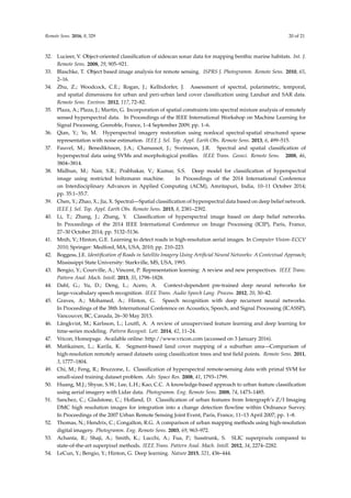
The problematic classes can be further investigated by visualizing the classification results on a
whole region. Figure 12 shows the classification results on randomly-selected regions of the map.
It can be seen that the misclassifications of the road usually occur when the road is covered by
shadows. There is also a misclassification of the bridge over water that is classified as a building.
It can also be seen that dark buildings that are surrounded by forests are sometimes misclassified
as vegetation.](https://image.slidesharecdn.com/cnnacuraciaremotesensing-08-00329-210909210440/85/Cnn-acuracia-remotesensing-08-00329-14-320.jpg)
![Remote Sens. 2016, 8, 329 15 of 21
Table 3. Comparison of classification accuracy (%) with previous methods. OBIA, object-based image
analysis.
Method Overall Accuracy (%) Data Categories
Fuzzy C means [73] 68.9% Aerial image, laser scanning
4 (vegetation, buildings, roads,
open areas)
Segmentation and
classification tree
method [52]
70% Multispectral aerial imagery
5 (water, pavement, rooftop,
bare ground, vegetation)
Classification Trees and
TFP [48]
74.3% Aerial image
4 (building, tree, ground, soil)
Segmentation and
classification rules [51]
75.0%
Multispectral aerial
imagery
6 (building, hard standing,
grass, trees, bare soil, water)
Region-based GeneSIS [66] 89.86% Hyperspectral image
9 (asphalt, meadows, gravel,
trees, metal sheets, bare soil,
bitumen, bricks, shadows)
OBIA [31] 93.17%
Aerial orthophotography
and DEM
7 (buildings, roads, water, grass,
tree, soil, cropland)
Knowledge-based method [50] 93.9%
Multispectral aerial
imagery, laser
scanning, DSM
4 (buildings, trees, roads, grass)
Single CNN (L = 1,
N = 1, m = 25) 90.02% ± 0.14%
Multispectral
orthophotography
imagery, DSM
5 (vegetation, ground, road,
building, water)
Multiple CNNs (L = 1,
N = 4,
m = [15, 25, 35, 45])
94.49% ± 0.04%
Multispectral
orthophotography
imagery, DSM
5 (vegetation, ground, road,
building, water)
Table 4. Confusion matrix for a randomly-drawn test set. Each category contains around 4000
validation points each.
Predicted
% Vegetation Ground Road Building Water
True label
Vegetation 99.65 0.01 0.0 0.34 0.0
Ground 0.13 82.88 15.50 0.91 0.59
Road 0.0 6.17 93.14 0.64 0.06
Building 1.00 0.34 1.26 97.17 0.23
Water 0.17 0.13 0.04 0.03 99.63
3.4. Post-Processing Results
In this section, we show how the post-processing techniques described in Section 2.6 are used to
smooth out the classification result and how the pre-defined segments are merged. We illustrate the
effects of the post-processing techniques on a small 250 × 250 pixel segment of the map.
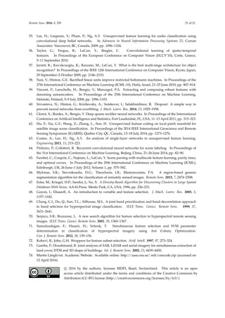
3.4.1. Effects of Classification Averaging
The effects of classification averaging can be seen in Figure 13. The left figure shows the selected
region, which contains all five classes. The middle figure shows the classification of all pixels without
any averaging. It can be seen that there are some salt-and-pepper misclassifications, e.g., small islands
in the river, small puddles of water on the ground, trees being classified as buildings and patches of
ground in the middle of the road. Furthermore, the shadows from the buildings cause the road to be
misclassified as ground. The right figure shows the result after averaging, and it can be seen that the
salt-and-pepper effects have been removed.](https://image.slidesharecdn.com/cnnacuraciaremotesensing-08-00329-210909210440/85/Cnn-acuracia-remotesensing-08-00329-15-320.jpg)
![Remote Sens. 2016, 8, 329 17 of 21
that a post-processing step of classification averaging is still necessary to achieve a good performance
when using a pixel-based classification approach.
Table 5. Performance comparison between using and not using pixel classification averaging.
Method
Classification Accuracy
without Averaging (%)
Classification Accuracy
with Averaging (%)
Single CNN (L = 1, N = 1, m = 25) 84.67 ± 0.16 90.02% ± 0.14%
Multiple CNNs (L = 1, N = 4,
m = [15, 25, 35, 45])
87.34 ± 0.05 94.49% ± 0.04%
3.4.2. Effects of Region Merging
The region merging process is done by first segmenting each 250 by 250 pixel area into
approximately 500 segments using the SLIC algorithm and then merging the segments based on
the averaged classifications. The effects of region merging can be seen in Figure 14. The left figure
shows the selected region. The middle figure shows the initial segmentation using SLIC. It can be
seen that individual objects, such as buildings, are poorly segmented, contain multiple segments
and sometimes are merged together from the shadow on the ground. The right figure shows the
segmentation after the merging of segments. The merging is based on the predicted class of each
segment, as well as the prediction certainty. Each pixel that is classified with the softmax classifier
returns the class and the classification certainty. The merging of two neighboring segments is done
if the two segments are classified as the same class with certainty over a certain threshold. We
empirically set this threshold at 70%, meaning that two adjacent segments were merged if the average
classification accuracy of all pixels within each segment were over this threshold. It can be seen that
the number of segments is fewer, that they are of varying sizes after the merging and that they better
represent real-world objects. This shows that the process of segmentation does not necessarily only
have to depend on the input data, but can also depend on the predictions from a per-pixel classifier.
50 m
Figure 14. This figure illustrates the effects of region merging. Left: Selected region in RGB. Middle:
Initial segmentation using the SLIC algorithm where each region is of equal size. Right: Segmentation
after nearby segments that have the same predicted class with over 70% classification certainty have
been merged. The segments after the merging have varying sizes and more accurately represent
real-world objects.
4. Conclusions
We have shown how a CNN can be used for per-pixel classification and later used for improving
the segmentation. A large area of a town was fully labeled on the pixel-level into five classes:
vegetation, ground, road/parking/railroad, building and water. The choices for the architecture
parameters of a single-layered CNN were evaluated and used for classification. It was discovered](https://image.slidesharecdn.com/cnnacuraciaremotesensing-08-00329-210909210440/85/Cnn-acuracia-remotesensing-08-00329-17-320.jpg)
![Remote Sens. 2016, 8, 329 18 of 21
that a context size of around 25 pixels, a filter size and a pooling dimension that resulted in under
600 output units and a low number of filters, namely 50, were able to achieve a stable and high
classification accuracy, while still keeping a low training and testing simulation time. Using higher
contextual areas of 35 and 45 resulted in slightly higher classification accuracies, but the result
was more unstable and had a longer simulation time. Building on this discovery, multiple CNNs
in parallel with varying context areas were used to achieve a stable and accurate classification
result. A combination of four CNNs with varying contextual size that ran in parallel achieved the
best classification accuracy of 94.49%. Deep single CNNs were also tested, but did not increase
the classification accuracy. The filters in the CNN were pre-trained with a fast unsupervised
clustering algorithm, and the fully-connected layer and softmax classifier were fine-tuned with
backpropagation. The classifications were smoothed out with averaging over each pre-generated
segment from an image segmentation method. The segments were then merged using the information
from the classifier in order to get a segmentation that better represents real-world objects.
Future work includes investigating the use of a CNN for pixel classification in an unsupervised
fashion using unlabeled data. Another direction for future work is to develop a method that better
deals with shadows. Shadows are artifacts that are inherent in orthographic images and difficult for
a CNN to reason about. A top-down reasoning approach could be used to infer estimated locations
for shadows and use this relationship information in order to change the classifications of segments
with low prediction certainty.
The MATLAB code that was used for this work can be downloaded at [74].
Acknowledgments: This work has been supported by the Swedish Knowledge Foundation under the research
profile on Semantic Robots, contract number 20140033.
Author Contributions: All authors conceived and designed the experiments; M.L. and A.K. and M.A. performed
the experiments; M.L. analyzed the data; M.L. and A.K. and M.A. contributed reagents/materials/analysis tools;
M.L. and A.K. and M.A. wrote the paper. All authors read and approved the submitted manuscript.
Conflicts of Interest: The authors declare no conflict of interest.
References
1. Reed, B.; Brown, J.; Vanderzee, D.; Loveland, T.; Merchant, J.; Ohlen, D. Measuring phenological variability
from satellite imagery. J. Veg. Sci. 1994, 5, 703–714.
2. Running, S.; Nemani, R.; Heinsch, F.; Zhao, M.; Reeves, M.; Hashimoto, H. A continuous satellite-derived
measure of global terrestrial primary production. BioScience 2004, 54, 547–560.
3. Glenn, N.; Mundt, J.; Weber, K.; Prather, T.; Lass, L.; Pettingill, J. Hyperspectral data processing for repeat
detection of small infestations of leafy spurge. Remote Sens. Environ. 2005, 95, 399–412.
4. Netanyahu, N.; Le Moigne, J.; Masek, J. Georegistration of Landsat data via robust matching of
multiresolution features. IEEE Trans. Geosci. Remote Sens. 2004, 42, 1586–1600.
5. Benediktsson, J.A.; Chanussot, J.; Moon, W.M. Advances in very-high-resolution remote sensing. IEEE Proc.
2013, 101, 566–569.
6. Weng, Q.; Lu, D.; Schubring, J. Estimation of land surface temperature-vegetation abundance relationship
for urban heat island studies. Remote Sens. Environ. 2004, 89, 467–483.
7. Peña-Barragán, J.M.; Ngugi, M.K.; Plant, R.E.; Six, J. Object-based crop identification using multiple
vegetation indices, textural features and crop phenology. Remote Sens. Environ. 2011, 115, 1301–1316.
8. Pradhan, B.; Lee, S. Delineation of landslide hazard areas on Penang Island, Malaysia, by using frequency
ratio, logistic regression, and artificial neural network models. Environ. Earth Sci. 2010, 60, 1037–1054.
9. Yang, Y.; Newsam, S. Bag-of-visual-words and spatial extensions for land-use classification. In Proceedings
of the ACM International Symposium on Advances in Geographic Information Systems, San Jose, CA, USA,
2–5 November 2010; pp. 270–279.
10. Lai, K.; Bo, L.; Ren, X.; Fox, D. A large-scale hierarchical multi-view RGB-D object dataset. In Proceedings
of the IEEE International Conference on Robotics and Automation, Shanghai, China, 9–13 May 2011;
pp. 1817–1824.](https://image.slidesharecdn.com/cnnacuraciaremotesensing-08-00329-210909210440/85/Cnn-acuracia-remotesensing-08-00329-18-320.jpg)


This document discusses using convolutional neural networks (CNNs) to classify and segment satellite imagery. It presents a novel approach using a CNN to perform per-pixel classification of multispectral satellite imagery and a digital surface model into five categories (vegetation, ground, roads, buildings, water). The CNN is first pre-trained with unsupervised clustering then fine-tuned for classification and segmentation. Results show the CNN approach outperforms existing methods, achieving 94.49% classification accuracy and improving segmentation by reducing salt-and-pepper effects from per-pixel classification alone.