Downloaded 34 times


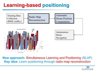
![Offline path planning
-
[1] R.Gangula, D.Gesbert, et.al “Trajectory Optimization for Mobile Access Point” Accepted in Asilomar 2017.
[2]A. T. Klesh, P. T. Kabamba, and A. R. Girard, “Path planning for cooperative time-optimal information collection,” in American
Control Conference, June 2008, pp. 1991–1996.
[3] Q. Wu, Y. Zeng, and R. Zhang, “Joint Trajectory and Communication Design for UAV-Enabled Multiple Access,” , Apr. 2017.
Small/Moderate flying budget Large flying budget](https://image.slidesharecdn.com/machinelearningforflyingradio-180130153743/85/Machine-learning-for-decentralized-and-flying-radio-devices-10-320.jpg)
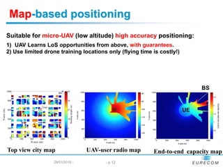
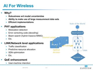
![Machine Learning for 3D map reconstruction
Proposed concept:
1- Learn propagation parameters using previous EM algorithm
2- Soft-classify users into LoS/NLoS
3- Reconstruct 3D map from “radio shadow” data
Connections with
-3D Imaging with WiFi [Y. Mostofi et al. @ UCSB]
-GPS based 3D imaging [Madhow et al @ UCSB]
[Esrafilian, Gesbert, Globecom 2017]](https://image.slidesharecdn.com/machinelearningforflyingradio-180130153743/85/Machine-learning-for-decentralized-and-flying-radio-devices-16-320.jpg)
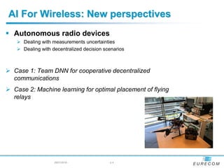
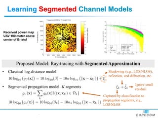
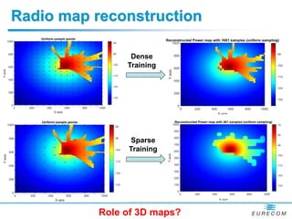
![Joint 3D and radio map reconstruction
17
An orthoimagery of
an area at center
Washington DC, USA
[Chen, Esrafilian, Gesbert, Mitra, Robotics, Science and Systems, MIT, 2017]
Radio map
reconstruction
SNR/Radio map estimate
3D city map estimate
Joint approach](https://image.slidesharecdn.com/machinelearningforflyingradio-180130153743/85/Machine-learning-for-decentralized-and-flying-radio-devices-17-320.jpg)


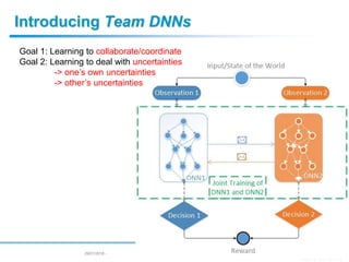
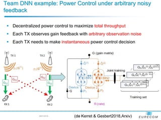
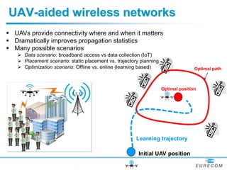
The document discusses advancements in machine learning applications for decentralized and flying radio devices, emphasizing their robustness and efficiency in handling model uncertainties and large datasets. It explores various use cases, including modulation detection, resource allocation, and optimal placement of flying relays, highlighting the need for collaboration and coordination in decentralized wireless networks. Additionally, it introduces team deep neural networks (DNNs) for improving power control and discusses learning-based positioning through radio map reconstruction for enhanced communication in UAV-assisted networks.