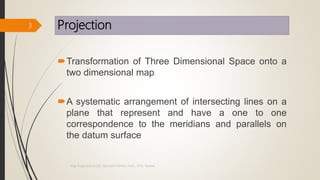
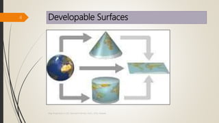
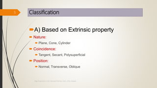
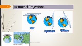
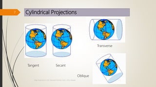
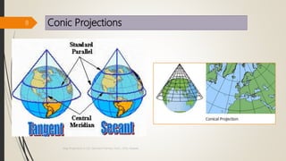
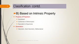
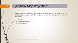
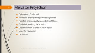
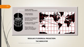
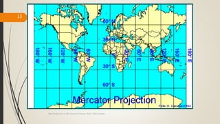
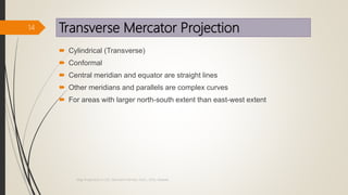
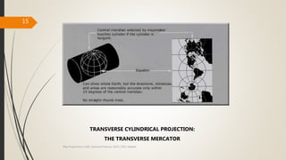
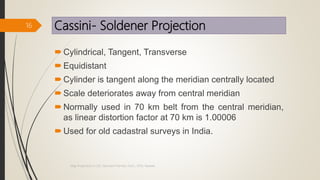
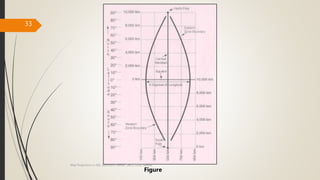
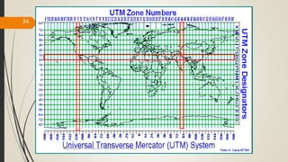
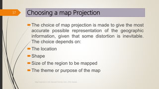
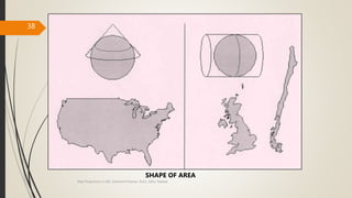
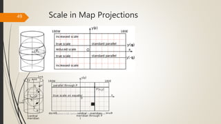
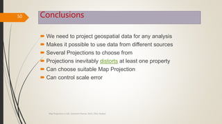
One of most important topics in ArcGIS and GIS, is coordinate system, the slides will cover this topic in order to understand the difference between various coordinate systems.
Photograph taken from an aircraft commonly termed as aerial photograph have come to play and ever increasing role in the execution in cartographic mapping in various scales and in evaluation of natural resources of a region. Uses of aerial photographs in other fields are also manifold; in fact the scope seems limitless.
Digital Elevation Model (DEM) is the digital representation of the land surface elevation with respect to any reference datum. DEM is frequently used to refer to any digital representation of a topographic surface. DEM is the simplest form of digital representation of topography. GIS applications depend mainly on DEMs, today.
Understanding Coordinate Systems and Projections for ArcGISJohn Schaeffer
Everything you need to know to work with coordinate systems and projecting data in ArcGIS. The presentation starts by explaining the terminology, and then discusses the details you need to know to actually work successfully with coordinate systems, use the proper projections, and geographic transformations. This is a very practical look at a complex subject.
Map projection is a systematic drawing of parallel of latitudes and meridians of longitude on a plane surface for the whole earth or a part of it on a certain scale so that any point on the earth surface may correspond to that on the drawing.
Maps cannot be created without map projections. All map projections necessarily distort the surface in some fashion.
Depending on the purpose of the map, some distortions are acceptable and others are not; therefore, different map projections exist in order to preserve some properties of the sphere-like body at the expense of other properties.
There is no limit to the number of possible map projections.
Photogrammetry: Stereoscopy and ParallaxAhmed Nassar
This literature review talks about the principles of stereoscopy and the stereoscopic instruments used, in addition to the steps for correcting the rotation of photos under the stereoscope, then talks about the Y-Parallax which result of Principal points line not parallel with Flight line. also, the stereoscopic parallax principles and it's measurement.
Different types of Important projection systems & Coordinate systems.Every country would like to represent it's self in true shape, if shape changes then size , area also changes so that leads to distortions on the global properties of a map like Distance,direction,shape ,Area. so no country or continent will never like to represent themselves distorted , so hundreds of projections were developed by counties across the world.
Cartography is the science of map making related to geography, mathematics, geodesy, and human habitat, economy and society. Its a discipline developed during the early period of human civilization. With the development of science and technology, it has changed its paradigm twice. Its been digital, more integrated and very useful global media for communication.
Introduction to various GIS software, google earth. Intro types, types of maps, map projections and hands on to Q GIS software. Introduction to latitude longitude system, shape file generation, geo referencing and digitization.
Cartography is the art, science and technology of map making.
Maps are used as research tools and as sources of information.
Maps have existed since the time of the Egyptian, Mesopotamian and Chinese civilizations, with the latter maps dating back to 6000 years.
Coordinate system Geographical coordinate systemNaresh Kumar
UTm Universe transvers mercator, Geographic coordinate system
geoid, planar projection, cylindrical and conical projection, longitudinal, latitude, UTM zones 60 zones
When to be silent?;
Circumstances to remain silent;
Situations to be silent;
Silent at some points;
Silent in a few circumstances;
time to remain silent;
remain silent in these situations; a guide to remain silent against whom and when?
Spiritual;
Social;
Hinduism;
Know Hinduism;
What is Hinduism?;
Sanatana Dharma;
Why sanatana Dharma?;
What is special in Sanatana Dharma?;
Special @ Sanatana Dharma;
Why adopt Hinduism?;
Why adopt Sanatana Dharma? ;
Philosophy of Sanatana Dharma;
Philosophy of life;
Effect of gradation of sands;
Particle size effect on DCP;
Relative density of sand;
ASTM D6951-03;
Depth of penetration vs blows;
DCP vs Relative density;
DCP index vs gradation of sand;
Experimental Investigation;
Conference paper;
year 2017; Effect of Gradation and Particle Size on
Correlations between DCP Index and Relative density of sands
Presiding duty for the 2024 election;
Key Points;
Points to take care of: Presiding officer;
Presiding Key Points;
Things to carry- for officers:
Presiding officer duty list;
Gujarati presiding officer duty;
All instructions and flow chart in Gujarati,
Gujarati: presiding officer Key Points;
Indian Traditional jewelry;
pre-independence era jewelry design;
Indian ornament design;
100-year-old Indian jewelry
Usefulness of ancient indian Jwelry design;
One more chance
Philosophy of life;
How conscious we?
For conscious human beings only,
way of life; Live your life;
Enjoy being human being;
What happens when we are dead?
What do we achieve in life?
Pre-Independence Toys and Crafts designs in India.pptxSamirsinh Parmar
Pre-independence toys;
Crafts and Toys of India;
Toys and Crafts before 1947 In india;
Toys and crafts in India;
Traditional toys of India
Traditional wooden toys in India;
Traditional clay toys of India;
Traditional metal toys of India;
INTRODUCTION TO GLOBAL POSITIONING SYSTEM (GPS).pptxSamirsinh Parmar
What is GPS?;
Definition of GPS;
GPS;
Global Positioning System;
How GPS works?;
Working principle-GPS;
One way ranging;
Determining the position;
The clock problem;
PRC amplification;
Pseudo-range;
Different types of GPS locations;
NAVSTAR System;
Accuracy of GPS;
Applications of GPS; Advantages of One-Way Ranging; Pseudo Random Code;
PRC;
BEAUTY OF MATHEMATICS- Tricks of Calculations.pptxSamirsinh Parmar
The beauty of mathematics
Mathematics thumb rules;
Tricks in mathematics;
Easy math calculations
Vedic Mathematics;
Joy of numbers in Math;
Enjoying tricks in Math; mathematics, and English aplhabets; relation of attitude, hardwork, blessings of God, etc.
TIBETIAN PERSONALITY TEST - FEW QUESTION ANSWERSSamirsinh Parmar
Tibetian personality test;
Know your personality;
Know your preferences in life;
Know to whom you love;
Questions and Answers;
Spare some time; Share it to your near and dear; Know who loves you?
The Endangered And Extinct Languages Of India.pptxSamirsinh Parmar
The Endangered Languages;
Indian Languages- Extinction;
Maithili;
Magadhi;
Bhojpuri;
Extincted Languages of India;
Reasons of Extinction of Languages;
How to save languages from extinction ?;
Contribution to stop extinction of languages;
UNESCO report on extinct languages
GraphSummit Singapore | The Art of the Possible with Graph - Q2 2024Neo4j
Neha Bajwa, Vice President of Product Marketing, Neo4j
Join us as we explore breakthrough innovations enabled by interconnected data and AI. Discover firsthand how organizations use relationships in data to uncover contextual insights and solve our most pressing challenges – from optimizing supply chains, detecting fraud, and improving customer experiences to accelerating drug discoveries.
Sudheer Mechineni, Head of Application Frameworks, Standard Chartered Bank
Discover how Standard Chartered Bank harnessed the power of Neo4j to transform complex data access challenges into a dynamic, scalable graph database solution. This keynote will cover their journey from initial adoption to deploying a fully automated, enterprise-grade causal cluster, highlighting key strategies for modelling organisational changes and ensuring robust disaster recovery. Learn how these innovations have not only enhanced Standard Chartered Bank’s data infrastructure but also positioned them as pioneers in the banking sector’s adoption of graph technology.
zkStudyClub - Reef: Fast Succinct Non-Interactive Zero-Knowledge Regex ProofsAlex Pruden
This paper presents Reef, a system for generating publicly verifiable succinct non-interactive zero-knowledge proofs that a committed document matches or does not match a regular expression. We describe applications such as proving the strength of passwords, the provenance of email despite redactions, the validity of oblivious DNS queries, and the existence of mutations in DNA. Reef supports the Perl Compatible Regular Expression syntax, including wildcards, alternation, ranges, capture groups, Kleene star, negations, and lookarounds. Reef introduces a new type of automata, Skipping Alternating Finite Automata (SAFA), that skips irrelevant parts of a document when producing proofs without undermining soundness, and instantiates SAFA with a lookup argument. Our experimental evaluation confirms that Reef can generate proofs for documents with 32M characters; the proofs are small and cheap to verify (under a second).
Paper: https://eprint.iacr.org/2023/1886
Building RAG with self-deployed Milvus vector database and Snowpark Container...Zilliz
This talk will give hands-on advice on building RAG applications with an open-source Milvus database deployed as a docker container. We will also introduce the integration of Milvus with Snowpark Container Services.
In the rapidly evolving landscape of technologies, XML continues to play a vital role in structuring, storing, and transporting data across diverse systems. The recent advancements in artificial intelligence (AI) present new methodologies for enhancing XML development workflows, introducing efficiency, automation, and intelligent capabilities. This presentation will outline the scope and perspective of utilizing AI in XML development. The potential benefits and the possible pitfalls will be highlighted, providing a balanced view of the subject.
We will explore the capabilities of AI in understanding XML markup languages and autonomously creating structured XML content. Additionally, we will examine the capacity of AI to enrich plain text with appropriate XML markup. Practical examples and methodological guidelines will be provided to elucidate how AI can be effectively prompted to interpret and generate accurate XML markup.
Further emphasis will be placed on the role of AI in developing XSLT, or schemas such as XSD and Schematron. We will address the techniques and strategies adopted to create prompts for generating code, explaining code, or refactoring the code, and the results achieved.
The discussion will extend to how AI can be used to transform XML content. In particular, the focus will be on the use of AI XPath extension functions in XSLT, Schematron, Schematron Quick Fixes, or for XML content refactoring.
The presentation aims to deliver a comprehensive overview of AI usage in XML development, providing attendees with the necessary knowledge to make informed decisions. Whether you’re at the early stages of adopting AI or considering integrating it in advanced XML development, this presentation will cover all levels of expertise.
By highlighting the potential advantages and challenges of integrating AI with XML development tools and languages, the presentation seeks to inspire thoughtful conversation around the future of XML development. We’ll not only delve into the technical aspects of AI-powered XML development but also discuss practical implications and possible future directions.
Threats to mobile devices are more prevalent and increasing in scope and complexity. Users of mobile devices desire to take full advantage of the features
available on those devices, but many of the features provide convenience and capability but sacrifice security. This best practices guide outlines steps the users can take to better protect personal devices and information.
Encryption in Microsoft 365 - ExpertsLive Netherlands 2024Albert Hoitingh
In this session I delve into the encryption technology used in Microsoft 365 and Microsoft Purview. Including the concepts of Customer Key and Double Key Encryption.
20 Comprehensive Checklist of Designing and Developing a WebsitePixlogix Infotech
Dive into the world of Website Designing and Developing with Pixlogix! Looking to create a stunning online presence? Look no further! Our comprehensive checklist covers everything you need to know to craft a website that stands out. From user-friendly design to seamless functionality, we've got you covered. Don't miss out on this invaluable resource! Check out our checklist now at Pixlogix and start your journey towards a captivating online presence today.
UiPath Test Automation using UiPath Test Suite series, part 6DianaGray10
Welcome to UiPath Test Automation using UiPath Test Suite series part 6. In this session, we will cover Test Automation with generative AI and Open AI.
UiPath Test Automation with generative AI and Open AI webinar offers an in-depth exploration of leveraging cutting-edge technologies for test automation within the UiPath platform. Attendees will delve into the integration of generative AI, a test automation solution, with Open AI advanced natural language processing capabilities.
Throughout the session, participants will discover how this synergy empowers testers to automate repetitive tasks, enhance testing accuracy, and expedite the software testing life cycle. Topics covered include the seamless integration process, practical use cases, and the benefits of harnessing AI-driven automation for UiPath testing initiatives. By attending this webinar, testers, and automation professionals can gain valuable insights into harnessing the power of AI to optimize their test automation workflows within the UiPath ecosystem, ultimately driving efficiency and quality in software development processes.
What will you get from this session?
1. Insights into integrating generative AI.
2. Understanding how this integration enhances test automation within the UiPath platform
3. Practical demonstrations
4. Exploration of real-world use cases illustrating the benefits of AI-driven test automation for UiPath
Topics covered:
What is generative AI
Test Automation with generative AI and Open AI.
UiPath integration with generative AI
Speaker:
Deepak Rai, Automation Practice Lead, Boundaryless Group and UiPath MVP
Removing Uninteresting Bytes in Software FuzzingAftab Hussain
Imagine a world where software fuzzing, the process of mutating bytes in test seeds to uncover hidden and erroneous program behaviors, becomes faster and more effective. A lot depends on the initial seeds, which can significantly dictate the trajectory of a fuzzing campaign, particularly in terms of how long it takes to uncover interesting behaviour in your code. We introduce DIAR, a technique designed to speedup fuzzing campaigns by pinpointing and eliminating those uninteresting bytes in the seeds. Picture this: instead of wasting valuable resources on meaningless mutations in large, bloated seeds, DIAR removes the unnecessary bytes, streamlining the entire process.
In this work, we equipped AFL, a popular fuzzer, with DIAR and examined two critical Linux libraries -- Libxml's xmllint, a tool for parsing xml documents, and Binutil's readelf, an essential debugging and security analysis command-line tool used to display detailed information about ELF (Executable and Linkable Format). Our preliminary results show that AFL+DIAR does not only discover new paths more quickly but also achieves higher coverage overall. This work thus showcases how starting with lean and optimized seeds can lead to faster, more comprehensive fuzzing campaigns -- and DIAR helps you find such seeds.
- These are slides of the talk given at IEEE International Conference on Software Testing Verification and Validation Workshop, ICSTW 2022.
How to Get CNIC Information System with Paksim Ga.pptxdanishmna97
Pakdata Cf is a groundbreaking system designed to streamline and facilitate access to CNIC information. This innovative platform leverages advanced technology to provide users with efficient and secure access to their CNIC details.
Observability Concepts EVERY Developer Should Know -- DeveloperWeek Europe.pdfPaige Cruz
Monitoring and observability aren’t traditionally found in software curriculums and many of us cobble this knowledge together from whatever vendor or ecosystem we were first introduced to and whatever is a part of your current company’s observability stack.
While the dev and ops silo continues to crumble….many organizations still relegate monitoring & observability as the purview of ops, infra and SRE teams. This is a mistake - achieving a highly observable system requires collaboration up and down the stack.
I, a former op, would like to extend an invitation to all application developers to join the observability party will share these foundational concepts to build on:
Full-RAG: A modern architecture for hyper-personalizationZilliz
Mike Del Balso, CEO & Co-Founder at Tecton, presents "Full RAG," a novel approach to AI recommendation systems, aiming to push beyond the limitations of traditional models through a deep integration of contextual insights and real-time data, leveraging the Retrieval-Augmented Generation architecture. This talk will outline Full RAG's potential to significantly enhance personalization, address engineering challenges such as data management and model training, and introduce data enrichment with reranking as a key solution. Attendees will gain crucial insights into the importance of hyperpersonalization in AI, the capabilities of Full RAG for advanced personalization, and strategies for managing complex data integrations for deploying cutting-edge AI solutions.
GraphSummit Singapore | The Future of Agility: Supercharging Digital Transfor...Neo4j
Leonard Jayamohan, Partner & Generative AI Lead, Deloitte
This keynote will reveal how Deloitte leverages Neo4j’s graph power for groundbreaking digital twin solutions, achieving a staggering 100x performance boost. Discover the essential role knowledge graphs play in successful generative AI implementations. Plus, get an exclusive look at an innovative Neo4j + Generative AI solution Deloitte is developing in-house.
3. Projection
Transformation of Three Dimensional Space onto a
two dimensional map
A systematic arrangement of intersecting lines on a
plane that represent and have a one to one
correspondence to the meridians and parallels on
the datum surface
3
Map Projections in GIS, Samirsinh Parmar, DoCL, DDU, Nadiad.
9. Classification contd.
B) Based on Intrinsic Property
Property of Projection:
Equidistant
Conformal or Orthomorphic
Equivalent or Equal area
Generation:
Geometric, Semi Geometric, Mathematical
9
Map Projections in GIS, Samirsinh Parmar, DoCL, DDU, Nadiad.
10. Cylindrical Map Projections
Cylindrical map projections are made by projecting from the globe onto the
surface of an enclosing cylinder, and then unwrapping the cylinder to make a
flat surface
Mercator
Transverse Mercator
Cassini-Soldner
10
Map Projections in GIS, Samirsinh Parmar, DoCL, DDU, Nadiad.
11. Mercator Projection
Cylindrical, Conformal
Meridians are equally spaced straight lines
Parallels are unequally spaced straight lines
Scale is true along the equator
Great distortion of area in polar region
Used for navigation
Limitations
11
Map Projections in GIS, Samirsinh Parmar, DoCL, DDU, Nadiad.
14. Transverse Mercator Projection
Cylindrical (Transverse)
Conformal
Central meridian and equator are straight lines
Other meridians and parallels are complex curves
For areas with larger north-south extent than east-west extent
14
Map Projections in GIS, Samirsinh Parmar, DoCL, DDU, Nadiad.
16. Cassini- Soldener Projection
Cylindrical, Tangent, Transverse
Equidistant
Cylinder is tangent along the meridian centrally located
Scale deteriorates away from central meridian
Normally used in 70 km belt from the central meridian,
as linear distortion factor at 70 km is 1.00006
Used for old cadastral surveys in India.
16
Map Projections in GIS, Samirsinh Parmar, DoCL, DDU, Nadiad.
18. Conic Projections
18
For a conic projection, the
projection surface is cone shaped
Locations are projected onto the
surface of the cone which is then
unwrapped and laid flat
Map Projections in GIS, Samirsinh Parmar, DoCL, DDU, Nadiad.
19. Lambert Conformal Conic Projection
Conical, Conformal
Parallels are concentric arcs
Meridians are straight lines cutting parallels at right angles.
Scale is true along two standard parallels, normally, or along
just one.
It projects a great circle as a straight line – much better than
Mercator
Used for maps of countries and regions with predominant
east west expanse
Used for plane coordinate system (SPCS) in USA
19
Map Projections in GIS, Samirsinh Parmar, DoCL, DDU, Nadiad.
22. Polyconic Projection
In this projection all parallels are projected without
any distortion
Scale is exact along each parallel and central
meridian.
Parallels are arcs of circles but are not concentric.
It is neither conformal nor equal area.
22
Map Projections in GIS, Samirsinh Parmar, DoCL, DDU, Nadiad.
23. Polyconic Projection contd.
Central meridian and equator are straight lines;
all other meridians are curves.
Central Meridian cuts all parallels at 90 degrees
Free of distortion only along the central
meridian.
It has rolling fit with adjacent sheets in EW
direction.
Used in India for all topographical mapping on
1:250,000 and larger scales.
23
Map Projections in GIS, Samirsinh Parmar, DoCL, DDU, Nadiad.
24. 24
Three partial equidistant conic maps, each based on a different standard
parallel, therefore wrapped on a different tangent cone (shown on the right
with a quarter removed plus tangency parallels). When the number of cones
increases to infinity, each strip infinitesimally narrow, the result is a
continuous polyconic projection
Map Projections in GIS, Samirsinh Parmar, DoCL, DDU, Nadiad.
26. Azimuthal Projections
For an azimuthal, or planar projection, projected forward onto
a flat plane.
The normal aspect for these projections is the North or South
Pole. locations are
26
Map Projections in GIS, Samirsinh Parmar, DoCL, DDU, Nadiad.
27. Universal Polar Stereographic (UPS)
Defined above 84 degrees north latitude and 80 degree south
Conformal
Meridians are straight lines
Parallels are circles
Scale increases from center point
Used in conformal mapping of polar regions
27
Map Projections in GIS, Samirsinh Parmar, DoCL, DDU, Nadiad.
29. Grids
Rectangular grids have been developed for the use of Surveyors.
Each point can be designated merely by its ( x , y ) co-ordinates.
Grid systems are normally divided into zones so that distortion and
variation of scale within any one zone are kept small.
The UTM grid
State Plane Coordinate System (SPCS)
29
Map Projections in GIS, Samirsinh Parmar, DoCL, DDU, Nadiad.
30. False Northing and False Easting
Calculating coordinates is easier if negative number aren’t involved.
Indian Grid and Universal transverse Mercator coordinates
Expressed in coordinate units, not degrees.
30
Map Projections in GIS, Samirsinh Parmar, DoCL, DDU, Nadiad.
31. 31
SPECIFYING AN ORIGIN SHIFT:
THE FALSE EASTING AND FALSE NORTHING
Central Meridian
Natural Origin
Central Parallel
Coordinate System
Origin
False Easting
False
Northing
Map Projections in GIS, Samirsinh Parmar, DoCL, DDU, Nadiad.
32. Universal Transverse Mercator (UTM)
Particular case of Transverse Mercator Projection.
The earth between latitudes 84 N and 80 S, is divided
into 60, 6 wide strips;
Latitude origin – the Equator
Assumed (false) northing (y) at Equator
0 m for northern hemisphere
10,000,000 m for southern hemisphere
Assumed (false) easting (x) at Central Meridian
500,000 m
Scale factor at the central meridian : 0.9996
32
Map Projections in GIS, Samirsinh Parmar, DoCL, DDU, Nadiad.
35. Projection Parameters
To define the coordinate system completely, it is not
sufficient simply to name the kind of projection used,
it is also necessary to specify the projection
parameters.
The set of parameters required depends on the kind of
projection.
The central meridian of the projection for cylindrical,
where it touches the ellipsoid surface.
35
Map Projections in GIS, Samirsinh Parmar, DoCL, DDU, Nadiad.
36. Projection Parameterscontd.
The standard parallel(s) for conic projections.
The false easting and false northing
The units
Reference ellipsoid
36
Map Projections in GIS, Samirsinh Parmar, DoCL, DDU, Nadiad.
37. Choosing a map Projection
The choice of map projection is made to give the most
accurate possible representation of the geographic
information, given that some distortion is inevitable.
The choice depends on:
The location
Shape
Size of the region to be mapped
The theme or purpose of the map
37
Map Projections in GIS, Samirsinh Parmar, DoCL, DDU, Nadiad.
39. Some Related Terms
Coordinate System
Reference Ellipsoids
Everest Ellipsoid
GRS 80
WGS 84
39
Map Projections in GIS, Samirsinh Parmar, DoCL, DDU, Nadiad.
40. Implications for GIS
Knowing the datum and reference ellipsoid
information is very important.
For converting the maps of one system to another
system.
When incorporating maps or GPS field data into a
GIS
40
Map Projections in GIS, Samirsinh Parmar, DoCL, DDU, Nadiad.
41. Coordinate System
Need to describe the location, i.e. referencing
network by which positions are measured and
computed.
Relative location (with respect to some other place).
E.g. Street address.
• Absolute location (with respect to the Earth as a
whole).
E.g. Geographic coordinates
41
Map Projections in GIS, Samirsinh Parmar, DoCL, DDU, Nadiad.
42. Objects in Real World
(Earth)
Geographic Coordinates
( ø , λ )
Represented on Paper
or Screen
(Map)
Planar Coordinates
( x , y )
Map Projections in GIS, Samirsinh Parmar, DoCL, DDU, Nadiad.
42
43. REFERENCE ELLIPSOID
All the measurements are done on the surface of the Earth.
Various computations are required to determine the
coordinates, distances, area etc.
The surface of the earth is irregular and therefore unsuitable
for such computations. We need a smooth mathematical
surface for these computations.
The best mathematical figure that can represent the earth is
an ellipsoid. Ellipsoid is used as reference surface.
43
Map Projections in GIS, Samirsinh Parmar, DoCL, DDU, Nadiad.
44. TYPES OF ELLIPSOIDS
1. Best-Fit Ellipsoid/Local Ellipsoid: based on the measurements
within a region, so it best fits that region only. The centre of
such reference ellipsoid does not coincide with the centre of
gravity of the Earth.
Example : Everest Ellipsoid
2. Geocentric Ellipsoid: The centre of geocentric ellipsoid
coincides with the centre of the Earth. This type of the
ellipsoid can be used worldwide.
Example : WGS 84 ellipsoid
44
Map Projections in GIS, Samirsinh Parmar, DoCL, DDU, Nadiad.
45. 45
Best Fit and Geocentric Ellipsoids
Centre of Best Fit
Ellipsoid
Centre of Geocentric Ellipsoid
Best Fit
Ellipsoid
Geocentric Ellipsoid
Earth Surface
Best Fit
Ellipsoid
Map Projections in GIS, Samirsinh Parmar, DoCL, DDU, Nadiad.
46. DATUM
Datum is a model that describes the position,
direction, and scale relationships of a reference
surface to positions on the surface of Earth
Indian Datum
WGS 84
ITRF
46
Map Projections in GIS, Samirsinh Parmar, DoCL, DDU, Nadiad.
47. Scale
Only on a globe is a scale constant. It is impossible
to have a constant scale in different areas of a map
(but we can get close)
Map has fixed scale but GIS is scale-less, i.e. data
may be enlarged or reduced to any size.
However, if we go too far from the scale at which
map was made before it was captured into the GIS,
problems of scale appear.
47
Map Projections in GIS, Samirsinh Parmar, DoCL, DDU, Nadiad.
48. Map Distance
Scale = -----------------------------
Ground Distance
Representative fraction (RF) is the ratio of distances on the map to the
same distance on the ground. E.g., 1 : 1,000,000 or 1/1,000,000
Statement (verbal) scale expresses the ratio in words. for 1 : 1,000,000 :
“One millimeter to one kilometer”
Bar scale is a linear graphical scale drawn on the map
48
Map Projections in GIS, Samirsinh Parmar, DoCL, DDU, Nadiad.
49. Scale in Map Projections
49
Map Projections in GIS, Samirsinh Parmar, DoCL, DDU, Nadiad.
50. Conclusions
We need to project geospatial data for any analysis
Makes it possible to use data from different sources
Several Projections to choose from
Projections inevitably distorts at least one property
Can choose suitable Map Projection
Can control scale error
50
Map Projections in GIS, Samirsinh Parmar, DoCL, DDU, Nadiad.