Introduction to MAPS,Coordinate System and Projection System
•Download as PPTX, PDF•
26 likes•9,185 views

This document discusses key concepts in GIS including maps, coordinate systems, map projections, and their application in Nepal. It defines analog and digital maps, and explains that the earth is an ellipsoid rather than a perfect sphere. It introduces geographic and rectangular coordinate systems, and defines map projections as methods to represent the curved earth on a flat surface. The document outlines the Everest ellipsoid and UTM/MUTM projection systems used in Nepal.

Recommended
More Related Content
What's hot
What's hot (20)
Similar to Introduction to MAPS,Coordinate System and Projection System
Similar to Introduction to MAPS,Coordinate System and Projection System (20)
More from NAXA-Developers
Recently uploaded
Recently uploaded (20)
Introduction to MAPS,Coordinate System and Projection System
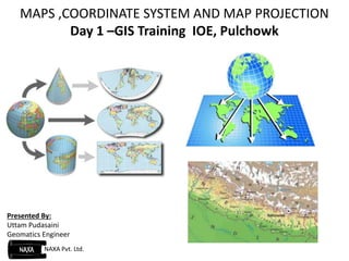
- 1. MAPS ,COORDINATE SYSTEM AND MAP PROJECTION Day 1 –GIS Training IOE, Pulchowk Presented By: Uttam Pudasaini Geomatics Engineer NAXA Pvt. Ltd.
- 2. Presentation Outline Basic Concepts: Maps Types of Maps: Analog and Digital Earth and its Shape: Geoids and Ellipsoids Coordinate System: Geographical and Rectangular Map Projection Coordinate System in Nepal Installation of Arc GIS Version 10.0
- 3. MAPS A graphical representation of ground reality Objects on the ground are reduced to a certain scale and represented on map Maps: Not a reality in itself
- 4. Analog Vs Digital MAPS Analog Maps Rigid form of map where message is conveyed by virtue of symbology. Measurable but not interactive. They are always projected. Difficult to integrate with other data. Digital Maps Maps in a digital media. Interactive options according to map’ objective. Maps can be in both 2D and 3D format. Easy integration with other data.
- 5. EARTH And its Shape (Misconceptions) Earth surface is a plane surface. If we are going to sail further, we are going to fall down one day. Rectangular Earth
- 6. Earth is in fact flattened slightly at the poles and bulges somewhat at the equator. Mathematical Shape of the earth : An Ellipsoid, A geometrical figure which would be obtained by rotating an ellipse about its shorter axis.
- 8. Geographical Coordinate System Uses latitude and longitude to represent the x,y position in space. Useful for locating positions on the curved surface of the earth. Rectangular Coordinate System Uses x,y coordinates to represent positions on a plane. The location of any point in this system is defined by a set of two values, p (x, y). Contd…
- 9. Map Projection Earth surface in reality is a curved surface with no perfect geometrical shape. Mapping in a globe is an easy way to map the earth. Measurement as well as sharing of data and details is always difficult if a map is represented on globe. Projection: A method by which the curved surface of the earth is represented on a flat surface.
- 10. Contd.. Includes two operations: Alteration of Scale. Transformation to Plane surface.
- 11. Numerous projections have been invented, and arguments continue about which is best for which purposes.
- 12. World Geodetic System - 1984 (WGS 84) A three dimensional Right handed Cartesian coordinate system followed around the globe. Origin = Earth’s centre of mass Z-Axis = Direction of the Conventional Terrestrial Pole X-Axis = Intersection of the WGS 84 reference meridian plane and the plane of the CTP’s equator. Y-Axis = Measured in the plane of the CTP equator, 90° East of the x-axis.
- 13. Coordinate System in Nepal
- 14. Everest Ellipsoid: Reference Ellipsoid being adopted by Nepal Semi major Axis ,a = 6377276.345 m Semi minor Axis ,b= 6356075.413 Flattening 1/ 300.8017 a b a f
- 15. Universal Transverse Mercator (UTM) Projection Introduced by US Army Map Service in the 1957. Most common system of projection used for large scale mapping around the world. Based on a Transverse Cylindrical projection. Cylinder touches the reference globe along a chosen meridian.
- 16. Consists of 60 zones. Each zone has a width of 60 of longitude. Zones are numbered sequentially from west to east, starting with 1. Zone 1= 1800W to 1740W, with CM 177 W.
- 17. MUTM Projection System Consists of 120 zones ,each of width 30 longitude Unit of measurement is meter. Scale factor at the central meridian = 0.9999. False Easting at Central Meridian =500000 m. False northing at the Equator is 0 m. False Easting and False Northing: Arbitrary large values are assigned to Y-axis origin and X-axis origin so called false easting and false northing respectively. Overcomes the inconveniences caused by the negative numbers in Rectangular Coordinate System.
- 18. Conclusion
- 19. Reading Materials Latitudes and Longitudes: https://www.youtube.com/watch?v=y6aPerEPbvw Coordinate System and Projections: https://www.youtube.com/watch?v=HifUBn4APZA