
Recommended
More Related Content
Similar to CEB 809 _L6_Map projection UTM Coordinates and Fiji.pptx
Similar to CEB 809 _L6_Map projection UTM Coordinates and Fiji.pptx (20)
Recently uploaded
Recently uploaded (20)
CEB 809 _L6_Map projection UTM Coordinates and Fiji.pptx
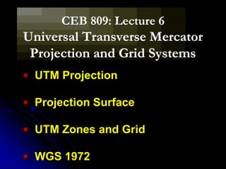
- 1. CEB 809: Lecture 6 Universal Transverse Mercator Projection and Grid Systems UTM Projection Projection Surface UTM Zones and Grid WGS 1972
- 3. The Variables in Map Projection Projection Orientation or Aspect Gnomonic Stereographic Orthographic Transverse Oblique Normal Plane Cylinder Cone
- 5. oGnomonic: The projection center is at the center of the ellipsoid. oStereographic: The projection center is at the opposite side oopposite the tangent point. oOrthographic: The projection center is at infinity.
- 6. Map Projection Distorts Reality Transfer from 3D globe to 2D map must result in loss of one or more global characteristics: o Shape o Area o Distance o Direction o Position
- 7. Classification of Projections Projections are classed by o The global characteristic preserved. o Geometric approach to construction. projection surface “light” source o Orientation.
- 8. Conformal (Shape) Equivalent (Area) Equidistant (Distance) Azimuthal (Direction)
- 9. UTM Projection : UTM provides georeferencing at high levels of precision for the entire globe established in 1936 by the International Union of Geodesy and Geophysics adopted by the US Army in 1947 adopted by many national and international mapping agencies is commonly used in topographic and thematic mapping, for referencing satellite imagery and as a basis for widely distributed spatial databases
- 10. UTM Projection : In the UTM Grid system, the area of the earth between 84̊ N and 80̊ S latitude is divided into north-south column 6̊ of longitude wide. This columns are called zones, numbered from 1 to 60 eastwards It begins at the 180th meridian. Each column is divided into quadrilaterals of 8̊ of latitude
- 11. THE FORMATION/DEVELOPMENT OF UTM GRID SYSTEM OR PROJECTION
- 12. THE FORMATION/DEVELOPMENT OF UTM GRID SYSTEM OR PROJECTION
- 13. THE FORMATION/DEVELOPMENT OF UTM GRID SYSTEM OR PROJECTION
- 14. Transverse Mercator Projection based on the Mercator Projection but in transverse rather than equatorial aspect meaning that the projection is analogous to wrapping a cylinder around the poles rather that around the equator.
- 16. UTM System UTM system is secant, with lines of scale 1 located on both sides of the central meridian. The projection is conformal, so small features appear with the correct shape and scale is the same in all directions. Scale is 0.9996 at the central meridian and at most 1.0004 at the edges of the zone. Both parallels and meridians are curved on the projection, with the exception of the zone’s central meridian and the equator
- 18. The Zones in order to reduce distortion the globe is divided into 60 zones, 6 degrees of longitude wide zones are numbered eastward, 1 to 60, beginning at 180 degrees (W long) the system is only used from 84 degrees N to 80 degrees south as distortion at the poles is too great with this projection at the poles, a Universal Polar Stereographic projection (UPS) is used
- 20. The Zones & Quadrants each zone is divided further into strips of 8 degrees latitude forming quadrants; beginning at 80 degrees S, are assigned letters C through 84 degrees N are assign X, O and I are omitted O and I are omitted because they look more or like zero and one
- 26. HOW UTM GRID SQUARES ARE DIVIDED
- 27. HOW UTM GRID SQUARES ARE DIVIDED
- 28. HOW UTM GRID SQUARES ARE DIVIDED
- 29. HOW UTM GRID SQUARES ARE DIVIDED
- 30. Coordinates coordinates are expressed in metres eastings (x) are displacements eastward northings (y) express displacement northward the central meridian is given an easting of 500,000 m
- 31. Coordinates the northing for the equator varies depending on hemisphere when calculating coordinates for locations in the northern hemisphere, the equator has a northing of 0 m in the southern hemisphere, the equator has a northing of 10,000,000 m
- 33. NORTHING
- 35. EASTHING
- 37. Location on topographic map using UTM coordinate system
- 38. Location on topographical map using UTM coordinate system 1000 sq.m 100 sq.m
- 40. Australian Geodetic Datum and Australian Map Grid The Australian Geodetic Datum (AGD) produces a single datum for Australia and its Territories using Australian National Spheroid (ANS) The Australian Map Grid (AMG) is derived from UTM map projection of latitudes and longitudes on the AGD The UTM projection of AGD66 co-ordinates, using the ANS, gives the AMG66
- 41. WGS 1972 Fiji uses WGS 1972 as it’s datum.
- 42. Regional and Global Spheroids and Datums There is a distinction between the spheroid and the datum The spheroid is a geometrical reference surface The datum is the adopted coordinate set based on a particular spheroid Not all geographical latitudes and longitudes of the same surface location are equal, but depend on the spheroid and coordinate datum referenced
- 43. Regional Spheroids and Datums A regional reference spheroid is chosen so as to fit the Geoid as closely as possible over the mapped area Enables subsequent geodetic data collected on the physical surface of the earth to be reduced to the surface of the spheroid without introducing significant horizontal scale error Best fitting spheroid in one region not necessarily the best fit in another Different reference spheroids in different regions e.g. Australian National Spheroid
- 44. Global Spheroids and Datums Global spheroid corresponds to the best fit geoid over the entire earth Satellite-derived geodetic data enabled improved determinations of the global spheroid Internationally recognised global geocentric spheroid derived with inclusion of satellite observations was Geodetic Reference system 1967 (GRS67) Refined and superceded by Geodetic Reference System 1980 (GRS80)
- 45. Global Spheroids and Datums Most recent global geocentric spheroid used widely is the World Geodetic System 1984 (WGS84) WGS84 spheroid is based on the GRS80 spheroid with slight difference in flattening due to rounding errors GPS provides positions referenced WGS84 spheroid GPS is envisaged to be used in majority of positioning and navigation applications
- 46. WGS 1972 & 1984 For mapping purposes, Fiji used WGS 1972 while WGS 1984 is primarily used for GPS location.
- 47. Basic map elements Information commonly needed by the map reader Almost all maps must include certain basic elements that provide the reader with critical information. These are; title, scale, legend, body of t he map, north arrow , cart ographer, neat line, dat e of product ion, project ion used, and information about sources.
- 48. Thank you!