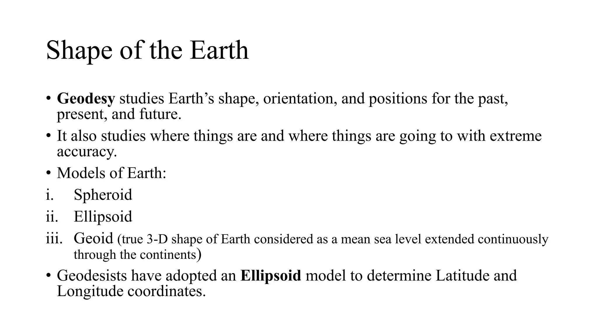
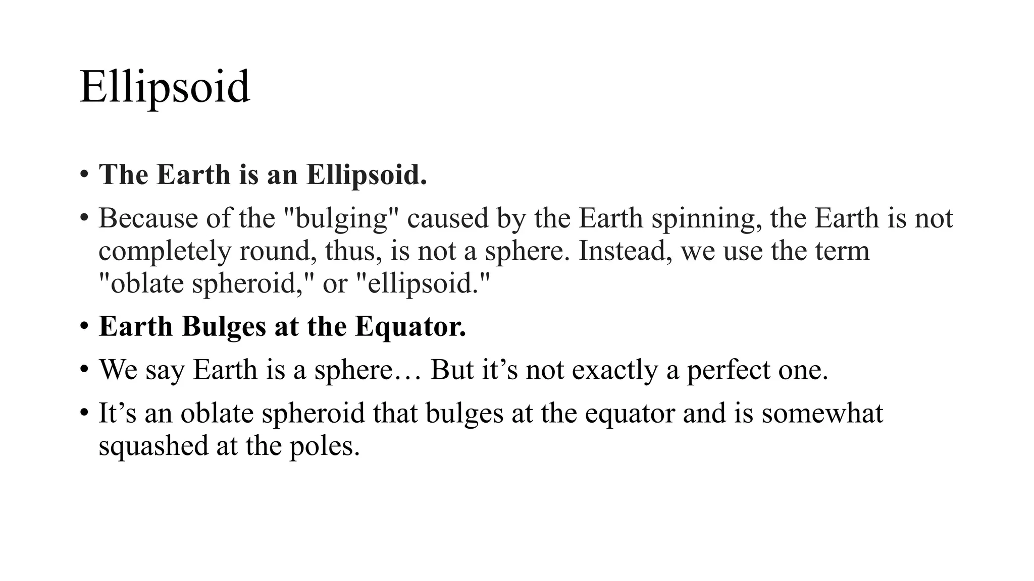
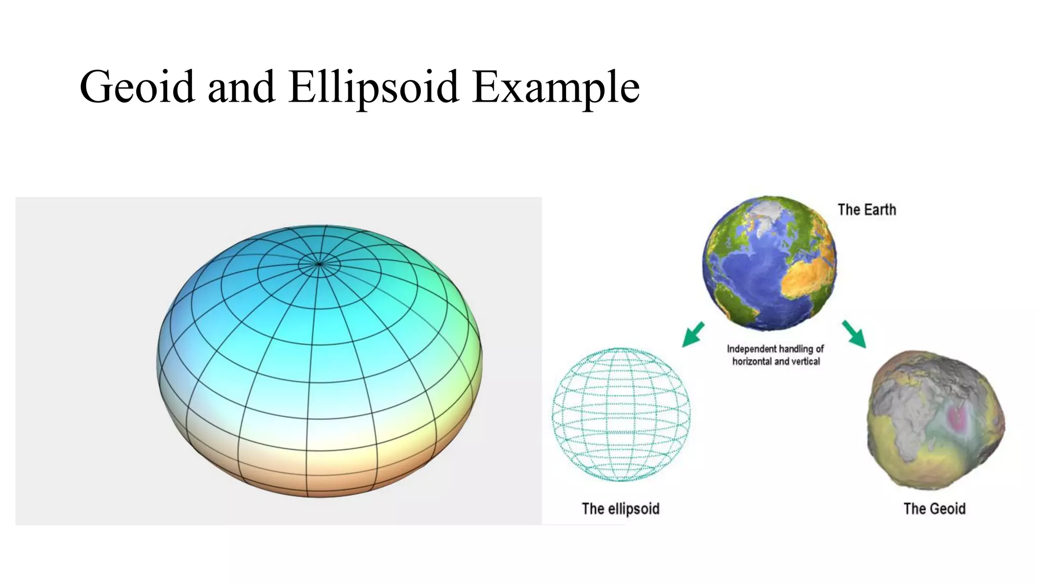
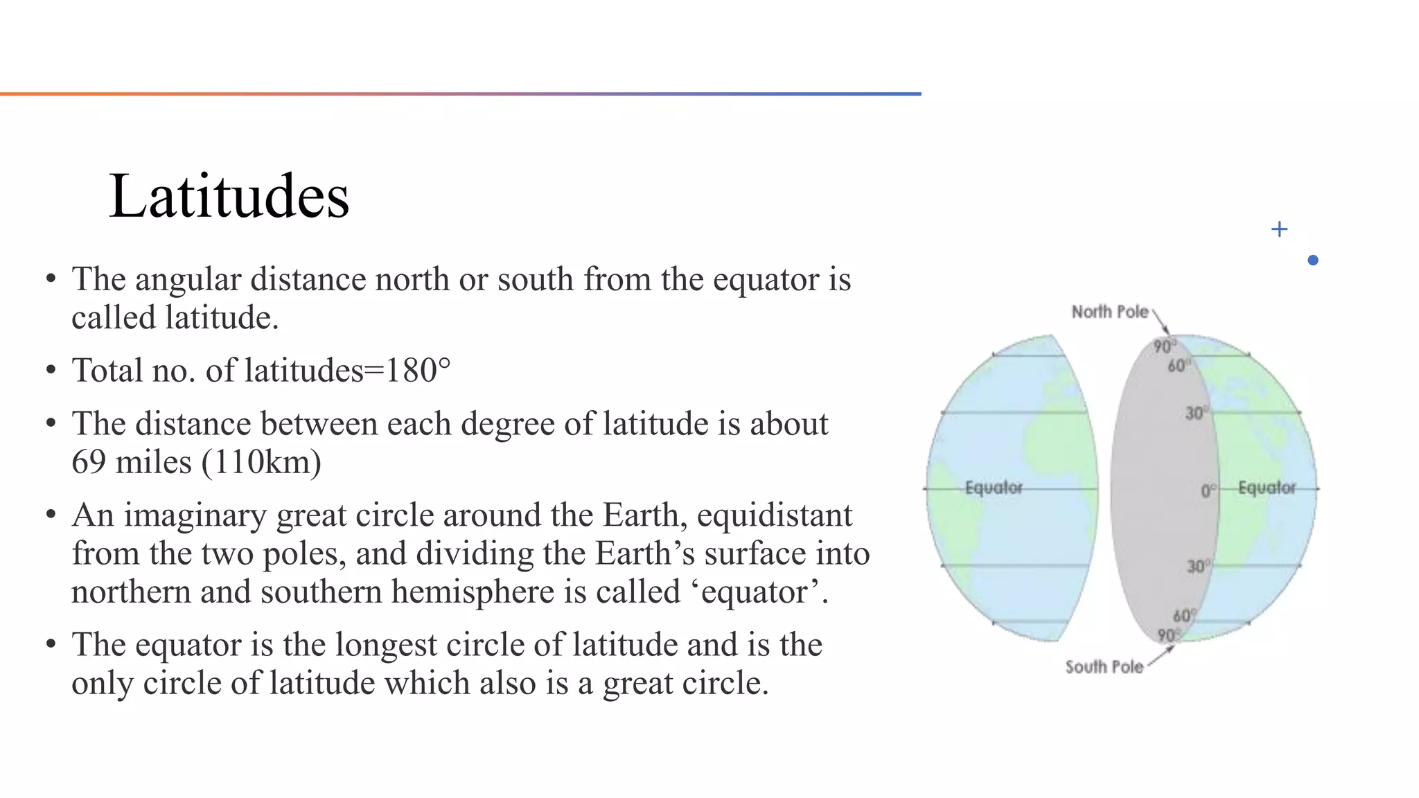
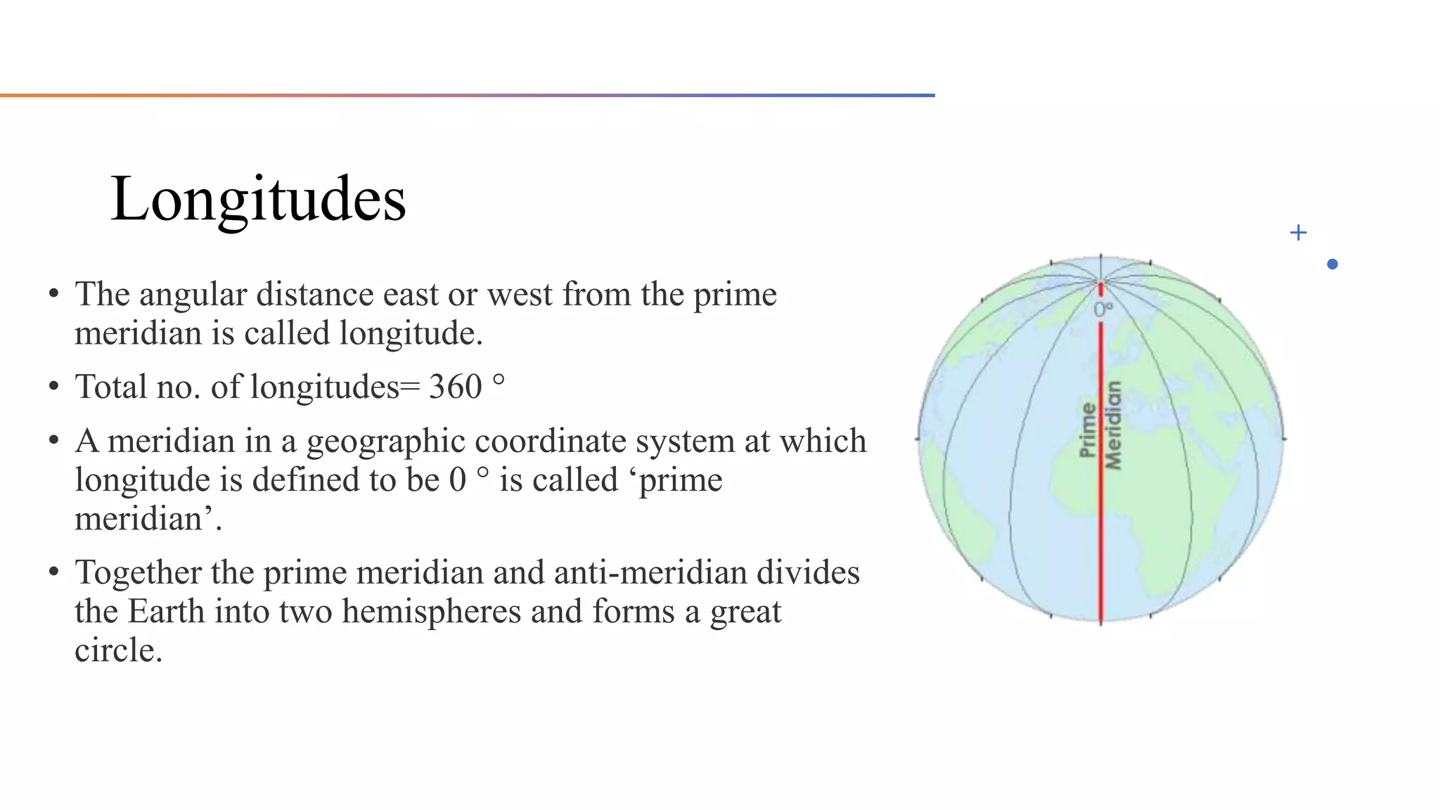
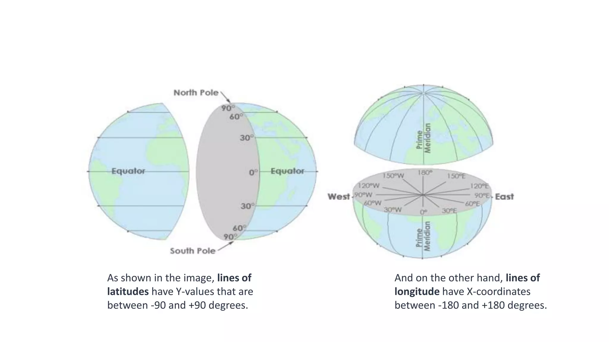
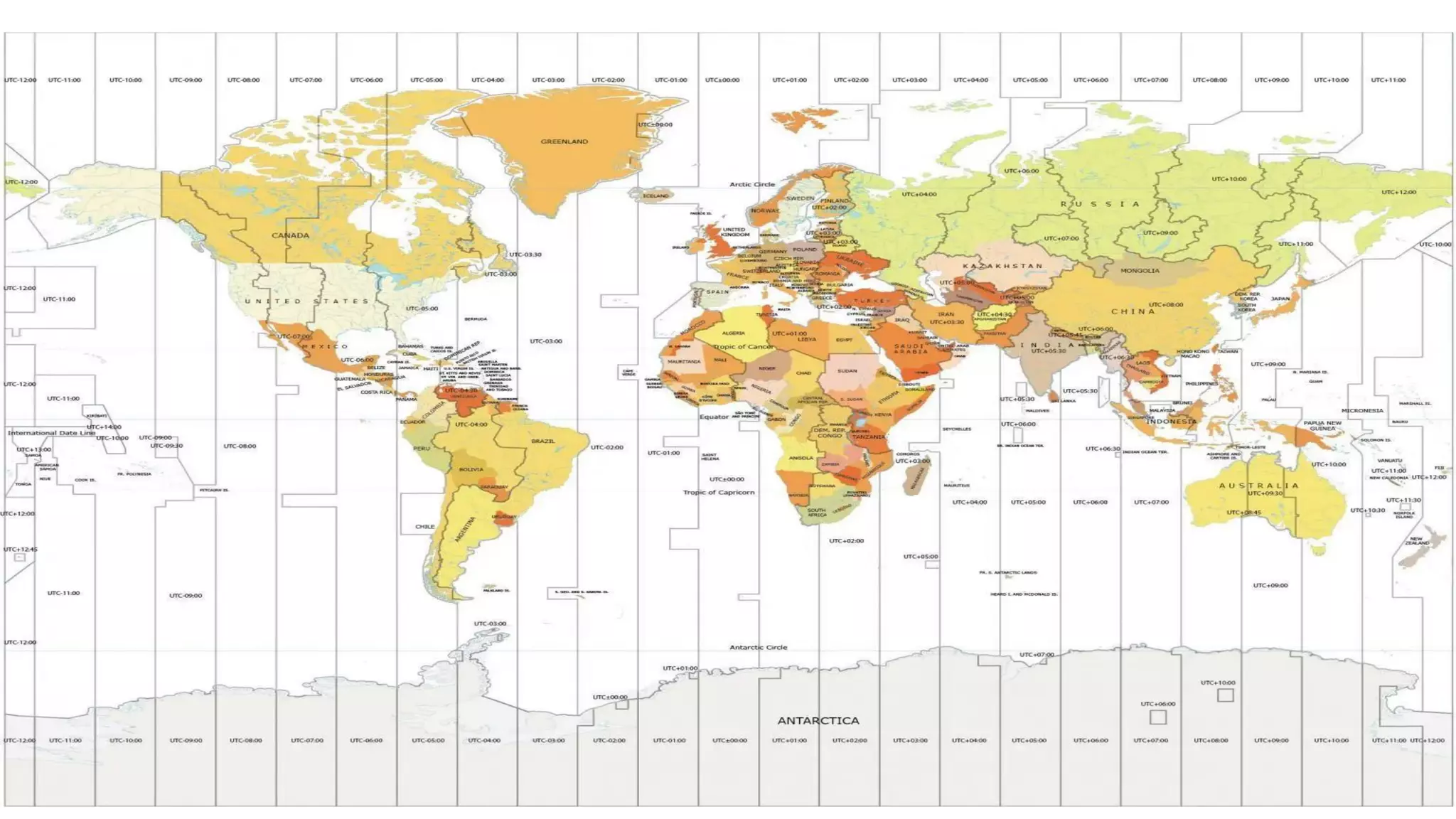
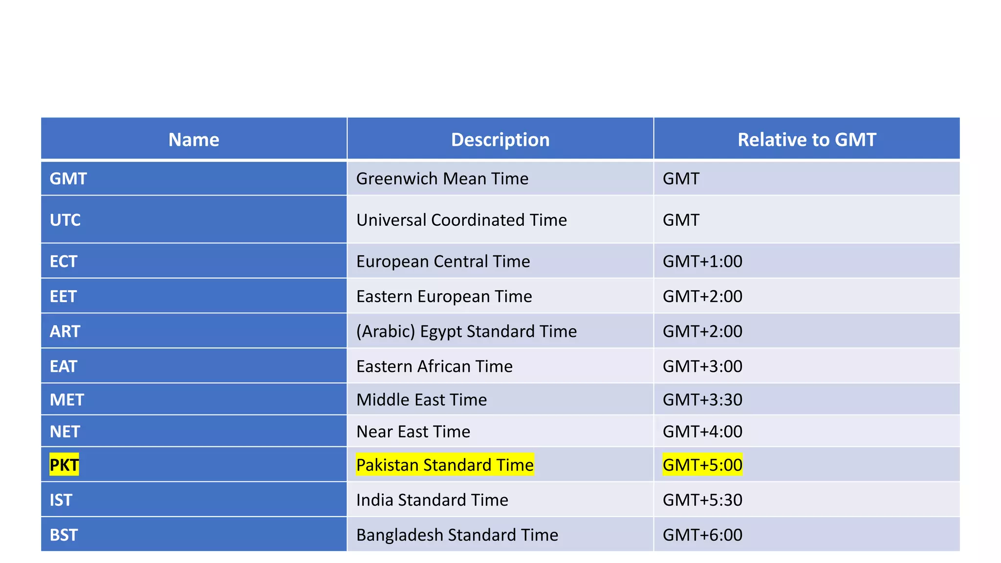
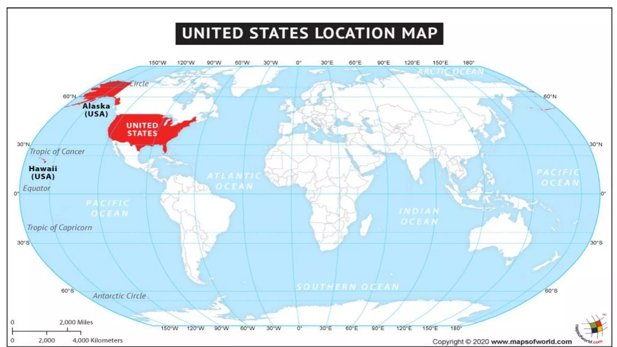
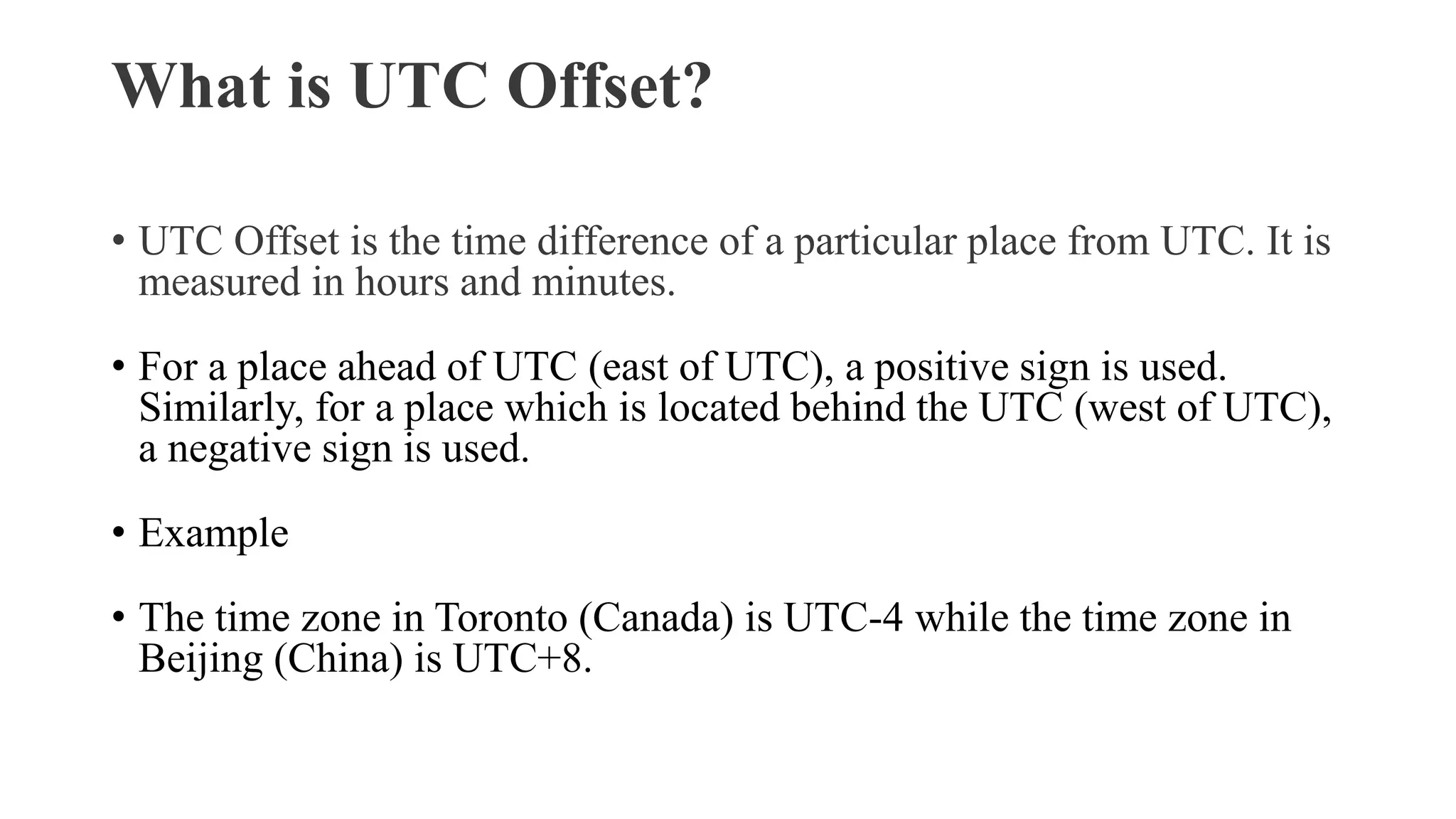
SlideShare a Scribd company logo
Geographic
Coordinate
System
By Mahnoor Bukhari
Shape of the Earth
• Geodesy studies Earth’s shape, orientation, and positions for the past,
present, and future.
• It also studies where things are and where things are going to with extreme
accuracy.
• Models of Earth:
i. Spheroid
ii. Ellipsoid
iii. Geoid (true 3-D shape of Earth considered as a mean sea level extended continuously
through the continents)
• Geodesists have adopted an Ellipsoid model to determine Latitude and
Longitude coordinates.
a figure resembling a sphere. also : an object of approximately spherical shape.
Ellipsoid
• The Earth is an Ellipsoid.
• Because of the "bulging" caused by the Earth spinning, the Earth is not
completely round, thus, is not a sphere. Instead, we use the term
"oblate spheroid," or "ellipsoid."
• Earth Bulges at the Equator.
• We say Earth is a sphere… But it’s not exactly a perfect one.
• It’s an oblate spheroid that bulges at the equator and is somewhat
squashed at the poles.
Geoid and Ellipsoid Example
Earth’s Geographical
Coordinates
• Latitude and longitude, together forms Earth’s
geographical coordinates, and represents the
angular distance of any location from the center of
the Earth.
• A grid of parallels and meridians shown as lines
on a map is called a ‘graticule’.
Latitudes
• Any circle that runs east and west around Earth and that is parallel to
the equator is called ‘parallel’ or a ‘line of latitude’.
• All parallels (lines of latitude) except equator get smaller as you get
near the pole.
• Parallel but not equal.
• Five Important Latitudes:
• Arctic circle -----------------→ 66 1/2° N
• Tropic of cancer -----------------→ 23 1/2° N
• Equator -----------------→ 0°
• Tropic of Capricorn -------------→ 23 1/2° S
• Antarctic circle -----------------→ 66 1/2° S
Longitudes
(earth)
• Any semi-circle that runs north and south around Earth from the
geographic north pole to geographic south pole is called ‘meridian’ or
‘line of longitude’.
• The distance between longitudes reaches zero at the poles as the lines
of meridian converge at that point.
• Not parallel but equal.
And on the other hand, lines of
longitude have X-coordinates
between -180 and +180 degrees.
As shown in the image, lines of
latitudes have Y-values that are
between -90 and +90 degrees.
Explanation of Coordinate System
• When you put two coordinates together as a pair (X, Y), you can locate anything on Earth.
• Latitude and longitude form our coordinate system grid.
• Thanks to our geographic coordinate, you can pinpoint any point on Earth such as GPS
receivers.
• Cartographers write latitudes and longitudes in degrees-minutes-seconds (DMS) and
decimal degrees. For degrees-minutes-seconds, minutes range from 0 to 60. For example, the
geographic coordinate expressed in degrees-minutes-seconds for New York City is:
• Latitude: 40 degrees, 42 minutes, 51 seconds N
• Longitude: 74 degrees, 0 minutes, 21 seconds W
• You can also express geographic coordinates in decimal degrees. It’s just another way to
represent that same location in a different format. For example, here is New York City in
decimal degrees:
• Latitude: 40.714 N
• Longitude: -74.006 W
GPS Coordinates Pakistan
• Pakistan lies in the North-East part of the world
• 23 degrees 35 minutes to 37 degrees 05 minutes North (latitude)
• 60 degrees 50 minutes to 77 degrees 50 minutes East (longitude)
World Time Zones
UTC vs. GMT: History
• You'll often see UTC (Coordinated Universal Time) and GMT (Greenwich Mean Time) used
interchangeably, and while doing so can be suitable for informal use, they are not technically the same.
• GMT, or Greenwich Mean Time, is a time zone located along the prime meridian. It was established as
an international standard in 1884 at the International Meridian Conference, where many nations got
together to decide what the prime meridian of the Earth would be. Prior to this, time varied wildly in
different areas.
• The prime meridian selected at that conference runs through the Royal Observatory in Greenwich,
giving the time zone its name. From 1884 until the 1950s, GMT was used as the time standard.
• However, as atomic clocks were invented in the 1950s, there were more accurate ways of keeping time.
The new standard for coordinated time was first used at the beginning of 1960, but it didn't become an
official term until 1967 and replaced GMT a few years later.
• So, GMT is a time zone, while UTC is a time standard. You can consider UTC the successor to GMT, as
it's more accurate.
UTC or Coordinated Universal Time
• What Is UTC?
• UTC is the standard of time used all around the world to regulate clocks. It is
effectively the "center" of our timekeeping, with all time zones referenced in relation to
how far ahead of, or far behind, UTC they are.
• The full name for UTC is Coordinated Universal Time, and its initialism was reached
as a compromise. English speakers wanted to use CUT (for "Coordinated Universal
Time"), while French speakers advocated for TUC (short for "temps universel
coordonné"). Ultimately, UTC was chosen.
Time Zones Explained
• What are the Time Zones?
• Time Zones are a geographical division of the terrestrial globe into 24
longitudinal sections. The distance between two consecutive time zones is
approximately 15°. Each such time zone observes a uniform standard time.
• We have 24 different time zones in the world. Because the Earth rotates
360° every 24 hours, each time zone is 15° longitude apart from the other.
(360÷24=15)
• The Prime Meridian (Greenwich Meridian) defines the center of the first
time zone in the world
Irregular Time Zone Boundaries
• No time zone in the world runs a perfect north-south line. Instead, they
are jagged and adapt to the political boundaries of countries. Also,
there can be “irregular square” time zones similar to islands.
Name Description Relative to GMT
GMT Greenwich Mean Time GMT
UTC Universal Coordinated Time GMT
ECT European Central Time GMT+1:00
EET Eastern European Time GMT+2:00
ART (Arabic) Egypt Standard Time GMT+2:00
EAT Eastern African Time GMT+3:00
MET Middle East Time GMT+3:30
NET Near East Time GMT+4:00
PKT Pakistan Standard Time GMT+5:00
IST India Standard Time GMT+5:30
BST Bangladesh Standard Time GMT+6:00
Why do countries need different time zones?
• Maintaining different time zones for any country is not an easy choice.
From commercial and business transactions to transportation and
communication, everything is dependent on time. Thus, most countries
of the world have opted for one standard time zone. Some countries,
with comparatively larger areas or territories scattered around the
world, do opt for multiple time zones. For example, the USA, Russia
and Canada have multiple time zones within the country.
What is UTC Offset?
• UTC Offset is the time difference of a particular place from UTC. It is
measured in hours and minutes.
• For a place ahead of UTC (east of UTC), a positive sign is used.
Similarly, for a place which is located behind the UTC (west of UTC),
a negative sign is used.
• Example
• The time zone in Toronto (Canada) is UTC-4 while the time zone in
Beijing (China) is UTC+8.
Pakistan Time Zone
• Pakistan Standard Time (abbreviated as PKT) is UTC+05:00 hours
ahead of Coordinated Universal Time.
International Date Line
• The International Date Line is a north-south line in the Pacific Ocean
where you turn your calendar back or ahead one day. The center of the
time zone roughly follows 180° longitude without crossing any
landmass.
• When you cross the International Date Line moving toward the east,
you turn your calendar back one day. Whereas when you go from the
west across the International Date Line, you turn your calendar ahead
one day.
Thanks.

More Related Content

What's hot

Geophysical Exploration
Geophysical ExplorationGeophysical Exploration
Geophysical Exploration
Sohail Nawab
 
Geological mapping
Geological mappingGeological mapping
Geological mapping
Pramoda Raj
 
The Earth, the Geographic Coordinates
The Earth, the Geographic CoordinatesThe Earth, the Geographic Coordinates
The Earth, the Geographic Coordinates
María Jesús Campos Fernández
 
Toposheet interpretation
Toposheet interpretationToposheet interpretation
Toposheet interpretation
Pramod Hanamgond
 
Reading Topographic Maps
Reading Topographic MapsReading Topographic Maps
Reading Topographic Mapsduncanpatti
 
Projection
ProjectionProjection
Projection
SUPARNA DEY
 
Landforms Relief
Landforms ReliefLandforms Relief
Landforms Relief
Carmen sb
 
Geochemistry
GeochemistryGeochemistry
Geochemistry
Shah Naseer
 
Salt Range Field Report
Salt Range Field ReportSalt Range Field Report
Salt Range Field Report
AHMAD GHANI
 
Day 1 in khewra gorge
Day 1 in khewra gorgeDay 1 in khewra gorge
Day 1 in khewra gorge
kashif008
 
Map Parts
Map PartsMap Parts
Map Parts
maggiedesmond
 
Vertical Exaggeration
Vertical ExaggerationVertical Exaggeration
Vertical Exaggeration
Rob Marchetto
 
geodesy-1 (1).pptx
geodesy-1 (1).pptxgeodesy-1 (1).pptx
geodesy-1 (1).pptx
DrOmegaYT
 
Gravity method
Gravity methodGravity method
Gravity method
Amin khalil
 
Coordinate systems
Coordinate systemsCoordinate systems
Coordinate systems
Saad Raja
 
Origin of ocean basins
Origin of ocean basinsOrigin of ocean basins
Origin of ocean basins
Prof. A.Balasubramanian
 
Geological Map.ppt
Geological Map.pptGeological Map.ppt
Geological Map.ppt
Kalpajyoti Mazumdar
 

What's hot (20)

Geophysical Exploration
Geophysical ExplorationGeophysical Exploration
Geophysical Exploration
 
Geological mapping
Geological mappingGeological mapping
Geological mapping
 
The Earth, the Geographic Coordinates
The Earth, the Geographic CoordinatesThe Earth, the Geographic Coordinates
The Earth, the Geographic Coordinates
 
Toposheet interpretation
Toposheet interpretationToposheet interpretation
Toposheet interpretation
 
Reading Topographic Maps
Reading Topographic MapsReading Topographic Maps
Reading Topographic Maps
 
Chap 4
Chap 4Chap 4
Chap 4
 
Projection
ProjectionProjection
Projection
 
Landforms Relief
Landforms ReliefLandforms Relief
Landforms Relief
 
Geochemistry
GeochemistryGeochemistry
Geochemistry
 
Salt Range Field Report
Salt Range Field ReportSalt Range Field Report
Salt Range Field Report
 
Topographic Maps Notes
Topographic Maps NotesTopographic Maps Notes
Topographic Maps Notes
 
Day 1 in khewra gorge
Day 1 in khewra gorgeDay 1 in khewra gorge
Day 1 in khewra gorge
 
Map Parts
Map PartsMap Parts
Map Parts
 
Vertical Exaggeration
Vertical ExaggerationVertical Exaggeration
Vertical Exaggeration
 
geodesy-1 (1).pptx
geodesy-1 (1).pptxgeodesy-1 (1).pptx
geodesy-1 (1).pptx
 
Gravity method
Gravity methodGravity method
Gravity method
 
Coordinate systems
Coordinate systemsCoordinate systems
Coordinate systems
 
Origin of ocean basins
Origin of ocean basinsOrigin of ocean basins
Origin of ocean basins
 
Geological Map.ppt
Geological Map.pptGeological Map.ppt
Geological Map.ppt
 
Topographic Maps
Topographic MapsTopographic Maps
Topographic Maps
 

Similar to Geographic Coordinate System.pdf

Role of Geography in Tourism
Role of Geography in TourismRole of Geography in Tourism
Role of Geography in Tourism
RaviSheoran7
 
Geography five lab one
Geography five lab oneGeography five lab one
Geography five lab onelschmidt1170
 
Geography five lab one
Geography five lab oneGeography five lab one
Geography five lab onelschmidt1170
 
Lab two location and time
Lab two location and timeLab two location and time
Lab two location and timeLisa Schmidt
 
Travel Agency and Tour Operation Management -Geography of Tourism
Travel Agency and Tour Operation Management -Geography of TourismTravel Agency and Tour Operation Management -Geography of Tourism
Travel Agency and Tour Operation Management -Geography of Tourism
Nataraja T.C
 
QUICK GEOGRAPHY (1).pdf
QUICK GEOGRAPHY (1).pdfQUICK GEOGRAPHY (1).pdf
QUICK GEOGRAPHY (1).pdf
shailendrasinghbhado4
 
Geographic grid latitudes and longitudes made by Ravi Bharti
Geographic grid  latitudes and longitudes made by Ravi BhartiGeographic grid  latitudes and longitudes made by Ravi Bharti
Geographic grid latitudes and longitudes made by Ravi Bharti
RaviBharti18
 
3 lengte en breetelyne
3 lengte en breetelyne3 lengte en breetelyne
3 lengte en breetelyne
Vickey De Jager
 
UNDERSTANDING TIME & DATE MERIDIAN
UNDERSTANDING TIME & DATE MERIDIANUNDERSTANDING TIME & DATE MERIDIAN
UNDERSTANDING TIME & DATE MERIDIAN
Himadri Samal
 
FINAL globe latitudes and longitudes (1).pptx
FINAL globe  latitudes and longitudes (1).pptxFINAL globe  latitudes and longitudes (1).pptx
FINAL globe latitudes and longitudes (1).pptx
ChhayaRajeev
 
earth living planet.pptx
earth living planet.pptxearth living planet.pptx
earth living planet.pptx
MVHerwadkarschool
 
lat_and_lon_poewrpoint1_teacher_copy.ppt
lat_and_lon_poewrpoint1_teacher_copy.pptlat_and_lon_poewrpoint1_teacher_copy.ppt
lat_and_lon_poewrpoint1_teacher_copy.ppt
ASShyamkumar4792
 
6 latitude an longitude ..pptx
6 latitude an longitude   ..pptx6 latitude an longitude   ..pptx
6 latitude an longitude ..pptx
SwatiMaheshwari34
 
9. Time
9. Time9. Time
9. Time
AmenBAL
 
Time zones and international date line (idl
Time zones and international date line (idlTime zones and international date line (idl
Time zones and international date line (idlMuhammad Sajjad
 
4 atlas en kaartskale
4 atlas en kaartskale4 atlas en kaartskale
4 atlas en kaartskale
Vickey De Jager
 
GLOBE.pdf
GLOBE.pdfGLOBE.pdf
GLOBE.pdf
Manpreet Kaur
 

Similar to Geographic Coordinate System.pdf (20)

Role of Geography in Tourism
Role of Geography in TourismRole of Geography in Tourism
Role of Geography in Tourism
 
Time zones
Time zonesTime zones
Time zones
 
Geography five lab one
Geography five lab oneGeography five lab one
Geography five lab one
 
Geography five lab one
Geography five lab oneGeography five lab one
Geography five lab one
 
Lab two location and time
Lab two location and timeLab two location and time
Lab two location and time
 
Travel Agency and Tour Operation Management -Geography of Tourism
Travel Agency and Tour Operation Management -Geography of TourismTravel Agency and Tour Operation Management -Geography of Tourism
Travel Agency and Tour Operation Management -Geography of Tourism
 
QUICK GEOGRAPHY (1).pdf
QUICK GEOGRAPHY (1).pdfQUICK GEOGRAPHY (1).pdf
QUICK GEOGRAPHY (1).pdf
 
Geographic grid latitudes and longitudes made by Ravi Bharti
Geographic grid  latitudes and longitudes made by Ravi BhartiGeographic grid  latitudes and longitudes made by Ravi Bharti
Geographic grid latitudes and longitudes made by Ravi Bharti
 
3 lengte en breetelyne
3 lengte en breetelyne3 lengte en breetelyne
3 lengte en breetelyne
 
UNDERSTANDING TIME & DATE MERIDIAN
UNDERSTANDING TIME & DATE MERIDIANUNDERSTANDING TIME & DATE MERIDIAN
UNDERSTANDING TIME & DATE MERIDIAN
 
FINAL globe latitudes and longitudes (1).pptx
FINAL globe  latitudes and longitudes (1).pptxFINAL globe  latitudes and longitudes (1).pptx
FINAL globe latitudes and longitudes (1).pptx
 
earth living planet.pptx
earth living planet.pptxearth living planet.pptx
earth living planet.pptx
 
lat_and_lon_poewrpoint1_teacher_copy.ppt
lat_and_lon_poewrpoint1_teacher_copy.pptlat_and_lon_poewrpoint1_teacher_copy.ppt
lat_and_lon_poewrpoint1_teacher_copy.ppt
 
6 latitude an longitude ..pptx
6 latitude an longitude   ..pptx6 latitude an longitude   ..pptx
6 latitude an longitude ..pptx
 
9. Time
9. Time9. Time
9. Time
 
Time zones and international date line (idl
Time zones and international date line (idlTime zones and international date line (idl
Time zones and international date line (idl
 
Location and time
Location and timeLocation and time
Location and time
 
4 atlas en kaartskale
4 atlas en kaartskale4 atlas en kaartskale
4 atlas en kaartskale
 
Planet earth
Planet earthPlanet earth
Planet earth
 
GLOBE.pdf
GLOBE.pdfGLOBE.pdf
GLOBE.pdf
 

Recently uploaded

PIMS Job Advertisement 2024.pdf Islamabad
PIMS Job Advertisement 2024.pdf IslamabadPIMS Job Advertisement 2024.pdf Islamabad
PIMS Job Advertisement 2024.pdf Islamabad
AyyanKhan40
 
2024.06.01 Introducing a competency framework for languag learning materials ...
2024.06.01 Introducing a competency framework for languag learning materials ...2024.06.01 Introducing a competency framework for languag learning materials ...
2024.06.01 Introducing a competency framework for languag learning materials ...
Sandy Millin
 
Mule 4.6 & Java 17 Upgrade | MuleSoft Mysore Meetup #46
Mule 4.6 & Java 17 Upgrade | MuleSoft Mysore Meetup #46Mule 4.6 & Java 17 Upgrade | MuleSoft Mysore Meetup #46
Mule 4.6 & Java 17 Upgrade | MuleSoft Mysore Meetup #46
MysoreMuleSoftMeetup
 
Acetabularia Information For Class 9 .docx
Acetabularia Information For Class 9  .docxAcetabularia Information For Class 9  .docx
Acetabularia Information For Class 9 .docx
vaibhavrinwa19
 
Assignment_4_ArianaBusciglio Marvel(1).docx
Assignment_4_ArianaBusciglio Marvel(1).docxAssignment_4_ArianaBusciglio Marvel(1).docx
Assignment_4_ArianaBusciglio Marvel(1).docx
ArianaBusciglio
 
How to Add Chatter in the odoo 17 ERP Module
How to Add Chatter in the odoo 17 ERP ModuleHow to Add Chatter in the odoo 17 ERP Module
How to Add Chatter in the odoo 17 ERP Module
Celine George
 
S1-Introduction-Biopesticides in ICM.pptx
S1-Introduction-Biopesticides in ICM.pptxS1-Introduction-Biopesticides in ICM.pptx
S1-Introduction-Biopesticides in ICM.pptx
tarandeep35
 
Aficamten in HCM (SEQUOIA HCM TRIAL 2024)
Aficamten in HCM (SEQUOIA HCM TRIAL 2024)Aficamten in HCM (SEQUOIA HCM TRIAL 2024)
Aficamten in HCM (SEQUOIA HCM TRIAL 2024)
Ashish Kohli
 
Lapbook sobre os Regimes Totalitários.pdf
Lapbook sobre os Regimes Totalitários.pdfLapbook sobre os Regimes Totalitários.pdf
Lapbook sobre os Regimes Totalitários.pdf
Jean Carlos Nunes Paixão
 
Thesis Statement for students diagnonsed withADHD.ppt
Thesis Statement for students diagnonsed withADHD.pptThesis Statement for students diagnonsed withADHD.ppt
Thesis Statement for students diagnonsed withADHD.ppt
EverAndrsGuerraGuerr
 
Delivering Micro-Credentials in Technical and Vocational Education and Training
Delivering Micro-Credentials in Technical and Vocational Education and TrainingDelivering Micro-Credentials in Technical and Vocational Education and Training
Delivering Micro-Credentials in Technical and Vocational Education and Training
AG2 Design
 
Chapter 4 - Islamic Financial Institutions in Malaysia.pptx
Chapter 4 - Islamic Financial Institutions in Malaysia.pptxChapter 4 - Islamic Financial Institutions in Malaysia.pptx
Chapter 4 - Islamic Financial Institutions in Malaysia.pptx
Mohd Adib Abd Muin, Senior Lecturer at Universiti Utara Malaysia
 
World environment day ppt For 5 June 2024
World environment day ppt For 5 June 2024World environment day ppt For 5 June 2024
World environment day ppt For 5 June 2024
ak6969907
 
Biological Screening of Herbal Drugs in detailed.
Biological Screening of Herbal Drugs in detailed.Biological Screening of Herbal Drugs in detailed.
Biological Screening of Herbal Drugs in detailed.
Ashokrao Mane college of Pharmacy Peth-Vadgaon
 
DRUGS AND ITS classification slide share
DRUGS AND ITS classification slide shareDRUGS AND ITS classification slide share
DRUGS AND ITS classification slide share
taiba qazi
 
Introduction to AI for Nonprofits with Tapp Network
Introduction to AI for Nonprofits with Tapp NetworkIntroduction to AI for Nonprofits with Tapp Network
Introduction to AI for Nonprofits with Tapp Network
TechSoup
 
Exploiting Artificial Intelligence for Empowering Researchers and Faculty, In...
Exploiting Artificial Intelligence for Empowering Researchers and Faculty, In...Exploiting Artificial Intelligence for Empowering Researchers and Faculty, In...
Exploiting Artificial Intelligence for Empowering Researchers and Faculty, In...
Dr. Vinod Kumar Kanvaria
 
BÀI TẬP BỔ TRỢ TIẾNG ANH GLOBAL SUCCESS LỚP 3 - CẢ NĂM (CÓ FILE NGHE VÀ ĐÁP Á...
BÀI TẬP BỔ TRỢ TIẾNG ANH GLOBAL SUCCESS LỚP 3 - CẢ NĂM (CÓ FILE NGHE VÀ ĐÁP Á...BÀI TẬP BỔ TRỢ TIẾNG ANH GLOBAL SUCCESS LỚP 3 - CẢ NĂM (CÓ FILE NGHE VÀ ĐÁP Á...
BÀI TẬP BỔ TRỢ TIẾNG ANH GLOBAL SUCCESS LỚP 3 - CẢ NĂM (CÓ FILE NGHE VÀ ĐÁP Á...
Nguyen Thanh Tu Collection
 
A Strategic Approach: GenAI in Education
A Strategic Approach: GenAI in EducationA Strategic Approach: GenAI in Education
A Strategic Approach: GenAI in Education
Peter Windle
 
Best Digital Marketing Institute In NOIDA
Best Digital Marketing Institute In NOIDABest Digital Marketing Institute In NOIDA
Best Digital Marketing Institute In NOIDA
deeptiverma2406
 

Recently uploaded (20)

PIMS Job Advertisement 2024.pdf Islamabad
PIMS Job Advertisement 2024.pdf IslamabadPIMS Job Advertisement 2024.pdf Islamabad
PIMS Job Advertisement 2024.pdf Islamabad
 
2024.06.01 Introducing a competency framework for languag learning materials ...
2024.06.01 Introducing a competency framework for languag learning materials ...2024.06.01 Introducing a competency framework for languag learning materials ...
2024.06.01 Introducing a competency framework for languag learning materials ...
 
Mule 4.6 & Java 17 Upgrade | MuleSoft Mysore Meetup #46
Mule 4.6 & Java 17 Upgrade | MuleSoft Mysore Meetup #46Mule 4.6 & Java 17 Upgrade | MuleSoft Mysore Meetup #46
Mule 4.6 & Java 17 Upgrade | MuleSoft Mysore Meetup #46
 
Acetabularia Information For Class 9 .docx
Acetabularia Information For Class 9  .docxAcetabularia Information For Class 9  .docx
Acetabularia Information For Class 9 .docx
 
Assignment_4_ArianaBusciglio Marvel(1).docx
Assignment_4_ArianaBusciglio Marvel(1).docxAssignment_4_ArianaBusciglio Marvel(1).docx
Assignment_4_ArianaBusciglio Marvel(1).docx
 
How to Add Chatter in the odoo 17 ERP Module
How to Add Chatter in the odoo 17 ERP ModuleHow to Add Chatter in the odoo 17 ERP Module
How to Add Chatter in the odoo 17 ERP Module
 
S1-Introduction-Biopesticides in ICM.pptx
S1-Introduction-Biopesticides in ICM.pptxS1-Introduction-Biopesticides in ICM.pptx
S1-Introduction-Biopesticides in ICM.pptx
 
Aficamten in HCM (SEQUOIA HCM TRIAL 2024)
Aficamten in HCM (SEQUOIA HCM TRIAL 2024)Aficamten in HCM (SEQUOIA HCM TRIAL 2024)
Aficamten in HCM (SEQUOIA HCM TRIAL 2024)
 
Lapbook sobre os Regimes Totalitários.pdf
Lapbook sobre os Regimes Totalitários.pdfLapbook sobre os Regimes Totalitários.pdf
Lapbook sobre os Regimes Totalitários.pdf
 
Thesis Statement for students diagnonsed withADHD.ppt
Thesis Statement for students diagnonsed withADHD.pptThesis Statement for students diagnonsed withADHD.ppt
Thesis Statement for students diagnonsed withADHD.ppt
 
Delivering Micro-Credentials in Technical and Vocational Education and Training
Delivering Micro-Credentials in Technical and Vocational Education and TrainingDelivering Micro-Credentials in Technical and Vocational Education and Training
Delivering Micro-Credentials in Technical and Vocational Education and Training
 
Chapter 4 - Islamic Financial Institutions in Malaysia.pptx
Chapter 4 - Islamic Financial Institutions in Malaysia.pptxChapter 4 - Islamic Financial Institutions in Malaysia.pptx
Chapter 4 - Islamic Financial Institutions in Malaysia.pptx
 
World environment day ppt For 5 June 2024
World environment day ppt For 5 June 2024World environment day ppt For 5 June 2024
World environment day ppt For 5 June 2024
 
Biological Screening of Herbal Drugs in detailed.
Biological Screening of Herbal Drugs in detailed.Biological Screening of Herbal Drugs in detailed.
Biological Screening of Herbal Drugs in detailed.
 
DRUGS AND ITS classification slide share
DRUGS AND ITS classification slide shareDRUGS AND ITS classification slide share
DRUGS AND ITS classification slide share
 
Introduction to AI for Nonprofits with Tapp Network
Introduction to AI for Nonprofits with Tapp NetworkIntroduction to AI for Nonprofits with Tapp Network
Introduction to AI for Nonprofits with Tapp Network
 
Exploiting Artificial Intelligence for Empowering Researchers and Faculty, In...
Exploiting Artificial Intelligence for Empowering Researchers and Faculty, In...Exploiting Artificial Intelligence for Empowering Researchers and Faculty, In...
Exploiting Artificial Intelligence for Empowering Researchers and Faculty, In...
 
BÀI TẬP BỔ TRỢ TIẾNG ANH GLOBAL SUCCESS LỚP 3 - CẢ NĂM (CÓ FILE NGHE VÀ ĐÁP Á...
BÀI TẬP BỔ TRỢ TIẾNG ANH GLOBAL SUCCESS LỚP 3 - CẢ NĂM (CÓ FILE NGHE VÀ ĐÁP Á...BÀI TẬP BỔ TRỢ TIẾNG ANH GLOBAL SUCCESS LỚP 3 - CẢ NĂM (CÓ FILE NGHE VÀ ĐÁP Á...
BÀI TẬP BỔ TRỢ TIẾNG ANH GLOBAL SUCCESS LỚP 3 - CẢ NĂM (CÓ FILE NGHE VÀ ĐÁP Á...
 
A Strategic Approach: GenAI in Education
A Strategic Approach: GenAI in EducationA Strategic Approach: GenAI in Education
A Strategic Approach: GenAI in Education
 
Best Digital Marketing Institute In NOIDA
Best Digital Marketing Institute In NOIDABest Digital Marketing Institute In NOIDA
Best Digital Marketing Institute In NOIDA
 

Geographic Coordinate System.pdf

  • 2. Shape of the Earth • Geodesy studies Earth’s shape, orientation, and positions for the past, present, and future. • It also studies where things are and where things are going to with extreme accuracy. • Models of Earth: i. Spheroid ii. Ellipsoid iii. Geoid (true 3-D shape of Earth considered as a mean sea level extended continuously through the continents) • Geodesists have adopted an Ellipsoid model to determine Latitude and Longitude coordinates. a figure resembling a sphere. also : an object of approximately spherical shape.
  • 3. Ellipsoid • The Earth is an Ellipsoid. • Because of the "bulging" caused by the Earth spinning, the Earth is not completely round, thus, is not a sphere. Instead, we use the term "oblate spheroid," or "ellipsoid." • Earth Bulges at the Equator. • We say Earth is a sphere… But it’s not exactly a perfect one. • It’s an oblate spheroid that bulges at the equator and is somewhat squashed at the poles.
  • 5. Earth’s Geographical Coordinates • Latitude and longitude, together forms Earth’s geographical coordinates, and represents the angular distance of any location from the center of the Earth. • A grid of parallels and meridians shown as lines on a map is called a ‘graticule’.
  • 7. • Any circle that runs east and west around Earth and that is parallel to the equator is called ‘parallel’ or a ‘line of latitude’. • All parallels (lines of latitude) except equator get smaller as you get near the pole. • Parallel but not equal. • Five Important Latitudes: • Arctic circle -----------------→ 66 1/2° N • Tropic of cancer -----------------→ 23 1/2° N • Equator -----------------→ 0° • Tropic of Capricorn -------------→ 23 1/2° S • Antarctic circle -----------------→ 66 1/2° S
  • 9. • Any semi-circle that runs north and south around Earth from the geographic north pole to geographic south pole is called ‘meridian’ or ‘line of longitude’. • The distance between longitudes reaches zero at the poles as the lines of meridian converge at that point. • Not parallel but equal.
  • 10. And on the other hand, lines of longitude have X-coordinates between -180 and +180 degrees. As shown in the image, lines of latitudes have Y-values that are between -90 and +90 degrees.
  • 11. Explanation of Coordinate System • When you put two coordinates together as a pair (X, Y), you can locate anything on Earth. • Latitude and longitude form our coordinate system grid. • Thanks to our geographic coordinate, you can pinpoint any point on Earth such as GPS receivers. • Cartographers write latitudes and longitudes in degrees-minutes-seconds (DMS) and decimal degrees. For degrees-minutes-seconds, minutes range from 0 to 60. For example, the geographic coordinate expressed in degrees-minutes-seconds for New York City is: • Latitude: 40 degrees, 42 minutes, 51 seconds N • Longitude: 74 degrees, 0 minutes, 21 seconds W • You can also express geographic coordinates in decimal degrees. It’s just another way to represent that same location in a different format. For example, here is New York City in decimal degrees: • Latitude: 40.714 N • Longitude: -74.006 W
  • 12. GPS Coordinates Pakistan • Pakistan lies in the North-East part of the world • 23 degrees 35 minutes to 37 degrees 05 minutes North (latitude) • 60 degrees 50 minutes to 77 degrees 50 minutes East (longitude)
  • 14. UTC vs. GMT: History • You'll often see UTC (Coordinated Universal Time) and GMT (Greenwich Mean Time) used interchangeably, and while doing so can be suitable for informal use, they are not technically the same. • GMT, or Greenwich Mean Time, is a time zone located along the prime meridian. It was established as an international standard in 1884 at the International Meridian Conference, where many nations got together to decide what the prime meridian of the Earth would be. Prior to this, time varied wildly in different areas. • The prime meridian selected at that conference runs through the Royal Observatory in Greenwich, giving the time zone its name. From 1884 until the 1950s, GMT was used as the time standard. • However, as atomic clocks were invented in the 1950s, there were more accurate ways of keeping time. The new standard for coordinated time was first used at the beginning of 1960, but it didn't become an official term until 1967 and replaced GMT a few years later. • So, GMT is a time zone, while UTC is a time standard. You can consider UTC the successor to GMT, as it's more accurate.
  • 15. UTC or Coordinated Universal Time • What Is UTC? • UTC is the standard of time used all around the world to regulate clocks. It is effectively the "center" of our timekeeping, with all time zones referenced in relation to how far ahead of, or far behind, UTC they are. • The full name for UTC is Coordinated Universal Time, and its initialism was reached as a compromise. English speakers wanted to use CUT (for "Coordinated Universal Time"), while French speakers advocated for TUC (short for "temps universel coordonné"). Ultimately, UTC was chosen.
  • 16. Time Zones Explained • What are the Time Zones? • Time Zones are a geographical division of the terrestrial globe into 24 longitudinal sections. The distance between two consecutive time zones is approximately 15°. Each such time zone observes a uniform standard time. • We have 24 different time zones in the world. Because the Earth rotates 360° every 24 hours, each time zone is 15° longitude apart from the other. (360÷24=15) • The Prime Meridian (Greenwich Meridian) defines the center of the first time zone in the world
  • 17. Irregular Time Zone Boundaries • No time zone in the world runs a perfect north-south line. Instead, they are jagged and adapt to the political boundaries of countries. Also, there can be “irregular square” time zones similar to islands.
  • 18.
  • 19. Name Description Relative to GMT GMT Greenwich Mean Time GMT UTC Universal Coordinated Time GMT ECT European Central Time GMT+1:00 EET Eastern European Time GMT+2:00 ART (Arabic) Egypt Standard Time GMT+2:00 EAT Eastern African Time GMT+3:00 MET Middle East Time GMT+3:30 NET Near East Time GMT+4:00 PKT Pakistan Standard Time GMT+5:00 IST India Standard Time GMT+5:30 BST Bangladesh Standard Time GMT+6:00
  • 20. Why do countries need different time zones? • Maintaining different time zones for any country is not an easy choice. From commercial and business transactions to transportation and communication, everything is dependent on time. Thus, most countries of the world have opted for one standard time zone. Some countries, with comparatively larger areas or territories scattered around the world, do opt for multiple time zones. For example, the USA, Russia and Canada have multiple time zones within the country.
  • 21.
  • 22. What is UTC Offset? • UTC Offset is the time difference of a particular place from UTC. It is measured in hours and minutes. • For a place ahead of UTC (east of UTC), a positive sign is used. Similarly, for a place which is located behind the UTC (west of UTC), a negative sign is used. • Example • The time zone in Toronto (Canada) is UTC-4 while the time zone in Beijing (China) is UTC+8.
  • 23. Pakistan Time Zone • Pakistan Standard Time (abbreviated as PKT) is UTC+05:00 hours ahead of Coordinated Universal Time.
  • 24. International Date Line • The International Date Line is a north-south line in the Pacific Ocean where you turn your calendar back or ahead one day. The center of the time zone roughly follows 180° longitude without crossing any landmass. • When you cross the International Date Line moving toward the east, you turn your calendar back one day. Whereas when you go from the west across the International Date Line, you turn your calendar ahead one day.