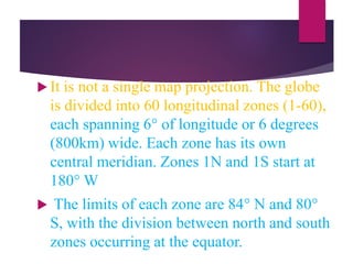
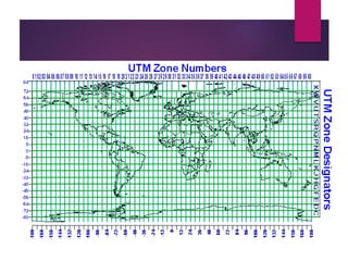
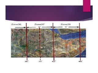
This document discusses coordinate systems and map projections. It defines projection as representing the curved Earth on a flat surface, which inevitably causes distortions. It describes geographic and projection coordinate systems, and how Universal Transverse Mercator (UTM) divides the world into zones to allow for linear measurements. Datums define precise starting points for coordinate systems and projections.
3. Projection: the method by which the curved 3-D
surface of the earth is represented by X,Y
coordinates on a 2-D flat map/screen. Distortion is
inevitable
Coordinate system
A coordinate system is a method of defining how a
file’s point locations display on a map. Different
types of coordinate systems exist that control how
the coordinates are shown on the map. The two
main are:
4. Geographic Coordinate System
use of Geographic latitude and longitude
system, usually in Degree, Minutes and
Seconds (DMS)
Use spherical coordinates to specify locations
on the surface of the earth
When vertical locations (Elevation) are not
concerned, Latitude/longitude pair are used
Geographic coordinate systems are commonly
called un projected lat/long
7. Projection: the method by which the
curved 3-D surface of the earth is
represented by X,Y coordinates on a 2-D
flat map/screen.
use of a known projection and datum.
Linear cords (metres) are required in
many occasions
Distortions are inevitable with
projection
8. Projections Preserve Some
Earth Properties
►Area - correct earth surface area (Albers
Equal Area) important for mass balances
►Shape - local angles are shown correctly
(Lambert Conformal Conic)
►Direction - all directions are shown
correctly relative to the center (Lambert
Azimuthal Equal Area)
►Distance - preserved along particular lines
►Some projections preserve two properties
9. General rules for selecting a
projection
Tropical Country—cylindrical
projection
Temperate Country—conical
projection
Polar Regions—Azimuthal
projection
10.
11.
12.
13.
14. UTM and UTM Zones
Universal Transverse Mercator
(UTM) System
Developed in the late 1940s by the US
Army
the projection is the ‘Gauss-Kruger’
version of the Transverse Mercator-
equidistant cylindrical projection
15. Intended for mapping areas : 840N – 800S
Unit of measure is meter
The world is divided into 60 zones of 60
of longitude in width (Fig. 2-4)
Zone 1 starts at 1800 W and Each zone has
its own coordinate system
Universal Transverse Mercator (UTM)
system is a specialized application of the
Transverse Mercator projection.
16. It is not a single map projection. The globe
is divided into 60 longitudinal zones (1-60),
each spanning 6° of longitude or 6 degrees
(800km) wide. Each zone has its own
central meridian. Zones 1N and 1S start at
180° W
The limits of each zone are 84° N and 80°
S, with the division between north and south
zones occurring at the equator.
17. There are also 20 longitudinal zones (8 degrees wide
except zone X, 12o wide) denoted by letters C to X
(Omitting letters I & O).
The Polar Regions use the Universal Polar
Stereographic coordinate system.
Areas are referenced by quoting the longitudinal zone
number followed by the latitudinal zone letter or the
hemisphere e.g. points in Ethiopia, 37P, 37 N, 36P, 36N,
etc (37N, 36N using hemispheres
18.
19.
20. What is a Datum?
Every map projection and coordinate
system begins with a precisely surveyed
starting point
The starting point and the network of
points that extends from it is called the
datum. e.g. for Adindan the starting
point is in Sudan referenced to Clarke
1880 ellipsoid/spheroid
21. Using wrong datum can create an
error of up to 200 or 300m on your
map!
Each datum has a name and often a
date associated with it. e.g. Adindan,
WGS 1984, etc
22. Each datum has a name and often a date
associated with it. e.g. Adindan, WGS
1984, etc
There are vertical and horizontal datum
usually available on maps. e.g.
Horizontal Datum: Adindan/ WGS 84
Vertical Datum: Mean Sea Level
23. Projection: UTM
Spatial Reference: Ethiopia
1. DATUM = Adindan Ethiopia
2. PROJECTION = TM Clark 1880
3. COORDINATE SYSTEM = UTM
4. MAP UNITS = meter
a. False easting = 500, 000 m
b. Central Meridian = 39o East
c. Scale factor = 0.9996
24. Easting & Northing
Easting:
UTM grid coordinates are always written or conveyed
with the easting data string appearing first, before the
northing data string
By common convention, easting coordinates output
from GPs units are typically followed by the letter "E"
Vertical lines are measured from a separate point for
each zone, namely, an imaginary line lying 500,000
meters west of the zone's central meridian