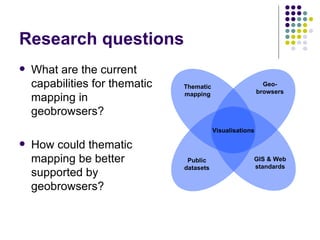
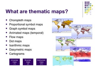
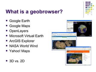
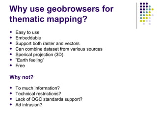
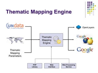
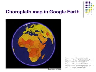
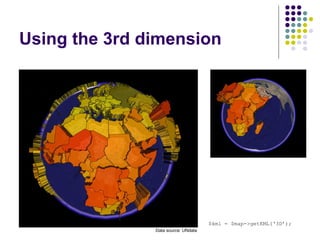
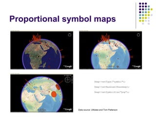
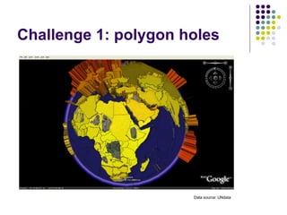
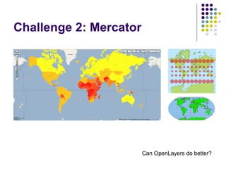
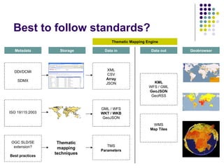
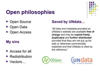
SlideShare a Scribd company logo
Using geobrowsers for thematic mapping Bjørn Sandvik MSc in Geographical Information Science University of Edinburgh Postgraduate Research Conference 17-19 March 2008 Supervisors: Bruce Gittings and James Reid
Research questions ,[object Object],[object Object],GIS & Web standards Thematic mapping Geo- browsers Public datasets Visualisations
What are thematic maps? ,[object Object],[object Object],[object Object],[object Object],[object Object],[object Object],[object Object],[object Object],[object Object],Univariate  maps (1) Bivariate  maps (2) Multivariate  maps (3+)
What is a geobrowser? ,[object Object],[object Object],[object Object],[object Object],[object Object],[object Object],[object Object],[object Object]
Why use geobrowsers for thematic mapping? ,[object Object],[object Object],[object Object],[object Object],[object Object],[object Object],[object Object],[object Object],[object Object],[object Object],[object Object],[object Object]
Thematic Mapping Engine Thematic Mapping Parameters OpenLayers PHP Library Web Interface Web Processing Service Thematic Mapping Engine
Choropleth map in Google Earth $map = new ThematicMap(); $map->setType("choropleth"); $map->addData($values); $map->addBorders($borders); $map->setColourRange($colors); $kml = $map->getKML(); Data source: UNdata
Using the 3rd dimension $kml = $map->getKML(‘3D’); Data source: UNdata
Proportional symbol maps $map->setType(“symbol"); $map->setBasenam($basemap); $map->setSymbolSize(”pop”); Data source: UNdata and Tom Patterson
Challenge 1: polygon holes Data source: UNdata
Challenge 2: Mercator Can OpenLayers do better?
Challenge 3: Performance
Challenge 4: Complexity function kmlSymbolCalculator( $longitude, $latitude, $distance, $points, $altitude ) { $EARTH_RADIUS_EQUATOR = 6378140.0; $RADIAN = 180 / pi(); $long = $longitude; $lat = $latitude; $long = $long / $RADIAN; $lat = $lat / $RADIAN; $f = 1/298.257; $e = 0.08181922; $kml = '<Polygon>' . PHP_EOL . '  <outerBoundaryIs>' . PHP_EOL . '  <LinearRing>' . PHP_EOL . '  <coordinates>'; for ( $bearing = 0; $bearing <= 360; $bearing += 360/$points)  {   $b = $bearing / $RADIAN;   $R = $EARTH_RADIUS_EQUATOR * (1 - $e * $e) / pow( (1 - $e*$e * pow(sin($lat),2)), 1.5);   $psi = $distance/$R;   $phi = pi()/2 - $lat;   $arccos = cos($psi) * cos($phi) + sin($psi) * sin($phi) * cos($b);   $latA = (pi()/2 - acos($arccos)) * $RADIAN; $arcsin = sin($b) * sin($psi) / sin($phi);   $longA = ($long - asin($arcsin)) * $RADIAN; $kml .= &quot; &quot;.$longA.&quot;,&quot;.$latA; } $kml .= '  </coordinates>' . PHP_EOL . '  </LinearRing>' . PHP_EOL . '  </outerBoundaryIs>' . PHP_EOL; return $kml; }
Challenge 5: Temporality
Best to follow standards? Thematic Mapping Engine DDI/DCMI SDMX Metadata ISO 19115:2003 OGC SLD/SE extension? Best practices Thematic mapping techniques GML / WFS WKT / WKB GeoJSON XML CSV Array JSON TMS Parameters Storage Data in Data out Geobrowser WMS Map Tiles KML WFS / GML GeoJSON GeoRSS
Open philosophies ,[object Object],[object Object],[object Object],[object Object],[object Object],[object Object],[object Object],[object Object],“ All data and metadata provided on UNdata’s website are available  free of charge  and may be  copied freely ,  duplicated  and  further distributed  provided that they are not put up for sale or otherwise commercially exploited and that UNdata is cited as the reference.”
GIS democratisation ,[object Object],[object Object]
Exploratory mapping ,[object Object],[object Object]
Website and blog thematicmapping.org

More Related Content

What's hot

Geospatial Web
Geospatial WebGeospatial Web
Geospatial Web
hchen1
 
GIS and Petroleum Land Management
GIS and Petroleum Land ManagementGIS and Petroleum Land Management
GIS and Petroleum Land Management
wlgardnerjr
 
OpenStreetMap mobile tools & visualisation
OpenStreetMap mobile tools & visualisationOpenStreetMap mobile tools & visualisation
OpenStreetMap mobile tools & visualisationTua Sarocha
 
GIS and GPS - applications in civil engg
GIS and GPS - applications  in civil enggGIS and GPS - applications  in civil engg
GIS and GPS - applications in civil enggPundlik Rathod
 
Agi 2008: Usability And Gis
Agi 2008: Usability And GisAgi 2008: Usability And Gis
Agi 2008: Usability And Gis
Muki Haklay
 
Geographic Information Systems in the Oil & Gas Industry
Geographic Information Systems in the Oil & Gas IndustryGeographic Information Systems in the Oil & Gas Industry
Geographic Information Systems in the Oil & Gas IndustryFrancois Viljoen
 
What is GIS?
What is GIS?What is GIS?
What is GIS?
Daniel Demonceau
 
Using Spatial Technologies in the Geography Classroom
Using Spatial Technologies in the Geography ClassroomUsing Spatial Technologies in the Geography Classroom
Using Spatial Technologies in the Geography Classroom
Rebecca Nicholas
 
Future of GIS, Moving to the Enterprise Platform
Future of GIS, Moving to the Enterprise PlatformFuture of GIS, Moving to the Enterprise Platform
Future of GIS, Moving to the Enterprise Platform
SSP Innovations
 
GPS Workshop
GPS WorkshopGPS Workshop
GPS Workshop
Vince123
 
OGA 2013 presentation
OGA 2013 presentationOGA 2013 presentation
OGA 2013 presentationmbucy21
 
Spatial Technology Resources for Teachers
Spatial Technology Resources for TeachersSpatial Technology Resources for Teachers
Spatial Technology Resources for Teachers
Rebecca Nicholas
 
Mapping the news 2012
Mapping the news 2012Mapping the news 2012
Mapping the news 2012
David Herzog
 
GeoClue - State of the Map 2007
GeoClue - State of the Map 2007GeoClue - State of the Map 2007
GeoClue - State of the Map 2007
Andrew Turner
 
Gis and GoogleEarth
Gis and GoogleEarthGis and GoogleEarth
Gis and GoogleEarth
akrishs
 
Geographic information system
Geographic information systemGeographic information system
Geographic information system
RahulChahel
 
Using Mapping For Targeting And Evaluation
Using Mapping For Targeting And EvaluationUsing Mapping For Targeting And Evaluation
Using Mapping For Targeting And Evaluation
Legal Services National Technology Assistance Project (LSNTAP)
 
The Social Lives Of Maps: Interaction Design and Maps
The Social Lives Of Maps: Interaction Design and MapsThe Social Lives Of Maps: Interaction Design and Maps
The Social Lives Of Maps: Interaction Design and Maps
weatherpattern
 
Geographic Information System and use in Agriculture
Geographic Information System and use in Agriculture Geographic Information System and use in Agriculture
Geographic Information System and use in Agriculture
PritiKumari131
 

What's hot (20)

Geospatial Web
Geospatial WebGeospatial Web
Geospatial Web
 
GIS and Petroleum Land Management
GIS and Petroleum Land ManagementGIS and Petroleum Land Management
GIS and Petroleum Land Management
 
OpenStreetMap mobile tools & visualisation
OpenStreetMap mobile tools & visualisationOpenStreetMap mobile tools & visualisation
OpenStreetMap mobile tools & visualisation
 
GIS
GISGIS
GIS
 
GIS and GPS - applications in civil engg
GIS and GPS - applications  in civil enggGIS and GPS - applications  in civil engg
GIS and GPS - applications in civil engg
 
Agi 2008: Usability And Gis
Agi 2008: Usability And GisAgi 2008: Usability And Gis
Agi 2008: Usability And Gis
 
Geographic Information Systems in the Oil & Gas Industry
Geographic Information Systems in the Oil & Gas IndustryGeographic Information Systems in the Oil & Gas Industry
Geographic Information Systems in the Oil & Gas Industry
 
What is GIS?
What is GIS?What is GIS?
What is GIS?
 
Using Spatial Technologies in the Geography Classroom
Using Spatial Technologies in the Geography ClassroomUsing Spatial Technologies in the Geography Classroom
Using Spatial Technologies in the Geography Classroom
 
Future of GIS, Moving to the Enterprise Platform
Future of GIS, Moving to the Enterprise PlatformFuture of GIS, Moving to the Enterprise Platform
Future of GIS, Moving to the Enterprise Platform
 
GPS Workshop
GPS WorkshopGPS Workshop
GPS Workshop
 
OGA 2013 presentation
OGA 2013 presentationOGA 2013 presentation
OGA 2013 presentation
 
Spatial Technology Resources for Teachers
Spatial Technology Resources for TeachersSpatial Technology Resources for Teachers
Spatial Technology Resources for Teachers
 
Mapping the news 2012
Mapping the news 2012Mapping the news 2012
Mapping the news 2012
 
GeoClue - State of the Map 2007
GeoClue - State of the Map 2007GeoClue - State of the Map 2007
GeoClue - State of the Map 2007
 
Gis and GoogleEarth
Gis and GoogleEarthGis and GoogleEarth
Gis and GoogleEarth
 
Geographic information system
Geographic information systemGeographic information system
Geographic information system
 
Using Mapping For Targeting And Evaluation
Using Mapping For Targeting And EvaluationUsing Mapping For Targeting And Evaluation
Using Mapping For Targeting And Evaluation
 
The Social Lives Of Maps: Interaction Design and Maps
The Social Lives Of Maps: Interaction Design and MapsThe Social Lives Of Maps: Interaction Design and Maps
The Social Lives Of Maps: Interaction Design and Maps
 
Geographic Information System and use in Agriculture
Geographic Information System and use in Agriculture Geographic Information System and use in Agriculture
Geographic Information System and use in Agriculture
 

Viewers also liked

Java Koch Curves
Java Koch CurvesJava Koch Curves
Java Koch Curves
tcooper66
 
radio propagation
radio propagationradio propagation
radio propagation
ATTO RATHORE
 
Kml and Its Applications
Kml and Its ApplicationsKml and Its Applications
Kml and Its Applications
Ashok Basnet
 
Simulation of urban mobility (sumo) prest
Simulation of urban mobility (sumo) prestSimulation of urban mobility (sumo) prest
Simulation of urban mobility (sumo) prestJaskaranpreet Singh
 
Mobile CDS LTE Simulation Demo
Mobile CDS LTE Simulation Demo Mobile CDS LTE Simulation Demo
Mobile CDS LTE Simulation Demo
Dr. Edwin Hernandez
 
Create Your KML File by KML Editor
Create Your KML File by KML EditorCreate Your KML File by KML Editor
Create Your KML File by KML Editor
wang yaohui
 
Kml Basics Chpt 4 Styles &amp; Icons
Kml Basics Chpt  4   Styles &amp; IconsKml Basics Chpt  4   Styles &amp; Icons
Kml Basics Chpt 4 Styles &amp; Iconstcooper66
 
Kml Basics Chpt 5 Overlays
Kml Basics Chpt  5   OverlaysKml Basics Chpt  5   Overlays
Kml Basics Chpt 5 Overlaystcooper66
 
Kml Basics Chpt 2 Placemarks
Kml Basics Chpt  2   PlacemarksKml Basics Chpt  2   Placemarks
Kml Basics Chpt 2 Placemarkstcooper66
 
Becoming a Smarter City by Analyzing & Visualizing Spatial Data
Becoming a Smarter City by Analyzing & Visualizing Spatial DataBecoming a Smarter City by Analyzing & Visualizing Spatial Data
Becoming a Smarter City by Analyzing & Visualizing Spatial Data
Patrick Stotz
 
Kml Basics Chpt 1 Overview
Kml Basics Chpt  1   OverviewKml Basics Chpt  1   Overview
Kml Basics Chpt 1 Overviewtcooper66
 
Internet-enabled GIS for Planners
Internet-enabled GIS for PlannersInternet-enabled GIS for Planners
Internet-enabled GIS for Planners
John Reiser
 
02 probabilistic inference in graphical models
02 probabilistic inference in graphical models02 probabilistic inference in graphical models
02 probabilistic inference in graphical modelszukun
 
UMTS/WCDMA Call Flows for Handovers
UMTS/WCDMA Call Flows for HandoversUMTS/WCDMA Call Flows for Handovers
UMTS/WCDMA Call Flows for Handovers
Justin MA (馬嘉昌)
 
Optimizing Rail Data for Google Earth Mashup
Optimizing Rail Data for Google Earth MashupOptimizing Rail Data for Google Earth Mashup
Optimizing Rail Data for Google Earth Mashup
Safe Software
 
Big Data Analytics in RF - LTE - 4G Environments
Big Data Analytics in RF - LTE - 4G EnvironmentsBig Data Analytics in RF - LTE - 4G Environments
Big Data Analytics in RF - LTE - 4G Environments
Dr. Edwin Hernandez
 
Alex optimization guidelines - retainability huawei - rev.01
Alex    optimization guidelines - retainability huawei - rev.01Alex    optimization guidelines - retainability huawei - rev.01
Alex optimization guidelines - retainability huawei - rev.01
Victor Perez
 
Managing Spatial Data for Telecommunications Using FME
Managing Spatial Data for Telecommunications Using FMEManaging Spatial Data for Telecommunications Using FME
Managing Spatial Data for Telecommunications Using FME
Safe Software
 

Viewers also liked (20)

Java Koch Curves
Java Koch CurvesJava Koch Curves
Java Koch Curves
 
radio propagation
radio propagationradio propagation
radio propagation
 
Kml and Its Applications
Kml and Its ApplicationsKml and Its Applications
Kml and Its Applications
 
Simulation of urban mobility (sumo) prest
Simulation of urban mobility (sumo) prestSimulation of urban mobility (sumo) prest
Simulation of urban mobility (sumo) prest
 
Mobile CDS LTE Simulation Demo
Mobile CDS LTE Simulation Demo Mobile CDS LTE Simulation Demo
Mobile CDS LTE Simulation Demo
 
rf planning
rf planningrf planning
rf planning
 
Create Your KML File by KML Editor
Create Your KML File by KML EditorCreate Your KML File by KML Editor
Create Your KML File by KML Editor
 
Kml Basics Chpt 4 Styles &amp; Icons
Kml Basics Chpt  4   Styles &amp; IconsKml Basics Chpt  4   Styles &amp; Icons
Kml Basics Chpt 4 Styles &amp; Icons
 
Kml Basics Chpt 5 Overlays
Kml Basics Chpt  5   OverlaysKml Basics Chpt  5   Overlays
Kml Basics Chpt 5 Overlays
 
Kml Basics Chpt 2 Placemarks
Kml Basics Chpt  2   PlacemarksKml Basics Chpt  2   Placemarks
Kml Basics Chpt 2 Placemarks
 
Becoming a Smarter City by Analyzing & Visualizing Spatial Data
Becoming a Smarter City by Analyzing & Visualizing Spatial DataBecoming a Smarter City by Analyzing & Visualizing Spatial Data
Becoming a Smarter City by Analyzing & Visualizing Spatial Data
 
Kml Basics Chpt 1 Overview
Kml Basics Chpt  1   OverviewKml Basics Chpt  1   Overview
Kml Basics Chpt 1 Overview
 
Internet-enabled GIS for Planners
Internet-enabled GIS for PlannersInternet-enabled GIS for Planners
Internet-enabled GIS for Planners
 
02 probabilistic inference in graphical models
02 probabilistic inference in graphical models02 probabilistic inference in graphical models
02 probabilistic inference in graphical models
 
UMTS/WCDMA Call Flows for Handovers
UMTS/WCDMA Call Flows for HandoversUMTS/WCDMA Call Flows for Handovers
UMTS/WCDMA Call Flows for Handovers
 
Rf planning umts with atoll1
Rf planning umts with atoll1Rf planning umts with atoll1
Rf planning umts with atoll1
 
Optimizing Rail Data for Google Earth Mashup
Optimizing Rail Data for Google Earth MashupOptimizing Rail Data for Google Earth Mashup
Optimizing Rail Data for Google Earth Mashup
 
Big Data Analytics in RF - LTE - 4G Environments
Big Data Analytics in RF - LTE - 4G EnvironmentsBig Data Analytics in RF - LTE - 4G Environments
Big Data Analytics in RF - LTE - 4G Environments
 
Alex optimization guidelines - retainability huawei - rev.01
Alex    optimization guidelines - retainability huawei - rev.01Alex    optimization guidelines - retainability huawei - rev.01
Alex optimization guidelines - retainability huawei - rev.01
 
Managing Spatial Data for Telecommunications Using FME
Managing Spatial Data for Telecommunications Using FMEManaging Spatial Data for Telecommunications Using FME
Managing Spatial Data for Telecommunications Using FME
 

Similar to Using geobrowsers for thematic mapping

How to empower community by using GIS lecture 1
How to empower community by using GIS lecture 1How to empower community by using GIS lecture 1
How to empower community by using GIS lecture 1wang yaohui
 
GIS Data Types
GIS Data TypesGIS Data Types
GIS Data Types
John Reiser
 
GIS_Whirlwind_Tour.ppt
GIS_Whirlwind_Tour.pptGIS_Whirlwind_Tour.ppt
GIS_Whirlwind_Tour.ppt
Fatima891926
 
GIS_Whirlwind_Tour.ppt
GIS_Whirlwind_Tour.pptGIS_Whirlwind_Tour.ppt
GIS_Whirlwind_Tour.ppt
safayetmim1
 
GIS_Whirlwind_Tour.ppt
GIS_Whirlwind_Tour.pptGIS_Whirlwind_Tour.ppt
GIS_Whirlwind_Tour.ppt
vikramvsu
 
GIS_Whirlwind_Tour.ppt
GIS_Whirlwind_Tour.pptGIS_Whirlwind_Tour.ppt
GIS_Whirlwind_Tour.ppt
GodwinKingNyamador
 
Optimizing GIS based Systems
Optimizing GIS based SystemsOptimizing GIS based Systems
Optimizing GIS based Systems
Ajinkya Deshpande
 
Open geo data - technical issue
Open geo data  - technical issueOpen geo data  - technical issue
Open geo data - technical issue
Maurizio Napolitano
 
IEEE SIGHT Bombay section webinar talk on GIS & Remote Sensing-Introduction t...
IEEE SIGHT Bombay section webinar talk on GIS & Remote Sensing-Introduction t...IEEE SIGHT Bombay section webinar talk on GIS & Remote Sensing-Introduction t...
IEEE SIGHT Bombay section webinar talk on GIS & Remote Sensing-Introduction t...
AdityaAllamraju1
 
Introduction and Application of GIS
Introduction and Application of GISIntroduction and Application of GIS
Introduction and Application of GIS
Satish Taji
 
GIS in Nutshell
GIS in NutshellGIS in Nutshell
GIS in Nutshell
Reham Maher El-Safarini
 
Intro to GIS and Remote Sensing
Intro to GIS and Remote SensingIntro to GIS and Remote Sensing
Intro to GIS and Remote Sensing
John Reiser
 
OpenStreetMap and CycleStreets: collaborative map-making and cartography in t...
OpenStreetMap and CycleStreets: collaborative map-making and cartography in t...OpenStreetMap and CycleStreets: collaborative map-making and cartography in t...
OpenStreetMap and CycleStreets: collaborative map-making and cartography in t...
CycleStreets
 
Volunteered Geographic Information and OpenStreetMap
Volunteered Geographic Information and OpenStreetMapVolunteered Geographic Information and OpenStreetMap
Volunteered Geographic Information and OpenStreetMap
chippy
 
Intro GIS.pptx
Intro GIS.pptxIntro GIS.pptx
Intro GIS.pptx
SamiDan2
 
Introduction to arc gis
Introduction to arc gisIntroduction to arc gis
Introduction to arc gis
Mohamed Hamed
 
GIS and Map Tiles
GIS and Map TilesGIS and Map Tiles
GIS and Map Tiles
Petr Pridal
 
Gis capabilities on Big Data Systems
Gis capabilities on Big Data SystemsGis capabilities on Big Data Systems
Gis capabilities on Big Data Systems
Ahmad Jawwad
 

Similar to Using geobrowsers for thematic mapping (20)

How to empower community by using GIS lecture 1
How to empower community by using GIS lecture 1How to empower community by using GIS lecture 1
How to empower community by using GIS lecture 1
 
GIS Data Types
GIS Data TypesGIS Data Types
GIS Data Types
 
GIS_Whirlwind_Tour.ppt
GIS_Whirlwind_Tour.pptGIS_Whirlwind_Tour.ppt
GIS_Whirlwind_Tour.ppt
 
GIS_Whirlwind_Tour.ppt
GIS_Whirlwind_Tour.pptGIS_Whirlwind_Tour.ppt
GIS_Whirlwind_Tour.ppt
 
GIS_Whirlwind_Tour.ppt
GIS_Whirlwind_Tour.pptGIS_Whirlwind_Tour.ppt
GIS_Whirlwind_Tour.ppt
 
GIS_Whirlwind_Tour.ppt
GIS_Whirlwind_Tour.pptGIS_Whirlwind_Tour.ppt
GIS_Whirlwind_Tour.ppt
 
Optimizing GIS based Systems
Optimizing GIS based SystemsOptimizing GIS based Systems
Optimizing GIS based Systems
 
Open geo data - technical issue
Open geo data  - technical issueOpen geo data  - technical issue
Open geo data - technical issue
 
IEEE SIGHT Bombay section webinar talk on GIS & Remote Sensing-Introduction t...
IEEE SIGHT Bombay section webinar talk on GIS & Remote Sensing-Introduction t...IEEE SIGHT Bombay section webinar talk on GIS & Remote Sensing-Introduction t...
IEEE SIGHT Bombay section webinar talk on GIS & Remote Sensing-Introduction t...
 
Introduction and Application of GIS
Introduction and Application of GISIntroduction and Application of GIS
Introduction and Application of GIS
 
GIS in Nutshell
GIS in NutshellGIS in Nutshell
GIS in Nutshell
 
Intro to GIS and Remote Sensing
Intro to GIS and Remote SensingIntro to GIS and Remote Sensing
Intro to GIS and Remote Sensing
 
OpenStreetMap and CycleStreets: collaborative map-making and cartography in t...
OpenStreetMap and CycleStreets: collaborative map-making and cartography in t...OpenStreetMap and CycleStreets: collaborative map-making and cartography in t...
OpenStreetMap and CycleStreets: collaborative map-making and cartography in t...
 
Volunteered Geographic Information and OpenStreetMap
Volunteered Geographic Information and OpenStreetMapVolunteered Geographic Information and OpenStreetMap
Volunteered Geographic Information and OpenStreetMap
 
Overview of gis new
Overview of gis newOverview of gis new
Overview of gis new
 
Intro GIS.pptx
Intro GIS.pptxIntro GIS.pptx
Intro GIS.pptx
 
Deploma
DeplomaDeploma
Deploma
 
Introduction to arc gis
Introduction to arc gisIntroduction to arc gis
Introduction to arc gis
 
GIS and Map Tiles
GIS and Map TilesGIS and Map Tiles
GIS and Map Tiles
 
Gis capabilities on Big Data Systems
Gis capabilities on Big Data SystemsGis capabilities on Big Data Systems
Gis capabilities on Big Data Systems
 

Recently uploaded

UiPath Test Automation using UiPath Test Suite series, part 6
UiPath Test Automation using UiPath Test Suite series, part 6UiPath Test Automation using UiPath Test Suite series, part 6
UiPath Test Automation using UiPath Test Suite series, part 6
DianaGray10
 
Generative AI Deep Dive: Advancing from Proof of Concept to Production
Generative AI Deep Dive: Advancing from Proof of Concept to ProductionGenerative AI Deep Dive: Advancing from Proof of Concept to Production
Generative AI Deep Dive: Advancing from Proof of Concept to Production
Aggregage
 
Alt. GDG Cloud Southlake #33: Boule & Rebala: Effective AppSec in SDLC using ...
Alt. GDG Cloud Southlake #33: Boule & Rebala: Effective AppSec in SDLC using ...Alt. GDG Cloud Southlake #33: Boule & Rebala: Effective AppSec in SDLC using ...
Alt. GDG Cloud Southlake #33: Boule & Rebala: Effective AppSec in SDLC using ...
James Anderson
 
Monitoring Java Application Security with JDK Tools and JFR Events
Monitoring Java Application Security with JDK Tools and JFR EventsMonitoring Java Application Security with JDK Tools and JFR Events
Monitoring Java Application Security with JDK Tools and JFR Events
Ana-Maria Mihalceanu
 
Observability Concepts EVERY Developer Should Know -- DeveloperWeek Europe.pdf
Observability Concepts EVERY Developer Should Know -- DeveloperWeek Europe.pdfObservability Concepts EVERY Developer Should Know -- DeveloperWeek Europe.pdf
Observability Concepts EVERY Developer Should Know -- DeveloperWeek Europe.pdf
Paige Cruz
 
Secstrike : Reverse Engineering & Pwnable tools for CTF.pptx
Secstrike : Reverse Engineering & Pwnable tools for CTF.pptxSecstrike : Reverse Engineering & Pwnable tools for CTF.pptx
Secstrike : Reverse Engineering & Pwnable tools for CTF.pptx
nkrafacyberclub
 
UiPath Test Automation using UiPath Test Suite series, part 5
UiPath Test Automation using UiPath Test Suite series, part 5UiPath Test Automation using UiPath Test Suite series, part 5
UiPath Test Automation using UiPath Test Suite series, part 5
DianaGray10
 
National Security Agency - NSA mobile device best practices
National Security Agency - NSA mobile device best practicesNational Security Agency - NSA mobile device best practices
National Security Agency - NSA mobile device best practices
Quotidiano Piemontese
 
GraphSummit Singapore | Graphing Success: Revolutionising Organisational Stru...
GraphSummit Singapore | Graphing Success: Revolutionising Organisational Stru...GraphSummit Singapore | Graphing Success: Revolutionising Organisational Stru...
GraphSummit Singapore | Graphing Success: Revolutionising Organisational Stru...
Neo4j
 
Goodbye Windows 11: Make Way for Nitrux Linux 3.5.0!
Goodbye Windows 11: Make Way for Nitrux Linux 3.5.0!Goodbye Windows 11: Make Way for Nitrux Linux 3.5.0!
Goodbye Windows 11: Make Way for Nitrux Linux 3.5.0!
SOFTTECHHUB
 
20240609 QFM020 Irresponsible AI Reading List May 2024
20240609 QFM020 Irresponsible AI Reading List May 202420240609 QFM020 Irresponsible AI Reading List May 2024
20240609 QFM020 Irresponsible AI Reading List May 2024
Matthew Sinclair
 
How to Get CNIC Information System with Paksim Ga.pptx
How to Get CNIC Information System with Paksim Ga.pptxHow to Get CNIC Information System with Paksim Ga.pptx
How to Get CNIC Information System with Paksim Ga.pptx
danishmna97
 
DevOps and Testing slides at DASA Connect
DevOps and Testing slides at DASA ConnectDevOps and Testing slides at DASA Connect
DevOps and Testing slides at DASA Connect
Kari Kakkonen
 
Epistemic Interaction - tuning interfaces to provide information for AI support
Epistemic Interaction - tuning interfaces to provide information for AI supportEpistemic Interaction - tuning interfaces to provide information for AI support
Epistemic Interaction - tuning interfaces to provide information for AI support
Alan Dix
 
Uni Systems Copilot event_05062024_C.Vlachos.pdf
Uni Systems Copilot event_05062024_C.Vlachos.pdfUni Systems Copilot event_05062024_C.Vlachos.pdf
Uni Systems Copilot event_05062024_C.Vlachos.pdf
Uni Systems S.M.S.A.
 
zkStudyClub - Reef: Fast Succinct Non-Interactive Zero-Knowledge Regex Proofs
zkStudyClub - Reef: Fast Succinct Non-Interactive Zero-Knowledge Regex ProofszkStudyClub - Reef: Fast Succinct Non-Interactive Zero-Knowledge Regex Proofs
zkStudyClub - Reef: Fast Succinct Non-Interactive Zero-Knowledge Regex Proofs
Alex Pruden
 
20240607 QFM018 Elixir Reading List May 2024
20240607 QFM018 Elixir Reading List May 202420240607 QFM018 Elixir Reading List May 2024
20240607 QFM018 Elixir Reading List May 2024
Matthew Sinclair
 
GridMate - End to end testing is a critical piece to ensure quality and avoid...
GridMate - End to end testing is a critical piece to ensure quality and avoid...GridMate - End to end testing is a critical piece to ensure quality and avoid...
GridMate - End to end testing is a critical piece to ensure quality and avoid...
ThomasParaiso2
 
FIDO Alliance Osaka Seminar: The WebAuthn API and Discoverable Credentials.pdf
FIDO Alliance Osaka Seminar: The WebAuthn API and Discoverable Credentials.pdfFIDO Alliance Osaka Seminar: The WebAuthn API and Discoverable Credentials.pdf
FIDO Alliance Osaka Seminar: The WebAuthn API and Discoverable Credentials.pdf
FIDO Alliance
 
GraphRAG is All You need? LLM & Knowledge Graph
GraphRAG is All You need? LLM & Knowledge GraphGraphRAG is All You need? LLM & Knowledge Graph
GraphRAG is All You need? LLM & Knowledge Graph
Guy Korland
 

Recently uploaded (20)

UiPath Test Automation using UiPath Test Suite series, part 6
UiPath Test Automation using UiPath Test Suite series, part 6UiPath Test Automation using UiPath Test Suite series, part 6
UiPath Test Automation using UiPath Test Suite series, part 6
 
Generative AI Deep Dive: Advancing from Proof of Concept to Production
Generative AI Deep Dive: Advancing from Proof of Concept to ProductionGenerative AI Deep Dive: Advancing from Proof of Concept to Production
Generative AI Deep Dive: Advancing from Proof of Concept to Production
 
Alt. GDG Cloud Southlake #33: Boule & Rebala: Effective AppSec in SDLC using ...
Alt. GDG Cloud Southlake #33: Boule & Rebala: Effective AppSec in SDLC using ...Alt. GDG Cloud Southlake #33: Boule & Rebala: Effective AppSec in SDLC using ...
Alt. GDG Cloud Southlake #33: Boule & Rebala: Effective AppSec in SDLC using ...
 
Monitoring Java Application Security with JDK Tools and JFR Events
Monitoring Java Application Security with JDK Tools and JFR EventsMonitoring Java Application Security with JDK Tools and JFR Events
Monitoring Java Application Security with JDK Tools and JFR Events
 
Observability Concepts EVERY Developer Should Know -- DeveloperWeek Europe.pdf
Observability Concepts EVERY Developer Should Know -- DeveloperWeek Europe.pdfObservability Concepts EVERY Developer Should Know -- DeveloperWeek Europe.pdf
Observability Concepts EVERY Developer Should Know -- DeveloperWeek Europe.pdf
 
Secstrike : Reverse Engineering & Pwnable tools for CTF.pptx
Secstrike : Reverse Engineering & Pwnable tools for CTF.pptxSecstrike : Reverse Engineering & Pwnable tools for CTF.pptx
Secstrike : Reverse Engineering & Pwnable tools for CTF.pptx
 
UiPath Test Automation using UiPath Test Suite series, part 5
UiPath Test Automation using UiPath Test Suite series, part 5UiPath Test Automation using UiPath Test Suite series, part 5
UiPath Test Automation using UiPath Test Suite series, part 5
 
National Security Agency - NSA mobile device best practices
National Security Agency - NSA mobile device best practicesNational Security Agency - NSA mobile device best practices
National Security Agency - NSA mobile device best practices
 
GraphSummit Singapore | Graphing Success: Revolutionising Organisational Stru...
GraphSummit Singapore | Graphing Success: Revolutionising Organisational Stru...GraphSummit Singapore | Graphing Success: Revolutionising Organisational Stru...
GraphSummit Singapore | Graphing Success: Revolutionising Organisational Stru...
 
Goodbye Windows 11: Make Way for Nitrux Linux 3.5.0!
Goodbye Windows 11: Make Way for Nitrux Linux 3.5.0!Goodbye Windows 11: Make Way for Nitrux Linux 3.5.0!
Goodbye Windows 11: Make Way for Nitrux Linux 3.5.0!
 
20240609 QFM020 Irresponsible AI Reading List May 2024
20240609 QFM020 Irresponsible AI Reading List May 202420240609 QFM020 Irresponsible AI Reading List May 2024
20240609 QFM020 Irresponsible AI Reading List May 2024
 
How to Get CNIC Information System with Paksim Ga.pptx
How to Get CNIC Information System with Paksim Ga.pptxHow to Get CNIC Information System with Paksim Ga.pptx
How to Get CNIC Information System with Paksim Ga.pptx
 
DevOps and Testing slides at DASA Connect
DevOps and Testing slides at DASA ConnectDevOps and Testing slides at DASA Connect
DevOps and Testing slides at DASA Connect
 
Epistemic Interaction - tuning interfaces to provide information for AI support
Epistemic Interaction - tuning interfaces to provide information for AI supportEpistemic Interaction - tuning interfaces to provide information for AI support
Epistemic Interaction - tuning interfaces to provide information for AI support
 
Uni Systems Copilot event_05062024_C.Vlachos.pdf
Uni Systems Copilot event_05062024_C.Vlachos.pdfUni Systems Copilot event_05062024_C.Vlachos.pdf
Uni Systems Copilot event_05062024_C.Vlachos.pdf
 
zkStudyClub - Reef: Fast Succinct Non-Interactive Zero-Knowledge Regex Proofs
zkStudyClub - Reef: Fast Succinct Non-Interactive Zero-Knowledge Regex ProofszkStudyClub - Reef: Fast Succinct Non-Interactive Zero-Knowledge Regex Proofs
zkStudyClub - Reef: Fast Succinct Non-Interactive Zero-Knowledge Regex Proofs
 
20240607 QFM018 Elixir Reading List May 2024
20240607 QFM018 Elixir Reading List May 202420240607 QFM018 Elixir Reading List May 2024
20240607 QFM018 Elixir Reading List May 2024
 
GridMate - End to end testing is a critical piece to ensure quality and avoid...
GridMate - End to end testing is a critical piece to ensure quality and avoid...GridMate - End to end testing is a critical piece to ensure quality and avoid...
GridMate - End to end testing is a critical piece to ensure quality and avoid...
 
FIDO Alliance Osaka Seminar: The WebAuthn API and Discoverable Credentials.pdf
FIDO Alliance Osaka Seminar: The WebAuthn API and Discoverable Credentials.pdfFIDO Alliance Osaka Seminar: The WebAuthn API and Discoverable Credentials.pdf
FIDO Alliance Osaka Seminar: The WebAuthn API and Discoverable Credentials.pdf
 
GraphRAG is All You need? LLM & Knowledge Graph
GraphRAG is All You need? LLM & Knowledge GraphGraphRAG is All You need? LLM & Knowledge Graph
GraphRAG is All You need? LLM & Knowledge Graph
 

Using geobrowsers for thematic mapping

  • 1. Using geobrowsers for thematic mapping Bjørn Sandvik MSc in Geographical Information Science University of Edinburgh Postgraduate Research Conference 17-19 March 2008 Supervisors: Bruce Gittings and James Reid
  • 2.
  • 3.
  • 4.
  • 5.
  • 6. Thematic Mapping Engine Thematic Mapping Parameters OpenLayers PHP Library Web Interface Web Processing Service Thematic Mapping Engine
  • 7. Choropleth map in Google Earth $map = new ThematicMap(); $map->setType(&quot;choropleth&quot;); $map->addData($values); $map->addBorders($borders); $map->setColourRange($colors); $kml = $map->getKML(); Data source: UNdata
  • 8. Using the 3rd dimension $kml = $map->getKML(‘3D’); Data source: UNdata
  • 9. Proportional symbol maps $map->setType(“symbol&quot;); $map->setBasenam($basemap); $map->setSymbolSize(”pop”); Data source: UNdata and Tom Patterson
  • 10. Challenge 1: polygon holes Data source: UNdata
  • 11. Challenge 2: Mercator Can OpenLayers do better?
  • 13. Challenge 4: Complexity function kmlSymbolCalculator( $longitude, $latitude, $distance, $points, $altitude ) { $EARTH_RADIUS_EQUATOR = 6378140.0; $RADIAN = 180 / pi(); $long = $longitude; $lat = $latitude; $long = $long / $RADIAN; $lat = $lat / $RADIAN; $f = 1/298.257; $e = 0.08181922; $kml = '<Polygon>' . PHP_EOL . ' <outerBoundaryIs>' . PHP_EOL . ' <LinearRing>' . PHP_EOL . ' <coordinates>'; for ( $bearing = 0; $bearing <= 360; $bearing += 360/$points) { $b = $bearing / $RADIAN; $R = $EARTH_RADIUS_EQUATOR * (1 - $e * $e) / pow( (1 - $e*$e * pow(sin($lat),2)), 1.5); $psi = $distance/$R; $phi = pi()/2 - $lat; $arccos = cos($psi) * cos($phi) + sin($psi) * sin($phi) * cos($b); $latA = (pi()/2 - acos($arccos)) * $RADIAN; $arcsin = sin($b) * sin($psi) / sin($phi); $longA = ($long - asin($arcsin)) * $RADIAN; $kml .= &quot; &quot;.$longA.&quot;,&quot;.$latA; } $kml .= ' </coordinates>' . PHP_EOL . ' </LinearRing>' . PHP_EOL . ' </outerBoundaryIs>' . PHP_EOL; return $kml; }
  • 15. Best to follow standards? Thematic Mapping Engine DDI/DCMI SDMX Metadata ISO 19115:2003 OGC SLD/SE extension? Best practices Thematic mapping techniques GML / WFS WKT / WKB GeoJSON XML CSV Array JSON TMS Parameters Storage Data in Data out Geobrowser WMS Map Tiles KML WFS / GML GeoJSON GeoRSS
  • 16.
  • 17.
  • 18.
  • 19. Website and blog thematicmapping.org