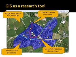
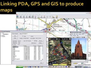
Edexcel Unit 2: David Holmes, Principal Examiner
“ GIS has the ability to store, retrieve, manipulate and analyse a range of spatially related data” Its all  about layers of spatial information  that can be turned on or off.  True GIS is underpinned by a vast dataset with gives the locations (‘vectors’) of particular values.  This allows the software then to plot information.  Even the free web-based GIS works like this, except that the user has very much less control over the actual software and cannot easily interrogate the data set. So, the GIS user can: ask questions of data related to the map search for patterns and distributions investigate the underlying relationships  between different sets of data
There are lots of places that you can experience this on the internet Simple is fine! Lots of resources, e.g. Teachers TV
 
Using GPS and GIS to find routes in a car – ‘Tom Tom’
Google maps/ earth – free online GIS Yellow pins are placemarks  Student photos added along transects Coloured transect lines added
GE Graph can be used to create your on ‘kml’ overlays  of graphical  data
 
An operator may choose display options which completely hide or over emphasise spatial patterns. Colour, symbol size, method of data classification, number of classes, data aggregation are all factors which are manipulated in the production of maps. Who created the data set – and why. Age of data?
building lake river woodland Real World Low spatial resolution Higher spatial resolution At what spatial resolution do we represent  places? What are potential implications of this choice?
Big issues if used to determine practice / policy! Type of burglary? How reported / recorded? Resolution of mapping data Burglary hotspots probation
What do we mean by VF? Google Earth (including ‘Street maps’, Mapping software, e.g. Anquet Maps, Memory Map, Aegis Use as a top-up tool Allows more ‘coverage’ – use simulations and suggestions (there is a lot of overlap in the specification).  RESOURCE EFFICIENT
 

Gis

  • 1.
    Edexcel Unit 2:David Holmes, Principal Examiner
  • 2.
    “ GIS hasthe ability to store, retrieve, manipulate and analyse a range of spatially related data” Its all about layers of spatial information that can be turned on or off. True GIS is underpinned by a vast dataset with gives the locations (‘vectors’) of particular values. This allows the software then to plot information. Even the free web-based GIS works like this, except that the user has very much less control over the actual software and cannot easily interrogate the data set. So, the GIS user can: ask questions of data related to the map search for patterns and distributions investigate the underlying relationships between different sets of data
  • 3.
    There are lotsof places that you can experience this on the internet Simple is fine! Lots of resources, e.g. Teachers TV
  • 4.
  • 5.
    Using GPS andGIS to find routes in a car – ‘Tom Tom’
  • 6.
    Google maps/ earth– free online GIS Yellow pins are placemarks Student photos added along transects Coloured transect lines added
  • 7.
    GE Graph canbe used to create your on ‘kml’ overlays of graphical data
  • 8.
  • 9.
    An operator maychoose display options which completely hide or over emphasise spatial patterns. Colour, symbol size, method of data classification, number of classes, data aggregation are all factors which are manipulated in the production of maps. Who created the data set – and why. Age of data?
  • 10.
    building lake riverwoodland Real World Low spatial resolution Higher spatial resolution At what spatial resolution do we represent places? What are potential implications of this choice?
  • 11.
    Big issues ifused to determine practice / policy! Type of burglary? How reported / recorded? Resolution of mapping data Burglary hotspots probation
  • 12.
    What do wemean by VF? Google Earth (including ‘Street maps’, Mapping software, e.g. Anquet Maps, Memory Map, Aegis Use as a top-up tool Allows more ‘coverage’ – use simulations and suggestions (there is a lot of overlap in the specification). RESOURCE EFFICIENT
  • 13.

Editor's Notes

  • #6 Adding Value with GIS 15th October 2003 [email_address] These images are from route mapping software which many people buy for their PDAs, whilst this is very interesting and good for routes and can be used to investigate a range of things regarding routes and time taken for journeys, it does not have much topological data on the maps.
  • #9 Adding Value with GIS 15th October 2003 [email_address] There is software for PDAs and GPS which offer OS maps and 50,000 and now 25,000 (as well as the potential for aerial photos) which can be used for routes, recording data and linking hotspots with other data. The package comes with software to work on the PC as well as a PDA.