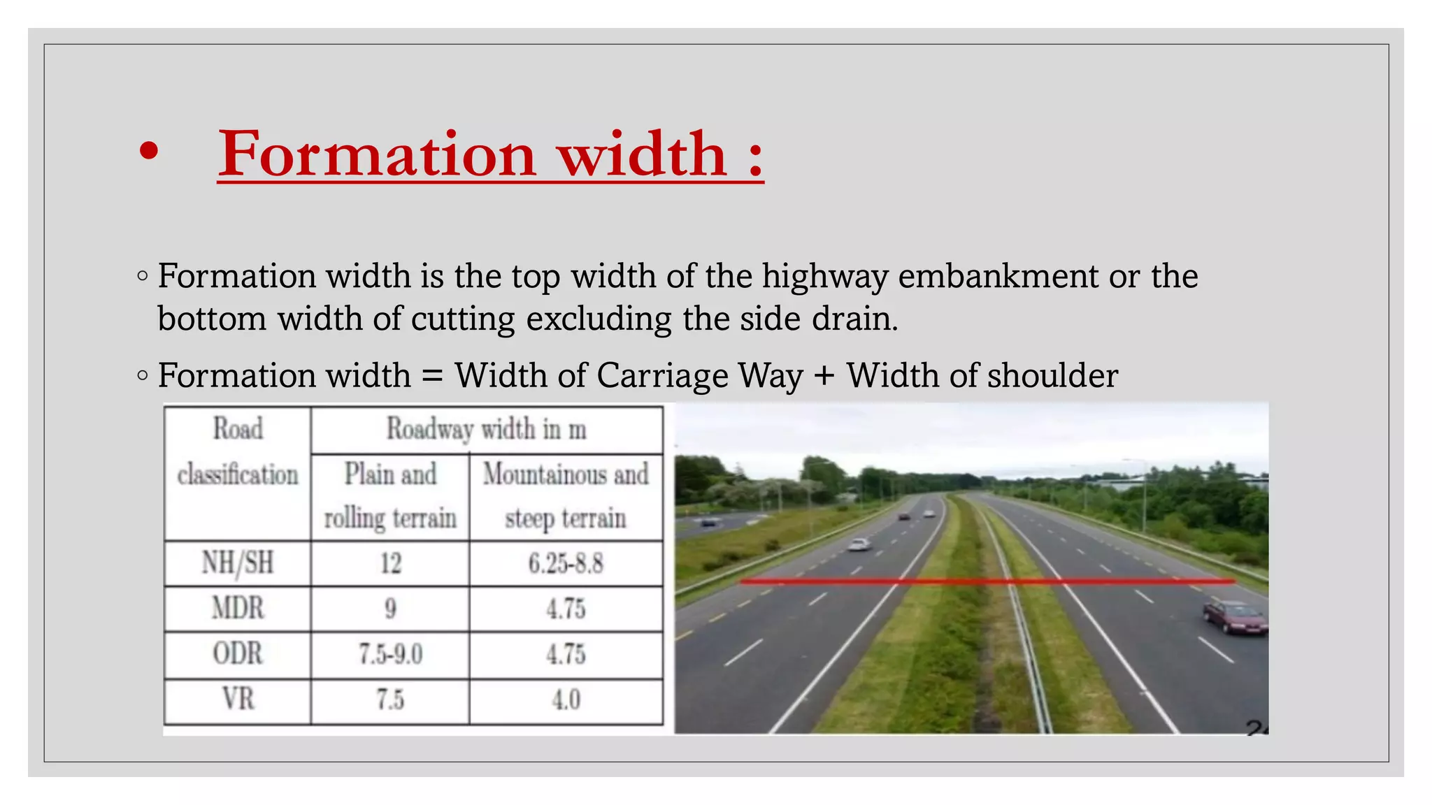
TRANSPORTATION
ENGINEERING
Prepare by-
Gaurav Maurya, Civil Engg. 2nd yr
TRANSPORTATION
ENGINEERING
Prepared by-
Gaurav Maurya, Civil Engg. 2nd Yr
ITS ENGINEERING COLLEGE
A
PROJECT
REPORT
ON
“TRANSPORTATION
ENGINEERING SYSTEM”
Submitted To- Submitted By-
Mr. SAMEER KUMAR SINGH,
Assistant Professor,
CIVIL ENGINEERING DEPT.
GAURAV MAURYA,
B. Tech, Civil Engg.
2nd Year
What is
Transportation
Engineering?
Transportation
Engineering is a branch
of Civil Engineering that is
involved in the planning,
design, operation, and
maintenance of safe and
efficient transportation
systems. These systems
include roadways, railways,
airways and waterways.
Role of Transportation
Every product needs
transportation
Better system can
provide easy access and
benefit to low costing
of products.
Availability of raw
material can be
provided to
manufacturing units.
People of remote area
can come closer to the
city or town.
People from different
parts of country can
reach far places with
convenience and in less
time.
Role of Transportation in National
Development
Economic
Growth.
Place utility
of goods.
Time utility
of goods.
Mass
Production.
Exploitation
of natural
resources.
Urbanization
Industrial
Development.
Agriculture
Development.
Transportation
Ways
1. Railways
◦ Surface
◦ Underground
◦ Elevated
◦ LRT (Light Rail Transit)
2. Roadways
3. Airways
4. Water Ways
Surface Transportation & Aviation
Modes of Transportation :-
Roadways
◦ CLASSIFICATION OF ROADS-
1. Express Ways
2. National Highway
3. State Highway
4. Major District Road (MDR)
5. Other District Road (ODR)
6. Village Road (VR)
1. Express Ways
◦ These are suggested in Third Road development plan (1981-
2001).
◦ These are used to connect the Metropolitan cities like Mumbai,
Delhi, Lucknow, Kolkata, Chennai.
◦ They have the highest design speed.
◦ They should have at least four lanes.
• Express Ways in India
◦ Purvanchal Expressway- 6 Lane, 340 Km
◦ Delhi-Mumbai Expressway- 8 Lane, 1350 Km (Under Construction)
◦ Agra- Lucknow Expressway- 6 Lane, 302 Km
◦ Mumbai-Pune Expressway- India’s first 6 Lane, 93 Km
◦ Jaipur-Kishangarh Expressway – 6 Lane, 90 Km
◦ Ahemdabad-Vadodara Expressway – 95 Km
◦ Delhi-Gurgaon Expressway- 28 Km,
◦ Western Expressway- 10 Lane, 25.33 Km
◦ Eastern Expressway- 6 Lane, 23 Km
◦ Yamuna Expressway OR Taj Expressway- 6 Lane, 165 Km
◦ Noida-Greater Noida Expressway- 6 Lane, 24Km
2. National Highways
◦ They run through the Length and Breadth of the country.
◦ They connect national capital to all state capitals, major cities,
towns, border areas.
◦ They should have at least two traffic lanes, good surface
finishing and excellent strength to carry heavy traffic.
◦ The construction and maintenance of these roads is usually
carried out by Central government.
3. State Highways
◦ These are main roads running within the states They connect
important towns, cities of state with National Highway.
◦ These are generally one lane but two lanes are always be
preferred.
◦ They have modern type of bituminous or Concrete surfacing.
◦ The construction and maintenance of these roads are usually
carried out by the State Government.
4. District Roads
1. Major District Road-
◦ These roads connect all the districts, all production areas and
markets with State Highway or National Highway or Railways.
◦ They have single metalled lane of traffic.
2. Other District Road-
◦ These provide links to villages and serve a large rural
population.
◦ They should have good metalled surface and proper drainage.
◦ Construction and maintenance are carried by District
Authority or Zila Parishad (Z.P.).
5. Village Roads
◦These connect the villages with each other and also
towns nearby.
◦These are generally established earth roads but metal
surface is preferred.
◦The construction and maintenance are carried by local
District boards.
Definition of Geometric Design :
◦ Geometric design of highways deals with the dimensions and
layout of visible features of the highway.
◦ Geometric design fulfills the requirements of the driver and the
vehicle, such as comfort, efficiency and safety.
◦ Proper geometric design will help in the reduction of accidents
and their severity.
Road Alignment :
Alignment : is an arrangement in a straight line or in correct
relative positions.
◦ The position or the layout of the central line of the highway on
the ground is called the alignment.
◦ Horizontal alignment includes straight and curved paths.
◦ Vertical alignment includes level and gradients.
Elements of Road :
Cross-Section of Road :
• Carriage Way :
◦The Width of pavement way on which vehicles
travel is called carriage way.
• Road Shoulders :
◦ Shoulders are provided along the road edge to serve as an emergency
lane for vehicles.
◦ As per IRC, the min. width of shoulder should be 2.5m.
Uses :
◦ Repair of broken down vehicles
◦ Overtaking operations
◦ To act as an emergency lane
◦ For future widening of Road
• Formation width :
◦ Formation width is the top width of the highway embankment or the
bottom width of cutting excluding the side drain.
◦ Formation width = Width of Carriage Way + Width of shoulder
• Right of way :
◦ Right of way is the area of land acquired for the land , along its alignment.
◦ It is the distance between boundary stones of road on either side of road.
• Side slope :
◦ The slope of earthwork in Filling ( embankment ) or
cutting is called side slope.
• Berm :
◦ The distance between the road toe and inner edge of borrow
pit is called berm.
◦ It prevents the erosion of embankment soil.
• Side Drain :
◦ For the drainage of rain water, drains are provided on either
side of the road.
◦ Normally, Side drain are required for road in cutting.
◦ For road in embankment side drain is not necessary.
• Kerbs :
The boundaries between pavement and shoulders
or footpath are known as kerbs.
• Pavement Design :
◦ A highway pavement is a structure consisting of superimposed layers of
processed materials above the natural soil sub-grade.
◦ The pavement must provide an acceptable riding quality, adequate skid
resistance, favourable light reflecting characteristics, and low noise
pollution.
Cross section of different types of road as
per IRC :
• Cross-Section of of highway in urban
areas
• Camber
◦ Camber or cross slope is the slope provided to the road surface in
the transverse direction to drain off rain water from the road
surface.
◦ The rate of camber is usually designated by 1 in n (1 vertical to n
horizontal)
Advantages & Disadvantages of Roadways
Advantages
◦ MAXIMUMFLEXIBILITY FOR
TRAVEL.
◦ IT PERMITS ANY MOAD OF ROAD
VEHICAL.
◦ IT PROVIDES DOOR-TO- DOOR
SERVICE.
◦ IT SAVES TIME FOR SHORT
DISTANCE.
◦ CONSTRUCTION AND
MAINTAINANCECOST IS LOW.
Disadvantages
◦ GOODS CARRYING CAPACITYIS
LOW.
◦ SPEED IS LOW COMPARE TO AIR
AND WATERWAY.
◦ LESS COMFORT AND SAFE.
◦ UNECONOMICALFOR LONG
DISTANCE.
◦ NUMBER OF ROAD ACCIDENT IS
HIGH.
RAILWAYS
Railways
◦ Categories of Railway
1. Trunk Routes
2. Main Line
3. Branch Line
◦ Types of Railway
1. Surface
2. Underground
3. Elevated
• Rail Gauges
◦The gauge of a railway track is defined as the
clear minimum perpendicular distance between
the inner faces of the two rails.
◦TYPES OF GAUGE
1.BROAD GAUGE : 1.676 m
2.METRE GAUGE : 1.0 m
3.NARROW GAUGE : 0.762 m
◦TYPES OF RAIL
1.DOUBLE HEADED RAIL
2.BULL HEADED RAIL
3.FLAT-FOOTED RAIL
◦ TYPES OF SLEEPER
1.WOODEN
2.METAL
i) CAST IRON
ii) STEEL
3. CONCRETE
i) RAINFORCED CONCRETE
ii) PRESRESSED CONCRETE
• Cross-Section of Railway
• Ballast
Ballast is the granular material usually
broken stone or bricks single and kanker,
gravel and sand placed and packed and
around the sleeper to transmit Load from
sleeper to formation Layer.
Size = 20mm – 65mm
• RAILS
The rolled steel sections laid end to end in two
parallel lines over sleepers to form a railway track
are known as RAILS.
• Double Headed Rail
The rails having their head and foot of same
dimensions are known as double headed rail
(D.H.).
• Flat Footed Rail
The rail section having their foot rolled to a
flat are known as flat footed rails.
• Bull Headed Rail
The rails sections having their head of more
dimension then that of their foot are known
as bull headed rails (B.H.).
• Rail Joints
1.FISH PLATE JOINT
2.FASTENERS JOINTS
3.SLIDE CHAIARS JOINT
4.JUNCTION PLATE JOINT
5.BEARING PLATE JOINT
• Fish Plate Joint
• Fasteners Joints
• SLIDE CHIAIRS JOINTS
• Junction Plate
Sleepers
Sleepers are members generally laid transverse to
the rails, on which the rails are fixed to transfer
the loads from the rails to the ballast and the
subgrade.
• Types of Sleepers
1.Wooden Sleepers
2.Metal Sleepers
3.Concrete Sleepers
• Metal Sleepers
• Concrete Sleepers
Advantages & Disadvantages of Railways
Advantages
◦ GOODS CARRYING CAPACITYIS
HIGH.
◦ SPEED IS HIGH COMPARETO
ROADWAYS.
◦ CHEAPER THEN AIRWAYS.
◦ COMFORTABLE FOR LONG
DISTANCETRAVEL.
◦ IT INCRESES TRADE, COMMERS
AND BUSINESS
Disadvantages
◦ IT IS NOT FLEXIBLE.
◦ IT DEPENDENT ON ROADWAY.
◦ TRAIN RUNS AS PER SCHEDULES.
◦ MAINTAINANCECOST IS HIGH.
◦ IT PERMITS DEFINITEMODE OF
TRANSPORT
AIRWAYS
Airways
◦ Types of Airports
1. International Airports
2. Domestic Airports
3. Military Aerodromes
◦ Types of Air Field
1. Flexible (Bituminous)
2. Rigid (Cement Concrete)
Advantages & Disadvantages of Airways
Advantages
◦ IT DOES NOT REQUIRE A TRACKS.
◦ IT IS USEFUL IN MILITARY
ACTIVITIES.
◦ FASTEST MODE OF
TRANSPORTATION.
◦ IT IS A POWERFUL MEAN OF
ATTACK.
◦ IT HELPS IN AERIAL.
◦ COMFORTABLE & QUICK SERVICES.
Disadvantages
◦ IT IS MOST EXPENSIVE.
◦ CONSTRUCTION COST IS HIGH FOR
AIRPORTS AND AIRCRAFTS.
◦ FUEL CONSUMPTION IS HIGH.
◦ MAINTAINANCE COST IS HIGH FOR
AIRCRAFT.
◦ THE CHANCES OF BREAKDOWNS
AND ACCIDENTS ARE HIGH AS
COMPARED TO OTHER MODES OF
TRANSPORTATION.
WATERWAYS
• Harbour
A harbor is an area of water that is protected from wind and wave and
harbor or harbour is a sheltered body of water where ships, boats, and
barges can be docked. Harbors can be man-made or natural. A natural
harbor is surrounded on most sides by land.
i) Natural Habour
ii) Semi Natural Harbour
iii) Artificial Harbour
• Natural Harbour
• Semi-Natural Harbour
• Artificial Harbour
Ports
◦Major Ports
◦Minor Ports
• Types of Docks
1.Dry Docks
2.Wet Docks
• Barge
◦A barge is a flat-bottomed boat, built mainly
for river and canal transport of bulk goods.
• Advantages & Disadvantages of
Waterways
Advantages
◦ NO NEED OF CONSTRUTING
TRACKS.
◦ IT REQUIRES CHEAP MOTIVE
POWER.
◦ CHEAPEST MODE OF
TRANSPORTATION.
◦ IT PROVIDES EFFICIENT MODE
OF DEFENCE.
◦ IT HELPS IN GROWTH OF
INDUSTRIES
Disadvantages
◦ IT IS SLOW.
◦ STROMS CAN CAUSE GREAT
LOSS.
◦ IT IS USEFUL ALONG
PARTICULAR ROUTES.
◦ MAINTAINANCE COST IS HIGH.
◦ IT HAS LIMITED CONNECTIVITY.
Transportation Engineering System

Transportation Engineering System

  • 1.
    TRANSPORTATION ENGINEERING Prepare by- Gaurav Maurya,Civil Engg. 2nd yr TRANSPORTATION ENGINEERING Prepared by- Gaurav Maurya, Civil Engg. 2nd Yr
  • 2.
    ITS ENGINEERING COLLEGE A PROJECT REPORT ON “TRANSPORTATION ENGINEERINGSYSTEM” Submitted To- Submitted By- Mr. SAMEER KUMAR SINGH, Assistant Professor, CIVIL ENGINEERING DEPT. GAURAV MAURYA, B. Tech, Civil Engg. 2nd Year
  • 3.
    What is Transportation Engineering? Transportation Engineering isa branch of Civil Engineering that is involved in the planning, design, operation, and maintenance of safe and efficient transportation systems. These systems include roadways, railways, airways and waterways.
  • 4.
    Role of Transportation Everyproduct needs transportation Better system can provide easy access and benefit to low costing of products. Availability of raw material can be provided to manufacturing units. People of remote area can come closer to the city or town. People from different parts of country can reach far places with convenience and in less time.
  • 5.
    Role of Transportationin National Development Economic Growth. Place utility of goods. Time utility of goods. Mass Production. Exploitation of natural resources. Urbanization Industrial Development. Agriculture Development.
  • 6.
    Transportation Ways 1. Railways ◦ Surface ◦Underground ◦ Elevated ◦ LRT (Light Rail Transit) 2. Roadways 3. Airways 4. Water Ways
  • 7.
  • 8.
  • 9.
    Roadways ◦ CLASSIFICATION OFROADS- 1. Express Ways 2. National Highway 3. State Highway 4. Major District Road (MDR) 5. Other District Road (ODR) 6. Village Road (VR)
  • 11.
    1. Express Ways ◦These are suggested in Third Road development plan (1981- 2001). ◦ These are used to connect the Metropolitan cities like Mumbai, Delhi, Lucknow, Kolkata, Chennai. ◦ They have the highest design speed. ◦ They should have at least four lanes.
  • 12.
    • Express Waysin India ◦ Purvanchal Expressway- 6 Lane, 340 Km ◦ Delhi-Mumbai Expressway- 8 Lane, 1350 Km (Under Construction) ◦ Agra- Lucknow Expressway- 6 Lane, 302 Km ◦ Mumbai-Pune Expressway- India’s first 6 Lane, 93 Km ◦ Jaipur-Kishangarh Expressway – 6 Lane, 90 Km ◦ Ahemdabad-Vadodara Expressway – 95 Km ◦ Delhi-Gurgaon Expressway- 28 Km, ◦ Western Expressway- 10 Lane, 25.33 Km ◦ Eastern Expressway- 6 Lane, 23 Km ◦ Yamuna Expressway OR Taj Expressway- 6 Lane, 165 Km ◦ Noida-Greater Noida Expressway- 6 Lane, 24Km
  • 13.
    2. National Highways ◦They run through the Length and Breadth of the country. ◦ They connect national capital to all state capitals, major cities, towns, border areas. ◦ They should have at least two traffic lanes, good surface finishing and excellent strength to carry heavy traffic. ◦ The construction and maintenance of these roads is usually carried out by Central government.
  • 14.
    3. State Highways ◦These are main roads running within the states They connect important towns, cities of state with National Highway. ◦ These are generally one lane but two lanes are always be preferred. ◦ They have modern type of bituminous or Concrete surfacing. ◦ The construction and maintenance of these roads are usually carried out by the State Government.
  • 15.
    4. District Roads 1.Major District Road- ◦ These roads connect all the districts, all production areas and markets with State Highway or National Highway or Railways. ◦ They have single metalled lane of traffic. 2. Other District Road- ◦ These provide links to villages and serve a large rural population. ◦ They should have good metalled surface and proper drainage. ◦ Construction and maintenance are carried by District Authority or Zila Parishad (Z.P.).
  • 16.
    5. Village Roads ◦Theseconnect the villages with each other and also towns nearby. ◦These are generally established earth roads but metal surface is preferred. ◦The construction and maintenance are carried by local District boards.
  • 17.
    Definition of GeometricDesign : ◦ Geometric design of highways deals with the dimensions and layout of visible features of the highway. ◦ Geometric design fulfills the requirements of the driver and the vehicle, such as comfort, efficiency and safety. ◦ Proper geometric design will help in the reduction of accidents and their severity.
  • 18.
    Road Alignment : Alignment: is an arrangement in a straight line or in correct relative positions. ◦ The position or the layout of the central line of the highway on the ground is called the alignment. ◦ Horizontal alignment includes straight and curved paths. ◦ Vertical alignment includes level and gradients.
  • 19.
  • 20.
  • 21.
    • Carriage Way: ◦The Width of pavement way on which vehicles travel is called carriage way.
  • 22.
    • Road Shoulders: ◦ Shoulders are provided along the road edge to serve as an emergency lane for vehicles. ◦ As per IRC, the min. width of shoulder should be 2.5m. Uses : ◦ Repair of broken down vehicles ◦ Overtaking operations ◦ To act as an emergency lane ◦ For future widening of Road
  • 23.
    • Formation width: ◦ Formation width is the top width of the highway embankment or the bottom width of cutting excluding the side drain. ◦ Formation width = Width of Carriage Way + Width of shoulder
  • 24.
    • Right ofway : ◦ Right of way is the area of land acquired for the land , along its alignment. ◦ It is the distance between boundary stones of road on either side of road.
  • 25.
    • Side slope: ◦ The slope of earthwork in Filling ( embankment ) or cutting is called side slope.
  • 26.
    • Berm : ◦The distance between the road toe and inner edge of borrow pit is called berm. ◦ It prevents the erosion of embankment soil.
  • 27.
    • Side Drain: ◦ For the drainage of rain water, drains are provided on either side of the road. ◦ Normally, Side drain are required for road in cutting. ◦ For road in embankment side drain is not necessary.
  • 28.
    • Kerbs : Theboundaries between pavement and shoulders or footpath are known as kerbs.
  • 29.
    • Pavement Design: ◦ A highway pavement is a structure consisting of superimposed layers of processed materials above the natural soil sub-grade. ◦ The pavement must provide an acceptable riding quality, adequate skid resistance, favourable light reflecting characteristics, and low noise pollution.
  • 30.
    Cross section ofdifferent types of road as per IRC :
  • 31.
    • Cross-Section ofof highway in urban areas
  • 32.
    • Camber ◦ Camberor cross slope is the slope provided to the road surface in the transverse direction to drain off rain water from the road surface. ◦ The rate of camber is usually designated by 1 in n (1 vertical to n horizontal)
  • 33.
    Advantages & Disadvantagesof Roadways Advantages ◦ MAXIMUMFLEXIBILITY FOR TRAVEL. ◦ IT PERMITS ANY MOAD OF ROAD VEHICAL. ◦ IT PROVIDES DOOR-TO- DOOR SERVICE. ◦ IT SAVES TIME FOR SHORT DISTANCE. ◦ CONSTRUCTION AND MAINTAINANCECOST IS LOW. Disadvantages ◦ GOODS CARRYING CAPACITYIS LOW. ◦ SPEED IS LOW COMPARE TO AIR AND WATERWAY. ◦ LESS COMFORT AND SAFE. ◦ UNECONOMICALFOR LONG DISTANCE. ◦ NUMBER OF ROAD ACCIDENT IS HIGH.
  • 35.
  • 36.
    Railways ◦ Categories ofRailway 1. Trunk Routes 2. Main Line 3. Branch Line ◦ Types of Railway 1. Surface 2. Underground 3. Elevated
  • 37.
    • Rail Gauges ◦Thegauge of a railway track is defined as the clear minimum perpendicular distance between the inner faces of the two rails.
  • 38.
    ◦TYPES OF GAUGE 1.BROADGAUGE : 1.676 m 2.METRE GAUGE : 1.0 m 3.NARROW GAUGE : 0.762 m
  • 39.
    ◦TYPES OF RAIL 1.DOUBLEHEADED RAIL 2.BULL HEADED RAIL 3.FLAT-FOOTED RAIL ◦ TYPES OF SLEEPER 1.WOODEN 2.METAL i) CAST IRON ii) STEEL
  • 40.
    3. CONCRETE i) RAINFORCEDCONCRETE ii) PRESRESSED CONCRETE
  • 41.
  • 42.
    • Ballast Ballast isthe granular material usually broken stone or bricks single and kanker, gravel and sand placed and packed and around the sleeper to transmit Load from sleeper to formation Layer. Size = 20mm – 65mm
  • 44.
    • RAILS The rolledsteel sections laid end to end in two parallel lines over sleepers to form a railway track are known as RAILS.
  • 45.
    • Double HeadedRail The rails having their head and foot of same dimensions are known as double headed rail (D.H.).
  • 47.
    • Flat FootedRail The rail section having their foot rolled to a flat are known as flat footed rails.
  • 49.
    • Bull HeadedRail The rails sections having their head of more dimension then that of their foot are known as bull headed rails (B.H.).
  • 51.
    • Rail Joints 1.FISHPLATE JOINT 2.FASTENERS JOINTS 3.SLIDE CHAIARS JOINT 4.JUNCTION PLATE JOINT 5.BEARING PLATE JOINT
  • 52.
  • 53.
  • 54.
  • 55.
  • 56.
    Sleepers Sleepers are membersgenerally laid transverse to the rails, on which the rails are fixed to transfer the loads from the rails to the ballast and the subgrade.
  • 57.
    • Types ofSleepers 1.Wooden Sleepers 2.Metal Sleepers 3.Concrete Sleepers
  • 59.
  • 60.
  • 61.
    Advantages & Disadvantagesof Railways Advantages ◦ GOODS CARRYING CAPACITYIS HIGH. ◦ SPEED IS HIGH COMPARETO ROADWAYS. ◦ CHEAPER THEN AIRWAYS. ◦ COMFORTABLE FOR LONG DISTANCETRAVEL. ◦ IT INCRESES TRADE, COMMERS AND BUSINESS Disadvantages ◦ IT IS NOT FLEXIBLE. ◦ IT DEPENDENT ON ROADWAY. ◦ TRAIN RUNS AS PER SCHEDULES. ◦ MAINTAINANCECOST IS HIGH. ◦ IT PERMITS DEFINITEMODE OF TRANSPORT
  • 62.
  • 63.
    Airways ◦ Types ofAirports 1. International Airports 2. Domestic Airports 3. Military Aerodromes ◦ Types of Air Field 1. Flexible (Bituminous) 2. Rigid (Cement Concrete)
  • 64.
    Advantages & Disadvantagesof Airways Advantages ◦ IT DOES NOT REQUIRE A TRACKS. ◦ IT IS USEFUL IN MILITARY ACTIVITIES. ◦ FASTEST MODE OF TRANSPORTATION. ◦ IT IS A POWERFUL MEAN OF ATTACK. ◦ IT HELPS IN AERIAL. ◦ COMFORTABLE & QUICK SERVICES. Disadvantages ◦ IT IS MOST EXPENSIVE. ◦ CONSTRUCTION COST IS HIGH FOR AIRPORTS AND AIRCRAFTS. ◦ FUEL CONSUMPTION IS HIGH. ◦ MAINTAINANCE COST IS HIGH FOR AIRCRAFT. ◦ THE CHANCES OF BREAKDOWNS AND ACCIDENTS ARE HIGH AS COMPARED TO OTHER MODES OF TRANSPORTATION.
  • 65.
  • 66.
    • Harbour A harboris an area of water that is protected from wind and wave and harbor or harbour is a sheltered body of water where ships, boats, and barges can be docked. Harbors can be man-made or natural. A natural harbor is surrounded on most sides by land. i) Natural Habour ii) Semi Natural Harbour iii) Artificial Harbour
  • 67.
  • 68.
  • 69.
  • 70.
  • 72.
    • Types ofDocks 1.Dry Docks 2.Wet Docks
  • 73.
    • Barge ◦A bargeis a flat-bottomed boat, built mainly for river and canal transport of bulk goods.
  • 74.
    • Advantages &Disadvantages of Waterways Advantages ◦ NO NEED OF CONSTRUTING TRACKS. ◦ IT REQUIRES CHEAP MOTIVE POWER. ◦ CHEAPEST MODE OF TRANSPORTATION. ◦ IT PROVIDES EFFICIENT MODE OF DEFENCE. ◦ IT HELPS IN GROWTH OF INDUSTRIES Disadvantages ◦ IT IS SLOW. ◦ STROMS CAN CAUSE GREAT LOSS. ◦ IT IS USEFUL ALONG PARTICULAR ROUTES. ◦ MAINTAINANCE COST IS HIGH. ◦ IT HAS LIMITED CONNECTIVITY.