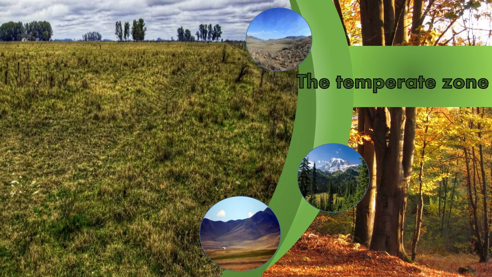
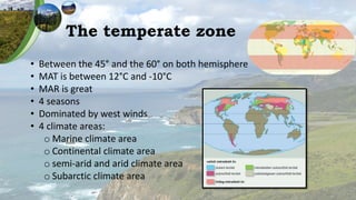
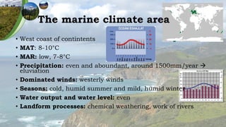
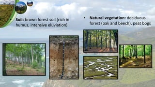
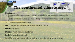
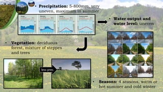
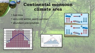
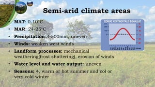
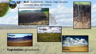
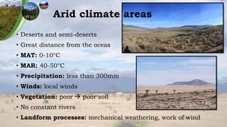
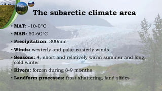
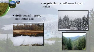
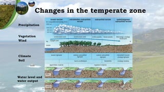
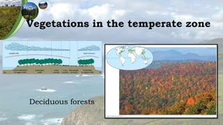
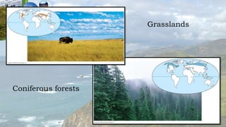
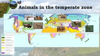
The temperate zone
• Between the 45° and the 60° on both hemisphere
• MAT is between 12°C and -10°C
• MAR is great
• 4 seasons
• Dominated by west winds
• 4 climate areas:
o Marine climate area
o Continental climate area
o semi-arid and arid climate area
o Subarctic climate area
The marine climate area
• West coast of contintents
• MAT: 8-10°C
• MAR: low, 7-8°C
• Precipitation: even and aboundant, around 1500mm/year 
eluviation
• Dominated winds: westerly winds
• Seasons: cold, humid summer and mild, humid winter
• Water output and water level: even
• Landform processes: chemical weathering, work of rivers
• Natural vegetation: deciduous
forest (oak and beech), peat bogs
• Soil: brown forest soil (rich in
humus, intensive eluviation)
The continental climate area
• Subtypes:
o Continental warm summer – mean temp.of the warmest month exceeds
20°C
o Continental cool summer – mean temp. of warmest month doesnt exceed
20°C
o Continental monsoon areas
• MAT: depends on the latitude, around 10°C
• MAR: 24-25°C
• Winds: west winds, cyclones
• Soil: brown forest soil
• Landform processes: chemical and mechanical weathering
• Vegetation: deciduous
forest, mixture of steppes
and trees
less prec.
• Seasons: 4 seasons, warm or
hot summer and cold winter
• Precipitation: 5-800mm, very
uneven, maximum in summer
• Water output and
water level: uneven
Continental monsoon
climate area
• East Asia
• very cold winter, warm summer
• abundant precipitation
Semi-arid climate areas
• MAT: 0-10°C
• MAR: 24-25°C
• Precipitation:3-500mm, uneven
• Winds: weaken west winds
• Landform processes: mechanical
weathering(frost shattering), erosion of winds
• Water level and water output: uneven
• Seasons: 4, warm or hot summer and col or
very cold winter
• Vegetation: grasslands
Steppe
Pampas
Prairie
• Soil: chernozem – black, high humus
content, slow eluviation
Arid climate areas
• Deserts and semi-deserts
• Great distance from the oceas
• MAT: 0-10°C
• MAR: 40-50°C
• Precipitation: less than 300mm
• Winds: local winds
• Vegetation: poor  poor soil
• No constant rivers
• Landform processes: mechanical weathering, work of wind
The subarctic climate area
• MAT: -10-0°C
• MAR: 50-60°C
• Precipitation: 300mm
• Winds: westerly and polar easterly winds
• Seasons: 4, short and relatively warm summer and long,
cold winter
• Rivers: forzen during 8-9 months
• Landform processes: frost shattering, land slides
• vegetation: coniferous forest,
taiga
• Soil: podzol – grey,
not fertile soil
Changes in the temperate zone
Precipitation
Vegetation
Wind
Climate
Soil
Water level and
water output
Vegetations in the temperate zone
Deciduous forests
Coniferous forests
Grasslands
Animals in the temperate zone

The temperate zone

  • 2.
    The temperate zone •Between the 45° and the 60° on both hemisphere • MAT is between 12°C and -10°C • MAR is great • 4 seasons • Dominated by west winds • 4 climate areas: o Marine climate area o Continental climate area o semi-arid and arid climate area o Subarctic climate area
  • 3.
    The marine climatearea • West coast of contintents • MAT: 8-10°C • MAR: low, 7-8°C • Precipitation: even and aboundant, around 1500mm/year  eluviation • Dominated winds: westerly winds • Seasons: cold, humid summer and mild, humid winter • Water output and water level: even • Landform processes: chemical weathering, work of rivers
  • 4.
    • Natural vegetation:deciduous forest (oak and beech), peat bogs • Soil: brown forest soil (rich in humus, intensive eluviation)
  • 5.
    The continental climatearea • Subtypes: o Continental warm summer – mean temp.of the warmest month exceeds 20°C o Continental cool summer – mean temp. of warmest month doesnt exceed 20°C o Continental monsoon areas • MAT: depends on the latitude, around 10°C • MAR: 24-25°C • Winds: west winds, cyclones • Soil: brown forest soil • Landform processes: chemical and mechanical weathering
  • 6.
    • Vegetation: deciduous forest,mixture of steppes and trees less prec. • Seasons: 4 seasons, warm or hot summer and cold winter • Precipitation: 5-800mm, very uneven, maximum in summer • Water output and water level: uneven
  • 7.
    Continental monsoon climate area •East Asia • very cold winter, warm summer • abundant precipitation
  • 8.
    Semi-arid climate areas •MAT: 0-10°C • MAR: 24-25°C • Precipitation:3-500mm, uneven • Winds: weaken west winds • Landform processes: mechanical weathering(frost shattering), erosion of winds • Water level and water output: uneven • Seasons: 4, warm or hot summer and col or very cold winter
  • 9.
    • Vegetation: grasslands Steppe Pampas Prairie •Soil: chernozem – black, high humus content, slow eluviation
  • 10.
    Arid climate areas •Deserts and semi-deserts • Great distance from the oceas • MAT: 0-10°C • MAR: 40-50°C • Precipitation: less than 300mm • Winds: local winds • Vegetation: poor  poor soil • No constant rivers • Landform processes: mechanical weathering, work of wind
  • 11.
    The subarctic climatearea • MAT: -10-0°C • MAR: 50-60°C • Precipitation: 300mm • Winds: westerly and polar easterly winds • Seasons: 4, short and relatively warm summer and long, cold winter • Rivers: forzen during 8-9 months • Landform processes: frost shattering, land slides
  • 12.
    • vegetation: coniferousforest, taiga • Soil: podzol – grey, not fertile soil
  • 13.
    Changes in thetemperate zone Precipitation Vegetation Wind Climate Soil Water level and water output
  • 14.
    Vegetations in thetemperate zone Deciduous forests
  • 15.
  • 16.
    Animals in thetemperate zone