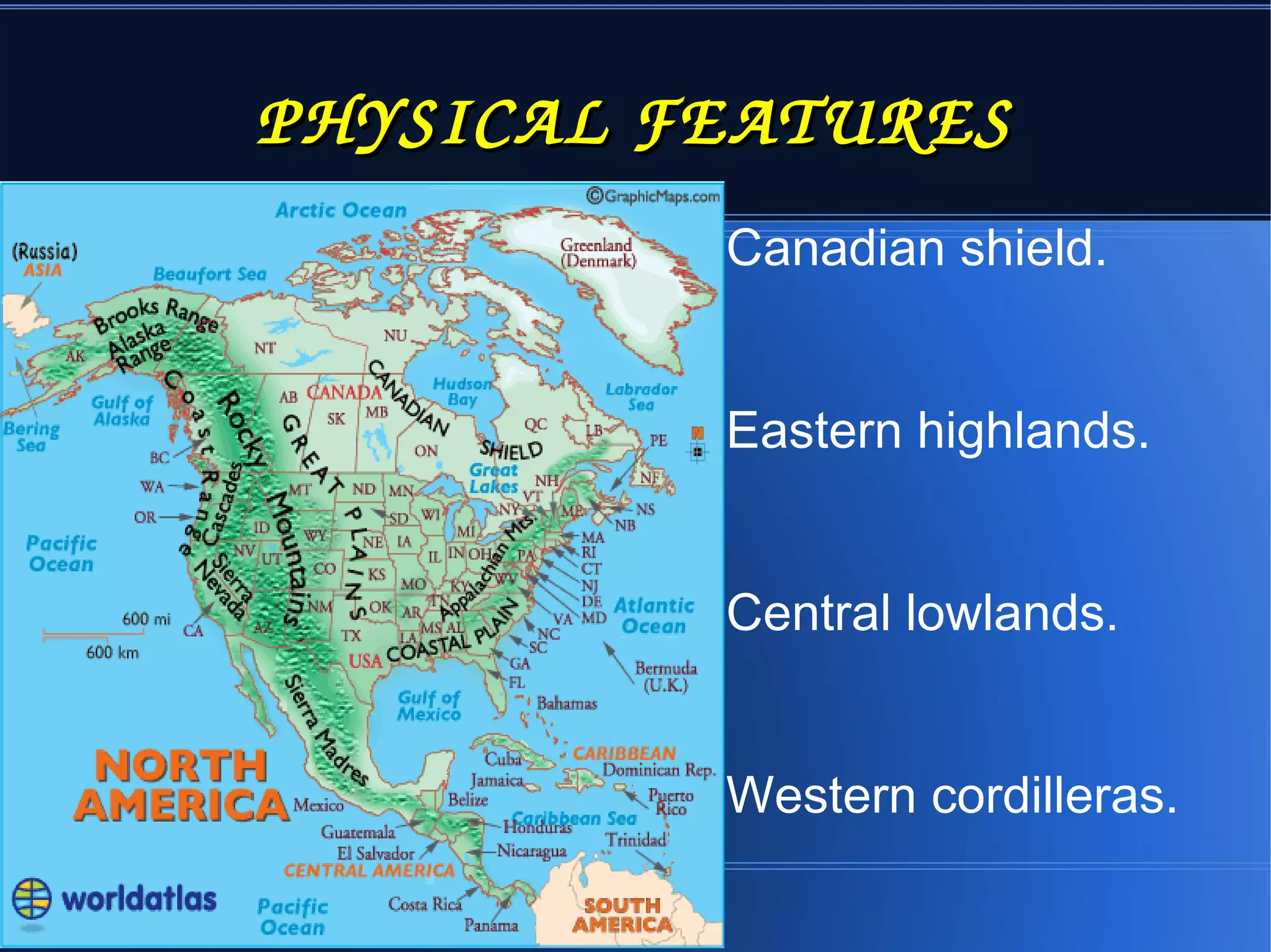
Presiding Officer Training module 2024 lok sabha elections
North america
1. NORTH AMERICNORTH AMERICA
North america is the
third largest continent .
It is 24 million square
km.
It extends from 7 degree
north to 85 degree north
latitude &
20degree west to 179
degree west longitude.
POLITICAL MAP PHYSICAL MAP
5. CANADIAN SHIELCANADIAN SHIELD
It is made up of very old,hard
rocks.
Many small rivers originate
from here and flow
in to the Hudson Bay.
Lake superior, lake
michigan,lake huron,lake erie
and lake ontario known as
five great lakes. River
st.Lawrence is an important
inland water way.
CANADIAN SHIELD
6. EASTERN HIGHLAND
It is also known as
appalachian mountains.
Its average height is
900m above mean sea
level.
The highest peak here is
mt.mitchell which is
2037 m high.
EASTERN HIGHLANDS
7. CENTRAL LOWLAND
THIS IS THE AGRICULTURE
ZONE OF NORTH AMERICA.
IT STRECHES 6000KM EAST TO
WEST IN THE SOUTH FROM
THE GULF OF MEXICO IN THE
SOUTH TO THE MACKENZIE
RIVER BASIN IN THE NORTH
THE MISSOURI AND
MISSISSIPPI RIVERS PROVIDE
THE SOUTHERN PARTS OF
THESE PLAINS WITH ALLUVIAL
DEPOSITS AND WATER SUPPLY.
8. THE WESTERN CORDILLERAS
THIS RANGES EXTEND FROM ALASKA
TO PANAMA.
THE MAXIMUM WIDTH: 1500km.
THE OTHER MOUNTAIN RANGES:
CASCADE RANGE, SIERRA NEVADA
AND SIERA MADRE.
HIGHEST PEAK: Mt.MCKINLEY
(6194m)
PLATEAU: COLUMBIA PLATEAU,
ALASKA PLATEAU AND
COLORADO PLATEAU
13. CLIMATE
A MAJOR PART OF NORTH
AMERICA LIES IN THE
TEMPARATE ZONE AND A VERY
SMALL PART IN THE FRIGID
ZONE AND THE TROPICS
THE FACTORS THAT
INFLUENCE THE CLIMATE ARE;
NEARNESS TO THE SEA
MOUNTAIN RANGES
OCEAN CURRENTS
14. CLIMATIC REGIONS AND
NATURAL VEGETATION.
1. TUNDRA REGION
2. THE TAIGA REGION
3. THE TEMPARATE EAST MARGIN REGION
4. COOL TEMPERATE WESTERN MARGINS
5. THE PRAIRIE GRASSLANDS
6. THE MEDITERRANEAN TYPE OF CLIMATE
7. HOT DESERT
8. TROPICAL RAIN FORESTS
15. TUNDRA REGION
This region which
incudes the Hudson
bay is situated to the
north of the artic
circle
(661/2degree north).
Severe cold and a
long winter
TUNDRA REGION
16. THE TAIGA REGION
Extending from New
Foundland in the east to
Alaska in the
west,coniferous forests can
be seen
Warm and short winters
Main occupation here is
lumbering and fur trade
TAIGA REGION
17. THE TEMPERATE EAST MARGIN
REGION
It is located to the east of the great
lakes and the Appalachian
mountains.
Due to the influence of the Cold
Labrador Current in the west
winters are very cold.
Rain is experienced here in
summers.In south the summers
are very hot and winters are
mild.The coastal region
experiences cyclonic winds like
Hurricane and Tornado.
18. COOL TEMPERATE WESTERN
MARGIN
It extends from the north of
California to Alaska.
The warm Alaska current
that flows through these
shores make the summers
hot and winters cool.
The proximity to the rocky
mountains helps in ensuring
heavy rain fall in the region.
Coniferous forests are
mostly found here.
19. THE PRAIRIE GRASLANDS
It extends from the south of Taiga,
the region between the Great lakes
and the rockies, to the missourimississippi
basin.
Short grass is the vegetation seen
here.
To the east of 100degree west
meridian, where there is high
rainfall,the grasslands are extensively
cleared for the cultivation of
wheat,corn and cotton.
This area is known as the granary of
wheat.
GRASSLANDS
OF NORTH AMERICA
20. THE MEDITERRANEAN TYPE OF
CLIMATE
This climate is experienced in
central California which is
located in the western coast of
North America.
This western climatic region
lies between 30degree north
and 40degree north latitudes.
It rains here in winter.
Fruits like orange and grapes
grown here.
21. HOT DESERTS
This region is on the south
western part of North
America,on the east of the
rocky mountain range.
Summers are very hot and
winters are very cold.
It rains very little in this region
and only thorny bushes and a
variety of grasses are mainly
found here.
NORTH AMERICAN
HOT DESERTS
22. TROPICAL RAIN FORESTS
This forests is found
in Central America and
the west Indies.
This region is
characterized by
heavy rainfall and high
temperature.
23. LIFE OF THE PEOPLE
1. AGRICULTURE
2. DAIRY FARMING
3. FISHING
4. INDUSTRY
24. AGRICULTURE
The main agricultral area of the
continent is the central plains.
Fertile soil,availability of
water,suitable climate, vast
agricultural
lands,mechanisation,all make
this area ideal for the
advancement in
agriculture.Wheat,corn,oats,bar
ley etc are the major crops.
25. DAIRY FARMING
One of the main occupation of the
North American people.The vast
grasslands here is conducive to
rearing cattle.In the north eastern
parts of the United States of
America and in the adjacent
regions of Canada,it is seen on a
large scale.In the dry areas of the
rockies, sheep are reared for
wool and meat, pigs for meat,
fowl for meat and eggs.
DAIRY
DAIRY FARM
26. FISHING
North America has oceans on
three sides.
In the shallower areas of the
Pacific and the Atlantic oceans a
lot of plankton is seen,which
makes a favourable situation for
the availability of fish.The fishing
centres in the Atlantic are St.Pier
bank,Sable Island bank,Browns
bank and Georges bank.
FISHING
27. INDUSTRY
The large deposits of minerals and ores
especially those which are energy
resources, and the availability of
agricultural and forest products have
helped America in industrial development.
The willingness of the American people
to work hard and their entrepreneurial
inclinations are reasons flourishing
industries.
28. IMPORTANT INDUSTRIES
The important industries
here are iron ore
smelting,automobile
industry,ship
building,production of
agricultural machinery,
cotton textiles,woollen
textiles,paper,fertilizer,pa
int, electrical and
electronics products,
computer hardware and
29. പട്ടിക പൂർതർ്തർ ിർയർ ാർകർ്കർ ുർകർ
വൻ
കരകൻ
നദികൻ പൻവൻ്വൻ
തനിരക
ൻ
പീഠഭൂമി
കൻ
സമതല
ങങ്ൻ
പുൻ
േമടുകൻ
മരുഭൂമി
കൻ
ആസ്ട്േരല
ിിയ
വ.അേമരി
ക്ക
ത െി.അേമരിക്
ക