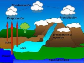
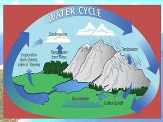
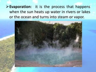
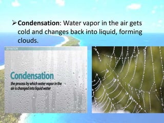
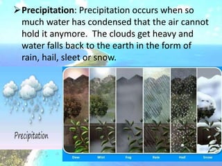
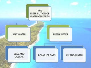
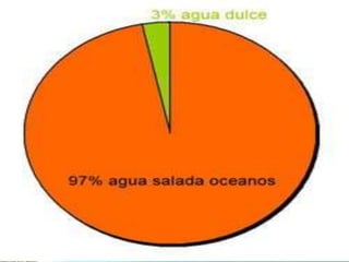
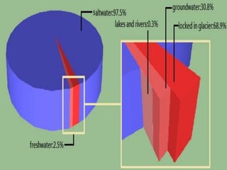
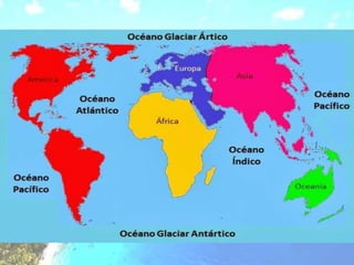
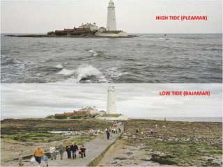
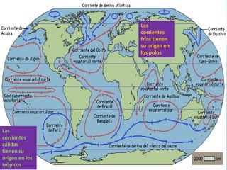
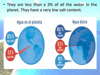
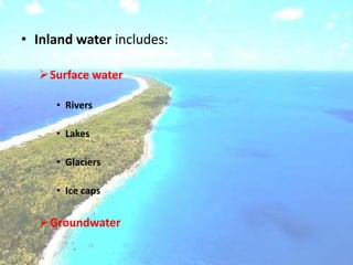
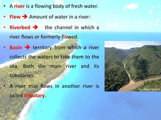
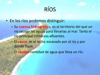
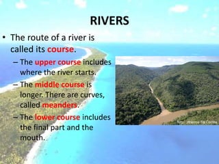
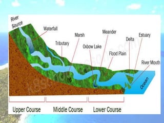
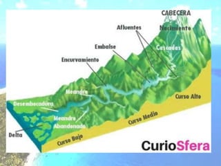
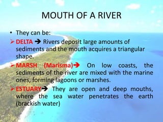
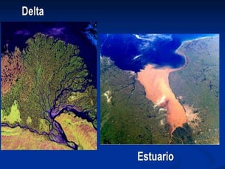
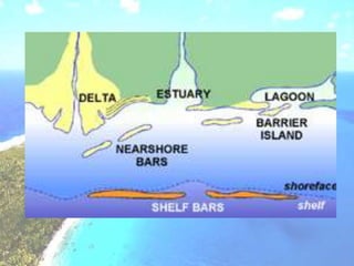
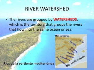
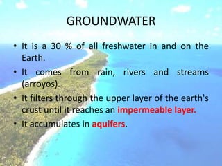
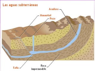
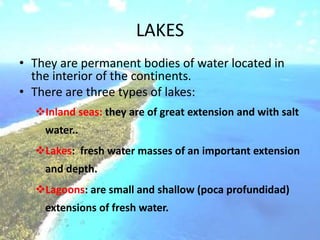
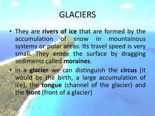
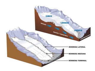
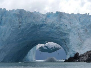
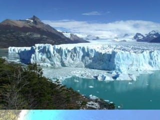
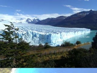
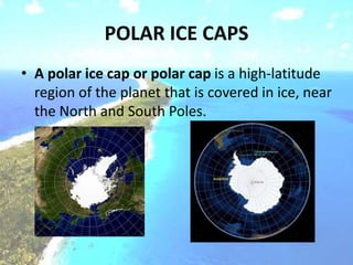
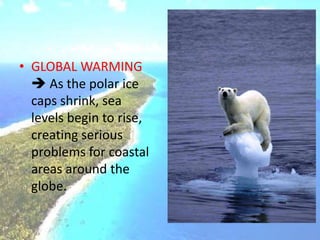
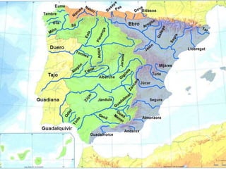
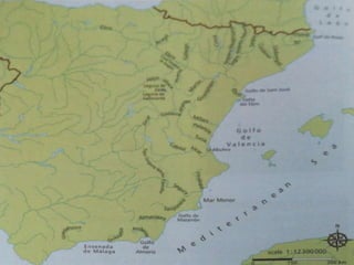
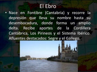
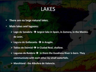
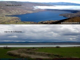
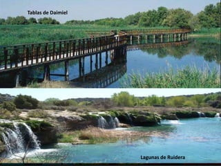
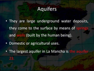
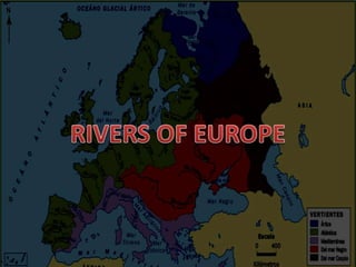
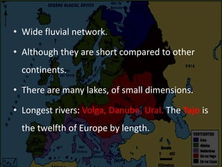
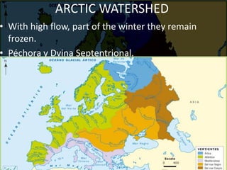
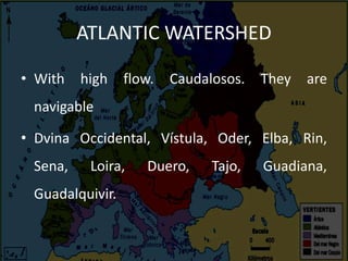
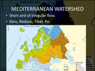
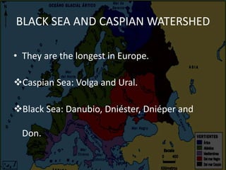
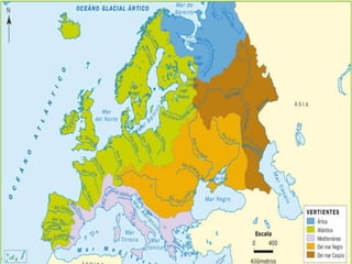
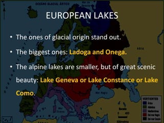
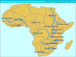
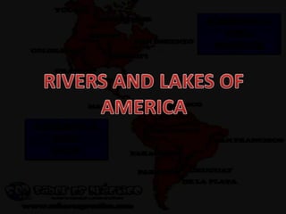
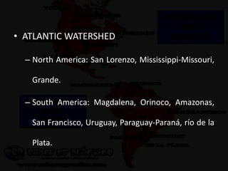
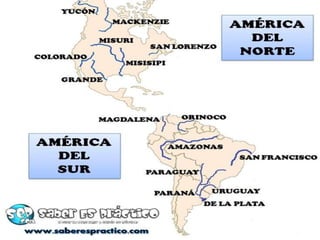
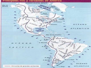
HYDROSPHERE
• The word hydrosphere refers to all the water
on the planet, in all three states (solid, liquid
or gas). It can be in oceans, seas, rivers, lakes,
glaciers…
• More than a 70% of the surface of Earth’s
surface is covered by water.
WATER CYCLE
• The Earth has a limited amount of water. The
amount of water that exists on Earth is
always constant.
• That water keeps going around and around,
water is in continuous movement:
hydrological cycle or water cycle.
Evaporation: it is the process that happens
when the sun heats up water in rivers or lakes
or the ocean and turns into steam or vapor.
Condensation: Water vapor in the air gets
cold and changes back into liquid, forming
clouds.
Precipitation: Precipitation occurs when so
much water has condensed that the air cannot
hold it anymore. The clouds get heavy and
water falls back to the earth in the form of
rain, hail, sleet or snow.
THE
DISTRIBUTION OF
WATER ON EARTH
SALT WATER
SEAS AND
OCEANS
FRESH WATER
POLAR ICE CAPS INLAND WATER
• Most water in the Earth's atmosphere and
crust comes from the world ocean's saline
seawater, a 97,5 %, while freshwater
accounts for only 2.5 % of the total.
• Salt water is a mixture of mineral salts; the
most common component is sodium chloride
(common salt).
Oceans  bodies of water that surround
continents.
Seas  form parts of oceans. They are
smaller.
OCEANS
• Pacific
• Atlantic
• Indian
• Arctic
• Antarctic
• Oceans and seas move and change all the time in
a variety of ways:
Waves occur on the surface of the water. They are
mainly caused by the wind and can vary in strength.
Tides are the regular movements of the seas in which
the sea levels rise and fall. This is caused by the
gravitational force of the Sun and the Moon.
Ocean currents are horizontal movements of water
within seas and currents.
MOVIMIENTOS DE LAS AGUAS MARINAS
• LAS OLAS  movimientos ondulares de la
superficie marina producidos por los vientos.
• LAS MAREAS  movimientos periódicos de
ascenso y descenso de la superficie de las aguas
marinas. La atracción gravitacional del Sol y la Luna
las provocan.
– Marea baja: bajamar.
– Marea alta: pleamar.
• LAS CORRIENTES MARINAS  desplazamientos de
agua marina en el interior de las aguas oceánicas.
– Corrientes frías
– Corrientes calientes
WAVES
HIGH TIDE (PLEAMAR)
LOW TIDE (BAJAMAR)
Las
corrientes
frías tienen
su origen en
los polos
Las
corrientes
cálidas
tienen su
origen en los
trópicos
• They are less than a 3% of all the water in the
planet. They have a very low salt content.
• Inland water includes:
Surface water
• Rivers
• Lakes
• Glaciers
• Ice caps
Groundwater
• A river is a flowing body of fresh water.
• Flow  Amount of water in a river:
• Riverbed  the channel in which a
river flows or formerly flowed.
• Basin  territory from which a river
collects the waters to take them to the
sea. Both the main river and its
tributaries.
• A river that flows in another river is
called tributary.
RÍOS
• En los ríos podemos distinguir:
– Su cuenca hidrográfica, es el territorio del que un
río recoge las aguas para llevarlas al mar. Tanto el
río principal como sus afluentes.
– El cauce: es el lecho excavado por el río y por
donde fluye.
– El caudal: cantidad de agua que lleva un río.
RIVERS
• The route of a river is
called its course.
– The upper course includes
where the river starts.
– The middle course is
longer. There are curves,
called meanders.
– The lower course includes
the final part and the
mouth.
MOUTH OF A RIVER
• They can be:
DELTA  Rivers deposit large amounts of
sediments and the mouth acquires a triangular
shape.
MARSH (Marisma) On low coasts, the
sediments of the river are mixed with the marine
ones, forming lagoons or marshes.
ESTUARY They are open and deep mouths,
where the sea water penetrates the earth
(brackish water)
RIVER WATERSHED
• The rivers are grouped by WATERSHEDS,
which is the territory that groups the rivers
that flow into the same ocean or sea.
Ríos de la vertiente mediterránea
GROUNDWATER
• It is a 30 % of all freshwater in and on the
Earth.
• It comes from rain, rivers and streams
(arroyos).
• It filters through the upper layer of the earth's
crust until it reaches an impermeable layer.
• It accumulates in aquifers.
LAKES
• They are permanent bodies of water located in
the interior of the continents.
• There are three types of lakes:
Inland seas: they are of great extension and with salt
water..
Lakes: fresh water masses of an important extension
and depth.
Lagoons: are small and shallow (poca profundidad)
extensions of fresh water.
GLACIERS
• They are rivers of ice that are formed by the
accumulation of snow in mountainous
systems or polar areas. Its travel speed is very
small. They erode the surface by dragging
sediments called moraines.
• In a glacier we can distinguish the circus (it
would be the birth, a large accumulation of
ice), the tongue (channel of the glacier) and
the front (front of a glacier)
POLAR ICE CAPS
• A polar ice cap or polar cap is a high-latitude
region of the planet that is covered in ice, near
the North and South Poles.
• GLOBAL WARMING
 As the polar ice
caps shrink, sea
levels begin to rise,
creating serious
problems for coastal
areas around the
globe.
• The Spanish rivers are, in general, short and of
a scarce and irregular flow.
• In the Iberian Peninsula there are three
watersheds:
– The Cantabrian.
– The Atlantic.
– The Mediterranean.
CANTABRIAN WATERSHED
• The rivers in this region are short, and empty
into the Cantabrian Sea. They have a large
flow because the area receives a lot of
precipitation. These rivers have a steep
gradient because the Cordillera Cantábrica is
close to the sea.
• They stand out: the Bidasoa, the Nervión, the
Pas, the Besaya, the Nalón, Narcea and the
Eo.
ATLANTIC WATERSHED
• Most of the rivers on
the Peninsula empty
into the Atlantic
Ocean. The reason for
this is that the Meseta
is very large and slopes
to the west.
ATLANTIC WATERSHED
Galician rivers
With high flow. They form inlets in their mouths.
 Tambre, Ulla, Miño, Sil.
Rivers that cross the Meseta.
 They have large river basins and very long
courses.
 Duero, Tajo, Guadiana.
Andalusian rivers
Guadalquivir, Odiel, Tinto y Guadalete.
El Duero
• Nace en los Picos de Urbión, en el Sistema
Ibérico y recorre la submeseta Norte. Recibe
sus afluentes del Sistema Central y de la
Cordillera Cantábrica. Desemboca en Oporto
(Portugal).
El Tajo
• Nace en los Montes Universales, también en
el Sistema Ibérico. Recorre la Submeseta Sur,
entre el Sistema Central y los Montes de
Toledo. Desemboca en Lisboa (Portugal).
Puente de Alcántara sobre el río Tajo
El Guadiana
• Es el de menor caudal de los grandes ríos de la
península.
• Nace en las Lagunas de Ruidera y recorre las
llanuras manchegas, entre los Montes de
Toledo y Sierra Morena. Desemboca en
Ayamonte (Huelva).
Lagunas de Ruidera
El Guadalquivir
• Nace en la sierra de Cazorla, en los Sistemas
Béticos, recorre la depresión que lleva su
nombre. Su afluente más importante es el
Genil. Desemboca en Sanlúcar de Barrameda,
formando un conjunto de marismas.
MEDITERRANEAN WATERSHED
• Except for the Ebro, the rivers of the
Mediterranean watershed are short and have
a low flow.
Catalan rivers  Ter and Llobregat.
Rivers of Levante  Turia, Júcar and Segura.
Andalusian rivers  Guadalhorte and
Andarax.
El Ebro
• Nace en Fontibre (Cantabria) y recorre la
depresión que lleva su nombre hasta su
desembocadura, donde forma un amplio
delta. Recibe aportes de la Cordillera
Cantábrica, Los Pirineos y el Sistema Ibérico.
Afluentes destacados: Segre y el Gállego.
LAKES
• There are no large natural lakes.
• Main lakes and lagoons:
 Lago de Sanabria  largest lake in Spain, in Zamora, in the Montes
de León.
 Laguna de Gallocanta  in Aragón.
 Tablas de Daimiel  in Ciudad Real, shallow.
 Lagunas de Ruidera  in them the Guadiana River is born. They
communicate with each other by small waterfalls.
 Marshland : the Albufera de Valencia.
Laguna de Sanabria
Laguna de Gallocanta
Tablas de Daimiel
Lagunas de Ruidera
Aquifers
• They are large underground water deposits,
they come to the surface by means of springs
and wells (built by the human being).
• Domestic or agricultural uses.
• The largest aquifer in La Mancha is the aquifer
23.
• Wide fluvial network.
• Although they are short compared to other
continents.
• There are many lakes, of small dimensions.
• Longest rivers: Volga, Danube, Ural. The Tajo is
the twelfth of Europe by length.
ARCTIC WATERSHED
• With high flow, part of the winter they remain
frozen.
• Péchora y Dvina Septentrional.
ATLANTIC WATERSHED
• With high flow. Caudalosos. They are
navigable
• Dvina Occidental, Vístula, Oder, Elba, Rin,
Sena, Loira, Duero, Tajo, Guadiana,
Guadalquivir.
MEDITERRANEAN WATERSHED
• Short and of irregular flow.
• Ebro, Ródano, Tíber, Po.
BLACK SEA AND CASPIAN WATERSHED
• They are the longest in Europe.
Caspian Sea: Volga and Ural.
Black Sea: Danubio, Dniéster, Dniéper and
Don.
EUROPEAN LAKES
• The ones of glacial origin stand out.
• The biggest ones: Ladoga and Onega.
• The alpine lakes are smaller, but of great scenic
beauty: Lake Geneva or Lake Constance or Lake
Como.
• ATLANTIC WATERSHED
– Senegal, Níger, Congo y Orange.
• INDIAN WATERSHED
– Limpopo, Zambeze
• MEDITERRANEAN WATERSHED
– Nilo (the longest in the world).
AFRICAN LAKES
• The most important
ones are in the Rift
Valley.
• Victoria, Tanganica,
Malawy.
• Out of the Rift Valley:
Chad, Volta.
• ATLANTIC WATERSHED
– North America: San Lorenzo, Mississippi-Missouri,
Grande.
– South America: Magdalena, Orinoco, Amazonas,
San Francisco, Uruguay, Paraguay-Paraná, río de la
Plata.
• PACIFIC WATERSHED
– North America: Yukón, Colorado
• ARCTIC WATERSHED
– MacKenzie
• LAKES
– The longest group of lakes in the world  The
Great Lakes (Grandes Lagos).
– Grandes Lagos: Superior, Míchigan, Hurón, Erie y
Ontario.
– Central America: Nicaragua.
– South America: Titicaca.
• ARCTIC WATERSHED: Obi, Yenisei, Lena.
• PACIFIC WATERSHED: Amur, Huang-Ho (Amarillo),
Yangtsé Kian(Azul), Mekong.
• INDIAN WATERSHED: Brahmaputra, Ganges, Indo,
Tigris, Eufrates.
• LAKES: mar Caspio, mar de Aral, lago Baikal, Balkhash.
• They are very scarce.
• Only in Australia are two important rivers: el
Darling y el Murray.

THE HYDROSPHERE

  • 2.
    HYDROSPHERE • The wordhydrosphere refers to all the water on the planet, in all three states (solid, liquid or gas). It can be in oceans, seas, rivers, lakes, glaciers… • More than a 70% of the surface of Earth’s surface is covered by water.
  • 3.
    WATER CYCLE • TheEarth has a limited amount of water. The amount of water that exists on Earth is always constant. • That water keeps going around and around, water is in continuous movement: hydrological cycle or water cycle.
  • 6.
    Evaporation: it isthe process that happens when the sun heats up water in rivers or lakes or the ocean and turns into steam or vapor.
  • 7.
    Condensation: Water vaporin the air gets cold and changes back into liquid, forming clouds.
  • 8.
    Precipitation: Precipitation occurswhen so much water has condensed that the air cannot hold it anymore. The clouds get heavy and water falls back to the earth in the form of rain, hail, sleet or snow.
  • 9.
    THE DISTRIBUTION OF WATER ONEARTH SALT WATER SEAS AND OCEANS FRESH WATER POLAR ICE CAPS INLAND WATER
  • 15.
    • Most waterin the Earth's atmosphere and crust comes from the world ocean's saline seawater, a 97,5 %, while freshwater accounts for only 2.5 % of the total. • Salt water is a mixture of mineral salts; the most common component is sodium chloride (common salt). Oceans  bodies of water that surround continents. Seas  form parts of oceans. They are smaller.
  • 16.
    OCEANS • Pacific • Atlantic •Indian • Arctic • Antarctic
  • 18.
    • Oceans andseas move and change all the time in a variety of ways: Waves occur on the surface of the water. They are mainly caused by the wind and can vary in strength. Tides are the regular movements of the seas in which the sea levels rise and fall. This is caused by the gravitational force of the Sun and the Moon. Ocean currents are horizontal movements of water within seas and currents.
  • 19.
    MOVIMIENTOS DE LASAGUAS MARINAS • LAS OLAS  movimientos ondulares de la superficie marina producidos por los vientos. • LAS MAREAS  movimientos periódicos de ascenso y descenso de la superficie de las aguas marinas. La atracción gravitacional del Sol y la Luna las provocan. – Marea baja: bajamar. – Marea alta: pleamar. • LAS CORRIENTES MARINAS  desplazamientos de agua marina en el interior de las aguas oceánicas. – Corrientes frías – Corrientes calientes
  • 20.
  • 21.
  • 22.
    Las corrientes frías tienen su origenen los polos Las corrientes cálidas tienen su origen en los trópicos
  • 24.
    • They areless than a 3% of all the water in the planet. They have a very low salt content.
  • 25.
    • Inland waterincludes: Surface water • Rivers • Lakes • Glaciers • Ice caps Groundwater
  • 26.
    • A riveris a flowing body of fresh water. • Flow  Amount of water in a river: • Riverbed  the channel in which a river flows or formerly flowed. • Basin  territory from which a river collects the waters to take them to the sea. Both the main river and its tributaries. • A river that flows in another river is called tributary.
  • 27.
    RÍOS • En losríos podemos distinguir: – Su cuenca hidrográfica, es el territorio del que un río recoge las aguas para llevarlas al mar. Tanto el río principal como sus afluentes. – El cauce: es el lecho excavado por el río y por donde fluye. – El caudal: cantidad de agua que lleva un río.
  • 28.
    RIVERS • The routeof a river is called its course. – The upper course includes where the river starts. – The middle course is longer. There are curves, called meanders. – The lower course includes the final part and the mouth.
  • 31.
    MOUTH OF ARIVER • They can be: DELTA  Rivers deposit large amounts of sediments and the mouth acquires a triangular shape. MARSH (Marisma) On low coasts, the sediments of the river are mixed with the marine ones, forming lagoons or marshes. ESTUARY They are open and deep mouths, where the sea water penetrates the earth (brackish water)
  • 34.
    RIVER WATERSHED • Therivers are grouped by WATERSHEDS, which is the territory that groups the rivers that flow into the same ocean or sea. Ríos de la vertiente mediterránea
  • 35.
    GROUNDWATER • It isa 30 % of all freshwater in and on the Earth. • It comes from rain, rivers and streams (arroyos). • It filters through the upper layer of the earth's crust until it reaches an impermeable layer. • It accumulates in aquifers.
  • 37.
    LAKES • They arepermanent bodies of water located in the interior of the continents. • There are three types of lakes: Inland seas: they are of great extension and with salt water.. Lakes: fresh water masses of an important extension and depth. Lagoons: are small and shallow (poca profundidad) extensions of fresh water.
  • 38.
    GLACIERS • They arerivers of ice that are formed by the accumulation of snow in mountainous systems or polar areas. Its travel speed is very small. They erode the surface by dragging sediments called moraines. • In a glacier we can distinguish the circus (it would be the birth, a large accumulation of ice), the tongue (channel of the glacier) and the front (front of a glacier)
  • 43.
    POLAR ICE CAPS •A polar ice cap or polar cap is a high-latitude region of the planet that is covered in ice, near the North and South Poles.
  • 44.
    • GLOBAL WARMING As the polar ice caps shrink, sea levels begin to rise, creating serious problems for coastal areas around the globe.
  • 47.
    • The Spanishrivers are, in general, short and of a scarce and irregular flow. • In the Iberian Peninsula there are three watersheds: – The Cantabrian. – The Atlantic. – The Mediterranean.
  • 48.
    CANTABRIAN WATERSHED • Therivers in this region are short, and empty into the Cantabrian Sea. They have a large flow because the area receives a lot of precipitation. These rivers have a steep gradient because the Cordillera Cantábrica is close to the sea. • They stand out: the Bidasoa, the Nervión, the Pas, the Besaya, the Nalón, Narcea and the Eo.
  • 51.
    ATLANTIC WATERSHED • Mostof the rivers on the Peninsula empty into the Atlantic Ocean. The reason for this is that the Meseta is very large and slopes to the west.
  • 52.
    ATLANTIC WATERSHED Galician rivers Withhigh flow. They form inlets in their mouths.  Tambre, Ulla, Miño, Sil. Rivers that cross the Meseta.  They have large river basins and very long courses.  Duero, Tajo, Guadiana. Andalusian rivers Guadalquivir, Odiel, Tinto y Guadalete.
  • 54.
    El Duero • Naceen los Picos de Urbión, en el Sistema Ibérico y recorre la submeseta Norte. Recibe sus afluentes del Sistema Central y de la Cordillera Cantábrica. Desemboca en Oporto (Portugal).
  • 55.
    El Tajo • Naceen los Montes Universales, también en el Sistema Ibérico. Recorre la Submeseta Sur, entre el Sistema Central y los Montes de Toledo. Desemboca en Lisboa (Portugal). Puente de Alcántara sobre el río Tajo
  • 56.
    El Guadiana • Esel de menor caudal de los grandes ríos de la península. • Nace en las Lagunas de Ruidera y recorre las llanuras manchegas, entre los Montes de Toledo y Sierra Morena. Desemboca en Ayamonte (Huelva). Lagunas de Ruidera
  • 57.
    El Guadalquivir • Naceen la sierra de Cazorla, en los Sistemas Béticos, recorre la depresión que lleva su nombre. Su afluente más importante es el Genil. Desemboca en Sanlúcar de Barrameda, formando un conjunto de marismas.
  • 58.
    MEDITERRANEAN WATERSHED • Exceptfor the Ebro, the rivers of the Mediterranean watershed are short and have a low flow. Catalan rivers  Ter and Llobregat. Rivers of Levante  Turia, Júcar and Segura. Andalusian rivers  Guadalhorte and Andarax.
  • 61.
    El Ebro • Naceen Fontibre (Cantabria) y recorre la depresión que lleva su nombre hasta su desembocadura, donde forma un amplio delta. Recibe aportes de la Cordillera Cantábrica, Los Pirineos y el Sistema Ibérico. Afluentes destacados: Segre y el Gállego.
  • 62.
    LAKES • There areno large natural lakes. • Main lakes and lagoons:  Lago de Sanabria  largest lake in Spain, in Zamora, in the Montes de León.  Laguna de Gallocanta  in Aragón.  Tablas de Daimiel  in Ciudad Real, shallow.  Lagunas de Ruidera  in them the Guadiana River is born. They communicate with each other by small waterfalls.  Marshland : the Albufera de Valencia.
  • 63.
  • 64.
  • 65.
    Aquifers • They arelarge underground water deposits, they come to the surface by means of springs and wells (built by the human being). • Domestic or agricultural uses. • The largest aquifer in La Mancha is the aquifer 23.
  • 67.
    • Wide fluvialnetwork. • Although they are short compared to other continents. • There are many lakes, of small dimensions. • Longest rivers: Volga, Danube, Ural. The Tajo is the twelfth of Europe by length.
  • 68.
    ARCTIC WATERSHED • Withhigh flow, part of the winter they remain frozen. • Péchora y Dvina Septentrional.
  • 69.
    ATLANTIC WATERSHED • Withhigh flow. Caudalosos. They are navigable • Dvina Occidental, Vístula, Oder, Elba, Rin, Sena, Loira, Duero, Tajo, Guadiana, Guadalquivir.
  • 71.
    MEDITERRANEAN WATERSHED • Shortand of irregular flow. • Ebro, Ródano, Tíber, Po.
  • 72.
    BLACK SEA ANDCASPIAN WATERSHED • They are the longest in Europe. Caspian Sea: Volga and Ural. Black Sea: Danubio, Dniéster, Dniéper and Don.
  • 74.
    EUROPEAN LAKES • Theones of glacial origin stand out. • The biggest ones: Ladoga and Onega. • The alpine lakes are smaller, but of great scenic beauty: Lake Geneva or Lake Constance or Lake Como.
  • 77.
    • ATLANTIC WATERSHED –Senegal, Níger, Congo y Orange. • INDIAN WATERSHED – Limpopo, Zambeze • MEDITERRANEAN WATERSHED – Nilo (the longest in the world).
  • 79.
    AFRICAN LAKES • Themost important ones are in the Rift Valley. • Victoria, Tanganica, Malawy. • Out of the Rift Valley: Chad, Volta.
  • 82.
    • ATLANTIC WATERSHED –North America: San Lorenzo, Mississippi-Missouri, Grande. – South America: Magdalena, Orinoco, Amazonas, San Francisco, Uruguay, Paraguay-Paraná, río de la Plata.
  • 84.
    • PACIFIC WATERSHED –North America: Yukón, Colorado
  • 85.
    • ARCTIC WATERSHED –MacKenzie • LAKES – The longest group of lakes in the world  The Great Lakes (Grandes Lagos). – Grandes Lagos: Superior, Míchigan, Hurón, Erie y Ontario. – Central America: Nicaragua. – South America: Titicaca.
  • 90.
    • ARCTIC WATERSHED:Obi, Yenisei, Lena. • PACIFIC WATERSHED: Amur, Huang-Ho (Amarillo), Yangtsé Kian(Azul), Mekong. • INDIAN WATERSHED: Brahmaputra, Ganges, Indo, Tigris, Eufrates. • LAKES: mar Caspio, mar de Aral, lago Baikal, Balkhash.
  • 93.
    • They arevery scarce. • Only in Australia are two important rivers: el Darling y el Murray.