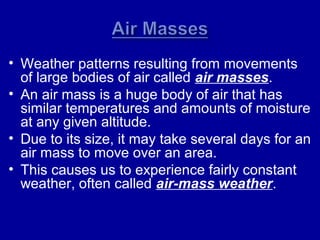
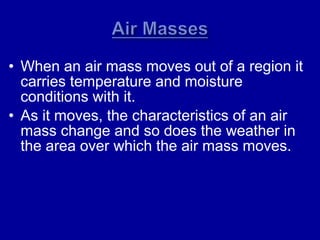
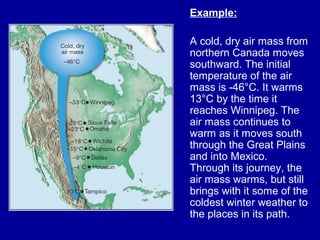
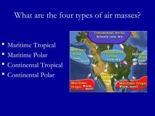
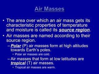
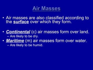
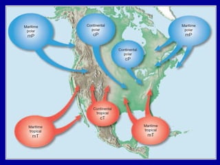
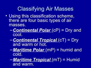
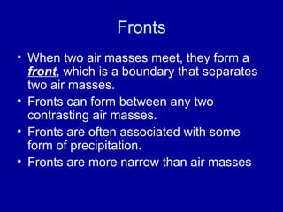
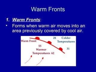
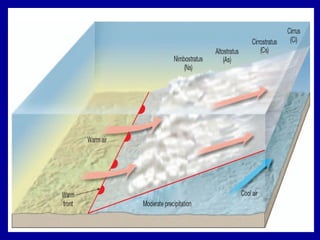
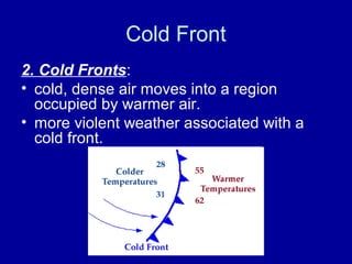
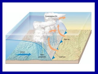
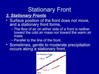
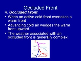
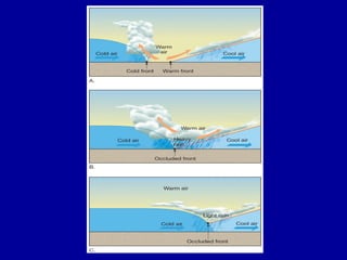
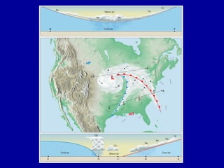
Air masses
and fronts
• Weather patterns resulting from movements
of large bodies of air called air masses.
• An air mass is a huge body of air that has
similar temperatures and amounts of moisture
at any given altitude.
• Due to its size, it may take several days for an
air mass to move over an area.
• This causes us to experience fairly constant
weather, often called air-mass weather.
• When an air mass moves out of a region it
carries temperature and moisture
conditions with it.
• As it moves, the characteristics of an air
mass change and so does the weather in
the area over which the air mass moves.
Example:
A cold, dry air mass from
northern Canada moves
southward. The initial
temperature of the air
mass is -46°C. It warms
13°C by the time it
reaches Winnipeg. The
air mass continues to
warm as it moves south
through the Great Plains
and into Mexico.
Through its journey, the
air mass warms, but still
brings with it some of the
coldest winter weather to
the places in its path.
What are the four types of air masses?
 Maritime Tropical
 Maritime Polar
 Continental Tropical
 Continental Polar
• The area over which an air mass gets its
characteristic properties of temperature
and moisture is called its source region.
• Air masses are named according to their
source region.
– Polar (P) air masses form at high altitudes
towards Earth’s poles.
• Polar air masses are cold.
– Air masses that form at low latitudes are
tropical (T) air masses.
• Tropical air masses are warm.
• Air masses are also classified according to
the surface over which they form.
• Continental (c) air masses form over land.
– Are likely to be dry.
• Maritime (m) air masses form over water.
– Are likely to be humid.
Classifying Air Masses
• Using this classification scheme,
there are four basic types of air
masses.
–Continental Polar (cP) = Dry and
cool.
–Continental Tropical (cT) = Dry
and warm or hot.
–Maritime Polar (mP) = humid and
cold.
–Maritime Tropical (mT) = Humid
and warm.
Fronts
Fronts
• When two air masses meet, they form a
front, which is a boundary that separates
two air masses.
• Fronts can form between any two
contrasting air masses.
• Fronts are often associated with some
form of precipitation.
• Fronts are more narrow than air masses
Types of Fronts
• Fronts are classified according to the
temperature of the advancing front.
• There are four types
– Warm
– Cold
– Stationary
– Occluded
Warm Fronts
1. Warm Fronts:
• Forms when warm air moves into an
area previously covered by cool air.
Warm Front
• Produce light to moderate
precipitation over a large area for an
extended period
• A gradual increase in temperature
• A wind shift from the east to the
southwest
Cold Front
2. Cold Fronts:
• cold, dense air moves into a region
occupied by warmer air.
• more violent weather associated with a
cold front.
Cold Front
• Heavy downpours and gusty winds.
• Once the cold front passes,
temperatures drop and wind shifts.
• The weather behind a cold front is
dominated by a cold air mass, so, the
weather clears soon after it passes.
Stationary Front
3. Stationary Fronts:
• Surface position of the front does not move,
and a stationary front forms.
– The flow of air on either side of a front is neither
toward the cold air mass nor toward the warm air
mass
– Parallel to the line of the front.
• Sometimes, gentle to moderate precipitation
occurs along a stationary front.
Occluded Front
4. Occluded Front:
• When an active cold front overtakes a
warm front
• Advancing cold air wedges the warm
front upward
• The weather associated with an
occluded front is generally complex.
Air masses and fronts

Air masses and fronts

  • 1.
  • 2.
    • Weather patternsresulting from movements of large bodies of air called air masses. • An air mass is a huge body of air that has similar temperatures and amounts of moisture at any given altitude. • Due to its size, it may take several days for an air mass to move over an area. • This causes us to experience fairly constant weather, often called air-mass weather.
  • 3.
    • When anair mass moves out of a region it carries temperature and moisture conditions with it. • As it moves, the characteristics of an air mass change and so does the weather in the area over which the air mass moves.
  • 4.
    Example: A cold, dryair mass from northern Canada moves southward. The initial temperature of the air mass is -46°C. It warms 13°C by the time it reaches Winnipeg. The air mass continues to warm as it moves south through the Great Plains and into Mexico. Through its journey, the air mass warms, but still brings with it some of the coldest winter weather to the places in its path.
  • 5.
    What are thefour types of air masses?  Maritime Tropical  Maritime Polar  Continental Tropical  Continental Polar
  • 6.
    • The areaover which an air mass gets its characteristic properties of temperature and moisture is called its source region. • Air masses are named according to their source region. – Polar (P) air masses form at high altitudes towards Earth’s poles. • Polar air masses are cold. – Air masses that form at low latitudes are tropical (T) air masses. • Tropical air masses are warm.
  • 7.
    • Air massesare also classified according to the surface over which they form. • Continental (c) air masses form over land. – Are likely to be dry. • Maritime (m) air masses form over water. – Are likely to be humid.
  • 9.
    Classifying Air Masses •Using this classification scheme, there are four basic types of air masses. –Continental Polar (cP) = Dry and cool. –Continental Tropical (cT) = Dry and warm or hot. –Maritime Polar (mP) = humid and cold. –Maritime Tropical (mT) = Humid and warm.
  • 10.
  • 11.
    Fronts • When twoair masses meet, they form a front, which is a boundary that separates two air masses. • Fronts can form between any two contrasting air masses. • Fronts are often associated with some form of precipitation. • Fronts are more narrow than air masses
  • 12.
    Types of Fronts •Fronts are classified according to the temperature of the advancing front. • There are four types – Warm – Cold – Stationary – Occluded
  • 13.
    Warm Fronts 1. WarmFronts: • Forms when warm air moves into an area previously covered by cool air.
  • 14.
    Warm Front • Producelight to moderate precipitation over a large area for an extended period • A gradual increase in temperature • A wind shift from the east to the southwest
  • 16.
    Cold Front 2. ColdFronts: • cold, dense air moves into a region occupied by warmer air. • more violent weather associated with a cold front.
  • 17.
    Cold Front • Heavydownpours and gusty winds. • Once the cold front passes, temperatures drop and wind shifts. • The weather behind a cold front is dominated by a cold air mass, so, the weather clears soon after it passes.
  • 19.
    Stationary Front 3. StationaryFronts: • Surface position of the front does not move, and a stationary front forms. – The flow of air on either side of a front is neither toward the cold air mass nor toward the warm air mass – Parallel to the line of the front. • Sometimes, gentle to moderate precipitation occurs along a stationary front.
  • 20.
    Occluded Front 4. OccludedFront: • When an active cold front overtakes a warm front • Advancing cold air wedges the warm front upward • The weather associated with an occluded front is generally complex.