1. IES Sáenz de Buruaga Bilingual section
Unit 2. Relief and waters on the Earth
1. What is the Earth made of?
1.1 The structure of the Earth
The Earth is divided into layers:
The crust is the surface layer. It is a thin, solid
layer made of rock.
The mantle is the intermediate layer. This layer is
almost 85% of the Earth's volume.
It includes magma, which is molten rock.
The core is the deepest layer. The core is part solid
and part liquid.
The Earth's temperature increases with depth. The
temperature in the core reaches about 4.500º C.
The Earth's crust has a solid part ( continents) and
liquid part (oceans)
The continents are large land masses, surrounded by oceans and seas . There are six
continents . In order of size , they are Asia, America, Africa, Antarctica, Europe and
Oceania.
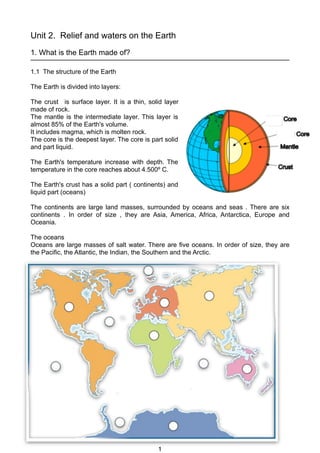
The oceans
Oceans are large masses of salt water. There are five oceans. In order of size, they are
the Pacific, the Atlantic, the Indian, the Southern and the Arctic.
1
2. IES Sáenz de Buruaga Bilingual section
Tectonic plates
The Earth´s crust is divided into different places called tectonic plates. These plates are in
continuous movement. They move slowly at a speed of two to ten centimetres per year.
Some plates move apart , while others collide. The collision of plates has produced many
mountains.
2. WHAT IS THE EARTH´s RELIEF?
The Earth's surface is not flat. There are different kinds of relief.
Continental relief
1. Mountains are high landforms with step sides. The world's highest mountain range
is the Himalaya in Asia.
2. Valleys are areas of low land between mountains.
3. Plains are low, flat areas of land. Large plains are often found on the coast , and are
formed by large rivers.
4. Plateaus are large and high plains. The highest plateau is in Tibet in Asia.
5. Basins are natural depressions, of low areas of land . Some are below sea level.
Coastal relief.
1. A peninsula is an area of land surrounded by water on all sides except one.
2. A cape is a part of the coast which extends into the sea.
3. A gulf is a large area of a sea or ocean partially enclosed by land. A bay is a small
gulf.
4. And island is an area of land surrounded by water on all sides.
5. Archipelago is a group of islands.
Coats can be flat and low-lying or high
• Beaches are in flat coastal areas.
• Cliffs are in high coastal areas.
Oceanic relief.
The ocean floor is irregular.
Its relief is similar to
continental relief.
1. Continental shelves are
near coastlines. These
shelves are vast plateaus
which reach a depth of 150
meters.
2. Continental slopes lead
down to the deeper part of
the oceans.
3. Ocean ridges are large
mountain ranges under the
water. They rise up to 3000
meters from the ocean
floor.
2
3. IES Sáenz de Buruaga Bilingual section
4. Abyssal plains are large and deep underwater plains which reach a depth between 3000
and 5000 meters.
5. Ocean trenches are large, deep depressions in the ocean floor. The deepest ocean
trench is Challenge Deep in the Pacific Ocean
3. WATER
3.1 Water on Earth.
We can distinguish two groups
a. Salt water or sea water is found in oceans and seas
b. Fresh water is found in rivers , lakes, glaciers, groundwaters and at the poles.
3.2 The water cycle.
Water is always moving and changing its physical state. This process is called the water
cycle.
There are several stages in the water cycle
3.3 FRESH WATWER
a. Rivers
Rivers are freshwater body that flows towards the sea, ocean, lake or another river. The
place where river begins is called its source Rivers carry water down to the sea . Smaller
rivers flowing into a larger river are called tributaries.
The area occupied by a river and its tributaries is called a basin
The flow of a river refers to the amount of water it carries.
Parts of a river are:
1. Upper course. The river is quite steep, so water flows with energy and removes
rocks and soil. The river carves canyons or V-shaped valleys. Waterfalls can be
formed there.
3
4. IES Sáenz de Buruaga Bilingual section
2. Middle course . The river is lower down and its slower. It transports the eroded
materials . The landforms are wide shallow valley and meanders.
3. Lower course The river flows very slow so the material is deposited. The main
landforms are wide flat valleys , estuaries and deltas.
b. Lakes are bodies of water surrounded by land. Lakes contain mainly freshwater
however there are some lakes with salt water as Mar Caspio.
c. Groundwaters
Groundwaters run and are stored under the ground. It represents 25% of the water on the
continents. Most groundwaters come from rainfall. Groundwater forms aquifers and
underground rivers and lakes.
d. Glacier
Glaciers are large masses of ice formed by accumulation of snow. Most glaciers are :
1. Polar cap
2. High mountains
Glacier ice is the largest reservoir of freshwater on the Earth
3.4 SALT WATER
It is oceans and seas´ water .
Oceans and seas´water are in permanent movement . There are three types of
movements:
1. Ocean currents are large masses of water. similar to rivers. Currents can be warm or
cold.
2. Tides are the daily rise and fall of the water level caused by attraction of the Moon and
the Sun.Tides can be high tide and low tide.
3. Waves are undulations of the surface of the produced by wind.
Oceans and seas hold almost all the world´s liquid water.
4
5. IES Sáenz de Buruaga Bilingual section
EXERCISES.
1. Define: ocean, continent, mountain.
2. Write the three main layers of the Earth.
3. Write the name of oceans and continents
4. Complete the sentences below:
a. The deepest Earth´s layer _________________________
b. Human life develops in ___________________________
c. Earth´s intermediate layer is _______________________
d. Crust is broken in portions called ___________________
e. A low zone between mountains is a _________________
f. S l o p e t h a t s e p a r a t e s c o n t i n e n t a l s h e l f f r om a b y s s a l p l a i n s
_____________________
g. Underwater mountains are called ___________________
h. Relief is mad by ________________________________
i. Mantle includes ______________ which is molten rock.
5. Answer the next questions:
a. Which is the deepest layer ?
b. Which layer is made of molten rock?
c. Which layer reaches about 4500 Km?
d. How many continents are there?
e. What are the name of the continents?
f. What is the difference between a plateau and a plain?
6. Say if next sentences are true or false?
a. Basins are always under sea level .
b. Abyssal plains are from 200 metres
c. Europe and Asia are part of the same continent land mass.
d. Tectonic plates are Earth´s portions surrounded by water on all sides
e. The largest ocean in the world is the Pacific ocean.
f. Cliffs are in flat coastal areas.
g. Atlantic Ocean is the biggest and deepest ocean.
h. A cape is a part of the coast which extends into the sea
i. A peninsula is an area of land surrounded by water on all sides.
7.Correct the sentence:
a.Most of the Earth’s oceans are in the northern hemisphere,
while most of the land masses are in the southern hemisphere.
b.There are six oceans in the world.
c. Mountains are high landforms with step sides. The world's highest mountain range is the
Himalaya in Asia.
d.Ocean trenches are large, deep depressions in the ocean floor. The deepest ocean
trench is Challenge Deep in the Indian Ocean
5
6. IES Sáenz de Buruaga Bilingual section
8.Write the main phases of the water cycle.
9. Say if next sentences are true or false . Make the right sentence.
a. Rivers begin in a place called course .
b. River is a freshwater body that flows toward the sea or another river.
c. Tributary is a smaller river that flows into a larger river.
10. What are the sentences describing?
a. The river is lower down and its slower. It transports the eroded materials and
foms meanders
b. They are produced by the action of the wind on the surface of the water.
b. The Moon’s gravitational pull produces them.
c. They are large masses of ice formed by accumulation of snow.
c. The time in a day when the level of the sea on the coast is at its lowest
d. They can be warm or cold and move like big rivers across oceans.
11.Choose the correct word to complete each sentence:
a. An ocean is bigger/smaller ___________ than a sea.
b. An ocean ridge is lower/higher __________ than a trench.
c. The upper course of a river flows slower/faster __________ than the
middle course.
d. The Antarctic Ocean is warmer/colder __________ than the Pacific
Ocean.
12.Indicate the course of the river (upper, middle, or lower) depending the characte
ristics.
a. It has a lot of meanders
b. The river is quite steep .
c. The main landforms are wide flat valleys , estuaries and deltas.
c. It is the highest part of the river.
d. Waterfalls can be formed there.
6
7. IES Sáenz de Buruaga Bilingual section
13. Locate the main rivers in the world: Mississippi-Missouri River, Amazon River, Congo
River, Niger River, Nile River, Danube River, Volga River, Lena River, Ob River, Yenisey
River, Yantze River, Huang River
RECURSO 11. RÍOS DEL MUNDO