Downloaded 34 times
![Departamento de Geografía e Historia
ACTIVITIES. WATER IN NATURAL ENVIROMENT.
1. What is the Hydrosphere?
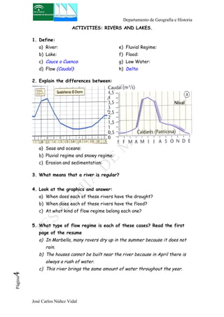
2. Describe the following diagram explaining each step of the water
cycle.
[You can hel yourself with the resume]
3. What is the water cycle?
[Search the meaning on the textbook and the resume but write it in
your own words]
José Carlos Núñez Vidal Página2](https://image.slidesharecdn.com/homeworks-140902061531-phpapp02/85/Homeworks-3-WATER-2-320.jpg)

![Departamento de Geografía e Historia
ACTIVITIES: THE PROBLEM OF WATER.
1. Look at the graphic and answer:
a) What is most abundant on Earth: fresh or salt water? At what rate?
b) Why do we say that water is a problem?
2. What is the drinking water?
3. Look at the graphic below and answer.
[You can find help on the textbook and resume]
a) How has the global consume of water changed?
b) What is water used mostly?
c) Do you think that this use is equal in poor countries and rich
countries? Why?
4. Define:
a) Water treatment plant (Planta Potabilizadora):
b) Reservoir/dam (Embalse o presa):
José Carlos Núñez Vidal Página5](https://image.slidesharecdn.com/homeworks-140902061531-phpapp02/85/Homeworks-3-WATER-5-320.jpg)

![Departamento de Geografía e Historia
ACTIVITIES: RIVERS OF EUROPE.
1. Draw in your notebook a European map and locate on it the
following:
Seas Mar de Barents
José Carlos Núñez Vidal Página7
Mar Báltico
Mar del Norte
Mar Tirreno.
Mar Adriático.
Mar Jónico.
Mar Egeo.
Rivers Loira.
Sena.
Rin
Elba.
Po.
Danubio.
Dniéster.
Dnieper.
Don
Volga.
2. Complete the table comparing the rivers of Europe. [Use the resume]
¿Are they
long or
short?
Why?
Are they
plentiful?
Why?
Are they
regular?
Why?
Which are the
most
important?
Atlantic rivers
Mediterranean
rivers](https://image.slidesharecdn.com/homeworks-140902061531-phpapp02/85/Homeworks-3-WATER-7-320.jpg)
![Departamento de Geografía e Historia
ACTIVITIES: RIVERS OF SPAIN.
1. Draw in your notebook a Spanish map and locate on it the following:
Rivers - Miño.
- Duero.
- Tajo.
- Guadiana.
- Guadalquivir.
- Segura.
José Carlos Núñez Vidal Página8
- Júcar.
- Turia.
- Ebro.
- Ter.
- Llobregat.
Seas
and
oceans
- Cantábrico.
- Atlántico.
- Mediterráneo.
2. Complete the table comparing the rivers of Spain. [Use the resume]
¿Are they
long or
short?
Why?
Are they
plentiful?
Why?
Are they
regular?
Why?
Which are the
most
important?
Atlantic rivers
Mediterranean
rivers
Cantabrico
Rivers](https://image.slidesharecdn.com/homeworks-140902061531-phpapp02/85/Homeworks-3-WATER-8-320.jpg)

This document outlines the key concepts and activities to be covered in a geography exam on water. Students are expected to define key terms related to the hydrosphere, water cycle, oceans, seas, rivers, lakes, and human water usage. They should understand the characteristics and differences between water bodies. Several map activities are included to locate major oceans, seas, rivers and lakes around the world, in Europe, and in Spain. Graphical analysis and comparison of Spanish and European rivers are also listed.


