SlideShare a Scribd company logo
2
What is Remote Sensing?
Remote sensing is a method of obtaining
information about the properties of an object
without coming into physical contact with it.
What is remote sensing used for?
Remote sensing is a method for getting
information about of different objects on the
planet, without any physical contacts with it.
The art, science and technology of obtaining reliable
information about physical objects and the environment,
through the process of recording, measuring and interpreting
imagery and digital representations of energy patterns
derived from noncontact sensor systems.
4
• “Remote sensing is the noncontact recording of
information from the ultraviolet, visible, infrared,
and microwave regions of the electromagnetic
spectrum by means of instruments such as cameras,
scanners, lasers, linear arrays, and/or area arrays
located on platforms such as aircraft or spacecraft,
and the analysis of acquired information by means of
visual and digital image processing.”
5
Three essential Components of Remote Sensing:
1. The Signal (from an object or phenomena)
2. The Sensor (From a platform), and
3. The sensing (Acquiring knowledge about the object or the phenomenon after
analysis of the signals, received by the sensor at the users library )
Remote Sensing Process/Concept
Components
Emission of EMR (Sun/Self emission) (A)
Transmission of energy from the source to
the surface of the earth (absorption and
scattering) (B)
Interaction of EMR with the Earths surface
(reflection & emission) (C)
Transmission of Energy from the surface to
the remote sensor (D)
Sensor data output (E)
Data transmission, processing and Analysis (F)
Application (G)
7
Satellite Remote Sensing of Earth
Electromagnetic Energy
It is the emission of energy from any object having
temperature of absolute zero (00K or -273.150C).
Electromagnetic wave corresponds to oscillations of the
electric and magnetic field vectors perpendicular to each other
and perpendicular to the direction of wave propagation.
If the wave is traveling in the "x" direction (the thumb),
The electric field is oscillating in the "y" direction (index finger), and
The magnetic field is oscillating in the "z" direction (the middle finger).
It is the total range of radiation from short wave to long wave. In
other words, it is the continuous sequence of electromagnetic
energy arranged according to wavelength and frequency.
16
Platforms carry sensors…
• Platforms are airplanes, satellites, balloons, kites,
towers, helicopters etc.
• Passive sensors are like cameras
– Record reflected radiation
– Visible, infrared, ultraviolet, thermal
– Most common: Air photos and most satellites
• Active sensors
– Emit radiation and record the reflectance
– Microwave, Radar, Sonar, Lidar
Cont..
18
Geostationary Orbit
GOES satellites orbit the earth above the equator at the same speed as the earth
rotates so that they can transmit continuous pictures of the region below :
19
Polar Orbit
Polar satellites are sun-synchronous, which means they are able to
observe any place on the Earth and will view every location twice each
day at different illuminations. Polar orbiting take about 100 minutes to
travel from pole to pole and produce high resolution "snapshots” due
to their closeness to the Earth. 20
Orbit Type Characteristics Considerations
Geostationary •Orbits the earth above the
equator at the same speed the
earth rotates
•Orbit is high - ~ 36,000 km
•Can produce animations of the
earth's weather patterns
❑ Good for tracking weather
storms
❑ Can observe changes in time
❑ Can not see the poles very well
❑ Can view only one hemisphere
❑Image resolution is not very good
because of distance from earth
Polar • Orbit around North and South
Poles
•Orbits are lower altitude (~700-
800 km)
•Takes about 100 minutes to travel
from pole to pole
•Produces high resolution “snaps
shots” of the earth
❑ Image resolution is good
because it’s closer to earth
❑ Sees the poles a lot (~14 times
a day)
❑ Sees the given tropical and
middle latitude regions of the globe
twice a day at different illumination.
❑ Used for a variety of
applications, including air quality,
land cover, water quality, and
vegetation studies
Basics of Observation from Satellites
• A digital image comprises of a two
dimensional array of individual picture
elements called pixels arranged in columns
and rows. Each pixel represents an area on
the Earth's surface. Each pixel has an
intensity value (represented by a digital
number) and a location address in the two
dimensional image.
Spectral Signature
• The term spectral signature refers to the relationship
between the wavelength (or frequency) of
electromagnetic radiation and the reflectance of the
surface.
• A spectral signature is some measurable quantity
(e.g., reflectivity, emissivity), which varies as a
function of wavelength and can be used to identify a
material.
• The signature is affected by several things including
the material composition and structure. Some parts of
the EMR spectrum, such as the microwave region, are
more sensitive to surface structure than other regions.
Spectral Reflectance Curves
◼ The % of incident energy
that is reflected from an
object usually varies as a
function of wavelength.
◼ This variation can be
displayed in the form of a
spectral reflectance
curve.
Visible portion of EM
spectrum
Advantages of Remote Sensing
• Provides a view for the large region
• Offers Geo-referenced information and digital
information
• Most of the remote sensors operate in every
season, every day, every time and even in real
tough weather
• Permanent and reliable record
• Cost effective and reliable
• Able to see number of terrain feature in one
scene
• Crop inventory
• Crop Growth monitoring,
• To estimate the crop biomass, LAI etc.,
• Crop acreage estimation
• Crop condition monitoring
• Stress determination in crop
• Crop Yield Forecast.
Applications in Agriculture
➢ Natural Resources mapping such as river, drainage
system, water province etc.,
➢ To draw information on phenology of the crop,
➢ Nutrient management,
➢ Moisture stress,
➢ Pest and Disease detection and extent mapping,
➢ Soil mapping,
➢ Organic matter and nutrient status detection,
➢Precision Farming,
➢Cropping System Analysis,
Cont….
What is GPS?
33
The Global Positioning System (GPS) is a satellite based
navigation system made up of a network of 24 satellites
placed into orbit by U.S. Department of Defense. GPS
works in any weather conditions, any where in the world ,
24 hours a day.
NAVIC own GPS of India
➢India’s own navigational system will be called NAVIC (Navigation with
Indian Constellation) was launched on board the Polar Satellite Launch
Vehicle (PSLV).
➢It is launched at Satish Dhawan Space Centre, Sriharikota, Andhra
Pradesh on April 28, 2016 at 12:50 p.m.
➢ Indian Space Research Organisation (ISRO) have launched 7th satellite
for the purpose of GPS navigation.
➢It will cover 20,657 km from the earth.
GPS
➢ GPS is composed of a constellation of
orbiting satellites which in conjunction
with ground equipment enable users to
determine their exact position anywhere
on the surface of the earth at any time.
34
Global Positioning System
GPS Constellation
24 Satellites in 6 orbital planes
4 satellite in each plane
Orbital period- 11 hr 58 min
Altitude- 20,200 km
Orbital radious-26,600 km
Separation- 60°
Inclination - 55 °
35
NAVSTAR
NAVigation Satellite Timing And Ranging
36
GPS Navigation
37
Components of GPS
The GPS system consists of three segments
1. The Space Segments
Comprising the satellites and transmitted signals
2. The Control Segments
The ground facilities carrying out the task of satellite tracking,
orbit computations and supervision necessary for the daily
control of the space segment.
3. The User Segment
The entire spectrum of applications equipment and
computational techniques that are available to the users.
38
Segments of GPS
39
Uses of GPS
1) To know geo-coordiantes
2) To know altitude
3) To survey
4) For acreage estimation
5) Navigation
6) Transportation
40
41
Data vs. Information
➢Data, by itself, generally differs from information.
➢Data is of little use unless it is transformed into
information.
➢Information is an answer to a question based on raw
data.
➢We transform data into information through the use
of an Information System.
42
43
44
45
Information systems can be very simple,
such as a telephone directory.
46
Geographic Information
System (GIS)
Tool for handling geographic (spatial and descriptive) data. It is an
organized collection of computer hardware, software, geographic
data and the personnel designed to efficiently capture, store,
retrieve, update, manipulate, analyze and display all forms of
geographically referenced information according to the user defined
specifications.
47
Key Components of GIS
Tabular &
Geospatial
data
Hardware
and
Software
Application/
Method
People/
Users
48
49
Sources of geospatial data
Satellite images Attribute data/Statistical tables
Digitized maps Aerial photographs
50
Functions of GIS
51
52
53
54
55
56
57

More Related Content

Similar to RS_GIS_GPS.pdf

35001320006_Saraswati Mahato_Remote sensing and gis_ca 1_2024_even.pdf
35001320006_Saraswati Mahato_Remote sensing and gis_ca 1_2024_even.pdf35001320006_Saraswati Mahato_Remote sensing and gis_ca 1_2024_even.pdf
35001320006_Saraswati Mahato_Remote sensing and gis_ca 1_2024_even.pdf
barunmahato3
 

Similar to RS_GIS_GPS.pdf (20)

remote sensing for study.docx
remote sensing for study.docxremote sensing for study.docx
remote sensing for study.docx
 
35001320006_Saraswati Mahato_Remote sensing and gis_ca 1_2024_even.pdf
35001320006_Saraswati Mahato_Remote sensing and gis_ca 1_2024_even.pdf35001320006_Saraswati Mahato_Remote sensing and gis_ca 1_2024_even.pdf
35001320006_Saraswati Mahato_Remote sensing and gis_ca 1_2024_even.pdf
 
Kannan RS.ppt
Kannan RS.pptKannan RS.ppt
Kannan RS.ppt
 
Satellite science
Satellite scienceSatellite science
Satellite science
 
groundtruth collection for remotesensing support
groundtruth collection for remotesensing supportgroundtruth collection for remotesensing support
groundtruth collection for remotesensing support
 
Remote sensing
Remote sensingRemote sensing
Remote sensing
 
Remote sensing, GPS and GIS ppt
Remote sensing, GPS and GIS pptRemote sensing, GPS and GIS ppt
Remote sensing, GPS and GIS ppt
 
Remote sensing
Remote sensingRemote sensing
Remote sensing
 
Remote sensing and tunneling.pptx
Remote sensing and tunneling.pptxRemote sensing and tunneling.pptx
Remote sensing and tunneling.pptx
 
remote sensing ppt.pptx
remote sensing ppt.pptxremote sensing ppt.pptx
remote sensing ppt.pptx
 
Ch 5 b remote sensing
Ch 5 b remote sensingCh 5 b remote sensing
Ch 5 b remote sensing
 
A STUDY OF INFRA-RED IMAGING SENSORS AND INSTRUMENTS ON GEO-STATIONARY SATELL...
A STUDY OF INFRA-RED IMAGING SENSORS AND INSTRUMENTS ON GEO-STATIONARY SATELL...A STUDY OF INFRA-RED IMAGING SENSORS AND INSTRUMENTS ON GEO-STATIONARY SATELL...
A STUDY OF INFRA-RED IMAGING SENSORS AND INSTRUMENTS ON GEO-STATIONARY SATELL...
 
Scanners, image resolution, orbit in remote sensing, pk mani
Scanners, image resolution, orbit in remote sensing, pk maniScanners, image resolution, orbit in remote sensing, pk mani
Scanners, image resolution, orbit in remote sensing, pk mani
 
Remote sensing in Civil Engineering
Remote sensing in Civil EngineeringRemote sensing in Civil Engineering
Remote sensing in Civil Engineering
 
APPLICATION OF REMOTE SENSING AND GIS IN AGRICULTURE
APPLICATION OF REMOTE SENSING AND GIS IN AGRICULTUREAPPLICATION OF REMOTE SENSING AND GIS IN AGRICULTURE
APPLICATION OF REMOTE SENSING AND GIS IN AGRICULTURE
 
Remote sensing - Sensors, Platforms and Satellite orbits
Remote sensing - Sensors, Platforms and Satellite orbitsRemote sensing - Sensors, Platforms and Satellite orbits
Remote sensing - Sensors, Platforms and Satellite orbits
 
Remote sensing Techniques Dr. Ange Felix NSANZIYERA
Remote sensing Techniques Dr. Ange Felix NSANZIYERARemote sensing Techniques Dr. Ange Felix NSANZIYERA
Remote sensing Techniques Dr. Ange Felix NSANZIYERA
 
Remote sensing
Remote sensingRemote sensing
Remote sensing
 
Report
ReportReport
Report
 
Remote sensing by priyanshu kumar,9608684800
Remote sensing by priyanshu kumar,9608684800Remote sensing by priyanshu kumar,9608684800
Remote sensing by priyanshu kumar,9608684800
 

Recently uploaded

Accounting and finance exit exam 2016 E.C.pdf
Accounting and finance exit exam 2016 E.C.pdfAccounting and finance exit exam 2016 E.C.pdf
Accounting and finance exit exam 2016 E.C.pdf
YibeltalNibretu
 

Recently uploaded (20)

Accounting and finance exit exam 2016 E.C.pdf
Accounting and finance exit exam 2016 E.C.pdfAccounting and finance exit exam 2016 E.C.pdf
Accounting and finance exit exam 2016 E.C.pdf
 
Palestine last event orientationfvgnh .pptx
Palestine last event orientationfvgnh .pptxPalestine last event orientationfvgnh .pptx
Palestine last event orientationfvgnh .pptx
 
B.ed spl. HI pdusu exam paper-2023-24.pdf
B.ed spl. HI pdusu exam paper-2023-24.pdfB.ed spl. HI pdusu exam paper-2023-24.pdf
B.ed spl. HI pdusu exam paper-2023-24.pdf
 
Fish and Chips - have they had their chips
Fish and Chips - have they had their chipsFish and Chips - have they had their chips
Fish and Chips - have they had their chips
 
GIÁO ÁN DẠY THÊM (KẾ HOẠCH BÀI BUỔI 2) - TIẾNG ANH 8 GLOBAL SUCCESS (2 CỘT) N...
GIÁO ÁN DẠY THÊM (KẾ HOẠCH BÀI BUỔI 2) - TIẾNG ANH 8 GLOBAL SUCCESS (2 CỘT) N...GIÁO ÁN DẠY THÊM (KẾ HOẠCH BÀI BUỔI 2) - TIẾNG ANH 8 GLOBAL SUCCESS (2 CỘT) N...
GIÁO ÁN DẠY THÊM (KẾ HOẠCH BÀI BUỔI 2) - TIẾNG ANH 8 GLOBAL SUCCESS (2 CỘT) N...
 
Operations Management - Book1.p - Dr. Abdulfatah A. Salem
Operations Management - Book1.p  - Dr. Abdulfatah A. SalemOperations Management - Book1.p  - Dr. Abdulfatah A. Salem
Operations Management - Book1.p - Dr. Abdulfatah A. Salem
 
Mattingly "AI & Prompt Design: Limitations and Solutions with LLMs"
Mattingly "AI & Prompt Design: Limitations and Solutions with LLMs"Mattingly "AI & Prompt Design: Limitations and Solutions with LLMs"
Mattingly "AI & Prompt Design: Limitations and Solutions with LLMs"
 
Forest and Wildlife Resources Class 10 Free Study Material PDF
Forest and Wildlife Resources Class 10 Free Study Material PDFForest and Wildlife Resources Class 10 Free Study Material PDF
Forest and Wildlife Resources Class 10 Free Study Material PDF
 
Sectors of the Indian Economy - Class 10 Study Notes pdf
Sectors of the Indian Economy - Class 10 Study Notes pdfSectors of the Indian Economy - Class 10 Study Notes pdf
Sectors of the Indian Economy - Class 10 Study Notes pdf
 
aaaaaaaaaaaaaaaaaaaaaaaaaaaaaaaaaaaaaaaaa
aaaaaaaaaaaaaaaaaaaaaaaaaaaaaaaaaaaaaaaaaaaaaaaaaaaaaaaaaaaaaaaaaaaaaaaaaaaaaaaaaa
aaaaaaaaaaaaaaaaaaaaaaaaaaaaaaaaaaaaaaaaa
 
PART A. Introduction to Costumer Service
PART A. Introduction to Costumer ServicePART A. Introduction to Costumer Service
PART A. Introduction to Costumer Service
 
Solid waste management & Types of Basic civil Engineering notes by DJ Sir.pptx
Solid waste management & Types of Basic civil Engineering notes by DJ Sir.pptxSolid waste management & Types of Basic civil Engineering notes by DJ Sir.pptx
Solid waste management & Types of Basic civil Engineering notes by DJ Sir.pptx
 
Basic Civil Engg Notes_Chapter-6_Environment Pollution & Engineering
Basic Civil Engg Notes_Chapter-6_Environment Pollution & EngineeringBasic Civil Engg Notes_Chapter-6_Environment Pollution & Engineering
Basic Civil Engg Notes_Chapter-6_Environment Pollution & Engineering
 
Jose-Rizal-and-Philippine-Nationalism-National-Symbol-2.pptx
Jose-Rizal-and-Philippine-Nationalism-National-Symbol-2.pptxJose-Rizal-and-Philippine-Nationalism-National-Symbol-2.pptx
Jose-Rizal-and-Philippine-Nationalism-National-Symbol-2.pptx
 
50 ĐỀ LUYỆN THI IOE LỚP 9 - NĂM HỌC 2022-2023 (CÓ LINK HÌNH, FILE AUDIO VÀ ĐÁ...
50 ĐỀ LUYỆN THI IOE LỚP 9 - NĂM HỌC 2022-2023 (CÓ LINK HÌNH, FILE AUDIO VÀ ĐÁ...50 ĐỀ LUYỆN THI IOE LỚP 9 - NĂM HỌC 2022-2023 (CÓ LINK HÌNH, FILE AUDIO VÀ ĐÁ...
50 ĐỀ LUYỆN THI IOE LỚP 9 - NĂM HỌC 2022-2023 (CÓ LINK HÌNH, FILE AUDIO VÀ ĐÁ...
 
INU_CAPSTONEDESIGN_비밀번호486_업로드용 발표자료.pdf
INU_CAPSTONEDESIGN_비밀번호486_업로드용 발표자료.pdfINU_CAPSTONEDESIGN_비밀번호486_업로드용 발표자료.pdf
INU_CAPSTONEDESIGN_비밀번호486_업로드용 발표자료.pdf
 
UNIT – IV_PCI Complaints: Complaints and evaluation of complaints, Handling o...
UNIT – IV_PCI Complaints: Complaints and evaluation of complaints, Handling o...UNIT – IV_PCI Complaints: Complaints and evaluation of complaints, Handling o...
UNIT – IV_PCI Complaints: Complaints and evaluation of complaints, Handling o...
 
Ethnobotany and Ethnopharmacology ......
Ethnobotany and Ethnopharmacology ......Ethnobotany and Ethnopharmacology ......
Ethnobotany and Ethnopharmacology ......
 
Gyanartha SciBizTech Quiz slideshare.pptx
Gyanartha SciBizTech Quiz slideshare.pptxGyanartha SciBizTech Quiz slideshare.pptx
Gyanartha SciBizTech Quiz slideshare.pptx
 
The Benefits and Challenges of Open Educational Resources
The Benefits and Challenges of Open Educational ResourcesThe Benefits and Challenges of Open Educational Resources
The Benefits and Challenges of Open Educational Resources
 

RS_GIS_GPS.pdf

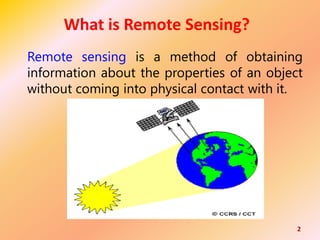
  • 1. 2 What is Remote Sensing? Remote sensing is a method of obtaining information about the properties of an object without coming into physical contact with it.
  • 2. What is remote sensing used for? Remote sensing is a method for getting information about of different objects on the planet, without any physical contacts with it.
  • 3. The art, science and technology of obtaining reliable information about physical objects and the environment, through the process of recording, measuring and interpreting imagery and digital representations of energy patterns derived from noncontact sensor systems. 4
  • 4. • “Remote sensing is the noncontact recording of information from the ultraviolet, visible, infrared, and microwave regions of the electromagnetic spectrum by means of instruments such as cameras, scanners, lasers, linear arrays, and/or area arrays located on platforms such as aircraft or spacecraft, and the analysis of acquired information by means of visual and digital image processing.” 5
  • 5. Three essential Components of Remote Sensing: 1. The Signal (from an object or phenomena) 2. The Sensor (From a platform), and 3. The sensing (Acquiring knowledge about the object or the phenomenon after analysis of the signals, received by the sensor at the users library )
  • 6. Remote Sensing Process/Concept Components Emission of EMR (Sun/Self emission) (A) Transmission of energy from the source to the surface of the earth (absorption and scattering) (B) Interaction of EMR with the Earths surface (reflection & emission) (C) Transmission of Energy from the surface to the remote sensor (D) Sensor data output (E) Data transmission, processing and Analysis (F) Application (G) 7
  • 7.
  • 8.
  • 10. Electromagnetic Energy It is the emission of energy from any object having temperature of absolute zero (00K or -273.150C). Electromagnetic wave corresponds to oscillations of the electric and magnetic field vectors perpendicular to each other and perpendicular to the direction of wave propagation. If the wave is traveling in the "x" direction (the thumb), The electric field is oscillating in the "y" direction (index finger), and The magnetic field is oscillating in the "z" direction (the middle finger).
  • 11. It is the total range of radiation from short wave to long wave. In other words, it is the continuous sequence of electromagnetic energy arranged according to wavelength and frequency.
  • 12.
  • 13.
  • 14.
  • 15. 16
  • 16. Platforms carry sensors… • Platforms are airplanes, satellites, balloons, kites, towers, helicopters etc. • Passive sensors are like cameras – Record reflected radiation – Visible, infrared, ultraviolet, thermal – Most common: Air photos and most satellites • Active sensors – Emit radiation and record the reflectance – Microwave, Radar, Sonar, Lidar
  • 18. Geostationary Orbit GOES satellites orbit the earth above the equator at the same speed as the earth rotates so that they can transmit continuous pictures of the region below : 19
  • 19. Polar Orbit Polar satellites are sun-synchronous, which means they are able to observe any place on the Earth and will view every location twice each day at different illuminations. Polar orbiting take about 100 minutes to travel from pole to pole and produce high resolution "snapshots” due to their closeness to the Earth. 20
  • 20. Orbit Type Characteristics Considerations Geostationary •Orbits the earth above the equator at the same speed the earth rotates •Orbit is high - ~ 36,000 km •Can produce animations of the earth's weather patterns ❑ Good for tracking weather storms ❑ Can observe changes in time ❑ Can not see the poles very well ❑ Can view only one hemisphere ❑Image resolution is not very good because of distance from earth Polar • Orbit around North and South Poles •Orbits are lower altitude (~700- 800 km) •Takes about 100 minutes to travel from pole to pole •Produces high resolution “snaps shots” of the earth ❑ Image resolution is good because it’s closer to earth ❑ Sees the poles a lot (~14 times a day) ❑ Sees the given tropical and middle latitude regions of the globe twice a day at different illumination. ❑ Used for a variety of applications, including air quality, land cover, water quality, and vegetation studies Basics of Observation from Satellites
  • 21. • A digital image comprises of a two dimensional array of individual picture elements called pixels arranged in columns and rows. Each pixel represents an area on the Earth's surface. Each pixel has an intensity value (represented by a digital number) and a location address in the two dimensional image.
  • 22.
  • 23.
  • 24.
  • 25. Spectral Signature • The term spectral signature refers to the relationship between the wavelength (or frequency) of electromagnetic radiation and the reflectance of the surface. • A spectral signature is some measurable quantity (e.g., reflectivity, emissivity), which varies as a function of wavelength and can be used to identify a material. • The signature is affected by several things including the material composition and structure. Some parts of the EMR spectrum, such as the microwave region, are more sensitive to surface structure than other regions.
  • 26.
  • 27. Spectral Reflectance Curves ◼ The % of incident energy that is reflected from an object usually varies as a function of wavelength. ◼ This variation can be displayed in the form of a spectral reflectance curve. Visible portion of EM spectrum
  • 28.
  • 29. Advantages of Remote Sensing • Provides a view for the large region • Offers Geo-referenced information and digital information • Most of the remote sensors operate in every season, every day, every time and even in real tough weather • Permanent and reliable record • Cost effective and reliable • Able to see number of terrain feature in one scene
  • 30. • Crop inventory • Crop Growth monitoring, • To estimate the crop biomass, LAI etc., • Crop acreage estimation • Crop condition monitoring • Stress determination in crop • Crop Yield Forecast. Applications in Agriculture
  • 31. ➢ Natural Resources mapping such as river, drainage system, water province etc., ➢ To draw information on phenology of the crop, ➢ Nutrient management, ➢ Moisture stress, ➢ Pest and Disease detection and extent mapping, ➢ Soil mapping, ➢ Organic matter and nutrient status detection, ➢Precision Farming, ➢Cropping System Analysis, Cont….
  • 32. What is GPS? 33 The Global Positioning System (GPS) is a satellite based navigation system made up of a network of 24 satellites placed into orbit by U.S. Department of Defense. GPS works in any weather conditions, any where in the world , 24 hours a day. NAVIC own GPS of India ➢India’s own navigational system will be called NAVIC (Navigation with Indian Constellation) was launched on board the Polar Satellite Launch Vehicle (PSLV). ➢It is launched at Satish Dhawan Space Centre, Sriharikota, Andhra Pradesh on April 28, 2016 at 12:50 p.m. ➢ Indian Space Research Organisation (ISRO) have launched 7th satellite for the purpose of GPS navigation. ➢It will cover 20,657 km from the earth.
  • 33. GPS ➢ GPS is composed of a constellation of orbiting satellites which in conjunction with ground equipment enable users to determine their exact position anywhere on the surface of the earth at any time. 34 Global Positioning System
  • 34. GPS Constellation 24 Satellites in 6 orbital planes 4 satellite in each plane Orbital period- 11 hr 58 min Altitude- 20,200 km Orbital radious-26,600 km Separation- 60° Inclination - 55 ° 35 NAVSTAR NAVigation Satellite Timing And Ranging
  • 37. The GPS system consists of three segments 1. The Space Segments Comprising the satellites and transmitted signals 2. The Control Segments The ground facilities carrying out the task of satellite tracking, orbit computations and supervision necessary for the daily control of the space segment. 3. The User Segment The entire spectrum of applications equipment and computational techniques that are available to the users. 38 Segments of GPS
  • 38. 39 Uses of GPS 1) To know geo-coordiantes 2) To know altitude 3) To survey 4) For acreage estimation 5) Navigation 6) Transportation
  • 39. 40
  • 40. 41 Data vs. Information ➢Data, by itself, generally differs from information. ➢Data is of little use unless it is transformed into information. ➢Information is an answer to a question based on raw data. ➢We transform data into information through the use of an Information System.
  • 41. 42
  • 42. 43
  • 43. 44
  • 44. 45 Information systems can be very simple, such as a telephone directory.
  • 45. 46
  • 46. Geographic Information System (GIS) Tool for handling geographic (spatial and descriptive) data. It is an organized collection of computer hardware, software, geographic data and the personnel designed to efficiently capture, store, retrieve, update, manipulate, analyze and display all forms of geographically referenced information according to the user defined specifications. 47
  • 47. Key Components of GIS Tabular & Geospatial data Hardware and Software Application/ Method People/ Users 48
  • 48. 49 Sources of geospatial data Satellite images Attribute data/Statistical tables Digitized maps Aerial photographs
  • 49. 50
  • 51. 52
  • 52. 53
  • 53. 54
  • 54. 55
  • 55. 56
  • 56. 57