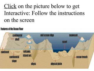
Oceanography
• Ocean: >3 million sq km
– Pacific, Atlantic, Indian, Arctic
– all are actually connected

• Sea:<3 million sq km, partly
enclosed by land
Measuring Ocean Depth:
• First done with knotted ropes
• later, sonar (SOund NAvigation
Ranging) used sound waves
• most ocean mapping now done
with satellites
Sonar
Sonar
Sound
Density
Image
Marine Geology
• Many seafloor features are
caused by plate tectonics; others
by erosion and deposition
• 2 sections of seafloor
– 1. ocean basin: deep; oceanic
crust
• 2. continental margins:

shallow; cont. crust covered
by water
–active margins: have a trench
or MOR
–passive margins: none
Passive Margin
Passive Margin
Passive Margin (Atlantic-Type Margin)
• continental margin moving away from the
mid-ocean spreading center;
• these margins have no mountain building
activities;
• get thick sediment deposits here that cover
up the oceanic crust and the boundary
between oceanic and continental crust
Passive Margin (Atlantic-Type Margin)
Active Margin (Pacific-Type Margin)
•
•
•
•
•

•

continental margin is moving toward a subduction zone; is marked by active
volcanoes, many earthquakes, and young mountains and elevation of land
(because overlying plate is pushed up by subducting plate)
oceanic crust and overlying sediment are partially melted at an active margin as
plate is pulled downward;
continents can grow here as ocean-bottom structures melt and weld onto the
continental plate and as volcanoes erupt and spew lava
area of intense earthquakes because friction builds up when upper plate scraps
across subducting plate (like a up-down transform fault); strain on the rocks
build up and eventually the rocks fail (get a fault zone)
where subducting plate is old, cold and dense, it sinks into the mantle as a
steeply dipping slab (occurs in western Pacific) -- can get volcanic activity here
that will create new, small spreading centers (back-arc spreading centers);
continental plate will retreat from these small spreading centers (low stress
convergence)
where subducting plate is young, warm and buoyant, slab dips at a gentle angle,
resulting in volcanic activity that erupts on land; continental plate will advance
here (high stress convergence)
Active Margin
Active Margin
Active Margin
Continental Margins
• 1.Continental shelf: shallow; flat;
continental crust covered by H20.
–active margin: shelf is narrow;
bordered by ocean trench and
coastal mountains
–passive margin: wide, flat shelf;
no trench, flat coastal land
Active Margins
These are Profiles of the Ocean Floor
Passive Margins
These are Profiles of the Ocean Floor
• 2. Continental slope: steep
boundary between oceanic
(thin) and continental (thick)
crust
– active margin: slope ends at
trench
• 3. Continental rise: gently
sloping, thick pile of sediments
at base of continental slope
– passive margins only
• Submarine Canyon: deep cut
at right angle to shelf
– may be a drowned river valley
– may be formed by fast-moving
currents that create landslides
that erode the canyon
Submarine
Canyon
B. Ocean Basin
• 5. Abyssal plains: flat, thick
layers of sediments.
• 6. Abyssal hills: small hills;
probably parts of crust not yet
covered by sediments.
• 7. Seamounts: underwater
volcanoes
8. Guyot: seamount w/flat top
that was eroded by waves
9. Mid-ocean ridge(MOR): undersea
chain of volcanic mountains; where
new crust is formed.
• MOR’s have active hydrothermal
vents or “black smokers” where
mineral-rich, superheated water
comes out
• site of chemosynthetic ecosystems
where life is not based on sunlight
but on the chemicals in the water
Black Smoker

Tube worms
Birth of Deep Sea Vents
(click on picture)
• Trench: long, narrow, deep;
parallel to coast
–converging boundary
–ocean crust destroyed
–deepest is Marianas Trench,
11km below sea level
Trench
Side View of Ocean Floor Features
Click on the picture below to get
Interactive: Follow the instructions
on the screen
References
• http://www.classzone.com/books/earth_science/terc/con
tent/investigations/es2301/es2301page05.cfm

Seafloor Features

  • 1.
  • 2.
    • Ocean: >3million sq km – Pacific, Atlantic, Indian, Arctic – all are actually connected • Sea:<3 million sq km, partly enclosed by land
  • 3.
    Measuring Ocean Depth: •First done with knotted ropes • later, sonar (SOund NAvigation Ranging) used sound waves • most ocean mapping now done with satellites
  • 4.
  • 5.
  • 6.
    Marine Geology • Manyseafloor features are caused by plate tectonics; others by erosion and deposition • 2 sections of seafloor – 1. ocean basin: deep; oceanic crust
  • 7.
    • 2. continentalmargins: shallow; cont. crust covered by water –active margins: have a trench or MOR –passive margins: none
  • 8.
  • 9.
  • 10.
    Passive Margin (Atlantic-TypeMargin) • continental margin moving away from the mid-ocean spreading center; • these margins have no mountain building activities; • get thick sediment deposits here that cover up the oceanic crust and the boundary between oceanic and continental crust
  • 11.
  • 12.
    Active Margin (Pacific-TypeMargin) • • • • • • continental margin is moving toward a subduction zone; is marked by active volcanoes, many earthquakes, and young mountains and elevation of land (because overlying plate is pushed up by subducting plate) oceanic crust and overlying sediment are partially melted at an active margin as plate is pulled downward; continents can grow here as ocean-bottom structures melt and weld onto the continental plate and as volcanoes erupt and spew lava area of intense earthquakes because friction builds up when upper plate scraps across subducting plate (like a up-down transform fault); strain on the rocks build up and eventually the rocks fail (get a fault zone) where subducting plate is old, cold and dense, it sinks into the mantle as a steeply dipping slab (occurs in western Pacific) -- can get volcanic activity here that will create new, small spreading centers (back-arc spreading centers); continental plate will retreat from these small spreading centers (low stress convergence) where subducting plate is young, warm and buoyant, slab dips at a gentle angle, resulting in volcanic activity that erupts on land; continental plate will advance here (high stress convergence)
  • 13.
  • 14.
  • 15.
  • 16.
    Continental Margins • 1.Continentalshelf: shallow; flat; continental crust covered by H20. –active margin: shelf is narrow; bordered by ocean trench and coastal mountains –passive margin: wide, flat shelf; no trench, flat coastal land
  • 17.
    Active Margins These areProfiles of the Ocean Floor
  • 18.
    Passive Margins These areProfiles of the Ocean Floor
  • 19.
    • 2. Continentalslope: steep boundary between oceanic (thin) and continental (thick) crust – active margin: slope ends at trench
  • 20.
    • 3. Continentalrise: gently sloping, thick pile of sediments at base of continental slope – passive margins only
  • 21.
    • Submarine Canyon:deep cut at right angle to shelf – may be a drowned river valley – may be formed by fast-moving currents that create landslides that erode the canyon
  • 22.
  • 23.
    B. Ocean Basin •5. Abyssal plains: flat, thick layers of sediments. • 6. Abyssal hills: small hills; probably parts of crust not yet covered by sediments.
  • 25.
    • 7. Seamounts:underwater volcanoes
  • 26.
    8. Guyot: seamountw/flat top that was eroded by waves
  • 27.
    9. Mid-ocean ridge(MOR):undersea chain of volcanic mountains; where new crust is formed.
  • 28.
    • MOR’s haveactive hydrothermal vents or “black smokers” where mineral-rich, superheated water comes out • site of chemosynthetic ecosystems where life is not based on sunlight but on the chemicals in the water
  • 29.
  • 30.
    Birth of DeepSea Vents (click on picture)
  • 31.
    • Trench: long,narrow, deep; parallel to coast –converging boundary –ocean crust destroyed –deepest is Marianas Trench, 11km below sea level
  • 32.
  • 34.
    Side View ofOcean Floor Features
  • 35.
    Click on thepicture below to get Interactive: Follow the instructions on the screen
  • 36.