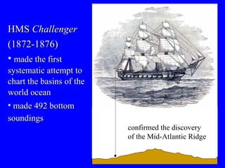
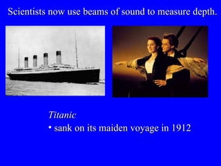
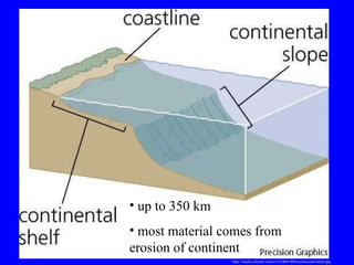
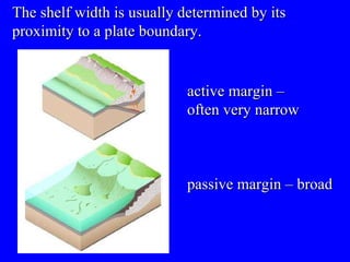
Lecture #6 Continental Margins and Ocean Basins  22 August 2007
The ocean floor is mapped by bathymetry http://www.the-planet-mars.com/spacecraft/Mars-global-surveyor.html Mars Global Surveyor   Mars
http://www.the-planet-mars.com/map-of-mars.html
n o oceans few storms  Mars http://www.modern.tsukuba.ac.jp/earth.jpg Earth oceans and clouds cover 75% of the surface
Posidonius  conducted the first bathymetric studies 85 B.C. http://www-groups.mcs.st-and.ac.uk/history/BigPictures/Posidonius.jpeg 2 km Bathymetry  = study of ocean floor contours The early, simplest methods involved lowering a weight on a line.
http://www.nefsc.noaa.gov/history/ships/albatross1/sigsbee-sounding.jpg Sigbee sounding machine developed around 18 80 Tanner sounding machine  developed around 18 80 http://woodshole.er.usgs.gov/operations/sfmapping/images/theb0914_small.jpg Sometimes the weight was tipped with wax to retrieve a sample of bottom sediment.
HMS  Challenger (1872-1876) made the first systematic attempt to chart the basins of the world ocean made 492 bottom soundings   confirmed the discovery of the Mid-Atlantic Ridge
Scientists now use beams of sound to measure depth.
Scientists now use beams of sound to measure depth.  Titanic sank on its maiden voyage in 1912
http://en.wikipedia.org/wiki/Reginald_Fessenden Reginald Fessenden (1866-1932) Canadian inventor in 1914, developed a type of sonar system for locating icebergs “ Iceberg Detector and Echo Depth Sounder”
V = speed of sound in water (about 1.5 km/sec) T = time Echo sounders sense the contour of the seafloor by beaming sound waves to the bottom and measuring the time required for the sound waves to bounce back to the ship.
During World War I (1914-1918) used to detect enemy  submarines http://www.eastlanddisaster.org/uc97.jpg Meteor  expedition (1925-1927) used to study the seabed   http://oceanworld.tamu.edu/resources/ocng_textbook/chapter02/Images/Fig2-2s.jpg
World Ocean Floor
http://www.panorama-map.com/Europeans/Berann/berannpacificocean500.html Pacific Ocean
http://www.berann.com/panorama/Everest.jpg Mt. Everest  (1962)
Two new techniques improved studies of the seafloor: 1) multibeam echo sounders  2) satellite altimetry
Multibeam systems combine many echo sounders. up to 121 beams signal sent every 10 secs <200 research vessels are equipped with multibeam systems
  Seabed contours can be mapped using  satellites . Satellites cannot measure ocean depths directly but, they can measure  sea surface height
Sea surface   Seafloor
? Sea surface   Seafloor
Gravitational attraction “pulls” water Over a 2000 m seamount, water rises about 2 m Seafloor   Sea surface
Geosat satellite
http://www.ngdc.noaa.gov/mgg/image/global_grav_large.gif Mapped by:  Geosat ,  TOPEX/Poseidon , and  Jason-1 Seafloor topography inferred from sea surface height measurements
Ocean-floor topography varies with location
>50% of Earth’s surface is >3,000 m below sea level
Oceans can be divided into two major provinces:  1)  continental margin 2)  ocean basin
earthquakes volcanic activity Continental margins are “ active ” or “ passive ”. no earthquakes no volcanic activity Face the edges of diverging plates   Near converging plates
Three main parts of the continental margin:
Continental shelf:  shallow submerged extension of a continent
http://media.allrefer.com/s1/l/c0601400-continental-shelf.jpg up to 350 km most material comes from erosion of continent
http://www.cryingvoice.com/Evolution/gifs/hydroNA.jpg Atlantic
active margin – often very narrow passive margin – broad The shelf width is usually determined by its proximity to a plate boundary.
Continental shelves are greatly influenced by changes in sea level Sea level rise
http://en.wikipedia.org/wiki/Image:Sea_level_temp_140ky.gif Sea level is now high and rising as the ocean warms.   Wisconsin glaciation
ice age http://en.wikipedia.org/wiki/Image:Northern_icesheet_hg.png Wisconsin glaciation 70,000 to 10,000 years ago Ice sheets 3-4 m thick caused sea level to drop 125 m
http://whyfiles.org/shorties/202mass_extinct/images/land_bridge.gif Bering Strait
http://whyfiles.org/shorties/202mass_extinct/images/land_bridge.gif Allowed human migration 12,000 years ago Bering Strait
http://www.morien-institute.org/images/korea_2_sing.jpg Ice age sea level in Asia
http://cocos.arecaceae.com/indo19.gif Ice age sea level in Asia
Continental slopes connect continental shelves to the deep-ocean floor shelf break
Submarine canyons form at the junction between continental shelf and continental slope.
http://www.tahoemaps.com/files/Monterey_large.jpg Monterey Bay canyon
http://www.marine-geo.org/gallery/images/MontereyBay3D.jpg 2000 m Monterey Bay canyon
Suruga Bay
How do submarine canyons form?   Submarine canyons cut into the continental shelf and slope, often terminating on the deep-sea floor in a fan-shaped wedge of sediment.
Submarine cables near Nova Scotia, Canada http://www.geol.lsu.edu/Faculty/Juan/PhysicalGeology_F2004/images/Turbidity2.gif
 
turbidity current an underwater “avalanche” of sediment http://unit.aist.go.jp/igg/rg/igi-rg/beta/sl-support/R-formation/TurbidityCurrent.jpg Most geologists believe that submarine canyons have been formed by abrasive turbidity currents plunging down the canyons.
Continental rises form as sediments accumulate at the base of the continental slope   continental rise much sediment most of the sediment that forms the continental rise is transported to the area by turbidity currents
The topology of deep-ocean basins differs from that of the continental margin Deep-ocean basins comprise mainly: oceanic ridge systems sediment-covered plains
Oceanic ridges circle the world underwater mountain ranges stretch 65,000 km often covered with little sediment
http://www.berann.com/panorama/archive/image/PN_W_10.jpg Mid-Atlantic Ridge
Iceland fracture 15 cm/year http://library.thinkquest.org/C003124/images/diverg.jpg
http://www.berann.com/panorama/archive/image/PN_W_10.jpg Mid-Atlantic Ridge
http://www.berann.com/panorama/archive/image/PN_W_10.jpg Mid-Atlantic Ridge transform faults fracture zones
Hydrothermal vents are hot springs on active oceanic ridges discovered in 1977 by Robert Ballard and J. F. Grassle Alvin http://www.mbari.org/molecular/images/EPR%20mussel-map.jpg
Alvin can carry 3 people can dive to 4000 m 1964 – 2007 >4000 dives manned submersible 6,500 m unmanned submersible 11,000 m
http://www.csa.com/discoveryguides/vent/images/smoker.jpg http://whyfiles.org/coolimages/images/csi/nur04506.jpg “ black smokers”   20 m 350 o C 2,800 m depth solutions exiting vents are acidic (pH = ~3.5) and contain up to 300 ppm  hydrogen sulfide (H 2 S)  a highly reduced molecule, so much energy can be obtained when it is oxidized
http://www.divediscover.whoi.edu/images/vent_chemistry.jpg “ black smokers” seawater is heated and reacts chemically with the surrounding basalt
hydrothermal vent community http://www.sciencedaily.com/images/2005/02/050223124700.jpg includes snails, shrimps, crabs,  tube worms , fishes and octopuses  depends on chemosynthetic bacteria for food chemosynthesis  Tube worms   deep-sea vent mussels
Hydrothermal vents are common on oceanic ridges http://www.nature.com/nature/journal/v439/n7079/images/hydro_vents/index.html AND in freshwater (Lake Baikal)
Abyssal plains and abyssal hills cover most of Earth’s surface. Abyssal hills small sediment-covered extinct volcanos or rock Abyssal plains 40% of the ocean floor common in the Atlantic rare in the Pacific covered by sediment Flat
  Volcanic seamounts and guyots project above the seabed about 30,000 about 10,000 in the Pacific http://upload.wikimedia.org/wikipedia/en/thumb/2/25/Seamount_Locations.png/350px-Seamount_Locations.png >1 km in height important fishing areas Emperor Seamounts seamount
blobfish   orange roughy southern spineback southern whiptail
Guyot :  f lat-topped seamount that once reached the surface http://en.wikipedia.org/wiki/Image:Guyot.jpg
Trench :  arc-shaped depression on the deep-ocean floor occur near subduction zones deepest places in the ocean most in the Pacific http://geology.com/records/ocean-trench.gif
Peru-Chile trench http://en.wikipedia.org/wiki/Image:Peru-Chile_trench.jpg Puerto Rico trench
Japan Trench 10,595 m Mariana Trench 11,022 m
Trieste reached the bottom  of the Mariana Trench  in 1960
Kaiko  Japanese deep-sea submarine sampled bacteria from the bottom (10,897 m) of the Mariana Trench in 1996
Sampling of the world's deepest sea sediment by &quot; Kaiko &quot; at the Mariana Trench, Challenger Deep Bacteria collected from the Mariana Trench
lost at sea in typhoon in 2003
Key Points 1. The ocean floor is mapped by bathymetry . 2. Ocean-floor topography varies with location . 3. Continental margins are “active” or “passive”. 4. The topology of deep-ocean basins differs from that of the continental margin.

Lecture6