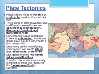
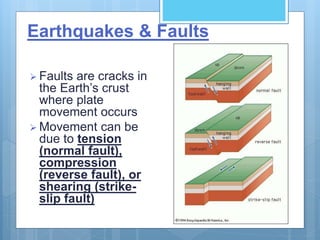
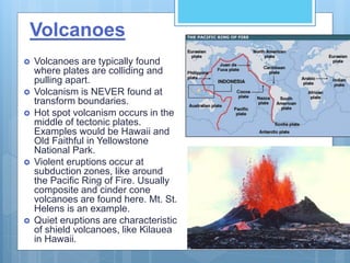
Plate Tectonics,
Earthquakes, &
Volcanoes
Structure of the Earth
 Lithosphere: crust and
upper part of mantle
 Asthenosphere: plastic-
like part of mantle where
convection currents are
found
 Mesosphere: lower part
of mantle
 Outer core: liquid iron
and nickel
 Inner core: solid iron and
nickel
Plate Tectonics
 Plates can be made of oceanic or
continental crust, and sometimes
both
 Three types of plate movement due
to different stresses/forces are
convergence (compression),
divergence (tension), and
transform (shear)
 Convergence is also sometimes
known as subduction, where one
dense plate is pulled underneath a
less dense plate
 Depending on the type of plate,
convergence can create island
arcs, mountains, or trenches
 Divergence creates mid-ocean
ridges and rift valleys
 Transform boundaries are usually
identified by strike-slip faults, like
the San Andreas Fault in
California
Plate Movement
Earthquakes & Faults
 Faults are cracks in
the Earth’s crust
where plate
movement occurs
 Movement can be
due to tension
(normal fault),
compression
(reverse fault), or
shearing (strike-
slip fault)
Where Do Earthquakes Happen?
Wherever there is
stress that builds up in
the Earth, it gets
released at the focus
The energy that is
released is done so
through primary
(compressional),
secondary
(shearing), and
surface waves
Volcanoes
 Volcanoes are typically found
where plates are colliding and
pulling apart.
 Volcanism is NEVER found at
transform boundaries.
 Hot spot volcanism occurs in the
middle of tectonic plates.
Examples would be Hawaii and
Old Faithful in Yellowstone
National Park.
 Violent eruptions occur at
subduction zones, like around
the Pacific Ring of Fire. Usually
composite and cinder cone
volcanoes are found here. Mt. St.
Helens is an example.
 Quiet eruptions are characteristic
of shield volcanoes, like Kilauea
in Hawaii.
Geologic Provinces of VA
 A physiographic
province is a landform
region, an area
delineated according to
similar terrain that has
been shaped by a
common geologic
history.
 Each province is
characterized overall by
its elevation, relief,
lithology, and
geologic structure.
Geologic Provinces, cont’d
 Appalachian Plateau: Although some parts of the plateau are relatively flat,
there are many valleys and stream hollows, making it much of the Appalachian
Plateau very hilly and rugged. The upper Paleozoic layers of the plateau are rich
in mineral resources like coal, natural gas, and petroleum.
 Valley and Ridge: made up of long parallel ridges and valleys with folded
Paleozoic sedimentary rock below and inside them. Cambrian-aged sandstones
(540 million years-old) from the western Blue Ridge are overlain by carbonates
that made up a big region of limestone and dolomite called the Great American
Carbonate Bank. Today these carbonates (up to 3.5 kilometers in thickness) are
exposed in the Great Valley, the easternmost portion of the Valley & Ridge
province. Well-developed caves and sinkholes can be found in the Great Valley.
 Blue Ridge: In Virginia, the oldest rocks in the Blue Ridge province are different
types of granite which date back 1,200,000,000 years. The rocks that make up
the Blue Ridge have been shoved over the rock layers of the Valley & Ridge
province. The rocks were moved to the northwest when Africa and North America
got sandwiched together, pushing the Blue Ridge on top of the Valley & Ridge
along a fault line. By being deformed, older igneous and metamorphic rocks show
that the continents crunched together and split apart many times during the
Paleozoic.
 Piedmont: is the largest physiographic province in Virginia. It is bounded on the
east by the Fall Zone, which separates the province from the Coastal Plain, and
on the west by the mountains of the Blue Ridge province. A variety of igneous
and metamorphic rocks make up the bedrock of the Piedmont province.
 Coastal Plain: extends from the Fall Zone eastward to the Atlantic Ocean.
Through the Fall Zone, the larger streams cascade off the resistant igneous and
metamorphic rocks of the Piedmont to sea level. The topography of the Coastal
Plain is a terraced landscape that stair-steps down to the coast and to the major
rivers.

Plate Tectonics

  • 1.
  • 2.
    Structure of theEarth  Lithosphere: crust and upper part of mantle  Asthenosphere: plastic- like part of mantle where convection currents are found  Mesosphere: lower part of mantle  Outer core: liquid iron and nickel  Inner core: solid iron and nickel
  • 3.
    Plate Tectonics  Platescan be made of oceanic or continental crust, and sometimes both  Three types of plate movement due to different stresses/forces are convergence (compression), divergence (tension), and transform (shear)  Convergence is also sometimes known as subduction, where one dense plate is pulled underneath a less dense plate  Depending on the type of plate, convergence can create island arcs, mountains, or trenches  Divergence creates mid-ocean ridges and rift valleys  Transform boundaries are usually identified by strike-slip faults, like the San Andreas Fault in California
  • 4.
  • 5.
    Earthquakes & Faults Faults are cracks in the Earth’s crust where plate movement occurs  Movement can be due to tension (normal fault), compression (reverse fault), or shearing (strike- slip fault)
  • 6.
    Where Do EarthquakesHappen? Wherever there is stress that builds up in the Earth, it gets released at the focus The energy that is released is done so through primary (compressional), secondary (shearing), and surface waves
  • 7.
    Volcanoes  Volcanoes aretypically found where plates are colliding and pulling apart.  Volcanism is NEVER found at transform boundaries.  Hot spot volcanism occurs in the middle of tectonic plates. Examples would be Hawaii and Old Faithful in Yellowstone National Park.  Violent eruptions occur at subduction zones, like around the Pacific Ring of Fire. Usually composite and cinder cone volcanoes are found here. Mt. St. Helens is an example.  Quiet eruptions are characteristic of shield volcanoes, like Kilauea in Hawaii.
  • 8.
    Geologic Provinces ofVA  A physiographic province is a landform region, an area delineated according to similar terrain that has been shaped by a common geologic history.  Each province is characterized overall by its elevation, relief, lithology, and geologic structure.
  • 9.
    Geologic Provinces, cont’d Appalachian Plateau: Although some parts of the plateau are relatively flat, there are many valleys and stream hollows, making it much of the Appalachian Plateau very hilly and rugged. The upper Paleozoic layers of the plateau are rich in mineral resources like coal, natural gas, and petroleum.  Valley and Ridge: made up of long parallel ridges and valleys with folded Paleozoic sedimentary rock below and inside them. Cambrian-aged sandstones (540 million years-old) from the western Blue Ridge are overlain by carbonates that made up a big region of limestone and dolomite called the Great American Carbonate Bank. Today these carbonates (up to 3.5 kilometers in thickness) are exposed in the Great Valley, the easternmost portion of the Valley & Ridge province. Well-developed caves and sinkholes can be found in the Great Valley.  Blue Ridge: In Virginia, the oldest rocks in the Blue Ridge province are different types of granite which date back 1,200,000,000 years. The rocks that make up the Blue Ridge have been shoved over the rock layers of the Valley & Ridge province. The rocks were moved to the northwest when Africa and North America got sandwiched together, pushing the Blue Ridge on top of the Valley & Ridge along a fault line. By being deformed, older igneous and metamorphic rocks show that the continents crunched together and split apart many times during the Paleozoic.  Piedmont: is the largest physiographic province in Virginia. It is bounded on the east by the Fall Zone, which separates the province from the Coastal Plain, and on the west by the mountains of the Blue Ridge province. A variety of igneous and metamorphic rocks make up the bedrock of the Piedmont province.  Coastal Plain: extends from the Fall Zone eastward to the Atlantic Ocean. Through the Fall Zone, the larger streams cascade off the resistant igneous and metamorphic rocks of the Piedmont to sea level. The topography of the Coastal Plain is a terraced landscape that stair-steps down to the coast and to the major rivers.