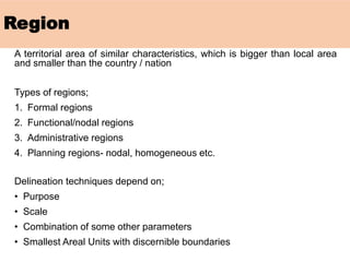
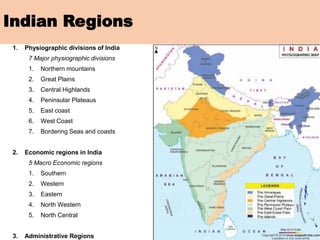
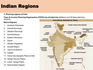
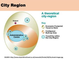
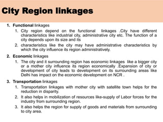
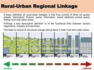
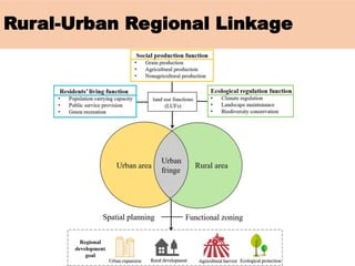
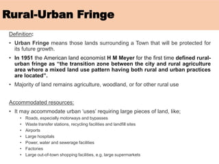
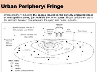
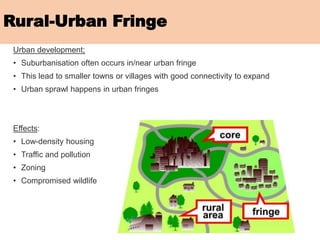
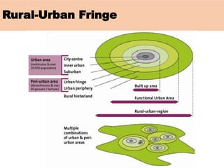
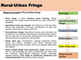
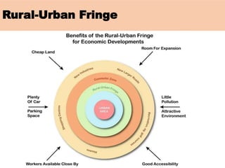
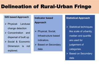
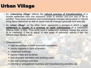
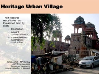
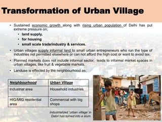
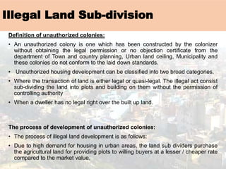
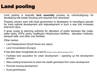
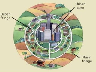
REGION!
Region
A territorial area of similar characteristics, which is bigger than local area
and smaller than the country / nation
Types of regions;
1. Formal regions
2. Functional/nodal regions
3. Administrative regions
4. Planning regions- nodal, homogeneous etc.
Delineation techniques depend on;
• Purpose
• Scale
• Combination of some other parameters
• Smallest Areal Units with discernible boundaries
Indian Regions
1. Physiographic divisions of India
7 Major physiographic divisions
1. Northern mountains
2. Great Plains
3. Central Highlands
4. Peninsular Plateaus
5. East coast
6. West Coast
7. Bordering Seas and coasts
2. Economic regions in India
5 Macro Economic regions
1. Southern
2. Western
3. Eastern
4. North Western
5. North Central
3. Administrative Regions
Indian Regions
4. Planning regions of India
Town & Country Planning Organisation (TCPO) has divided into 14 Macro and 35 Meso planning
divisons.
Macro Regions
1. Southern Peninsular
2. Central Peninsula
3. Western Peninsula
4. Central Deccan
5. Eastern Peninsula
6. Gujrat
7. Western Rajasthan
8. Aravalli Region
9. Jammu & Kashmir
10. Ladakh
11. Trans Indo Gangetic Plains & Hills
12. Ganga Yamuna Plains
13. Lower Ganga Plains
14. North Eastern Region
City Region
SOURCE: http://www.airportdirecttravel.co.uk/newcastle/Portals/18/City-break-images.jpg
City Region linkages
1. Functional linkages
1. City region depend on the functional linkages .City have different
characteristics like industrial city, administrative city etc. The function of a
city depends upon its size and its
2. characteristics like the city may have administrative characteristics by
which the city influence its region administratively.
2. Economic linkages
1. The city and it surrounding region has economic linkages like a bigger city
or a mother city influence its region economically .Expansion of city or
development of city leads to development on its surrounding areas like
Delhi has impact on the economic development on NCR .
3. Transportation linkages
1. Transportation linkages with mother city with satellite town helps for the
reduction in disparity.
2. It also helps in mobilization of resources like-supply of Labor forces for the
industry from surrounding region.
3. It also helps the region for supply of goods and materials from surrounding
to city area.
RURAL-URBAN REGIONAL LINKAGES
Rural-Urban Regional Linkage
A basic definition of rural-urban linkages is that they consist of flows (of goods,
people, information, finance, waste, information, social relations) across space,
linking rural and urban areas.
Perhaps a less descriptive definition is of the functional links between sectors
(agriculture, industry and services).
The latter is central to structural change taking place in both rural and urban areas.
Rural-Urban Regional Linkage
URBAN FRINGE
Rural-Urban Fringe
Definition:
• Urban Fringe means those lands surrounding a Town that will be protected for
its future growth.
• In 1951 the American land economist H M Meyer for the first time defined rural-
urban fringe as “the transition zone between the city and rural agriculture
area where a mixed land use pattern having both rural and urban practices
are located”.
• Majority of land remains agriculture, woodland, or for other rural use
Accommodated resources:
• It may accommodate urban ‘uses’ requiring large pieces of land, like;
• Roads, especially motorways and bypasses
• Waste transfer stations, recycling facilities and landfill sites
• Airports
• Large hospitals
• Power, water and sewerage facilities
• Factories
• Large out-of-town shopping facilities, e.g. large supermarkets
Urban Periphery/ Fringe
Urban periphery indicates the spaces located in the densely urbanized zones
of metropolitan areas, just outside the inner zones. Urban peripheries are at
the interface between core cities and the outer, less dense, suburbs.
Rural-Urban Fringe
Urban development;
• Suburbanisation often occurs in/near urban fringe
• This lead to smaller towns or villages with good connectivity to expand
• Urban sprawl happens in urban fringes
Effects:
• Low-density housing
• Traffic and pollution
• Zoning
• Compromised wildlife
Rural-Urban Fringe
Identification:
The Census of India has observed the following criteria:
• Population density shall be less than 400 persons/km square
• The decadal population growth rate should be 40% or more.
• Sex ratio should be greater than 800 females per 1000 males (due to
outmigration for work)
• Outer limit of the city should have bus service or the local train service.
• 50% or more male workers are involved in non agriculture
occupations.
Land use characteristic:
• There is constantly changing pattern of land use.
• Residential expansion is rapid.
• Farms are small with intensive crop production.
• Service and other public facilities are inadequate.
• Science and business parks development.
• Airport expansion.
• Speculative building is common.
Rural-Urban Fringe
Social characteristic:
• Segregation: Rural urban fringe also known
as “Greenfield site“ (undeveloped sites
outside the existing built up urban area) which
are favoured by large firms seeking locations
for new developments such as headquarters,
offices, housing and industrial estates. So
there is functional and social segregation
of land use.
• Selective Immigration: The rural urban fringe
attracts middle class residents who form a
small but powerful and economically important
proportion of the city population. Service and
other public facilities are inadequate in fringe
region which lead to immigration.
• Commuting: People living in fringe
area commute daily to their place of work.
This creates the dual problem of traffic
congestion in the city, the city govt is faced
with the task of providing transport service
handling peak load.
Rural-Urban Fringe
Types of Rural Urban Fringe
The rural-urban fringe is a dynamic zone. It changes its shape and limits with
an increase in urban facilities. The fringe area can be placed in two groups.
1. Primary urban fringe – This belt touches the outer administrative limit of
the city. After development, it witnesses rapid development of urban facilities
and various activities.
2. Secondary urban fringe – Secondary urban fringe is an area extending
outside the primary urban fringe. It has primarily rural characteristics which
have developed slowly. Urban functions are less.
Rural-Urban Fringe
Structure of Rural Urban fringe
• Urban fringe: have sub urban growth,
the urban corridor, housing colonies and
the village panchayat which have turned
into newly residential urban villages.
• Rural fringe: includes crematorium,
sewage treatment plants, polluting
industrial units, industrial slums and
haphazard growth of urban commercial
markets.
• Urban shadow: area where fringe will
expand and it is witnessing the rising
pressure on land. It is still rural in nature
and land prices are sky rocketing.
• Daily urban system: It is also called
as commuter’s zone from where people
commute to Rural Urban fringe for trade
with the city businessmen. There
are functionally integrated villages which
are suppliers to daily city demand.
• City region: It is the largest possible
area of urban influence.
Rural-Urban Fringe
Rural-Urban Fringe
Stages of growth of Rural Urban fringe
• Rural stage: it have intensive grain farming. Village
panchayat and village culture dominate and urban influence is
negligible.
• Agricultural land use change: The influence of city has been
arrived and agriculture has been transformed to meet the
demand of the city, eg. dairy, poultry etc.
• Occupational change: Agricultural labours and cultivators are
turning into city workmen and working in tertiary/service sector.
Due to high cost of land many agriculturists turn landless as
agricultural land is required for city purpose.
• Urban land use: Crematorium, sewage treatment plants,
airport, bus station, industrial units, Small Township and
suburbs develop over the region. Slum and squatter settlements
also appear.
• Urban village/ Illegal land subdivision stage: Almost every
part of rural landscape has been transformed into urban land
use. Colonies, hypermarkets, marketing centres, wholesale
markets develop. This stage is marked by unplanned and
haphazard growth which brings urban miseries.
Rural stage
Agriculture landuse
change
Occupational change
Urban landuse
Urban village stage
Illegal land sub-
division
Rural-Urban Fringe
Problems of Rural Urban fringe
• Unplanned and haphazard growth.
• Slums and squatter settlements, and associated problems
• Dumping grounds, crematorium and sewage treatment plants causing land
pollution
• Polluting industries are shifted to fringe areas
• The fringe area suffers concentration of land ownership, speculation on
land, and rapidly rising land values.
• Crime and vandalism due to interaction of two interacting cultures since, urban
temperament differs from rural.
• Social psychological changes and social alignments are happening. Beliefs
are broken and there are more disruptions in societies and families.
• Lack of water supplies, no public sewage disposal, unplanned streets.
• Outside the municipality limits, small towns and revenue villages lack
administrative and financial infrastructure.
• The fringe area served by poor public transport facilities.
Rural-Urban Fringe
Reason for development of rural urban fringe
• Population Increase
• Increased Income and wealth
• Transportation and communication technologies
• Increased investments in new infrastructure.
Other factors for transformational shift;
• Internal factors: encourage people to leave the city and settle outside.
• Increasing cost of land rent due to paucity of space within the city.
• Environmental degradation
• Lack of residential houses.
• Growing demand of land for functions that can’t be performed in the interior of towns.
• External factors: These work as the pull factor
• Commuting facility (developed transport)
• Low cost of land
• Free from municipal taxes
• Environment stability
Rural-Urban Fringe
Delineation of Rural-Urban Fringe
GIS based Approach
➢ Physical- Landuse
change detection
➢ Concentration and
dispersal of built up
➢ Social & Economic
Dimension is not
explored.
Indicator based
Approach
➢ Physical, Social,
Infrastructure based
indicators.
➢ Based on Secondary
data
Statistical Approach
➢ Statistical techniques
like scale of urbanity,
median and quartile
are used for
judgement of
categories.
➢ Based on Secondary
data
URBAN PERIPHERY SETTLEMENTS
Urban Village
Definition
• An urban village is an urban planning and urban design concept. It refers to an
urban form typically characterized by:
• Medium density development
• Mixed use zoning
• The provision of good public transit
• An emphasis on urban design - particularly pedestrianization and public
space
en.wikipedia.org/wiki/Urban_village
• A village that became incorporated into an urban conurbation or sprawl, but still
retains some of its original character or identity.
myfundi.co.za/e/Settlement_geography:_Glossary
• Part of an urban area which has an attractive mix of homes, shops, restaurants,
employers and which attracts people to live and work there.
www.camdencen.org.uk/jargonbuster.htm
Urban Village
• An ‘urbanizing village’ reflects the natural process of transformation of a
human settlement from one economic order to another and one way of life to
another. Thus socio economic and morphological changes taking place in natural
bring about attitudinal as well as socio-cultural changes gradually and naturally.
• An ‘urban village’, on the other hand, represents a process in which a rural
settlement is caught in a process of rapid urbanization of a metropolis
(Mehra 2000, p.282). Thus while such a settlement suddenly looses the source
of its livelihood, it has to adjust to new types of economic activity it has not
hitherto been familiar with.
• Characteristics;
▪ high percentage of lower economic population,
▪ mainly migrants in form of tenants,
▪ unplanned buildings,
▪ narrow roads and by-lanes,
▪ lack of proper sanitation and drinking water,
▪ low cost business activities,
▪ informal or unregistered business and manufacturing activities, etc.
Their resource
repositories has
threatened them by
over;
– densification,
– rampant
commercialisation,
– uncontrolled and
inappropriate
construction.
Jahaz Mahal – 16th Century
Lodhi Dynasty palace
threatened by growing
commercialization in Mehrauli
Heritage Urban Village
Transformation of Urban Village
• Sustained economic growth along with rising urban population of Delhi has put
extreme pressure on;
• land supply,
• for housing
• small scale trade/industry & services.
• Urban villages supply informal land to small urban entrepreneurs who run the type of
industries not permitted elsewhere or can not afford the high cost or want to avoid tax.
• Planned markets does not include informal sector, leads to informal market spaces in
urban villages, like fruit & vegetable markets.
• Landuse is effected by the neighbourhood as;
Neighbourhood Urban Village
Industrial area Household industries
HIG/MIG residential
area
Commercial with big
shops
Industrialized ‘urban village’ in
Dabri has turned into a slum.
Illegal Land Sub-division
Definition of unauthorized colonies:
• An unauthorized colony is one which has been constructed by the colonizer
without obtaining the legal permission or no objection certificate from the
department of Town and country planning, Urban land ceiling, Municipality and
these colonies do not conform to the laid down standards.
• Unauthorized housing development can be classified into two broad categories.
• Where the transaction of land is either legal or quasi-legal. The illegal act consist
sub-dividing the land into plots and building on them without the permission of
controlling authority
• When a dweller has no legal right over the built up land.
The process of development of unauthorized colonies:
• The process of illegal land development is as follows:
• Due to high demand for housing in urban areas, the land sub dividers purchase
the agricultural land for providing plots to willing buyers at a lesser / cheaper rate
compared to the market value.
• Land is chosen in such a manner that some planned colonies already exists
in the vicinity so that the people can use the facilities of such developed area.
• The newly migrants in the city or lower middle class people who cannot afford
formal housing but can spend some amount upon the housing are main
target of these developers. Such quantum of class is relatively high and
which resulted into faster unauthorized developments within the city and
sometimes getting houses in public sector also includes lot of proceedings
and consumes lot of time.
• The colonizer, registers the colony in the name of a third person/ or makes a
transfer of property deal with the farmer / Get the notary made, since
registration for an unauthorized colony is difficult to get.
• Generally the name of such settlement is on the name of some MLA in order
to seek protection in future against demolition and to avoid getting vacated.
• The unauthorized colony may be completely or partly in violation of norms
and regulations.
• With the prime motive of maximization, adequate space is not left for the
facilities required, thus violating the prescribed norms of sub division and
housing development partly or fully.
Illegal Land Sub-division
Factors promoting unauthorized
colonies:
• Migration at higher rate due to urban
developments
• Remarkable quantum of housing
shortage for LIG and MIG
• Gap in demand and supply of housing
• Land speculation and high land prices
• Less housing supply by public agencies
• Lifestyle attitude of HIG demanding for
farm houses
Illegal Land Sub-division
URBAN LAND (CEILING AND REGULATION)
REPEAL ACT, 1999
Urban Land (Ceiling & Regulation)
Act, 1976
Purpose of the ULCRA was to bring about an equitable distribution of land in
urban agglomerations to subserve the common good.
i.e. to prevent hoarding of land in urban agglomerations by few people so as to
facilitate proper distribution and uniform development of all sectors of urban areas
It was applicable to urban agglomerations i.e. cities having a population of 2 lakhs
or more, and The ceiling limit varies from 500-2,000 sq m.
Objectives;
i. to prevent concentration of urban property in the hands of a few persons and
speculation and profiteering therein;
ii. to bring about socialization of urban land in urban agglomerations to subserve
the common good by ensuring its equitable distribution;
iii. to discourage construction of luxury housing leading to conspicuous
consumption of scarce building materials and to ensure the equitable
utilization of such materials; and
iv. to secure orderly urbanization.
Urban Land (Ceiling & Regulation)
Repeal Act, 1999
The worst victims of the ULCRA were the marginal and small farmers, who
had their holdings in the peripheral areas of the urban agglomerations.
There lands were acquired for such low compensation rates that they were
pushed into lower social strata as they were technically out of work
Also the ULCRA “institutionalized” corruption between land mafia and
competent government officials.
Result;
Urban Land Ceiling Act (1976) distorted land markets in urban areas,
exacerbated the growth of slums and limited the growth of private
enterprises by creating an artificial shortage of land where none existed
and this led to land rates shooting up beyond their actual value. This
completely defeated the objectives of the Act, as the land was further out
from the reach of the marginalized sections of the society than before the
Act was passed.
LAND POOLING
Land pooling
Land pooling is basically land assembly process by individual/group for
developing real estate (housing and required civic amenities).
Property owners work with local government or developers to reconfigure parcels
for more optimal development and redevelopment in such a way that increases
total land value.
It gives scope to planning authority for allocation of public landuses like roads,
water tanks, STPs, parks, healthcare infrastructure facilities, education institutes,
banquet halls, and other civic facilities.
Other names:
• Land Readjustment (South Korea and Japan)
• Land Consolidation (Europe)
It has also been recognized as a tool to (Source: Home, 2002 and Hong, 2010) ;
• Facilitate land acquisition for urban development – speeding up the development
process
• Allow existing landowners to share the wealth generated from urban development
• Promote housing development
• Avoid gentrification
Land pooling
Source:
Hong,
2010
Region and Urban-Periphery

Region and Urban-Periphery

  • 1.
  • 2.
    Region A territorial areaof similar characteristics, which is bigger than local area and smaller than the country / nation Types of regions; 1. Formal regions 2. Functional/nodal regions 3. Administrative regions 4. Planning regions- nodal, homogeneous etc. Delineation techniques depend on; • Purpose • Scale • Combination of some other parameters • Smallest Areal Units with discernible boundaries
  • 3.
    Indian Regions 1. Physiographicdivisions of India 7 Major physiographic divisions 1. Northern mountains 2. Great Plains 3. Central Highlands 4. Peninsular Plateaus 5. East coast 6. West Coast 7. Bordering Seas and coasts 2. Economic regions in India 5 Macro Economic regions 1. Southern 2. Western 3. Eastern 4. North Western 5. North Central 3. Administrative Regions
  • 4.
    Indian Regions 4. Planningregions of India Town & Country Planning Organisation (TCPO) has divided into 14 Macro and 35 Meso planning divisons. Macro Regions 1. Southern Peninsular 2. Central Peninsula 3. Western Peninsula 4. Central Deccan 5. Eastern Peninsula 6. Gujrat 7. Western Rajasthan 8. Aravalli Region 9. Jammu & Kashmir 10. Ladakh 11. Trans Indo Gangetic Plains & Hills 12. Ganga Yamuna Plains 13. Lower Ganga Plains 14. North Eastern Region
  • 5.
  • 6.
    City Region linkages 1.Functional linkages 1. City region depend on the functional linkages .City have different characteristics like industrial city, administrative city etc. The function of a city depends upon its size and its 2. characteristics like the city may have administrative characteristics by which the city influence its region administratively. 2. Economic linkages 1. The city and it surrounding region has economic linkages like a bigger city or a mother city influence its region economically .Expansion of city or development of city leads to development on its surrounding areas like Delhi has impact on the economic development on NCR . 3. Transportation linkages 1. Transportation linkages with mother city with satellite town helps for the reduction in disparity. 2. It also helps in mobilization of resources like-supply of Labor forces for the industry from surrounding region. 3. It also helps the region for supply of goods and materials from surrounding to city area.
  • 7.
  • 8.
    Rural-Urban Regional Linkage Abasic definition of rural-urban linkages is that they consist of flows (of goods, people, information, finance, waste, information, social relations) across space, linking rural and urban areas. Perhaps a less descriptive definition is of the functional links between sectors (agriculture, industry and services). The latter is central to structural change taking place in both rural and urban areas.
  • 9.
  • 10.
  • 11.
    Rural-Urban Fringe Definition: • UrbanFringe means those lands surrounding a Town that will be protected for its future growth. • In 1951 the American land economist H M Meyer for the first time defined rural- urban fringe as “the transition zone between the city and rural agriculture area where a mixed land use pattern having both rural and urban practices are located”. • Majority of land remains agriculture, woodland, or for other rural use Accommodated resources: • It may accommodate urban ‘uses’ requiring large pieces of land, like; • Roads, especially motorways and bypasses • Waste transfer stations, recycling facilities and landfill sites • Airports • Large hospitals • Power, water and sewerage facilities • Factories • Large out-of-town shopping facilities, e.g. large supermarkets
  • 12.
    Urban Periphery/ Fringe Urbanperiphery indicates the spaces located in the densely urbanized zones of metropolitan areas, just outside the inner zones. Urban peripheries are at the interface between core cities and the outer, less dense, suburbs.
  • 13.
    Rural-Urban Fringe Urban development; •Suburbanisation often occurs in/near urban fringe • This lead to smaller towns or villages with good connectivity to expand • Urban sprawl happens in urban fringes Effects: • Low-density housing • Traffic and pollution • Zoning • Compromised wildlife
  • 14.
    Rural-Urban Fringe Identification: The Censusof India has observed the following criteria: • Population density shall be less than 400 persons/km square • The decadal population growth rate should be 40% or more. • Sex ratio should be greater than 800 females per 1000 males (due to outmigration for work) • Outer limit of the city should have bus service or the local train service. • 50% or more male workers are involved in non agriculture occupations. Land use characteristic: • There is constantly changing pattern of land use. • Residential expansion is rapid. • Farms are small with intensive crop production. • Service and other public facilities are inadequate. • Science and business parks development. • Airport expansion. • Speculative building is common.
  • 15.
    Rural-Urban Fringe Social characteristic: •Segregation: Rural urban fringe also known as “Greenfield site“ (undeveloped sites outside the existing built up urban area) which are favoured by large firms seeking locations for new developments such as headquarters, offices, housing and industrial estates. So there is functional and social segregation of land use. • Selective Immigration: The rural urban fringe attracts middle class residents who form a small but powerful and economically important proportion of the city population. Service and other public facilities are inadequate in fringe region which lead to immigration. • Commuting: People living in fringe area commute daily to their place of work. This creates the dual problem of traffic congestion in the city, the city govt is faced with the task of providing transport service handling peak load.
  • 16.
    Rural-Urban Fringe Types ofRural Urban Fringe The rural-urban fringe is a dynamic zone. It changes its shape and limits with an increase in urban facilities. The fringe area can be placed in two groups. 1. Primary urban fringe – This belt touches the outer administrative limit of the city. After development, it witnesses rapid development of urban facilities and various activities. 2. Secondary urban fringe – Secondary urban fringe is an area extending outside the primary urban fringe. It has primarily rural characteristics which have developed slowly. Urban functions are less.
  • 17.
    Rural-Urban Fringe Structure ofRural Urban fringe • Urban fringe: have sub urban growth, the urban corridor, housing colonies and the village panchayat which have turned into newly residential urban villages. • Rural fringe: includes crematorium, sewage treatment plants, polluting industrial units, industrial slums and haphazard growth of urban commercial markets. • Urban shadow: area where fringe will expand and it is witnessing the rising pressure on land. It is still rural in nature and land prices are sky rocketing. • Daily urban system: It is also called as commuter’s zone from where people commute to Rural Urban fringe for trade with the city businessmen. There are functionally integrated villages which are suppliers to daily city demand. • City region: It is the largest possible area of urban influence.
  • 18.
  • 19.
    Rural-Urban Fringe Stages ofgrowth of Rural Urban fringe • Rural stage: it have intensive grain farming. Village panchayat and village culture dominate and urban influence is negligible. • Agricultural land use change: The influence of city has been arrived and agriculture has been transformed to meet the demand of the city, eg. dairy, poultry etc. • Occupational change: Agricultural labours and cultivators are turning into city workmen and working in tertiary/service sector. Due to high cost of land many agriculturists turn landless as agricultural land is required for city purpose. • Urban land use: Crematorium, sewage treatment plants, airport, bus station, industrial units, Small Township and suburbs develop over the region. Slum and squatter settlements also appear. • Urban village/ Illegal land subdivision stage: Almost every part of rural landscape has been transformed into urban land use. Colonies, hypermarkets, marketing centres, wholesale markets develop. This stage is marked by unplanned and haphazard growth which brings urban miseries. Rural stage Agriculture landuse change Occupational change Urban landuse Urban village stage Illegal land sub- division
  • 20.
    Rural-Urban Fringe Problems ofRural Urban fringe • Unplanned and haphazard growth. • Slums and squatter settlements, and associated problems • Dumping grounds, crematorium and sewage treatment plants causing land pollution • Polluting industries are shifted to fringe areas • The fringe area suffers concentration of land ownership, speculation on land, and rapidly rising land values. • Crime and vandalism due to interaction of two interacting cultures since, urban temperament differs from rural. • Social psychological changes and social alignments are happening. Beliefs are broken and there are more disruptions in societies and families. • Lack of water supplies, no public sewage disposal, unplanned streets. • Outside the municipality limits, small towns and revenue villages lack administrative and financial infrastructure. • The fringe area served by poor public transport facilities.
  • 21.
    Rural-Urban Fringe Reason fordevelopment of rural urban fringe • Population Increase • Increased Income and wealth • Transportation and communication technologies • Increased investments in new infrastructure. Other factors for transformational shift; • Internal factors: encourage people to leave the city and settle outside. • Increasing cost of land rent due to paucity of space within the city. • Environmental degradation • Lack of residential houses. • Growing demand of land for functions that can’t be performed in the interior of towns. • External factors: These work as the pull factor • Commuting facility (developed transport) • Low cost of land • Free from municipal taxes • Environment stability
  • 22.
  • 23.
    Delineation of Rural-UrbanFringe GIS based Approach ➢ Physical- Landuse change detection ➢ Concentration and dispersal of built up ➢ Social & Economic Dimension is not explored. Indicator based Approach ➢ Physical, Social, Infrastructure based indicators. ➢ Based on Secondary data Statistical Approach ➢ Statistical techniques like scale of urbanity, median and quartile are used for judgement of categories. ➢ Based on Secondary data
  • 24.
  • 25.
    Urban Village Definition • Anurban village is an urban planning and urban design concept. It refers to an urban form typically characterized by: • Medium density development • Mixed use zoning • The provision of good public transit • An emphasis on urban design - particularly pedestrianization and public space en.wikipedia.org/wiki/Urban_village • A village that became incorporated into an urban conurbation or sprawl, but still retains some of its original character or identity. myfundi.co.za/e/Settlement_geography:_Glossary • Part of an urban area which has an attractive mix of homes, shops, restaurants, employers and which attracts people to live and work there. www.camdencen.org.uk/jargonbuster.htm
  • 26.
    Urban Village • An‘urbanizing village’ reflects the natural process of transformation of a human settlement from one economic order to another and one way of life to another. Thus socio economic and morphological changes taking place in natural bring about attitudinal as well as socio-cultural changes gradually and naturally. • An ‘urban village’, on the other hand, represents a process in which a rural settlement is caught in a process of rapid urbanization of a metropolis (Mehra 2000, p.282). Thus while such a settlement suddenly looses the source of its livelihood, it has to adjust to new types of economic activity it has not hitherto been familiar with. • Characteristics; ▪ high percentage of lower economic population, ▪ mainly migrants in form of tenants, ▪ unplanned buildings, ▪ narrow roads and by-lanes, ▪ lack of proper sanitation and drinking water, ▪ low cost business activities, ▪ informal or unregistered business and manufacturing activities, etc.
  • 27.
    Their resource repositories has threatenedthem by over; – densification, – rampant commercialisation, – uncontrolled and inappropriate construction. Jahaz Mahal – 16th Century Lodhi Dynasty palace threatened by growing commercialization in Mehrauli Heritage Urban Village
  • 28.
    Transformation of UrbanVillage • Sustained economic growth along with rising urban population of Delhi has put extreme pressure on; • land supply, • for housing • small scale trade/industry & services. • Urban villages supply informal land to small urban entrepreneurs who run the type of industries not permitted elsewhere or can not afford the high cost or want to avoid tax. • Planned markets does not include informal sector, leads to informal market spaces in urban villages, like fruit & vegetable markets. • Landuse is effected by the neighbourhood as; Neighbourhood Urban Village Industrial area Household industries HIG/MIG residential area Commercial with big shops Industrialized ‘urban village’ in Dabri has turned into a slum.
  • 29.
    Illegal Land Sub-division Definitionof unauthorized colonies: • An unauthorized colony is one which has been constructed by the colonizer without obtaining the legal permission or no objection certificate from the department of Town and country planning, Urban land ceiling, Municipality and these colonies do not conform to the laid down standards. • Unauthorized housing development can be classified into two broad categories. • Where the transaction of land is either legal or quasi-legal. The illegal act consist sub-dividing the land into plots and building on them without the permission of controlling authority • When a dweller has no legal right over the built up land. The process of development of unauthorized colonies: • The process of illegal land development is as follows: • Due to high demand for housing in urban areas, the land sub dividers purchase the agricultural land for providing plots to willing buyers at a lesser / cheaper rate compared to the market value.
  • 30.
    • Land ischosen in such a manner that some planned colonies already exists in the vicinity so that the people can use the facilities of such developed area. • The newly migrants in the city or lower middle class people who cannot afford formal housing but can spend some amount upon the housing are main target of these developers. Such quantum of class is relatively high and which resulted into faster unauthorized developments within the city and sometimes getting houses in public sector also includes lot of proceedings and consumes lot of time. • The colonizer, registers the colony in the name of a third person/ or makes a transfer of property deal with the farmer / Get the notary made, since registration for an unauthorized colony is difficult to get. • Generally the name of such settlement is on the name of some MLA in order to seek protection in future against demolition and to avoid getting vacated. • The unauthorized colony may be completely or partly in violation of norms and regulations. • With the prime motive of maximization, adequate space is not left for the facilities required, thus violating the prescribed norms of sub division and housing development partly or fully. Illegal Land Sub-division
  • 31.
    Factors promoting unauthorized colonies: •Migration at higher rate due to urban developments • Remarkable quantum of housing shortage for LIG and MIG • Gap in demand and supply of housing • Land speculation and high land prices • Less housing supply by public agencies • Lifestyle attitude of HIG demanding for farm houses Illegal Land Sub-division
  • 32.
    URBAN LAND (CEILINGAND REGULATION) REPEAL ACT, 1999
  • 33.
    Urban Land (Ceiling& Regulation) Act, 1976 Purpose of the ULCRA was to bring about an equitable distribution of land in urban agglomerations to subserve the common good. i.e. to prevent hoarding of land in urban agglomerations by few people so as to facilitate proper distribution and uniform development of all sectors of urban areas It was applicable to urban agglomerations i.e. cities having a population of 2 lakhs or more, and The ceiling limit varies from 500-2,000 sq m. Objectives; i. to prevent concentration of urban property in the hands of a few persons and speculation and profiteering therein; ii. to bring about socialization of urban land in urban agglomerations to subserve the common good by ensuring its equitable distribution; iii. to discourage construction of luxury housing leading to conspicuous consumption of scarce building materials and to ensure the equitable utilization of such materials; and iv. to secure orderly urbanization.
  • 34.
    Urban Land (Ceiling& Regulation) Repeal Act, 1999 The worst victims of the ULCRA were the marginal and small farmers, who had their holdings in the peripheral areas of the urban agglomerations. There lands were acquired for such low compensation rates that they were pushed into lower social strata as they were technically out of work Also the ULCRA “institutionalized” corruption between land mafia and competent government officials. Result; Urban Land Ceiling Act (1976) distorted land markets in urban areas, exacerbated the growth of slums and limited the growth of private enterprises by creating an artificial shortage of land where none existed and this led to land rates shooting up beyond their actual value. This completely defeated the objectives of the Act, as the land was further out from the reach of the marginalized sections of the society than before the Act was passed.
  • 35.
  • 36.
    Land pooling Land poolingis basically land assembly process by individual/group for developing real estate (housing and required civic amenities). Property owners work with local government or developers to reconfigure parcels for more optimal development and redevelopment in such a way that increases total land value. It gives scope to planning authority for allocation of public landuses like roads, water tanks, STPs, parks, healthcare infrastructure facilities, education institutes, banquet halls, and other civic facilities. Other names: • Land Readjustment (South Korea and Japan) • Land Consolidation (Europe) It has also been recognized as a tool to (Source: Home, 2002 and Hong, 2010) ; • Facilitate land acquisition for urban development – speeding up the development process • Allow existing landowners to share the wealth generated from urban development • Promote housing development • Avoid gentrification
  • 37.