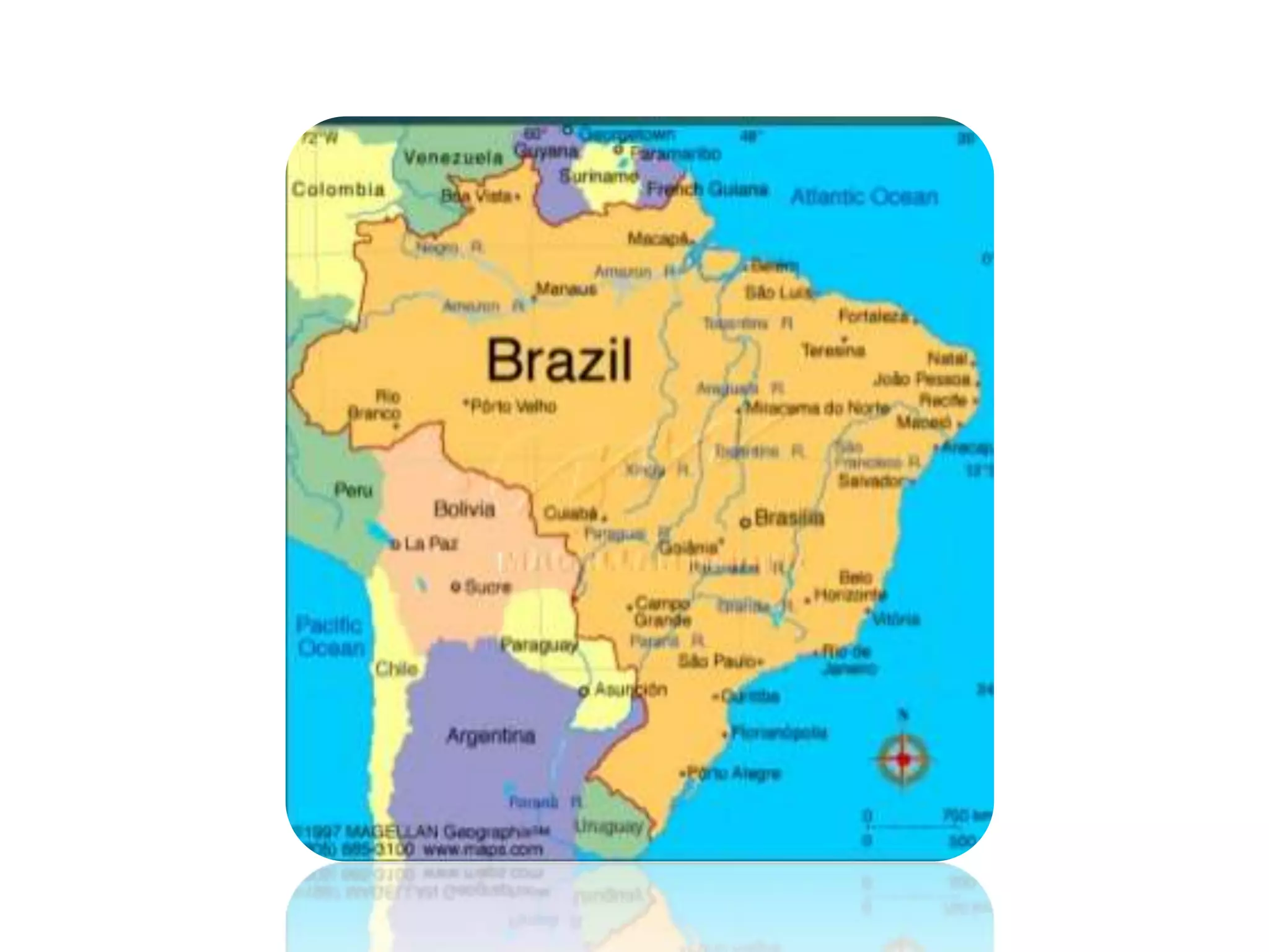
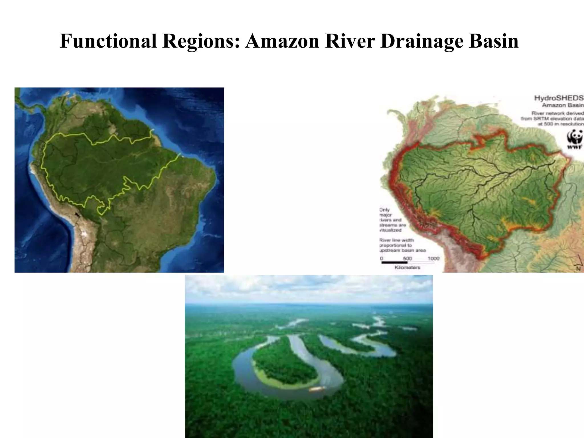
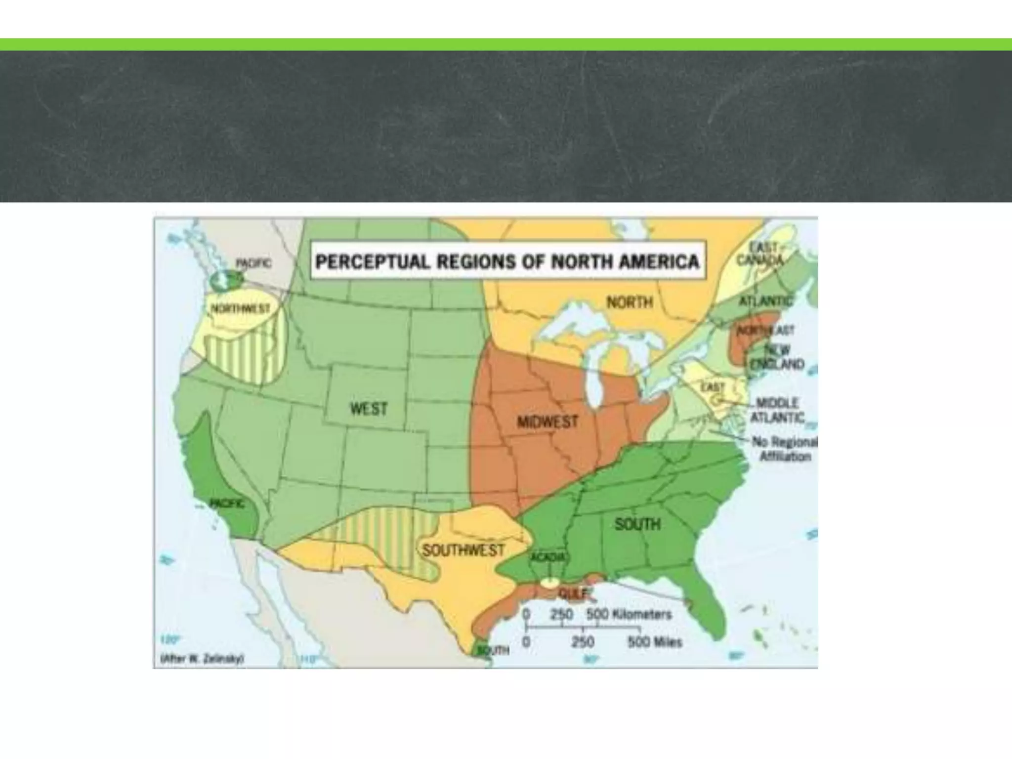
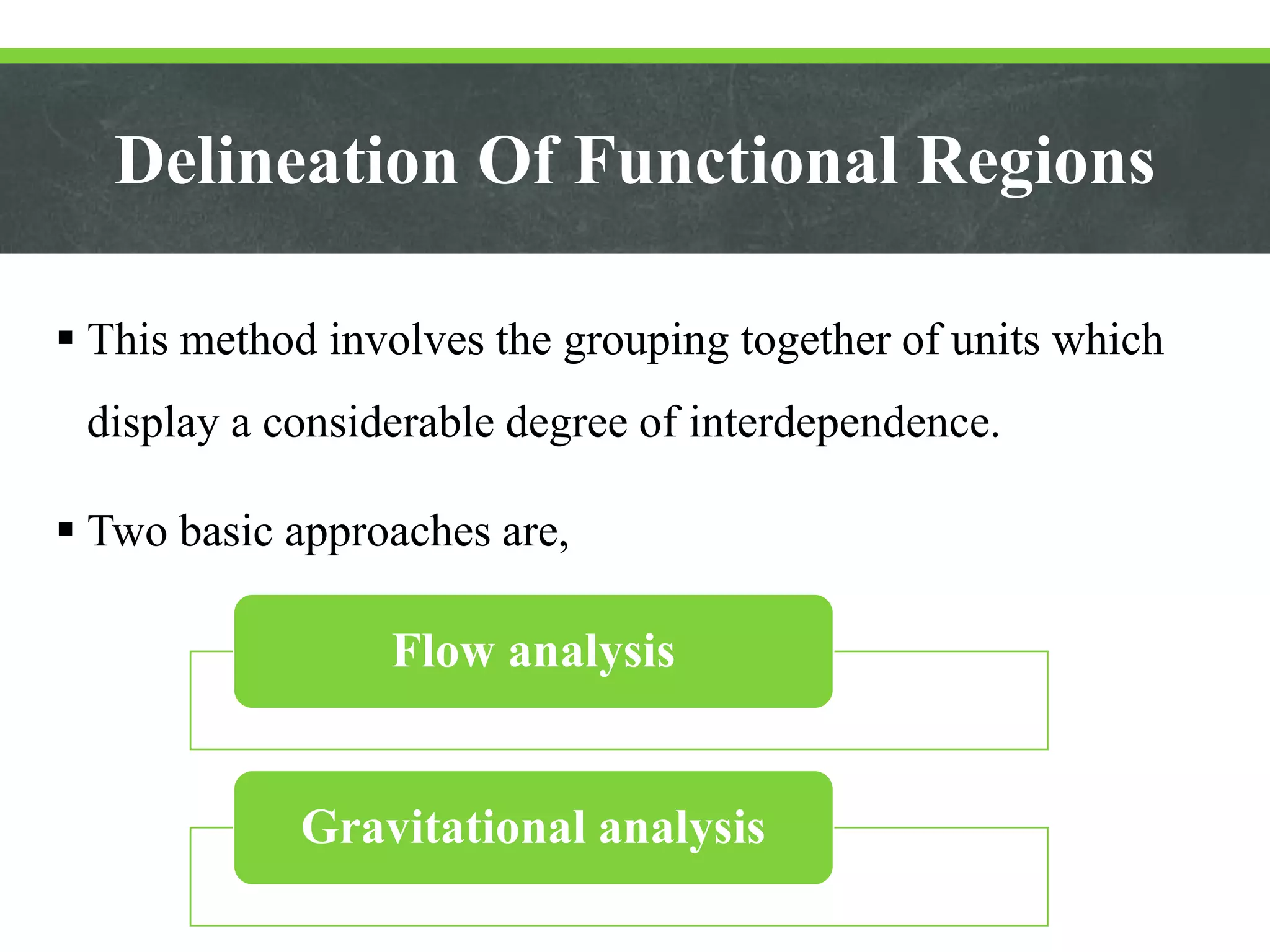
Types and Delineation
of Regions
PRESENTED BY
GAYATHRY SATHEESAN
What’s a Region?
 A region, in the most basic sense, is an area with certain
characteristics that set it apart from other areas.
 These characteristics have distinct qualities about them, such as
climate, size, or populations.
 The boundaries of a certain region are defined by people based
on these different criteria that set them apart from other
regions.
 Regions can easily vary in shape and size and they can be
overlapped with one another or be mutually exclusive.
 Regions can also divide the entire world up into sections or
only reference certain portions of the globe.
Types of Regions
Functional
Formal
Perceptual
A Formal Region
 A formal region is an area that has officially recognized
boundaries defining it.
 As such, formal regions are often made up of the boundaries for
cities, counties, states, and countries.
 These regions are often regarded as common knowledge and
their boundaries set by local or national governments.
 Various criteria like official entity may use to create a region are
political affiliation, nationality, culture, common languages,
religion, geographical features.
 Depending on the chosen criteria, a formal region may be easier
or harder to define.
Functional Region
 A functional region is classified as distinct from other
regions due to certain processes that take place within them.
 This means they are areas that serve a certain function.
 Functional regions are frequently centralized around
economic processes, trade routes, television
networks, transportation, internet connectivity, etc.
 Examples of functional regions include metropolitan
regions, school districts, branch banks, and harbors.
Functional Regions: Amazon River Drainage Basin
Perceptual Region (Vernacular Region)
 A perceptual region is also referred to as a vernacular region.
 Vernacular regions may refer to the different ways that people
communicate with one another, while perceptual regions often
refer to feelings/beliefs about a region held by people.
 Vernacular regions are cultural in nature and reflect how
people within that cultural area have frequently had their own
cultural aspects in addition to their own dialects.
 Vernacular regions are differ from each other by the words
used by its population and the cultural significance attached to
language or practices within that area.
 Since vernacular regions are based partially on
attitudes/perceptions, they are quite malleable and can change
based on shifts in the attitudes/beliefs of people.
Delineation of region
 Regional delineation is the first step in the preparation of
any regional development plan to ensure tentative
operational area of planning.
 With in the planning region the frame of all regional
studies could be undertaken and development envisaged.
Delineation of formal regions
 It involves the grouping together of local units which have
similar characteristics according to certain clearly defined
criteria and which differ significantly from the units outside
the region on the basis of certain chosen criteria.
 The criteria can be unemployment rates, activity rate,
migration trends, per capita income etc.
 The characteristics should differ significantly from units
outside the region.
Variables for delineation of formal region
 Land use characteristics
 Demographic characteristics
 Transport infrastructure
 Social service and public utilities
 Socio-economic structures
 Two techniques for delineation of formal regions are,
Weighted index number methods
Factor analysis
Weighted Index Number Method
 The study area is divided into several localities varying according
to unemployment rates and per capita income levels.
 The aim is to isolate the main problem region; i.e. the area of
economic malaise.
 Weights are assigned to each criteria and when taken together and
weighted, one of the region can be isolated.
Factor Analysis method
 Used for delineating economic health regions.
 Smith identified 14 industrial criteria on a local employment
exchange area base and 14 socio-economic criteria on a local
authority base.
 Many of these criteria are interdependent.
 The factor analysis method can be used to isolate these factors
and to group areas on the basis of factor loadings.
 Smith identified ‘industrial change’ and industrial structure’ as
major industrial factors, and ‘population change’ and ‘social
structure’ as major socio-economic factors.
 These factors help in delineating economic health regions.
Delineation Of Functional Regions
 This method involves the grouping together of units which
display a considerable degree of interdependence.
 Two basic approaches are,
Flow analysis
Gravitational analysis
Flow Analysis Method
 Builds up flows on the basis of the direction and intensity
flows between the dominant center and surrounding
satellites.
 Flows may be of several types: economic (road, rail,
shopping or commuting); social (such as flow of students
or patients); political (flow of govt. expenditure);
information (newspapers, telephone calls), etc.
 Graph theory: measures the relationship (economic, social,
etc) between selected group of centers on the basis of flows
between the centers.
 The no. of telephone calls is the usual flow criteria.
 The flows are plotted in matrix form, from which primary
and secondary flows into and out of each center can be
identified.
Gravitational Analysis Method
 It is concerned with the theoretical forces of attraction
between centers rather than the actual flows.
 This model assumes that the interaction between two centers
is directly proportional to the ‘mass’ of centers and inversely
proportional to the ‘distance’ between them.
 ‘Mass’ is represented by variables like population,
employment, income, expenditure and retail turnover.
 ‘Distance’ is represented in physical terms (miles), time,
price and intervening opportunities.
 By calculating the potential for the centers, lines
illustrating relative attractiveness, spheres of influence
of various centers can be plotted on a map.
 From such lines, functional regions can be identified.
THANK YOU..

Types and delineation of regions ppt

  • 1.
    Types and Delineation ofRegions PRESENTED BY GAYATHRY SATHEESAN
  • 2.
    What’s a Region? A region, in the most basic sense, is an area with certain characteristics that set it apart from other areas.  These characteristics have distinct qualities about them, such as climate, size, or populations.  The boundaries of a certain region are defined by people based on these different criteria that set them apart from other regions.
  • 3.
     Regions caneasily vary in shape and size and they can be overlapped with one another or be mutually exclusive.  Regions can also divide the entire world up into sections or only reference certain portions of the globe.
  • 4.
  • 5.
    A Formal Region A formal region is an area that has officially recognized boundaries defining it.  As such, formal regions are often made up of the boundaries for cities, counties, states, and countries.  These regions are often regarded as common knowledge and their boundaries set by local or national governments.
  • 6.
     Various criterialike official entity may use to create a region are political affiliation, nationality, culture, common languages, religion, geographical features.  Depending on the chosen criteria, a formal region may be easier or harder to define.
  • 10.
    Functional Region  Afunctional region is classified as distinct from other regions due to certain processes that take place within them.  This means they are areas that serve a certain function.  Functional regions are frequently centralized around economic processes, trade routes, television networks, transportation, internet connectivity, etc.
  • 11.
     Examples offunctional regions include metropolitan regions, school districts, branch banks, and harbors.
  • 12.
    Functional Regions: AmazonRiver Drainage Basin
  • 13.
    Perceptual Region (VernacularRegion)  A perceptual region is also referred to as a vernacular region.  Vernacular regions may refer to the different ways that people communicate with one another, while perceptual regions often refer to feelings/beliefs about a region held by people.  Vernacular regions are cultural in nature and reflect how people within that cultural area have frequently had their own cultural aspects in addition to their own dialects.
  • 14.
     Vernacular regionsare differ from each other by the words used by its population and the cultural significance attached to language or practices within that area.  Since vernacular regions are based partially on attitudes/perceptions, they are quite malleable and can change based on shifts in the attitudes/beliefs of people.
  • 16.
    Delineation of region Regional delineation is the first step in the preparation of any regional development plan to ensure tentative operational area of planning.  With in the planning region the frame of all regional studies could be undertaken and development envisaged.
  • 17.
    Delineation of formalregions  It involves the grouping together of local units which have similar characteristics according to certain clearly defined criteria and which differ significantly from the units outside the region on the basis of certain chosen criteria.  The criteria can be unemployment rates, activity rate, migration trends, per capita income etc.  The characteristics should differ significantly from units outside the region.
  • 18.
    Variables for delineationof formal region  Land use characteristics  Demographic characteristics  Transport infrastructure  Social service and public utilities  Socio-economic structures
  • 19.
     Two techniquesfor delineation of formal regions are, Weighted index number methods Factor analysis
  • 20.
    Weighted Index NumberMethod  The study area is divided into several localities varying according to unemployment rates and per capita income levels.  The aim is to isolate the main problem region; i.e. the area of economic malaise.  Weights are assigned to each criteria and when taken together and weighted, one of the region can be isolated.
  • 22.
    Factor Analysis method Used for delineating economic health regions.  Smith identified 14 industrial criteria on a local employment exchange area base and 14 socio-economic criteria on a local authority base.  Many of these criteria are interdependent.  The factor analysis method can be used to isolate these factors and to group areas on the basis of factor loadings.
  • 23.
     Smith identified‘industrial change’ and industrial structure’ as major industrial factors, and ‘population change’ and ‘social structure’ as major socio-economic factors.  These factors help in delineating economic health regions.
  • 24.
    Delineation Of FunctionalRegions  This method involves the grouping together of units which display a considerable degree of interdependence.  Two basic approaches are, Flow analysis Gravitational analysis
  • 25.
    Flow Analysis Method Builds up flows on the basis of the direction and intensity flows between the dominant center and surrounding satellites.  Flows may be of several types: economic (road, rail, shopping or commuting); social (such as flow of students or patients); political (flow of govt. expenditure); information (newspapers, telephone calls), etc.
  • 26.
     Graph theory:measures the relationship (economic, social, etc) between selected group of centers on the basis of flows between the centers.  The no. of telephone calls is the usual flow criteria.  The flows are plotted in matrix form, from which primary and secondary flows into and out of each center can be identified.
  • 27.
    Gravitational Analysis Method It is concerned with the theoretical forces of attraction between centers rather than the actual flows.  This model assumes that the interaction between two centers is directly proportional to the ‘mass’ of centers and inversely proportional to the ‘distance’ between them.  ‘Mass’ is represented by variables like population, employment, income, expenditure and retail turnover.
  • 28.
     ‘Distance’ isrepresented in physical terms (miles), time, price and intervening opportunities.  By calculating the potential for the centers, lines illustrating relative attractiveness, spheres of influence of various centers can be plotted on a map.  From such lines, functional regions can be identified.
  • 29.