This document discusses the benefits of restoring natural drainage systems in Delhi and the impacts of degrading streams. It provides examples of restoring drainage systems in other cities like San Antonio, Texas and Seoul, South Korea. The Cheong Gye Cheon river restoration project in Seoul is highlighted, which uncovered a buried river and created a public park. The document argues for restoring Delhi's drainage channels by daylighting streams and treating wastewater to create linear parks. It outlines policy principles and a strategy for protecting stormwater channels through a Watershed Management Plan and Urban Drainage Master Plan.
Public Private Partnership in Affordable HousingJIT KUMAR GUPTA
Presentation is an attempt to showcase the need and methods of promoting public sector involvement in the Housing to achieve the goal of housing for all by 2022
I came to know regarding this competition from rediff.com
Salient features of a well-designed inclusive Neighbourhood (Colony) for the urban poor is characterized by a well conceptualized effort at social cohesion:
I. Housing Unit and Layouts of Cluster Housing
II. Neighbourhood Colony Layouts
III. Basic Physical Infrastructure (Water Supply, Sanitation, Drainage, Roads, Street Lighting, Solid
Waste Management, etc.)
IV. Cohesive Social Infrastructure (Community Centre, Informal Sector Market, Livelihood Centre,
etc.)
Chennai the fourth largest metropolis in India. Chennai Metropolitan Area (CMA) extends over 1189 sq.km.and comprises of
Chennai Corporation,
16 Municipalities,
20 Town Panchayats and
214 villages covered in 10 Panchayats Unions
It encompasses the Chennai District (176 sq.km.), part of Thiruvallur District (637 sq.km.) and a part of Kancheepuram District (376 sq.km.).
Development control rules,
Maharashtra Regional Town Planning Act,
Land acquisition act,
Village planning: Necessity and principles,
Rural developments- Growth
centre approach, Area Development approach, Integrated rural development
approach.
Nasik city with its rich cultural and historical background has experienced numerous transformations through the several dynasties that reined the city.
Each one of these dynasties and rulers has left an unmistakable imprint on the art, architecture and culture of the place. The transition of the place from a kingdom of Satwahanas to an Industrial town is fascinating
Its rich Architectural heritage includes the preserved caves from Satvahana and various other dynasties; the Hemadpanthi style temples, the famous Wadas from Maratha and Peshwa rulers and last but not least, the magnificent forts protecting the boundaries of the city from enemies.
Even the succeeding periods of British rule and Post Independence era has observed remarkable structures coming up.
This History along with geographical location and geology of the place demonstrates a profound influence on the growth of the townscape.
With Sahyadris in vicinity many forts have been erected during the different empires with their distinctive modes of construction.
River Godavari plays a major role in its development as a religious center; the town has observed the emergence of some beautiful temples with Ghats along its banks.
The rich Architectural style of the structures has been changing as per the eras pertaining to their social, religious and cultural beliefs.
Various rituals and religious philosophies have been evolved due to the development of the society towards the religion, which reveal a grave influence on designs of the structures.
The Post Independence era has perceived a gradual transformation of this dreamlike town into a hybrid-cultured entity.
This paper overviews the time duration of the changed vocabulary of Aesthetics while recording the transformation of an inherently beautiful space into a comparatively characterless townscape.
The presentation is a brief introduction to the road network of Ahmedabad comprising of terminals, nodes, arterial, sub-arterial, collector and local roads. It also provides an intersection detail of Paldi circle as one case study.
The presentation is an attempt to trace the history of Chandigarh Master Plan. It showcases also the making of Chandigarh Capital city and the making of Chandigarh Master Plan-2031
Review of Mumbai Metropolitan regional development planAnoushka Tyagi
The presentation is a Review of the Mumbai Metropolitan regional development plan with respect to the details of the districts, tehsils, population distribution & density, the content of the regional development plan document, administrative setup in the district, the chronology of earlier plans and the SWOT related to the MMR region.
Urban Villages of Delhi: Case study Kotla MubarakpurJoel Michael
Documentation and analysis of surveys and mapping conducted in 3 urban villages of Delhi, namely, Kotla Mubarakpur, Mohammedpur and Hauz Khaz. Comparative analysis of their stages of urbanization and a proposal for Kotla Mubarakpur.
Water conservation by Rainwater Harvesting systems – Treatment of waste water : Physical,Chemical and
Biological methods – Root Zone treatment - Use of recycled water.
Use of Environment friendly materials, Embodied Energy of materials, Bio degradable materials. Recycling
and Reuse of steel, Aluminium and Glass.
To plan a city/region, we require base data on which information extrapolation & decisions may happen. Hence, Identify ‘data needed’, and Identify ‘needs of data’ collection
Inspection survey:
A) Direct :
Observe traffic count/ situation
Observe housing quality
Observe economic activity
Observe social parameters, etc.
B) Indirect:
Clubbing of directly observed ‘indicators’ to generate area’s possible ‘proxy’.
For e.g. housing condition + plot sizes + no. & types of vehicles + consumer goods = income range
. Personal interview/ Dialogue:
A questionnaire is designed beforehand at appropriate scale:
Nominal Scale : Yes or No
Ordinal Scale : Possible options or multiple choice questions
Interval Scale : Range/ intervals like age group or income group
Structured questions are precise and one-way
Semi-structure survey is a two-way information flow. It’s an informal dialogue in which the surveyor might receive new information from respondent/s. however, it depends on;
Behavioural factors of surveyor and respondents
Questions not to be ambiguous or long
Managing conversation and seeking pin-point answers
Judging responses without bias
Recording interview
Avoiding errors
Cross-checking with other respondents
Major land uses to be identified for analysing physical distribution and existing conditions:
Developed
Under-developed
Un-developed
Major uses marked on map are as per the defined regional/city level plans, like;
Urbanizable zone
Industrial zone
Transportation & Communication zone
roads, railways, MRTS, Seaports, Dockyards, Airports, Bus depots/ terminals, freight complexes, transmission and communication
Primary activity zone
Agriculture, poultry, rural settlements, brick kilns, extraction areas
Open area zone
Recreation zone, green buffer zone
Protected/ Eco-sensitive zone
Water bodies, forests, sanctuaries, coastal zone, wetlands, marshy zone
special area zone
Heritage & conservation zone, scenic value, tourism zone, defence area/ zone, border conflict zone
Data regarding demographic characteristics;
Population growth (natural, induced)
Population size (age-wise)
Population density
Population distribution
Gender ratio
Socio-Economic status
Religion
Marital status
Education ratio
School dropouts
Gender-wise enrolment in schools, colleges
Mortality rate (age-wise)
Birth rate
Health rate (in some surveys)
Sample types for doing household/ demographic surveys;
Simple Random sampling
Systematic sampling
Stratified sampling
Cluster sampling
Multistage sampling
There are nine steps involved in the development of a questionnaire:
Decide the information required.
Define the target respondents.
Choose the method(s) of reaching your target respondents.
Decide on question content.
Develop simple & clear wording of questions
Put the questions into a meaningful order and format.
Check the length of the questionnaire.
Pre-test the questionnaire
Develop the final survey form.
Data Compilation and Tabulation
• Data coding is preferred before going on site for survey. This enables uniformity of data collection among all surveyors and helps in speedy data compilation.
• Survey data is then compiled/ tabulated under various required study parameters/ categories like income category, age groups, hourly water supply, O/D survey, traffic volume, etc.
• These tables are then ready for further graphical representation and analysis.
Graphical presentation of data: pie chart, line chart, bar chart, pyramid graphs, histograms, Lorenz curve, scalogram, sociogram
Data analysis- Quantitative and Qualitative
Land suitability Analysis
Population- Economic Analysis
• Relationship between human capital and city’s economy
• Relationship between humans and resource consumption
Population pattern and its analysis
Density : Density is an objective and quantitative measure referring to a spatial fact that is typically calculated from the ratio of persons or housing units per surface unit.
Residential and non-residential population
Definition of map: diagrammatic representation of reality on a paper.
elements of a map: scale, direction, title, subtitle, ownership, key map, legend
contents of base map: boundaries
network, topography, landuse, contours, utilities
appropriate scales for various types of plan like regional plan, perspective plan, development plan, local area plan
measurement of sclaes: scale conversion from larger unit to smaller units and vice-versa
Landuse classification, Landuse Landcover (LULC) classification
“At the end of the day if you have a city that is livable, sustainable, resilient, and competitive, but which is not inclusive, then something is fundamentally wrong in that city”, Sameh Wahba, World Bank.
Inclusive planning is a process of development that includes wide variety of people and activities. It includes various dimensions of urban and rural poverty such as income and social poverty, environmental poverty, health poverty and education poverty.
Equity means “The quality of being fair and impartial”
Question)
Why social inclusion is relevant for cities & citizens?
Answer)
1. Improves livability and cohesion: Inclusive cities eliminate spatial fragmentation, embrace mix-development, respect differences, and create the right environment supported by infrastructure for everyone to thrive. For example, to make the London public transport network convenient and more accessible, the Royal London Society for Blind People created a Wayfindr to enable visually-impaired people to move independently through their various environments
2. Enhances economic competitiveness and productivity of cities: well-integrated and frequent interaction between stakeholders results in enhanced productivity and economic growth for all communities.
3. Improves resilience: By creating a connected and inclusive physical and digital infrastructure, cities can give their residents access to an improved range of shared services, achieving joint economies of scale and accelerating prosperity. Inclusive cities also provide opportunities to expand knowledge sharing, promoting collaboration across the entire population, which in turn builds a more resilient society.
This presentation is about Urban Development Policy and related programmes/ missions running in India.
'Public policy provides signals and sets the regulatory and institutional framework that influence the actions of all actors including private investors and consumers.', UN Conference on Climate Change 2021.
This presentation brief about National Urban Policy Framework, 2018 and the talks about various policies running for various sectors int the year 2022, like the Economic sector, Housing sector, Transport sector, Infrastructure, Industry, Informal sector, Tourism, Environment and Climate Change.
Region: A territorial area of similar characteristics, which is bigger than local area and smaller than the country / nation,
Regions in India, city region & linkages like economic, functional and transportation,
Rural-Urban Linkage,
Rural-Urban Fringe,
Urban periphery settlements: Urban Village and Unauthorised colony/ illegal-land sub-division,
Land Ceiling Repeal Act 1999
According to UN Habitat in 2015, Cities use 2% of the earth's land
Cities consume about 78% of global energy
Produce > 60% of carbon emissions
Produce > 70% of global waste
Consume > 75% of the world’s natural resources.
Climate change includes both global warming driven by human-induced emissions of greenhouse gases and the resulting large-scale shifts in weather patterns.
this presentation is about city's sustainability- environment and economic. It talks of United Nations' Sustainable Development Goals. It defines the concept of Economic sustainability and environment sustainability in a city.
This presentation is about URBAN GROWTH AND SYSTEMS OF CITIES:
City is for all!
City perspective differs for different class of people!
Every city has its own dynamics!
City growth is planned, yet its uncertain!
Limited resources are usually seen as unlimited!
Unplanned growth trends give reality checks!
Planned and unplanned sectors intertwin in cities!
It includes the identification and classification of urban settlements, itheir complexity, and their role in a country & its GDP
Lack of Cultural Significance in Social Housing for Shiites in IndiaIram Aziz
Shiite Muslims, world over, is the second largest sect of Muslims which have different traditions than Sunni Muslims and so do their housing needs. In democratic country like India, Muslims are usually found settled in homogeneous groups, largely viewed as religious ghettos. This paper highlights the issues behind the formation of these ghettos where such settlements come up not due to the economic disparity, as a usual case, but it’s often the result of lack in provision for cultural or institutional needs. Through the case example of Lucknow city- a place of majority of Shiite habitation, this paper will discuss the needs of Shiite Muslims into the neighbourhood planning, so that they are no more being marginalised into the city planning/ urban design.
This paper focuses on the traditional Indian Shiite housing in the light of policy parameters of the Islamic housing, cultural parameters of the sect, and the transformation over time due to urbanisation. For analysing the sect’s urban habitation, this paper discusses about community’s requirements acting as determinant for shaping their neighbourhoods and dwelling units, making their housing different from any other social housing.
Based on the studies & observations, an attempt is made to reduce the gap between the information and the practice of neighbourhood design. It contributes towards the social sustainability by securing concept of ‘housing for all’ incorporating the community needs, and also secures from undue pressure on ecological resources by channelizing the required housing type
Brief deliberation on the concept of slum and the urban poor! This presentation talks of the slum condition and not particular the type of settlement like squatter or urban village or old city etc.
Unit 8 - Information and Communication Technology (Paper I).pdfThiyagu K
This slides describes the basic concepts of ICT, basics of Email, Emerging Technology and Digital Initiatives in Education. This presentations aligns with the UGC Paper I syllabus.
Palestine last event orientationfvgnh .pptxRaedMohamed3
An EFL lesson about the current events in Palestine. It is intended to be for intermediate students who wish to increase their listening skills through a short lesson in power point.
June 3, 2024 Anti-Semitism Letter Sent to MIT President Kornbluth and MIT Cor...Levi Shapiro
Letter from the Congress of the United States regarding Anti-Semitism sent June 3rd to MIT President Sally Kornbluth, MIT Corp Chair, Mark Gorenberg
Dear Dr. Kornbluth and Mr. Gorenberg,
The US House of Representatives is deeply concerned by ongoing and pervasive acts of antisemitic
harassment and intimidation at the Massachusetts Institute of Technology (MIT). Failing to act decisively to ensure a safe learning environment for all students would be a grave dereliction of your responsibilities as President of MIT and Chair of the MIT Corporation.
This Congress will not stand idly by and allow an environment hostile to Jewish students to persist. The House believes that your institution is in violation of Title VI of the Civil Rights Act, and the inability or
unwillingness to rectify this violation through action requires accountability.
Postsecondary education is a unique opportunity for students to learn and have their ideas and beliefs challenged. However, universities receiving hundreds of millions of federal funds annually have denied
students that opportunity and have been hijacked to become venues for the promotion of terrorism, antisemitic harassment and intimidation, unlawful encampments, and in some cases, assaults and riots.
The House of Representatives will not countenance the use of federal funds to indoctrinate students into hateful, antisemitic, anti-American supporters of terrorism. Investigations into campus antisemitism by the Committee on Education and the Workforce and the Committee on Ways and Means have been expanded into a Congress-wide probe across all relevant jurisdictions to address this national crisis. The undersigned Committees will conduct oversight into the use of federal funds at MIT and its learning environment under authorities granted to each Committee.
• The Committee on Education and the Workforce has been investigating your institution since December 7, 2023. The Committee has broad jurisdiction over postsecondary education, including its compliance with Title VI of the Civil Rights Act, campus safety concerns over disruptions to the learning environment, and the awarding of federal student aid under the Higher Education Act.
• The Committee on Oversight and Accountability is investigating the sources of funding and other support flowing to groups espousing pro-Hamas propaganda and engaged in antisemitic harassment and intimidation of students. The Committee on Oversight and Accountability is the principal oversight committee of the US House of Representatives and has broad authority to investigate “any matter” at “any time” under House Rule X.
• The Committee on Ways and Means has been investigating several universities since November 15, 2023, when the Committee held a hearing entitled From Ivory Towers to Dark Corners: Investigating the Nexus Between Antisemitism, Tax-Exempt Universities, and Terror Financing. The Committee followed the hearing with letters to those institutions on January 10, 202
Honest Reviews of Tim Han LMA Course Program.pptxtimhan337
Personal development courses are widely available today, with each one promising life-changing outcomes. Tim Han’s Life Mastery Achievers (LMA) Course has drawn a lot of interest. In addition to offering my frank assessment of Success Insider’s LMA Course, this piece examines the course’s effects via a variety of Tim Han LMA course reviews and Success Insider comments.
The French Revolution, which began in 1789, was a period of radical social and political upheaval in France. It marked the decline of absolute monarchies, the rise of secular and democratic republics, and the eventual rise of Napoleon Bonaparte. This revolutionary period is crucial in understanding the transition from feudalism to modernity in Europe.
For more information, visit-www.vavaclasses.com
Welcome to TechSoup New Member Orientation and Q&A (May 2024).pdfTechSoup
In this webinar you will learn how your organization can access TechSoup's wide variety of product discount and donation programs. From hardware to software, we'll give you a tour of the tools available to help your nonprofit with productivity, collaboration, financial management, donor tracking, security, and more.
Acetabularia Information For Class 9 .docxvaibhavrinwa19
Acetabularia acetabulum is a single-celled green alga that in its vegetative state is morphologically differentiated into a basal rhizoid and an axially elongated stalk, which bears whorls of branching hairs. The single diploid nucleus resides in the rhizoid.
2. Advantages of having natural drainage
systems
1. Support of riparian and wetland vegetation.
2. Creation of habitat for wildlife and aquatic species.
3. Slowing down and attenuating floodwater by spreading out flows over vegetated
overbanks.
4. Promotion of infiltration and groundwater recharge.
5. Enhancement of water quality.
6. Provision of corridors for trails and open space.
7. Enhancement of property values and quality of life.
3. FUNCTIONS AND BENEFITS OF HEALTHY STREAMS
Source: Douglas County Storm Drainage Design and Technical Criteria Manual
4. IMPACTS OF STREAM DEGREDATION
Source: Douglas County Storm Drainage Design and Technical Criteria Manual
5. Adverse affects of Destroying natural
drainage systems
1. Environmentally bad decision as the problem gets out of sight-out of mind-not solving
the problem!
2. The concrete slab effectively stops groundwater recharge.
3. The slab cover over the nala shall aggravate the ‘heat island’ effect.
4. The siltation in the drain shall become difficult and more expensive to manage and
would require specialised super-suction machines.
5. The sewage being carried by the drain shall be deprived of sunlight and
oxygen, creating septic conditions and effectively increase the pollution load on the
river.
6.
7. Alternatively…
1. The drains could use on-line decentralised biological wastewater treatment to treat the
waste water and reuse the same for irrigation and create a landscaped parkway like
‘OSHO PARK’ in Pune.
2. The sanitised drain then could be used for creating picnic hubs, jogger’s park, a NMT
connection to achieve interconnectivity between various residential neighbourhoods,
etc.
Before
Case example: Osho Park, Pune
After
10. Barapullah Nallah corridor - Before
http://www.greenlightdhaba.org/2011/04/wrong-turn-at-barapullah-nallah.html
11. Barapullah Nallah corridor - After
http://www.greenlightdhaba.org/2011/04/wrong-turn-at-barapullah-nallah.html
12.
13. Undo the mistakes.…
Restoration/Daylighting of Natural Drainage systems
Daylighting refers to projects that uncover and restore streams and
rivers previously buried in underground pipes and culverts, covered by
decks, or otherwise removed from view.
Source: http://www.sf-planning.org/ftp/files/Citywide/Glen_Park/PUC_Daylighting_FAQ_and_Case_Studies.pdf
21. Timeline of Cheong Gye Cheon river stream
Named Cheong gye cheon meaning
clear water stream
Construction of road/ highway/freeway
over polluted streams
1970
1300
2011
1945
Shanty towns along polluted & open
sewage channels for city
Stream restored to its ecological function
http://didacticdiscourse.wordpress.com/2012/03/29/reclaiming-nature-in-the-city-cheong-gye-cheon-restoration/
22. Timeline of Delhi water channels
Settlement along water channel
Construction of road/ highway over
polluted streams
2010
1200
1945
Slums along natural drainage channels &
open sewage channels for city
-------
?
23. Policy principles required…
Source: Urban Drainage and Flood Control District (Colorado), 2001
A natural drain policy must highlight followed principles;
1. Drainage is a regional phenomenon that does not respect the boundaries between
government jurisdictions or between properties.
2. A storm drainage system is a subsystem of the total urban water resource system.
3. Every urban area has an initial and a major drainage system, whether or not they are actually
planned and designed.
4. Runoff routing is primarily a space allocation problem.
5. Planning and design of storm water drainage systems generally should not be based on the
premise that problems can be transferred from one location to another.
6. An urban storm drainage strategy should be a multi-objective and multi-means effort.
7. Design of the storm water drainage system should consider the features and functions of the
existing drainage system.
8. In new developments, attempts should be made to reduce storm water runoff rates and
pollutant load increases after development to the maximum extent practicable.
9. The storm water management system should be designed, beginning with the outlet or point
of outflow from the project, giving full consideration to downstream effects and the effects of
off-site flows entering the system.
10. The storm water management system should receive regular maintenance.
11. Floodplains need to be preserved whenever feasible and practicable.
12. Reserve sufficient right-of-way to permit lateral channel movement whenever the floodplain
is contained within a narrow natural channel. Urban Drainage and Flood Control District
(Colorado), 2001
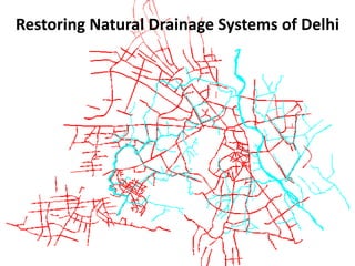
24. Strategy for protecting and restoring storm water channels
Create City level Watershed Management Plan (WMP) and
Urban Drainage Master Plan
Typical Watershed Map of a City, with multiple watersheds
Watershed map using Digital
Elevation Model (DSSDI)