Problems in metropolitan cities graduate report under smart metropolitan planning subject in masters of Town and Country planning. 11 major problems of metropolitan cities in India
Land use and land value theory ppt
William Alonso In location theory William Alonso (Location and Land Use: Toward a General Theory of Land Rent, 1964) built upon the Thünen model to account for intra-urban variations in land use. He attempted to apply accessibility requirements to the city centre for various types of land use (housing, commercial,…
land use and land value theory of william alonso ppt
william alonso
REGIONAL PLAN: A CASE OF MUMBAI METROPOLITAN REGIONYash Shah
Regional planning deals with the efficient placement of land-use activities, infrastructure, and settlement growth across a larger area of land than an individual city or town. Regional planning is a sub-field of urban planning as it relates land use practices on a broader scale. It also includes formulating laws that will guide the efficient planning and management of such said regions.
Regions require various land uses; protection of farmland, cities, industrial space, transportation hubs and infrastructure, military bases, and wilderness. Regional planning is the science of efficient placement of infrastructure and zoning for the sustainable growth of a region. Advocates for regional planning such as new urbanist Peter Calthorpe, promote the approach because it can address region-wide environmental, social, and economic issues which may necessarily require a regional focus.
A ‘region’ in planning terms can be administrative or at least partially functional, and is likely to include a network of settlements and character areas. In most European countries, regional and national plans are ‘spatial’ directing certain levels of development to specific cities and towns in order to support and manage the region depending on specific needs, for example supporting or resisting polycentrism.
The Mumbai Metropolitan Planning Committee (MMPC) was formed under the provisions of the Maharashtra Metropolitan Planning Committee Act 1999 and has been entrusted with the task of preparing a Regional Plan for the Mumbai Metropolitan Area with help from MMRDA. Currently, the Regional Plan 1996 is in operation which was prepared by the Mumbai Metropolitan Region Development Authority (MMRDA) and sanctioned in 1999. The MMRDA was established under the MMRDA Act, 1974 and undertook the revision of the First regional plan prepared by the Regional Planning Board and sanctioned in 1973, under the provisions of the MR& TP Act, 1966.
Growth pattern of towns Natural and Planned,
Types of zoning and importance,
various road networks(Grid iron pattern, shoe string development,
Surveys for data collection, physical survey, social survey, economic survey, civic survey,
Town aesthetics, landscape architecture,
Rehabilitation of slum and urban renewal,
Urban Management & Governance Structures in IndiaRavikant Joshi
This PPT delivered to Scholars of Indian School of Public Policy explains various urban management and governance structure found in various States and urban local bodies of India and their limitations
Review of Development Plans/ Master Plans of selected cities of India.KARTHICK KRISHNA
This is an academic assignment done for the purpose to draft a master plan/ development plan. This helps us to identify the concept and context of the various plans and its development proposals applicability and replicability.
Theories and models for Regional planning and developmentKamlesh Kumar
This is a work on the major theories of Regional planning mainly consisting the work of Francois Perroux, Gunnar Myrdal, Albert O. Hirschman, Walter Whitman Rostow and John Friedman.
Large parts of rural areas in India are not stand-alone settlements but part of a cluster of settlements, which are relatively proximate to each other. These clusters typically illustrate potential for growth, have economic drivers and derive locational and competitive advantages. Hence, making a case for concerted policy directives for such clusters. These clusters once developed can then be classified as 'Rurban'. Hence taking cognizance of this, the Government of India, has proposed the Shyama Prasad Mukherji Rurban Mission (SPMRM), aimed at developing such rural areas by provisioning of economic, social and physical infrastructure facilities.
To plan a city/region, we require base data on which information extrapolation & decisions may happen. Hence, Identify ‘data needed’, and Identify ‘needs of data’ collection
Inspection survey:
A) Direct :
Observe traffic count/ situation
Observe housing quality
Observe economic activity
Observe social parameters, etc.
B) Indirect:
Clubbing of directly observed ‘indicators’ to generate area’s possible ‘proxy’.
For e.g. housing condition + plot sizes + no. & types of vehicles + consumer goods = income range
. Personal interview/ Dialogue:
A questionnaire is designed beforehand at appropriate scale:
Nominal Scale : Yes or No
Ordinal Scale : Possible options or multiple choice questions
Interval Scale : Range/ intervals like age group or income group
Structured questions are precise and one-way
Semi-structure survey is a two-way information flow. It’s an informal dialogue in which the surveyor might receive new information from respondent/s. however, it depends on;
Behavioural factors of surveyor and respondents
Questions not to be ambiguous or long
Managing conversation and seeking pin-point answers
Judging responses without bias
Recording interview
Avoiding errors
Cross-checking with other respondents
Major land uses to be identified for analysing physical distribution and existing conditions:
Developed
Under-developed
Un-developed
Major uses marked on map are as per the defined regional/city level plans, like;
Urbanizable zone
Industrial zone
Transportation & Communication zone
roads, railways, MRTS, Seaports, Dockyards, Airports, Bus depots/ terminals, freight complexes, transmission and communication
Primary activity zone
Agriculture, poultry, rural settlements, brick kilns, extraction areas
Open area zone
Recreation zone, green buffer zone
Protected/ Eco-sensitive zone
Water bodies, forests, sanctuaries, coastal zone, wetlands, marshy zone
special area zone
Heritage & conservation zone, scenic value, tourism zone, defence area/ zone, border conflict zone
Data regarding demographic characteristics;
Population growth (natural, induced)
Population size (age-wise)
Population density
Population distribution
Gender ratio
Socio-Economic status
Religion
Marital status
Education ratio
School dropouts
Gender-wise enrolment in schools, colleges
Mortality rate (age-wise)
Birth rate
Health rate (in some surveys)
Sample types for doing household/ demographic surveys;
Simple Random sampling
Systematic sampling
Stratified sampling
Cluster sampling
Multistage sampling
There are nine steps involved in the development of a questionnaire:
Decide the information required.
Define the target respondents.
Choose the method(s) of reaching your target respondents.
Decide on question content.
Develop simple & clear wording of questions
Put the questions into a meaningful order and format.
Check the length of the questionnaire.
Pre-test the questionnaire
Develop the final survey form.
Planning and Urban Management-issues & challenges Subodh Shankar
With more and more people shifting to urban areas, the management issues of urban areas are getting complex day by day- posing serious challenges to urban planners and city managers. The slides, with the help of the case study of Curitiba(Brazil), discuss how an architect turned politician, through his innovative approaches solved the complex urban issues in most economical way.
In context of India n comparing it with the world. The presentation defines these concepts with apt case studies from various countries and India as well..
Strategies for Development of Peri Urban Areas in a Developing Country A Case...ijtsrd
The world is experiencing a new phenomena – peri urbanism. As the population is increasing and cities are infrastructurally upgraded, there has been a gradual shift of the urban population from the more developed regions to the less developed ones, aimed at availing free open spaces to live, grow and setting up new communities. This movement of urban population in large numbers has led to formation of peri urban spaces. With no such boundary to define the peri urban spaces, these areas are the outskirts of the urban centres which are to be explored. A detailed understanding about the dynamics of urbanisation is necessary for coping with the negative effects poised by urban sprawling on the peri urban areas. Being designated as one of the first smart city of India, Bhubaneswar city is experiencing formation of urban sprawls around the major urban nodes. In order to further examine the need for policy formulation, a detailed study has been done to understand the demographic, economic and social profile of the inhabitants residing within the fringe areas of Bhubaneswar. The emperical approach of the paper is based on the study of the infrastructure and development issues of the area using remote sensing and GIS techniques. The final findings of the study includes the issues, problems and recommendations to be applicable for a planned and controlled development in the peri urban areas of Bhubaneswar. Leena Sahoo | Swapna Sarita Swain "Strategies for Development of Peri-Urban Areas in a Developing Country (A Case Study of Bhubaneswar)" Published in International Journal of Trend in Scientific Research and Development (ijtsrd), ISSN: 2456-6470, Volume-5 | Issue-4 , June 2021, URL: https://www.ijtsrd.compapers/ijtsrd42350.pdf Paper URL: https://www.ijtsrd.comengineering/architecture-and-planning/42350/strategies-for-development-of-periurban-areas-in-a-developing-country-a-case-study-of-bhubaneswar/leena-sahoo
SMART CITY: FEATURES THAT MAKE A CITY ‘SMART’”Yash Shah
Cities are engines of growth for the economy of every nation, including India. Nearly 31% of India’s current population lives in urban areas and contributes 63% of India’s GDP (Census 2011). With increasing urbanization, urban areas are expected to house 40% of India’s population and contribute 75% of India’s GDP by 2030. This requires comprehensive development of physical, institutional, social and economic infrastructure. All are important in improving the quality of life and attracting people and investments to the City, setting in motion a virtuous cycle of growth and development. Development of Smart Cities is a step in that direction.
The first question is what is meant by a ‘smart city’. The answer is, there is no universally accepted definition of a smart city. It means different things to different people. The conceptualisation of Smart City, therefore, varies from city to city and country to country, depending on the level of development, willingness to change and reform, resources and aspirations of the city residents.
Smart Cities Mission is an urban renewal and retrofitting programme launched by the Government of India on June 25, 2015 with a mission to develop 100 cities all over the country making them citizen friendly and sustainable (Government of India 2015). Each of the 100 Smart Cities will get Rs 100 crore every year for five years, with an equal contribution coming from the respective state government and the urban local body combined. The Mission is carried out through special purpose vehicles (SPVs), registered under the Companies Act, 2013.
A smart city would have a different connotation in India than, say, Europe. Even in India, there is no one way of defining a smart city. Some definitional boundaries are required to guide cities in the Mission. In the imagination of any city dweller in India, the picture of a smart city contains a wish list of infrastructure and services that describes his or her level of aspiration. To provide for the aspirations and needs of the citizens, urban planners ideally aim at developing the entire urban eco-system, which is represented by the four pillars of comprehensive development-institutional, physical, social and economic infrastructure. This can be a long term goal and cities can work towards developing such comprehensive infrastructure incrementally, adding on layers of ‘smartness’.
AFFORADBLE HOUSING SHORTAGE IN INDIA: - A CASE STUDY OF SURATYash Shah
Causes of Housing Shortage in India can be list out as following:
• Rapid population growth
• Migration
• Urbanization
• Limited land supply
• Affordability
• War and Violence
• Lack of financing etc
Affordable housing is defined as any housing that meets some form of affordability criterion.
The affordability criterion is different for different countries. For example in United States
and Canada, a common accepted criterion for affordable housing is that the cost of housing
should not be more than 30 percent of a household's gross income. Housing costs include
taxes and insurance for owners, and utility costs.
A Review of Smart Cities Evolution in India vivatechijri
In order to improve the quality of life for people, smart cities are a modern urban concept. Various
smart technologies are grouped together in order to increase the comfort of human life. This paper highlights the
various technologies that are merged together for building a smart city in a developing country like India. Another
major aspect of the paper focuses on the kind of technological combinations and their effects used to plan and
build a smart city. Finally, the paper concludes by providing an overview of the present status and various
challenges faced during the development of smart cities in the Indian scenarios.
Panchayats have been the backbone of the Indian villages since the beginning of recorded history. Gandhiji, the father of the nation, in 1946 had aptly remarked that the Indian Independence must begin at the bottom and every village ought to be a Republic or Panchayat having powers. Gandhiji dream has been translated into reality with the introduction of the three-tier Panchayati Raj system to ensure people’s participation in rural reconstruction.
An integrated local area plan, based on specific needs of each area, was stressed upon from the beginning of plan development process in 1950s. However, despite several reports and studies, there were only sporadic efforts and isolated cases of such planning.
The passage of the Constitution (73rd Amendment) Act, 1992 marks a new era in the federal democratic set up of the country and provides constitutional status to the Panchayati Raj Institutions (PRIs). These PRIs are empowered to function as institutions of Self Government and to prepare plans for economic development and social justice and their empowerment. The PRIs constitute the bedrock for the implementation of most of Rural Development Programmes.
Panchayati Raj system of governance provides a 3-tier structure of local governance in which Gram Panchayats are the basic units of administration. The three-tiers include the following: Gram Panchayat, Block Panchayat, and District Panchayat. Panchayats are responsible for the preparation of plans for economic development and social justice; implementation of national schemes; and to levy and collect appropriate taxes, duties, tolls and fees.Govt. of India has elaborated a detailed picture of District Planning through their publication "Manual for Integrated District Planning". This manual will provide guidance in the task of preparing District Plans that are based on a long-term vision, reflect the needs of the people and provide a framework for convergence of programmes and resources so that implementation of the plan yields optimal outcomes and helps address regional imbalances, with a view of bringing all areas of the country into a twenty-first century vision of development.
“District Planning” is the process of preparing an integrated plan for the Local Government in a District taking into account the resources available and covering the sectoral activities and schemes assigned to the district level below and those implemented through local governments in the state.” It ensures better delivery of services and efficient use of resources
India Smart Cities Infrastructure Investment OutlookKuicK Research
“India Smart Cities Infrastructure Investment Outlook” Report Highlights:
• Introduction to Smart City
• Core Components of Smart City
• Aspects of Smart City Infrastructure
• Smart Cities in India
• Key Trends in Smart City Development
• Government Support and Policy Outline
• India Smart Cities Infrastructure Guidelines
• India Smart Cities Project Future Outlook
Smart City Mission is an urban renewal and retrofitting program by the Government of India under Prime Minister Narendra Modi’s vision.
In my opinion, this PDF doesn't need too much of a description, the PDF itself is full of information collected from the Authentic Government Site of Smart City Mission http://smartcities.gov.in/
Government of India plans to develop Multi-modal High Axle Load Dedicated Freight Corridor (DFC) between Delhi and Mumbai, covering an overall length of 1483km, with end terminals at Tughlakabad and Dadri in the National Capital Region of Delhi and Jawaharlal Nehru Port at Mumbai.
Government of India has further proposed establishing, promoting and facilitating “Delhi Mumbai Industrial Corridor (DMIC) along the alignment of DFC between Delhi and Mumbai. The objective of DMIC, supported by world-class infrastructure, would be to optimize on the present potential, enhance investment climate and promote the economic development of the region through creation of a long term enabling environment.
An MOU relating to the DMIC has been signed between the Ministry of Economy, Trade and Industry (METI) of Japan and the Ministry of Commerce and Industry (MoCI) of India to explore the opportunities for mutual cooperation. MoCI has further initiated the process by appointing M/s IL&FS Infrastructure Development Corporation Limited (IIDC), New Delhi as Consultant for preparation of conceptual framework for DMIC.
Smart Cities: Smarter Solutions for better tomorrowResurgent India
It is estimated that by 2030, 40% of India’s population will be living in urban areas and contributing 75% of GDP. On account of the ongoing rural-to-urban migration, an estimated 400 million people are expected to migrate to cities over the next 15 years.
The aim of the Mission Smart City is to efficiently utilise the available Assets, Resources and
Infrastructure to enhance the quality of Urban Life and provide a clean and sustainable
environment for living and the main focus will be on core infrastructure services like adequate
clean Water supply, Power supply, Sanitation, Disaster Management, Solid waste management,
Waste water treatment, Efficient urban mobility and Public Transportation, Public Healthcare
system, Education, Affordable Housing, robust IT connectivity, e-governance, Safety, Socialsecurity. Smart City needs Smart Citizens too, Smart City needs to be Safe City as well for
citizens live a smooth life.
Some definitional boundaries are required to guide cities in the Mission. In the imagination of
any city dweller in India, the picture of a Smart City contains a wish list of infrastructure and
services that describes his or her level of aspiration. To provide for the aspirations and needs of
the citizens, urban planners ideally aim at developing the entire urban eco-system, which is
represented by the four pillars of comprehensive development — institutional, physical, social
and economic infrastructure. This can be a long term goal and cities can work towards
developing such comprehensive infrastructure incrementally, adding on layers of ‘smartness’.
In the approach to the Smart Cities Mission, the objective is to promote cities that provide core
infrastructure and give a decent quality of life to its citizens, a clean and sustainable environment
and application of ‘Smart’ Solutions. The focus is on sustainable and inclusive development and
the idea is to look at compact areas, create a replicable model which will act like a light house to
other aspiring cities. The Smart Cities Mission of the Government is a bold, new initiative. It is
meant to set examples that can be replicated both within and outside the Smart City, catalyzing
the creation of similar Smart Cities in various regions and parts of the country.
In Smart Cities Mission Vadodara 2nd in PPP projects' progress Vadodara, which was selected to
be part of the Smart Cities Mission in September 2016, had zeroed in on 62 projects worth Rs
2,817 crore in this regard. The Union Ministry of Housing and Urban Affairs had launched the
India Smart Cities Award on 25 June, 2017 with an objective to reward cities, projects and
innovative ideas.
"Smart Utilization of Vadodara City's Potential for enhancing Quality of life for the citizens of
Providing Equal Access to Best Quality Physical Infrastructure, Social Infrastructure and
Mobility through leveraging state of the art technology; thus making Vadodara a Futuristic
Global city with focus on enhancing economy, protecting the ecology and preserving the identity
& culture of the city".
What exactly is a Smart City- Features, Choice, & More.pdfyamunaNMH
The Smart City Mission was introduce by the Indian government in 2015. In 100 cities around the nation, the goal was to boost economic growth and infrastructure. The goal also aspires to build replicas of these cities that can serve as an example for other communities around the nation to emulate in order to become “Smart” cities. The Smart City mission aids society in overcoming environmental and socioeconomic problems in metropolitan areas.
Urban heritage conservation , India under the subject of urban planning and techniques in town and country planning with international and national level contribution , its need and case of heritage walk of Ahmadabad city.
-Definitions related to Urban Conservation
-Important of Heritage conservation
-Conservation Elements
-Conservation at International Level
-Conservation at National Level
-Constitution Obligation
-Acts for Conservation
-Need of Urban Heritage Conservation
-Heritage walk of Ahmedabad City
How to Split Bills in the Odoo 17 POS ModuleCeline George
Bills have a main role in point of sale procedure. It will help to track sales, handling payments and giving receipts to customers. Bill splitting also has an important role in POS. For example, If some friends come together for dinner and if they want to divide the bill then it is possible by POS bill splitting. This slide will show how to split bills in odoo 17 POS.
The Indian economy is classified into different sectors to simplify the analysis and understanding of economic activities. For Class 10, it's essential to grasp the sectors of the Indian economy, understand their characteristics, and recognize their importance. This guide will provide detailed notes on the Sectors of the Indian Economy Class 10, using specific long-tail keywords to enhance comprehension.
For more information, visit-www.vavaclasses.com
Instructions for Submissions thorugh G- Classroom.pptxJheel Barad
This presentation provides a briefing on how to upload submissions and documents in Google Classroom. It was prepared as part of an orientation for new Sainik School in-service teacher trainees. As a training officer, my goal is to ensure that you are comfortable and proficient with this essential tool for managing assignments and fostering student engagement.
Synthetic Fiber Construction in lab .pptxPavel ( NSTU)
Synthetic fiber production is a fascinating and complex field that blends chemistry, engineering, and environmental science. By understanding these aspects, students can gain a comprehensive view of synthetic fiber production, its impact on society and the environment, and the potential for future innovations. Synthetic fibers play a crucial role in modern society, impacting various aspects of daily life, industry, and the environment. ynthetic fibers are integral to modern life, offering a range of benefits from cost-effectiveness and versatility to innovative applications and performance characteristics. While they pose environmental challenges, ongoing research and development aim to create more sustainable and eco-friendly alternatives. Understanding the importance of synthetic fibers helps in appreciating their role in the economy, industry, and daily life, while also emphasizing the need for sustainable practices and innovation.
We all have good and bad thoughts from time to time and situation to situation. We are bombarded daily with spiraling thoughts(both negative and positive) creating all-consuming feel , making us difficult to manage with associated suffering. Good thoughts are like our Mob Signal (Positive thought) amidst noise(negative thought) in the atmosphere. Negative thoughts like noise outweigh positive thoughts. These thoughts often create unwanted confusion, trouble, stress and frustration in our mind as well as chaos in our physical world. Negative thoughts are also known as “distorted thinking”.
The Roman Empire A Historical Colossus.pdfkaushalkr1407
The Roman Empire, a vast and enduring power, stands as one of history's most remarkable civilizations, leaving an indelible imprint on the world. It emerged from the Roman Republic, transitioning into an imperial powerhouse under the leadership of Augustus Caesar in 27 BCE. This transformation marked the beginning of an era defined by unprecedented territorial expansion, architectural marvels, and profound cultural influence.
The empire's roots lie in the city of Rome, founded, according to legend, by Romulus in 753 BCE. Over centuries, Rome evolved from a small settlement to a formidable republic, characterized by a complex political system with elected officials and checks on power. However, internal strife, class conflicts, and military ambitions paved the way for the end of the Republic. Julius Caesar’s dictatorship and subsequent assassination in 44 BCE created a power vacuum, leading to a civil war. Octavian, later Augustus, emerged victorious, heralding the Roman Empire’s birth.
Under Augustus, the empire experienced the Pax Romana, a 200-year period of relative peace and stability. Augustus reformed the military, established efficient administrative systems, and initiated grand construction projects. The empire's borders expanded, encompassing territories from Britain to Egypt and from Spain to the Euphrates. Roman legions, renowned for their discipline and engineering prowess, secured and maintained these vast territories, building roads, fortifications, and cities that facilitated control and integration.
The Roman Empire’s society was hierarchical, with a rigid class system. At the top were the patricians, wealthy elites who held significant political power. Below them were the plebeians, free citizens with limited political influence, and the vast numbers of slaves who formed the backbone of the economy. The family unit was central, governed by the paterfamilias, the male head who held absolute authority.
Culturally, the Romans were eclectic, absorbing and adapting elements from the civilizations they encountered, particularly the Greeks. Roman art, literature, and philosophy reflected this synthesis, creating a rich cultural tapestry. Latin, the Roman language, became the lingua franca of the Western world, influencing numerous modern languages.
Roman architecture and engineering achievements were monumental. They perfected the arch, vault, and dome, constructing enduring structures like the Colosseum, Pantheon, and aqueducts. These engineering marvels not only showcased Roman ingenuity but also served practical purposes, from public entertainment to water supply.
The Art Pastor's Guide to Sabbath | Steve ThomasonSteve Thomason
What is the purpose of the Sabbath Law in the Torah. It is interesting to compare how the context of the law shifts from Exodus to Deuteronomy. Who gets to rest, and why?
The French Revolution, which began in 1789, was a period of radical social and political upheaval in France. It marked the decline of absolute monarchies, the rise of secular and democratic republics, and the eventual rise of Napoleon Bonaparte. This revolutionary period is crucial in understanding the transition from feudalism to modernity in Europe.
For more information, visit-www.vavaclasses.com
The French Revolution Class 9 Study Material pdf free download
Problems in metropolitan cities by vakharia_siddhi
1. I
SARVAJANIK EDUCATION SOCIETY
SARVAJANIK COLLEGE OF ENGINEERING & TECHNOLOGY
SURAT affiliated with
Gujarat Technological University
AHMEDABAD
P. G. CENTER IN
FACULTY OF CIVIL ENGINEERING
Graduate Report on
“PROBLEMS IN METROPOLITAN AREA”
In the partial fulfilment of the requirement for the award of degree of
MASTER OF ENGINEERING (TOWN AND COUNTRY PLANNING) – I
SEMESTER – II
Under the subject of
SMART METROPOLITAN PLANNING
(Course code : 3724815)
Prepared by:
VAKHARIA SIDDHI R. (180420748023)
M. E. (TCP) – I, Semester – II
Under the guidance of
Prof. Zarana H. Gandhi
Ad – Hoc Assistant Professor, FCE, SCET
Prof. Palak S. Shah
Ad – Hoc Assistant Professor, FCE, SCET
(MAY, 2019)
2. II
Faculty of Civil Engineering
SARVAJANIK COLLEGE OF ENGINEERING AND TECHNOLOGY, SURAT
(2018 - 19)
DECLARATION
I hereby declare that the work being presented in this Graduate Report on ―Problems in
Metropolitan Area‖ by VAKHARIA SIDDHI R. Semester – II, ME (Town & Country
Planning) - I bearing Enrolment No. : 180420748023 respectively submitted to the Faculty of
Civil Engineering at Sarvajanik College of Engineering and Technology, Surat; is an
authentic record of our own work carried out during the period of even semester 2018-2019
under the supervision of and Ad-Hoc Assistant Prof. Zarana H. Gandhi and Ad-Hoc Assistant
Prof. Palak S. Shah.
______________________
(Name & Sign of the Candidate)
VAKHARIA SIDDHI R.
(Enrolment No.: 180420748023)
3. III
Faculty of Civil Engineering
SARVAJANIK COLLEGE OF ENGINEERING AND TECHNOLOGY,
SURAT
(2018-19)
CERTIFICATE
This is to certify that Graduate Report entitled “PROBLEMS IN METROPOLITAN
AREA” is presented under the Course work of SMART METROPOLITAN PLANNING
(COURSE CODE : 3724815) and report is submitted by VAKHARIA SIDDHI R.
(Enrolment No: 180420748023) of 2nd
Semester for partial fulfilment of requirement for the
degree of MASTER OF ENGINEERING IN TOWN & COUNTRY PLANNING of
Sarvajanik College of Engineering and Technology, Surat during the academic year 2018-
2019.
______________________ ____________________ ______________________
Prof. Zarana H. Gandhi Prof. Palak S. Shah Prof. (Dr.) Jigar K. Sevalia
Ad-Hoc Assistant Ad-Hoc Assistant Faculty & Head
Professor (FCE) Professor (FCE) Faculty of Civil Engineering
External Examiner
Date: _____________
Place: _____________
4. SMART METROPOLITAN PLANNING (3724815) 2018-19
Problems in Metropolitan Area
(Vakharia Siddhi R. - 180420748024)
i
TABLE OF CONTENTS
1. INTRODUCTION ......................................................................................................................... 1
1.1 General.................................................................................................................................... 1
1.2 Urban Agglomeration (UA):...................................................................................................... 1
2. Characteristics of Metropolitan Area ......................................................................................... 5
2.1 The amount of the total population ......................................................................................... 5
2.2 Economic activity..................................................................................................................... 5
2.3 Mobility of people’s activities .................................................................................................. 5
2.4 Structure Regions .................................................................................................................... 6
3. Major Problems of Metropolitan Cities in India.......................................................................... 7
3.1 Urban Sprawl: .................................................................................................................... 7
3.2 Overcrowding .................................................................................................................... 8
3.3 Housing.............................................................................................................................. 9
3.4 Unemployment.................................................................................................................. 9
3.5 Slums and Squatter Settlements ............................................................................................ 10
3.6 Transport............................................................................................................................... 11
3.7 Water ................................................................................................................................... 12
3.8 Sewerage Problem................................................................................................................. 13
3.9 Trash Disposal........................................................................................................................ 13
3.10 Urban Crime ........................................................................................................................ 14
3.11 Urban Pollution.................................................................................................................... 14
4. Concluding Remark.................................................................................................................. 15
REFERENCES.................................................................................................................................... 16
5. SMART METROPOLITAN PLANNING (3724815) 2018-19
Problems in Metropolitan Area
(Vakharia Siddhi R. - 180420748024)
1
1. INTRODUCTION
1.1 General
The word metropolitan comes from metropolis, which in Greek means mother city,
made up of meter meaning mother, and polis meaning city.
Metropolitan is a term used to describe a relatively large urban area, both of the size of
area, population, and the scale of economic and social activity. While the etymology,
said metropolitan (noun) or metropolis (adjective) is derived from the Ancient Greek
language, which the word meter means mother, and the word polis means city.
(Wackerman, 2000)
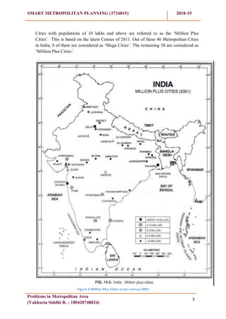
The State Govt. /Central Govt. Administration does not recognize the term ‗metropolitan
city‘. However the Central Government in 1994 fir teh first time categorized 6 major
cities of India as ‗Mega Cities‘ defining these as cities having 50 lakhs or more
population. These were Mumbai. Kolkata, Delhi, Chennai, Bangalore and Hyderabad. It
was basically done to bring these under Mega City Funding Project.
However, going by Official or legalese, a City and its Agglomeration has been for the
first time recognized in the Indian Constitution. The Constitution Amendment Act,1992
(74th
CAA)(popularly known as „Nagarpalika Act‟) defines a metropolitan area as an
contiguous area (with a principal city as the main civic entity ) with 10 lakhs (1 Million)
or more and consisting of two or more Municipalities or Panchayats or other contiguous
area. Similarly, there is no distinction followed in respect of a metropolitan area and
metropolitan region. Both are synonymous. There is one difference though. In case of
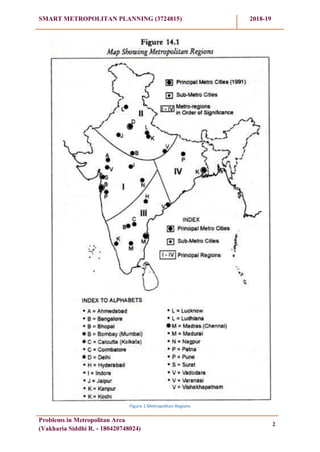
India, while there are 12 Metropolitan Regions as per 2011 Census, and there are
46 metropolitan cities in India, all of these have Development Authorities and 6 Urban
Agglomerations that need to be classified as Metropolitan areas
However, on the other hand, we have a total of 54 Urban Agglomerations ( and not all
of these have Development Authorities) per 2011 Census (that include the above-
mentioned 12 ‗Metropolitan Areas/regions‘) that are ‗metropolitan areas‘ going by the
definition in the Constitution of India and their status as metropolitan areas accordingly
changed by the respective States.
1.2 Urban Agglomeration (UA): [As per census 2011]
An urban agglomeration is a continuous urban spread constituting a town and its
adjoining outgrowths (OGs), or two or more physically contiguous towns together with
or without outgrowths of such towns. An Urban Agglomeration must consist of at least a
statutory town and its total population (i.e. all the constituents put together) should not be
less than 20,000 as per the 2001 Census. In varying local 2 | P a g e conditions, there
were similar other combinations which have been treated as urban agglomerations
satisfying the basic condition of contiguity. Examples: Greater Mumbai UA, Delhi UA,
etc.
6. SMART METROPOLITAN PLANNING (3724815) 2018-19
Problems in Metropolitan Area
(Vakharia Siddhi R. - 180420748024)
2
Figure 1 Metropolitan Regions
7. SMART METROPOLITAN PLANNING (3724815) 2018-19
Problems in Metropolitan Area
(Vakharia Siddhi R. - 180420748024)
3
Cities with populations of 10 lakhs and above are referred to as the ‗Million Plus
Cities‘. This is based on the latest Census of 2011. Out of these 46 Metropolitan Cities
in India, 8 of them are considered as ‗Mega Cities‘. The remaining 38 are considered as
‗Million Plus Cities‘.
Figure 2 Million Plus Cities as per cencus 2001
8. SMART METROPOLITAN PLANNING (3724815) 2018-19
Problems in Metropolitan Area
(Vakharia Siddhi R. - 180420748024)
4
Table 1.1 List of top 10 Metropolitan/Urban Agglomeration Areas:
(As per census 2011)
Rank Metropolitan Area Population Area (in km2
)
1
Central Capital Region
(Delhi, Haryana, Uttar Pradesh)
Only Delhi
27,735,000
16,349,831
2,163
2
Mumbai Metropolitan Region 18,384,000 4,354
3
Kolkata Metropolitan Region 14,720,000 1,851
4
Chennai Metropolitan Area 8,653,521 1,189
5
Bangalore Metropolitan Region 8,520,167 8,005
6
Hyderabad Metropolitan Region 7,674,000 7,257
7
Ahmedabad Metropolitan Area 6,361,084 8,107
8
Pune Metropolitan Area 7,276,000 7,256
9
Surat Metropolitan Area 4,691,246 4,418
10
Kanpur Metropolitan Area 2,920,496 8,231
These first 8 are known as „Mega Metropolitan Ciries‟
9. SMART METROPOLITAN PLANNING (3724815) 2018-19
Problems in Metropolitan Area
(Vakharia Siddhi R. - 180420748024)
5
2. Characteristics of Metropolitan Area
The characteristics of the Metropolitan of several aspects such as the amount of
population, economic activities, mobility, activities of the population, and the structure
of the region.
2.1 The amount of the total population
The magnitude of population becomes a major consideration in determining the aspects
of the definition of a metropolitan. However, some urban experts set different limits for
the determination of the minimum number of metropolitan area population.
2.2 Economic activity
In the metropolitan area occurs agglomeration residential areas and jobs. That is, the
metropolitan area is an urban area with a specializing in social and economic activities
function. The economic specialization is the industrial and services sectors. Industrial
activities and services is the dominant sector in the growing metropolitan region.
Economic activities that take place in the metropolitan area is heterogeneous and has a
role as a central / centre of economic activities on a regional scale, both within the
province or state and national scope. Metropolitan supposedly able to play a role and
function in accordance with its share in national economic development. On the other
hand, the role of the national economy must be balanced with the metropolitan economy
comparable level and is able to also write a decent life for the citizens of the metropolitan
community itself.
Metropolitan should be able to create jobs and income level sufficient for people to be
able to survive and even enjoy life in the metropolitan environment. The income levels
are generally far exceeds the metropolitan cities and other areas as well as rural, and the
main attraction for the current metropolitan population who are looking for work and a
decent life.
Surely there must be taken into account that the level of public spending in general
metropolitan also much higher than the city and other areas.
2.3 Mobility of people‟s activities
One characteristic of the metropolitan area is shown in the form of ease of mobility by
Angotti (1993) seen in 3 forms (Winarso et al, 2006), namely:
a. Occupational mobility (mobility Employment)
b. Housing Mobility (Residential Mobility)
c. Mobility trip (Trip Mobility)
10. SMART METROPOLITAN PLANNING (3724815) 2018-19
Problems in Metropolitan Area
(Vakharia Siddhi R. - 180420748024)
6
2.4 Structure Regions
Broadly speaking there are two kinds of physical form metropolis that shapes the
metropolis spread (dispersed) and the shape of the metropolis centred (concentrated). To
spread the metropolis consists of the metropolis spreads and galactic metropolis. As for
the centralized metropolis comprises centred metropolis, metropolitan and metropolitan
ring star.
11. SMART METROPOLITAN PLANNING (3724815) 2018-19
Problems in Metropolitan Area
(Vakharia Siddhi R. - 180420748024)
7
3. Major Problems of Metropolitan Cities in India
Although India is one of the less urbanized countries of the world with only 27.78 per
cent of her population living in urban agglomerations/towns, this country is facing a
serious crisis of urban growth at the present time. Whereas urbanization has been an
instrument of economic, social and political progress, it has led to serious socio-
economic problems.
The sheer magnitude of the urban population, haphazard and unplanned growth of urban
areas, and a desperate lack of infrastructure are the main causes of such a situation. The
rapid growth of urban population both natural and through migration, has put heavy
pressure on public utilities like housing, sanitation, transport, water, electricity, health,
education and so on.
Some of the major problems in Metropolitan Areas are;
1. Urban Sprawl
2. Overcrowding
3. Housing
4. Unemployment
5. Slums and Squatter Settlements
6. Transport
7. Water
8. Sewerage Problems
9. Trash Disposal
10. Urban Crimes
11. Problem of Urban Pollution
3.1 Urban Sprawl:
Urban sprawl or real expansion of the cities, both in population and geographical area, of
rapidly growing cities is the root cause of urban problems. In most cities the economic
base is incapable of dealing with the problems created by their excessive size. Massive
immigration from rural areas as well as from small towns into big has taken place almost
consistently; thereby adding to the size of cities.
The first large flow of migration from rural to urban areas was during the ―depression‖ of
late 1930s when people migrated in search of jobs. Later, during the decade 1941-51,
another a million persons moved to urban places in response to wartime industrialisation
and partition of the country in 1947.
During 1991-2001, well over 20 million people migrated to cities. The greatest pressure
of the immigrating population has been felt in the central districts of the city (the old city)
where the immigrants flock to their relatives and friends before they search for housing.
Population densities beyond the ―old city‖ decline sharply.
Brush (1968) has referred to this situation in the central parts of the cities as ―urban
impulsion‖ which results from concentration of people in the centre of the city close to
12. SMART METROPOLITAN PLANNING (3724815) 2018-19
Problems in Metropolitan Area
(Vakharia Siddhi R. - 180420748024)
8
their work and shopping. Incidentally many of the fastest growing urban centres are large
cities.
This is due to the fact that such large cities act as magnets and attract large number of
immigrants by dint of their employment opportunities and modern way of life. Such
hyper urbanisation leads to projected cities sizes of which defy imagination. Delhi,
Mumbai, Kolkata, Chennai, Bangalore, etc. are examples of urban sprawl due to large
scale migration of people from the surrounding areas.
In several big cities wealthy people are constantly moving from the crowded centres of
the cities to the more pleasant suburbs where they can build larger houses and enjoy the
space and privacy of a garden around the house.
3.2Overcrowding
Overcrowding is a situation in which too many people live in too little space.
Overcrowding is a logical consequence of over-population in urban areas. It is naturally
expected that cities having a large size of population squeezed in a small space must
suffer from overcrowding. This is well exhibited by almost all the metropolitan cities of
India.
For example, Mumbai has one-sixth of an acre open space per thousand populations
though four acre is suggested standard by the Master Plan of Greater Mumbai.
Metropolitan cities of India are overcrowded both in ‗absolute‘ and ‗relative‘ terms.
Absolute in the sense that these cities have a real high density of population; relative in
the sense that even if the densities are not very high the problem of providing services
and other facilities to the city dwellers makes it so.
Delhi has a population density of 9,340 persons per sq km (Census 2001) which is the
highest in India. This is the overall population density for the Union territory of Delhi.
Population density in central part of Delhi could be much higher. This leads to
tremendous pressure on infrastructural facilities like housing, electricity, water, transport,
employment, etc. Efforts to decongest Delhi by developing ring towns have not met with
the required success.
Figure 3 Overcrowing on Rail network
13. SMART METROPOLITAN PLANNING (3724815) 2018-19
Problems in Metropolitan Area
(Vakharia Siddhi R. - 180420748024)
9
3.3Housing
Overcrowding leads to a chronic problem of shortage of houses in urban areas. This
problem is specifically more acute in those urban areas where there is large influx of
unemployed or underemployed immigrants who have no place to live in when they enter
cities/towns from the surrounding areas.
An Indian Sample Survey in 1959 indicated that 44 per cent of urban households
occupied one room or less. In metro cities the proportion of families occupying one room
or less was as high as 67 per cent. 39% of all married couples in India (about 86 million)
do not have an independent room to themselves. As many as 35% (18.9 million) urban
families live in one-room houses.
For about a third of urban Indian families, a house does not include a kitchen, a
bathroom, a toilet—and in many cases there is no power and water supply. Only 79 per
cent (42.6 million) urban household live in permanent (pucca) houses. 67 per cent (36
million) of the urban houses are owned by the households while 29 per cent (15 million)
are rented.
3.4 Unemployment
The problem of unemployment is no less serious than the problem of housing mentioned
above. Urban unemployment in India is estimated at 15 to 25 per cent of the labour force.
This percentage is even higher among the educated people.
It is estimated that about half of all educated urban unemployed are concentrated in four
metropolitan cities (Delhi, Mumbai, Kolkata, and Chennai). Furthermore, although urban
incomes are higher than the rural incomes, they are appallingly low in view of high cost
of living in urban areas.One of the major causes of urban unemployment is the large scale
migration of people from rural to urban areas.
But the growth of economic opportunities fails to keep pace with the quantum of
immigration. The limited capacity of metropolitan areas could not create enough
employment opportunities and absorb the rapid growth of the urban labour force. Efforts
made by the central and the state governments to create employment opportunities in
rural areas and to check the large scale rural-urban migration have not met with much
success.
14. SMART METROPOLITAN PLANNING (3724815) 2018-19
Problems in Metropolitan Area
(Vakharia Siddhi R. - 180420748024)
10
3.5 Slums and Squatter Settlements
The natural sequel of unchecked, unplanned and haphazard growth of urban areas is the
growth and spread of slums and squatter settlements which present a striking feature in the
ecological structure of Indian cities, especially of metropolitan centers.
In spite of several efforts by the Central and State Governments to contain the number of
slum dwellers, their growth has been increasing sharply exerting tremendous pressure on the
existing civic amenities and social infrastructure. In India Slums have been defined under
section 3 of Slum Areas (Improvement and Clearance) Act 1956
Socially, slums tend to be isolated from the rest of the urban society and exhibit pathological
social symptoms (drug abuse, alcoholism, crime, vandalism and other deviant behavior). The
lack of integration of slum inhabitants into urban life reflects both, the lack of ability and
cultural barriers.
Slums are known by different names in different cities. They are called bustees in Kolkata,
jhuggi- jhoparies in Delhi, Jhoparpattis or Chawl in Mumbai and Cheri in Chennai.
A list of 26 million plus cities reporting slum population in 2001 (Municipal Corporation). As
expected, the largest concentration of slum population is found in four metropolitan cities of
Greater Mumbai, Delhi Municipal Corporation (Urban), Kolkata and Chennai. So far as
percentage of slum population to total population of the cities (municipal) is concerned,
Grater Mumbai with 48.88 per cent of its population consisting of slum dwellers is the worst
suffer. Dharavi slum in Central Mumbai is the largest slum of Asia.
The largest slum population of 10.6 million has been reported from Maharashtra; followed by
Andhra Pradesh (5.1 million), Uttar Pradesh (4.1 million), West Bengal (3.8 million), Tamil
Nadu (2.5 million), Madhya Pradesh (2.4 million) and Delhi (2.0 million).
Figure 4 Kolkata Slum (Source : TOI)
15. SMART METROPOLITAN PLANNING (3724815) 2018-19
Problems in Metropolitan Area
(Vakharia Siddhi R. - 180420748024)
11
3.6 Transport
Since most of the commercial activities of the towns are concentrated in the Central Business
District (C.B.D.), the centres are areas of greatest congestion. However, other parts of the
town are not free from traffic congestion.
The traffic scenario in almost all the Indian metro cities presents a pathetic picture with
Mumbai still having the best city transport system and Chennai, Ahmedabad and Pune being
reasonably well served by local transport system.
A study of traffic problem in Delhi will acquaint us to traffic scenario in the rest of urban
India. Already there are 44 lakh vehicles on Delhi roads (in 2004) which will almost double
by 2021 when the next Master Plan will be implemented. The road length, however, has not
increased proportionately.
The road length per vehicle was 3 km in 1971 which reduced to 2 km in 1981, 1.3 km in
1991, 0.68 km in 1998 and 0.23 km in 2004.Urban planners say that by 2021, going in a car
will take longer time than walking.
The guidelines for Delhi Master Plan 2021, allowing mixed land use, multi-storeyed
structures and regularisation of 24 industrial estates will add to the city‘s already congested
roads. Disturbing trends have also been indicated in the Status Report for Delhi, 2021
prepared by the Union Ministry of Environment and Forests. Planning Department of Delhi
Government also States that despite roads occupying 21 per cent of the total area of the city,
the increase of traffic on arterial roads is resulting in lower speeds, congestion, intersection
delays and higher pollution level during peak hours.
Figure 5 Transportation infrastructure of Delhi
16. SMART METROPOLITAN PLANNING (3724815) 2018-19
Problems in Metropolitan Area
(Vakharia Siddhi R. - 180420748024)
12
Figure 6 Traffic Congestion in Delhi (Source : TOI)
Similar conditions prevail in most of the Indian cities. In Kolkata, metro rail and Vivekanand
Setu were constructed to ease traffic flow. But traffic congestion in several old localities and
near Haora bridge is almost a daily routine. In Ahmedabad, the speed of vehicles comes
down to 5 km/hr on Gandhi Marg and several other roads due to congestion and
overcrowding
3.7 Water
The Zakaria Committee recommended the water requirement per head per day 204 litres for
cities with population between 5 lakh and 2 million and 272 litres for cities with population
more than 2 million. This amount of water is supposed to be used for drinking, kitchen,
bathing, cloth washing, floor and vehicle washing and gardening.
Sadly majority of the cities and towns do not get the recommended quantity of water. Gap in
demand and supply of water in four metro cities, viz., Mumbai, Kolkata, Delhi and Chennai
varies from 10 to 20 per cent. The condition is still worse in small cities and towns. To meet
the growing demand for water, many cities are trying to tap external sources of water supply.
Mumbai draws water from neighbouring areas and from sources located as far as 125 km in
the Western Ghats. Chennai uses water express trains to meets its growing demand for water.
Bangalore is located on the plateau and draws water from Cauvery river at a distance of 100
km. Water for Bangalore has to be lifted about 700 metres with help of lifting pumps.
17. SMART METROPOLITAN PLANNING (3724815) 2018-19
Problems in Metropolitan Area
(Vakharia Siddhi R. - 180420748024)
13
Hyderabad depends on Nagarjuna Sagar located 137 km away. Delhi meets large part of its
water requirements from Tajiwala in cities have old sewerage lines which are not looked after
properly. Often sewerage lines break down or they are overflowing.Haryana. Water is also
drawn from Ramganga as far as 180 km.
3.8 Sewerage Problem
According to latest estimates, only 35-40 per cent of the urban population has the privilege of
sewage system. Most of the
Most cities do not have proper arrangements for treating the sewerage waste and it is
drained into a nearly river (as in Delhi) or in sea (as in Mumbai, Kolkata and Chennai),
thereby polluting the water bodies.
In most Indian cities, water pipes run in close proximity to sewer lines. Any leakage leads to
contamination of water which results in the spread of several water borne diseases.
3.9 Trash Disposal
As Indian cities grow in number and size the problem of trash disposal is assuming alarming
proportions. Huge quantities of garbage produced by our cities pose a serious health problem.
Most cites do not have proper arrangements for garbage disposal and the existing landfills are
full to the brim. These landfills are hotbeds of disease and innumerable poisons leaking into
their surroundings. People who live near the rotting garbage and raw sewage fall easy victims
to several diseases like dysentery, malaria, plague, jaundice, diarrhoea, typhoid, etc.
Figure 7 From the Article "How India's Garden City becomes Garbage City: Bangalore
(Source : HindustanTimes)
18. SMART METROPOLITAN PLANNING (3724815) 2018-19
Problems in Metropolitan Area
(Vakharia Siddhi R. - 180420748024)
14
3.10 Urban Crime
The problem of urban crime is becoming more complicated in the present day world because
criminals often get protection from politicians, bureaucrats and elite class of the urban
society. Some of the criminals reach high political positions by using their money and muscle
power.
According to study made by Dutt and Venugopal (1983), violent urban crimes like rape,
murder, kidnapping, dacoity, robbery, etc. are more pronounced in the northern-central parts
of the country. Even the economic crimes (like theft, cheating, breach of trust, etc.) are
concentrated in the north- central region. Poverty related crimes are widespread with main
concentration in the cities of Delhi, Mumbai, Kolkata,Patna, Gaya and Munger. This may be
due to widespread poverty prevailing in this region.
However, the latest surveys show that Mumbai and Delhi figure in 35 cities that have high
crime rate. As much as 31.8% of citizens in Mumbai and 30.5% in Delhi have been victims
of crime. Sexual assault was higher in Mumbai (3.5 per cent) as compared to Delhi (1.7 per
cent). Both cities score poorly in corruption, with 22.9% in Mumbai being exposed to bribery
as compared to 21% in Delhi.
3.11 Urban Pollution
The share of urban areas in the total national economic income had been estimated at 60 per
cent and the per capita income was about three times higher than rural per capita income. But
this is not sufficient partly, due to high cost of living and partly, because of growing
economic disparity in urban areas. Rich are becoming richer and poor are becoming poorer.
Several steps have been initiated to meet the challenges posed by urban crisis but with little
or no success.
National Commission on Urbanization (NCU) has, in its policy proposal of 1988, stressed the
need for (a) the evolution of a spatial pattern of economic development and hierarchies of
human settlements, (b) an optimum distribution of population between rural and urban
settlements, and among towns and cities of various sizes, (c) distribution of economic
activities in small and medium-sized growth centres, (d) dispersal of economic activities
through the establishment of counter-magnets in the region, and (e) provision of minimum
levels of services in urban and rural areas.
The other major development programmes include (i) Urban Basic Services for the Poor
(UBSP) programme, (ii) the Environmental Improvement of Urban Slums (EIUS)
programme, (iii) the Integrated Development of Small and Medium Towns (IDSMT), (iv)
various housing and infrastructure financing schemes of Housing and Urban Development
Corporation (HUDCO), (v) the Mega Cities Project, and (vi) the Integrated Urban Poverty
Eradication Programme (IUPEP).
Almost all the major programmes of urban development suffer from the chronic disease of
resource crunch. Right from the beginning of the planning period, urban development has
been low on the development agenda with only 3-4 per cent of the total plan outlay being
allocated to the urban sector. The National Commission on Urbanization recommended in
1988 that at least 8 per cent of the Plan outlay should be dedicated to urban sector.
19. SMART METROPOLITAN PLANNING (3724815) 2018-19
Problems in Metropolitan Area
(Vakharia Siddhi R. - 180420748024)
15
4. Concluding Remark
India has already initiated to work major cities into smart cities which is appreciated
stop towards smart and sustainable development of cities.
But before making metropolitan cities and other major cities as a smart cities, Firstly
it would be focus on current problems which may pullback efforts to be the city smart
and try to dissolve it minimize its effect.
20. SMART METROPOLITAN PLANNING (3724815) 2018-19
Problems in Metropolitan Area
(Vakharia Siddhi R. - 180420748024)
16
REFERENCES
Census of India, 2001
Delhi Master Plan 2021
The city of Groningen as a justification of Metropolitan City
Transport Infrastucture of Delhui
Shekhar Mukherji (2006) Migration and Urban Decay; Asian Experiences, Rawat
Publication, Bangalore.
Muthukumaran and Ambujam,N.K. (2003) Wastewater Treatment, Department of
Economic and Social Affairs Population Division.
Pandey, S. (2006) Water Pollution and Health; Kathmandu University Medical
Journal 4, No.1, Issue 13,pp. 128-134
Times of India