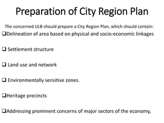
The document discusses satellite towns, which are smaller metropolitan areas located near but independent from larger cities. Satellite towns help decentralize populations and activities to reduce overcrowding in major cities. They have local governance and facilities, but rely on parent cities for some employment and education. The document outlines the need for satellite towns due to urban growth issues, and describes their characteristics, objectives in developing infrastructure, and the process of city and regional planning to integrate satellite towns with parent cities.
Town planning and architecture
HISTORY OF GARDEN CITY
FEATURES OF GARDENCITY
EXAMPLES O GARDEN CITY
REFERENCE -TOWN PLANNING AND ARCHITECTURE ,R S AGRAWAL
Town planning and architecture
HISTORY OF GARDEN CITY
FEATURES OF GARDENCITY
EXAMPLES O GARDEN CITY
REFERENCE -TOWN PLANNING AND ARCHITECTURE ,R S AGRAWAL
National Urban Housing and Habitat Policy-2007JIT KUMAR GUPTA
Presentation looks at the intent, content and scope of National Housing Policy 2007; Housing Finance Institutions, PMAY(U), in the context of housing for all in urban India
Local policies and strategies designed to deal with urban decline, decay or transformation are termed as urban renewal.
It is a comprehensive and integrated vision and action which leads to the resolution of urban problems and which seeks to bring about a lasting improvement in the economic, physical, social and environmental conditions of an area that has been subject to change’
With the decision and authority of a governing municipality, rearranging land use, function and ownership features of a socially, economically or structurally decayed part of a certain city .
such as slum zones or brown fields, for the purpose of obtaining a desired, well organized neighbourhood.
Growth pattern of towns Natural and Planned,
Types of zoning and importance,
various road networks(Grid iron pattern, shoe string development,
Surveys for data collection, physical survey, social survey, economic survey, civic survey,
Town aesthetics, landscape architecture,
Rehabilitation of slum and urban renewal,
DOXIADIS
HUMAN SETTLEMENT AND PLANING
CONSTANTINOS APOSTOLOU DOXIADIS
THEORY OF EKISTICS
Minor shells- Micro-settlements- Meso-settlements- Macro-settlements-Ekistics Logarithm Scale:-
BY EVOLUNITARY PHASE
BY FACTOR AND DISCIPLINE
CASE STUDY: ISLAMABAD
Master Plan
Comparison of Land cover
CONCEPT OF CITY PLANNING
ROAD NETWORK & HIERARCHY
ROAD NETWORK & TRANSPORT
HOUSES AND STREET PATTERN
GRID SYSTEM
CURRENT CHALLENGES FACED BY THE CITY
History of Town Planning_Building and Town PlanningA Makwana
The term town planning is used to indicate the arrangement of various components of a town in such a way that the town as such attains the significance of a living organism.
Growth pattern of towns Natural and Planned,
Types of zoning and importance,
various road networks(Grid iron pattern, shoe string development,
Surveys for data collection, physical survey, social survey, economic survey, civic survey,
Town aesthetics, landscape architecture,
Rehabilitation of slum and urban renewal,
Chennai the fourth largest metropolis in India. Chennai Metropolitan Area (CMA) extends over 1189 sq.km.and comprises of
Chennai Corporation,
16 Municipalities,
20 Town Panchayats and
214 villages covered in 10 Panchayats Unions
It encompasses the Chennai District (176 sq.km.), part of Thiruvallur District (637 sq.km.) and a part of Kancheepuram District (376 sq.km.).
A master plan or a development plan or a town plan may be
defined as a
general plan for the future layout of a city showing both the existing and
proposed streets or roads, open spaces, public buildings etc. A master
plan is prepared either for improvement of an old city or for a new
town to be developed on a virgin soil. A master plan is a blueprint for the
future. It is an comprehensive document, long-range in its view, that
is intended to guide development in the
township for the next 10 to 20 years.
Top 5 Deep Learning and AI Stories - October 6, 2017NVIDIA
Read this week's top 5 news updates in deep learning and AI: Gartner predicts top 10 strategic technology trends for 2018; Oracle adds GPU Accelerated Computing to Oracle Cloud Infrastructure; chemistry and physics Nobel Prizes are awarded to teams supported by GPUs; MIT uses deep learning to help guide decisions in ICU; and portfolio management firms are using AI to seek alpha.
This webinar was hosted on 20th August, 2015 from 4:00 – 5:00 pm IST and was presented by Vijay Anadkat, Senior Manager, EMBARQ India.
With a view to recast the urban landscape of India and make urban areas more livable and inclusive to drive economic growth in the country, the Government of India recently launched two ambitious projects - Smart City and Atal Mission for Rejuvenation and Urban Transportation (AMRUT). The purpose of AMRUT is to 1) ensure that every household has access to a tap with assured supply of water and a sewerage connection; 2) increase the amenity value of cities by developing greenery and well maintained open spaces; and 3) reduce pollution by switching to public transport or constructing facilities for non-motorized transport. The Mission is being implemented in 500 cities towns with a population of over 1 lakh.
This webinar discussed the current state of urbanization in India, the various propositions suggested by the government as a part of the AMRUT scheme and the feasibility of this project.
Webinar Recording - http://embarqindiahub.org/webinars/atal-mission-rejuvenation-and-urban-transportation-amrut-achievable-or-not
Spatial planning are often still differentiating strictly between urban and rural development.
This dichotomy and the resulting administrative boundaries do not reflect the realities of highly interconnected areas anymore.
The sheer magnitude of the urban population, haphazard and unplanned growth of urban areas, and a desperate lack of infrastructure are the main causes of socio economic problems related to metropolitan cities.
Where metropolitan-scale planning does occur, it's typically related to “hard policies” such as urban planning, public transport, and infrastructure, leaving “soft policies” such as education, health, and social services fragmented across jurisdictional boundaries.
Urban planning for smart cities - Smart tools for Smart CitiesVivek Pai
Smart Cities are the future of India and the GoI's Vision of a 100 Smart cities is slowly but surely coming into reality. The presenter discusses aspects of Smart cities and using the examples of some key projects and tools used by cities to add to the layers of smartness!
This is a presentation by Dada Robert in a Your Skill Boost masterclass organised by the Excellence Foundation for South Sudan (EFSS) on Saturday, the 25th and Sunday, the 26th of May 2024.
He discussed the concept of quality improvement, emphasizing its applicability to various aspects of life, including personal, project, and program improvements. He defined quality as doing the right thing at the right time in the right way to achieve the best possible results and discussed the concept of the "gap" between what we know and what we do, and how this gap represents the areas we need to improve. He explained the scientific approach to quality improvement, which involves systematic performance analysis, testing and learning, and implementing change ideas. He also highlighted the importance of client focus and a team approach to quality improvement.
Palestine last event orientationfvgnh .pptxRaedMohamed3
An EFL lesson about the current events in Palestine. It is intended to be for intermediate students who wish to increase their listening skills through a short lesson in power point.
Operation “Blue Star” is the only event in the history of Independent India where the state went into war with its own people. Even after about 40 years it is not clear if it was culmination of states anger over people of the region, a political game of power or start of dictatorial chapter in the democratic setup.
The people of Punjab felt alienated from main stream due to denial of their just demands during a long democratic struggle since independence. As it happen all over the word, it led to militant struggle with great loss of lives of military, police and civilian personnel. Killing of Indira Gandhi and massacre of innocent Sikhs in Delhi and other India cities was also associated with this movement.
Students, digital devices and success - Andreas Schleicher - 27 May 2024..pptxEduSkills OECD
Andreas Schleicher presents at the OECD webinar ‘Digital devices in schools: detrimental distraction or secret to success?’ on 27 May 2024. The presentation was based on findings from PISA 2022 results and the webinar helped launch the PISA in Focus ‘Managing screen time: How to protect and equip students against distraction’ https://www.oecd-ilibrary.org/education/managing-screen-time_7c225af4-en and the OECD Education Policy Perspective ‘Students, digital devices and success’ can be found here - https://oe.cd/il/5yV
Unit 8 - Information and Communication Technology (Paper I).pdfThiyagu K
This slides describes the basic concepts of ICT, basics of Email, Emerging Technology and Digital Initiatives in Education. This presentations aligns with the UGC Paper I syllabus.
Model Attribute Check Company Auto PropertyCeline George
In Odoo, the multi-company feature allows you to manage multiple companies within a single Odoo database instance. Each company can have its own configurations while still sharing common resources such as products, customers, and suppliers.
The Indian economy is classified into different sectors to simplify the analysis and understanding of economic activities. For Class 10, it's essential to grasp the sectors of the Indian economy, understand their characteristics, and recognize their importance. This guide will provide detailed notes on the Sectors of the Indian Economy Class 10, using specific long-tail keywords to enhance comprehension.
For more information, visit-www.vavaclasses.com
How to Make a Field invisible in Odoo 17Celine George
It is possible to hide or invisible some fields in odoo. Commonly using “invisible” attribute in the field definition to invisible the fields. This slide will show how to make a field invisible in odoo 17.
2. INTRODUCTION
What Are Satellite Townships?
A satellite town or satellite city is a concept in urban planning that
refers essentially to smaller metropolitan areas which are located
somewhat near to, but are mostly independent of, larger metropolitan
areas.
6. Development of Satellite Townships
Town or a city reach a certain limit of congestion and exhaustion
Land Shortage , Inadequate Transportation.
7. Charecteristics
predate the metropolis' suburban expansion
At least partially independent from that metropolis economically and
socially
Physically separated from the metropolis by rural territory or by a
major geographic barrier such as a large river; satellite cities should
have their own independent urbanized area, or equivalent
Have their own bedroom communities
Have a traditional downtown surrounded by traditional "inner city"
neighborhoods
May or may not be counted as part of the large metropolis' Combined
Statistical Area
8. Need For Satellite Town
Severe uncontrolled growth of
urban population
Problem in managing already
over strained cities
increase in the demand for
infrastructure facilities and
amenities
land shortage, housing shortfall,
inadequate transportation
9. Need For Satellite Town
Challenges in management of
essential infrastructure like
water supply
Sewerage
Drainage
solid waste disposal
10. Need For Satellite Town
Tremendous strain on the delivery of
services in major cities due to the
concentration of economic activities
and population
Need for decentralization of activities
so as to reduce the burden on these
cities.
11. FEATURES
Satellite townships have their own local government and corporate
life.
They have all the necessary amenities and facilities present within
their limits except for a few purposes like employment and sometimes
education, they have to depend on the main city i.e. the parent city.
Transportation means such as buses, trains etc all connect the various
satellite townships to the main city so that travelling to the main city
for work is not an issue. It is free to decide its economic, social and
cultural activities.
Satellite townships generally develop beyond the green belt of the
city.
12. FEATURES
setting up of industries is prohibited in Satellite townships. It is mainly
a residential area having only local shops, schools for children, etc.
Zoning regulations are not an issue in the development of satellite
townships.
These townships never become a rival to their parent city because
their size and development is restricted and controlled.
satellite townships are considered as a part of the market for some
goods and services that are produced in the parent city (some times)
13. Admissible Components
Central assistance will be admissible for the following components
Water supply and sanitation
Sewerage and solid waste management
Capacity building assistance
Sewerage and solid waste
Water supply
14. Inadmissible Components
Central assistance will not be admissible for the following components
Power
Telecom
Health
Education
Wage employment programmes
staff component
15. OBJECTIVES
To develop urban infrastructure facilities such as
DRAINAGE AND SOLID WASTE MANAGEMENT
TRANSPORTATIONSEWERAGE
16. OBJECTIVES
To adopt innovative public – private partnerships models for
development of satellite towns.
Earmarking 10-15% of housing sites for the urban poor
i.e,Economically Weaker Sections (EWS) / Low Income Group (LIG)
17. c. Reform of property tax with Geographical Information System (GIS)
and arrangements for its effective implementation so as to raise
collection efficiency to 85 per cent.
d. Levy of reasonable user charges, with the objective that full cost of
operation and maintenance is collected within some years.
18. Objectives
e. Internal earmarking of budgets
for basic services to the urban poor
f. Earmarking of housing sites for
the urban poor
g. Formulating bye laws which shall
incorporate provisions for disaster
management, rainwater harvesting,
reuse and recycle of waste water,
barrier free environment and
structural safety and shall also be in
strict compliance with the National
Building code
20. Process
City Development Plan for Satellite Town
Preparation of City Region Plan
Integration of Planning Process between the Mother City and
Satellite Towns.
Appraisal of City Development Plan
Detailed Project Report
Appraisal of Detailed Projects Reports
Sanction and monitoring of Projects under the Scheme
Monitoring and Evaluation
21. City Development Plan for Satellite Town
A City Development Plan (CDP) shall be prepared for the satellite town
by the ULB or some other agency designated for the purpose
Planning on concept of continuity, compactness and self –
containment
Each part of the township while being self-sufficient in itself should
form an integral part of the town as a whole having clear functional
linkages with the mother city and other urban centers
The planning of satellite town may adopt different kind of
development i.e. low-rise and low-density development/high rise
medium density or high-rise and high-density development depending
on the local and felt demand.
22. City Development Plan for
Satellite Town
The planning of the town shall address environmental
sustainability issues, green buildings and disaster mitigation
aspects
Incremental approach in providing for infrastructure /
facilities
have rational and judicious use of scarce resources both in
the form ofland and fiscal resources.
23. Preparation of City Region Plan
The concerned ULB should prepare a City Region Plan, which should contain:
Delineation of area based on physical and socio-economic linkages
Settlement structure
Land use and network
Environmentally sensitive zones.
Heritage precincts
Addressing prominent concerns of major sectors of the economy,
24. Integration of Planning Process between
the Mother City and Satellite Towns.
The planning process of the Mother town and the Satellite townships
shall be integrated through inclusion of suitable representation of the
Satellite Township in the Metropolitan Planning Committee of the
Mother Town.
25. Outcomes Of Satellite Township
Development
a. Amelioration of population pressure on metropolitan towns.
b. Improved financial management in urban local bodies.
c. Improvement in basic infrastructure and service delivery related to
water supply, sanitation and solid waste management.
d. Improved urban planning