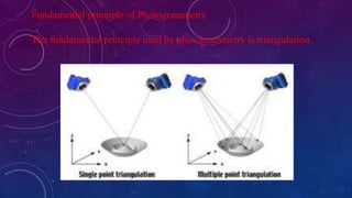
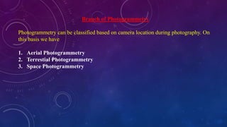
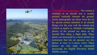
Photogrammetry is the science of making measurements from photographs. It involves deriving metric information about an object through measurements made on photographs. The fundamental principle of photogrammetry is triangulation. There are three main branches - aerial photogrammetry which uses cameras on aircraft, terrestrial photogrammetry which uses ground-based cameras, and space photogrammetry which uses cameras in space. Photogrammetry has various applications including topographic mapping, military intelligence gathering, soil classification, and assessing crop damage.
Aerial photogrammetry vs. terrestrial photogrammetryNI BT
The photogrammetry is broadly classified into two types as Aerial Photogrammetry and Terrestrial Photogrammetry. Aerial and Terrestrial photogrammetry are used for mapping and measurement related issues. Aerial is far range & terrestrial is close range photogrammetry
Aerial surveying technology is utilized in a wide range of fields throughout the world. These range from the creation of maps, to terrain analysis and research (rivers, soil erosion, coasts, etc.), urban planning, road planning (roads, rails, etc.), and vegetation research (forests, agriculture, lakes and marshland, etc.).
This presentation about photogrammetry survey, this presentation gives a complete detail of photogrammetry survey. Photogrammetry survey is a powerful technique used in various industries to obtain accurate measurements and three-dimensional (3D) data from photographs. It involves the process of extracting precise geometric information from images using specialized software, providing a cost-effective and efficient method for capturing and analysing spatial data.
Biological screening of herbal drugs: Introduction and Need for
Phyto-Pharmacological Screening, New Strategies for evaluating
Natural Products, In vitro evaluation techniques for Antioxidants, Antimicrobial and Anticancer drugs. In vivo evaluation techniques
for Anti-inflammatory, Antiulcer, Anticancer, Wound healing, Antidiabetic, Hepatoprotective, Cardio protective, Diuretics and
Antifertility, Toxicity studies as per OECD guidelines
2024.06.01 Introducing a competency framework for languag learning materials ...Sandy Millin
http://sandymillin.wordpress.com/iateflwebinar2024
Published classroom materials form the basis of syllabuses, drive teacher professional development, and have a potentially huge influence on learners, teachers and education systems. All teachers also create their own materials, whether a few sentences on a blackboard, a highly-structured fully-realised online course, or anything in between. Despite this, the knowledge and skills needed to create effective language learning materials are rarely part of teacher training, and are mostly learnt by trial and error.
Knowledge and skills frameworks, generally called competency frameworks, for ELT teachers, trainers and managers have existed for a few years now. However, until I created one for my MA dissertation, there wasn’t one drawing together what we need to know and do to be able to effectively produce language learning materials.
This webinar will introduce you to my framework, highlighting the key competencies I identified from my research. It will also show how anybody involved in language teaching (any language, not just English!), teacher training, managing schools or developing language learning materials can benefit from using the framework.
June 3, 2024 Anti-Semitism Letter Sent to MIT President Kornbluth and MIT Cor...Levi Shapiro
Letter from the Congress of the United States regarding Anti-Semitism sent June 3rd to MIT President Sally Kornbluth, MIT Corp Chair, Mark Gorenberg
Dear Dr. Kornbluth and Mr. Gorenberg,
The US House of Representatives is deeply concerned by ongoing and pervasive acts of antisemitic
harassment and intimidation at the Massachusetts Institute of Technology (MIT). Failing to act decisively to ensure a safe learning environment for all students would be a grave dereliction of your responsibilities as President of MIT and Chair of the MIT Corporation.
This Congress will not stand idly by and allow an environment hostile to Jewish students to persist. The House believes that your institution is in violation of Title VI of the Civil Rights Act, and the inability or
unwillingness to rectify this violation through action requires accountability.
Postsecondary education is a unique opportunity for students to learn and have their ideas and beliefs challenged. However, universities receiving hundreds of millions of federal funds annually have denied
students that opportunity and have been hijacked to become venues for the promotion of terrorism, antisemitic harassment and intimidation, unlawful encampments, and in some cases, assaults and riots.
The House of Representatives will not countenance the use of federal funds to indoctrinate students into hateful, antisemitic, anti-American supporters of terrorism. Investigations into campus antisemitism by the Committee on Education and the Workforce and the Committee on Ways and Means have been expanded into a Congress-wide probe across all relevant jurisdictions to address this national crisis. The undersigned Committees will conduct oversight into the use of federal funds at MIT and its learning environment under authorities granted to each Committee.
• The Committee on Education and the Workforce has been investigating your institution since December 7, 2023. The Committee has broad jurisdiction over postsecondary education, including its compliance with Title VI of the Civil Rights Act, campus safety concerns over disruptions to the learning environment, and the awarding of federal student aid under the Higher Education Act.
• The Committee on Oversight and Accountability is investigating the sources of funding and other support flowing to groups espousing pro-Hamas propaganda and engaged in antisemitic harassment and intimidation of students. The Committee on Oversight and Accountability is the principal oversight committee of the US House of Representatives and has broad authority to investigate “any matter” at “any time” under House Rule X.
• The Committee on Ways and Means has been investigating several universities since November 15, 2023, when the Committee held a hearing entitled From Ivory Towers to Dark Corners: Investigating the Nexus Between Antisemitism, Tax-Exempt Universities, and Terror Financing. The Committee followed the hearing with letters to those institutions on January 10, 202
Operation “Blue Star” is the only event in the history of Independent India where the state went into war with its own people. Even after about 40 years it is not clear if it was culmination of states anger over people of the region, a political game of power or start of dictatorial chapter in the democratic setup.
The people of Punjab felt alienated from main stream due to denial of their just demands during a long democratic struggle since independence. As it happen all over the word, it led to militant struggle with great loss of lives of military, police and civilian personnel. Killing of Indira Gandhi and massacre of innocent Sikhs in Delhi and other India cities was also associated with this movement.
Model Attribute Check Company Auto PropertyCeline George
In Odoo, the multi-company feature allows you to manage multiple companies within a single Odoo database instance. Each company can have its own configurations while still sharing common resources such as products, customers, and suppliers.
Macroeconomics- Movie Location
This will be used as part of your Personal Professional Portfolio once graded.
Objective:
Prepare a presentation or a paper using research, basic comparative analysis, data organization and application of economic information. You will make an informed assessment of an economic climate outside of the United States to accomplish an entertainment industry objective.
The French Revolution, which began in 1789, was a period of radical social and political upheaval in France. It marked the decline of absolute monarchies, the rise of secular and democratic republics, and the eventual rise of Napoleon Bonaparte. This revolutionary period is crucial in understanding the transition from feudalism to modernity in Europe.
For more information, visit-www.vavaclasses.com
2. What is Photogrammetry?
The classical definition of Photogrammetry is the process of deriving
metric information about an object through measurement made on the
photograph of the object. Photogrammetry is the science of making
measurements from photographs. Photogrammetry means the measuring
of features on a photograph.
This is concerned about metric or measurement aspect of the process. In
addition to this photo interpretation aspect is also involved while the
technology is used for mapping where feature collection is required.
4. The output of
photogrammetry is typically
a map, drawing,
measurement, or a 3D model
of some real-world object or
scene. Many of the maps we
use today are created with
photogrammetry and
photographs taken from
aircraft.
5. Fundamental principle of Photogrammetry
The fundamental principle used by photogrammetry is triangulation.
6. Branch of Photogrammetry
Photogrammetry can be classified based on camera location during photography. On
this basis we have
1. Aerial Photogrammetry
2. Terrestial Photogrammetry
3. Space Photogrammetry
7. 1. Aerial Photogrammetry: The camera is
mounted in an aircraft and is usually
pointed vertically towards the ground.
Aerial photographs are taken from the air
by special camera mounted in an aircraft
flying over the area with the camera axis
vertical or nearly so. Multiple overlapping
photos of the ground are taken as the
aircraft flies along a flight path. These
photos are processed in a stereo-plotter (an
instrument that lets an operator see two
photos at once in a stereo view). These
photos are also used in automated
processing for Digital Elevation Model
(DEM) creation.
8. 2. Terrestial Photogrammetry: is that
branch of photogrammetry where
photographs are taken from a fixed, and
usually known, position on or near the
ground and with the camera axis
horizontal or nearly so. The position and
orientation of the camera are often
measured directly at the time of
exposure. The instrument used for
exposing such photograph is called photo
theodolite.
9. 3. Space Photogrammetry: The space photogrammetry embraces all
aspects of extraterrestrial photography and subsequent measurement
wherein the camera may be fixed on earth, contained in an artificial
satellite, or positioned on the moon or a planet.
10. Types of Photogrammetry
There are two types of photogrammetry as follows:
1. Interpretative Photogrammetry.
2. Metric Photogrammetry.
A. Planimetric mapping.
B. Topographical mapping.
11. Interpretative Photogrammetry
Interpretative photogrammetry involves recognizing and identifying
objects and judging their significance through careful and systematic
analysis from photographic images.
Metric Photogrammetry
It consists of making precise measurements on photographs and other
information to determine relative locations of points.
12. Classification of Aerial Photographs
Aerial photographs which are normally used for mapping and photo
interpretation can be classified in to two main categories viz. vertical
and tilted.
Vertical Photograph:
An aerial photograph taken with the optical axis of the camera held
in a vertical or nearly vertical position is classified as vertical
photograph. When the geometry of a vertical photograph is
considered, the photograph is assumed to be taken with the optical
axis truly vertical.
13. Tilted Photograph:
In practice, the camera axis is nearly held vertical. But due to
unavoidable aircraft tilts the camera axis is unintentionally tilted from the
vertical. Then the resulting photograph is called tilted photograph.
If tilt of the camera axis from the plumb line is less than 3 degree the
photograph is called vertical. For tilt more than 3 degree, it is called tilted
photograph. Tilted photograph may again be classified in two categorizes
viz. low oblique and high oblique.
16. ii) Ground Control Points for stabilizing positional relationship between
photo and ground.
17. Advantages of Photogrammetry
• Cover areas quickly.
• Low costs.
• Easy to obtain/access information from air.
• Illustrates great detail.
18. Applications of Photogrammetry
1. To prepare planimetric topographical maps (Surveying/mapping).
2. To determine the space position of ground objects.
3. For acquisition of military intelligence (Military/artificial
intelligence).
4. To classify soil (Forestry/agriculture).
5. For the interpretation of geology (Geology/archaeology).
6. Assessment of crop damage due to floods or other natural
calamities.
7. To prepare a composite picture of ground.
8. To relocate existing property boundaries.
9. In the field of medicine.