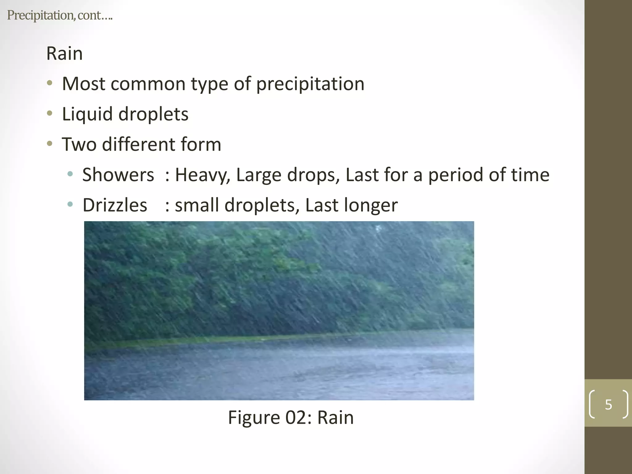
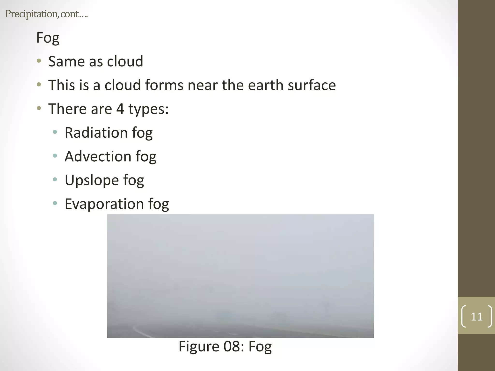
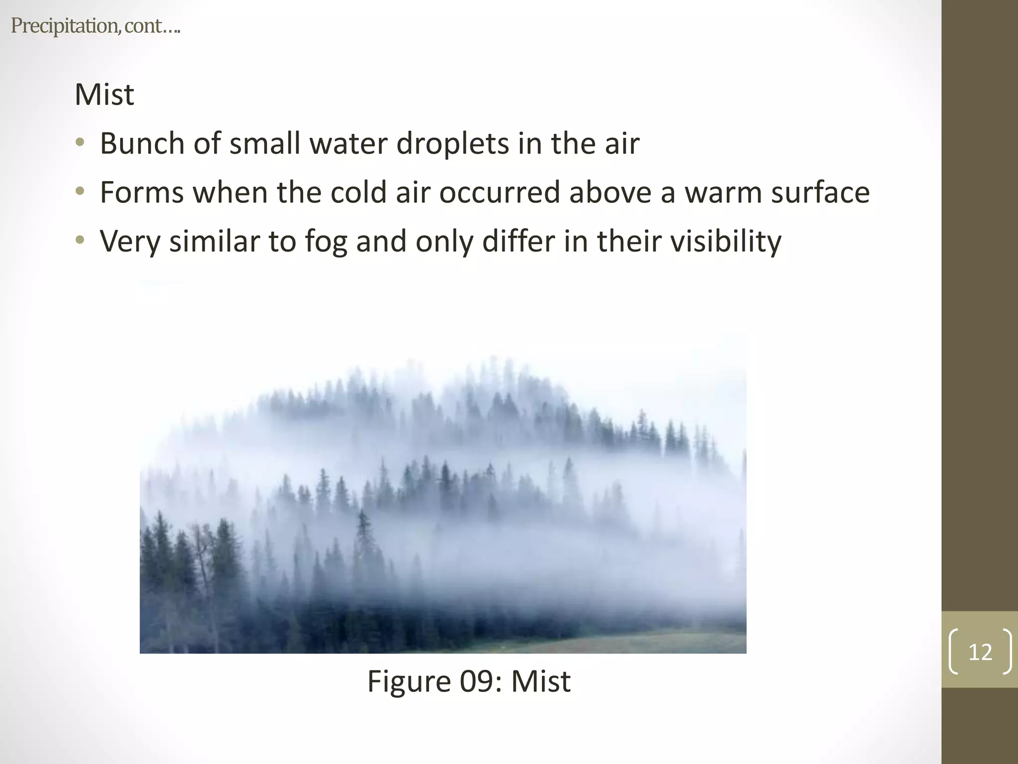
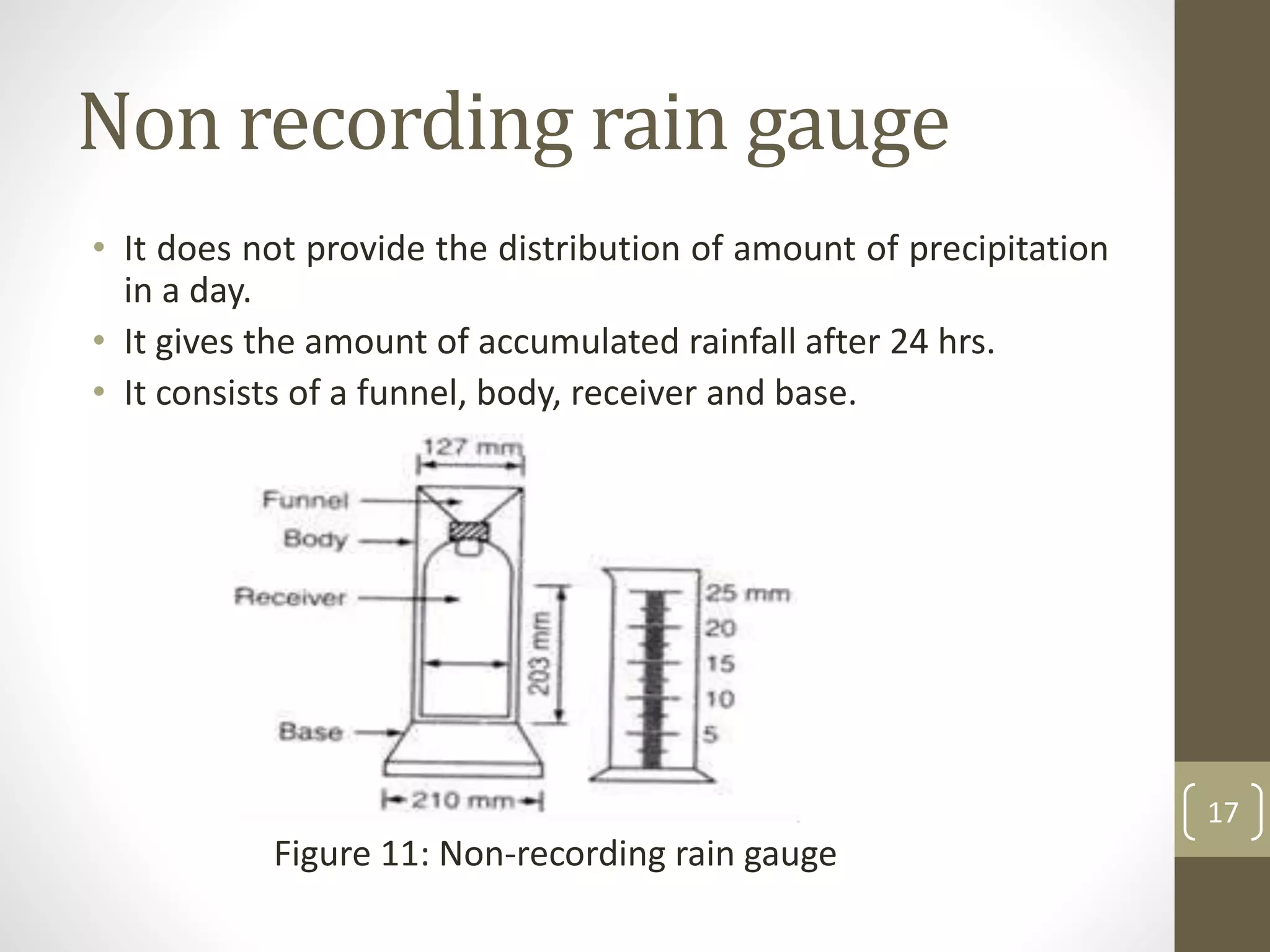
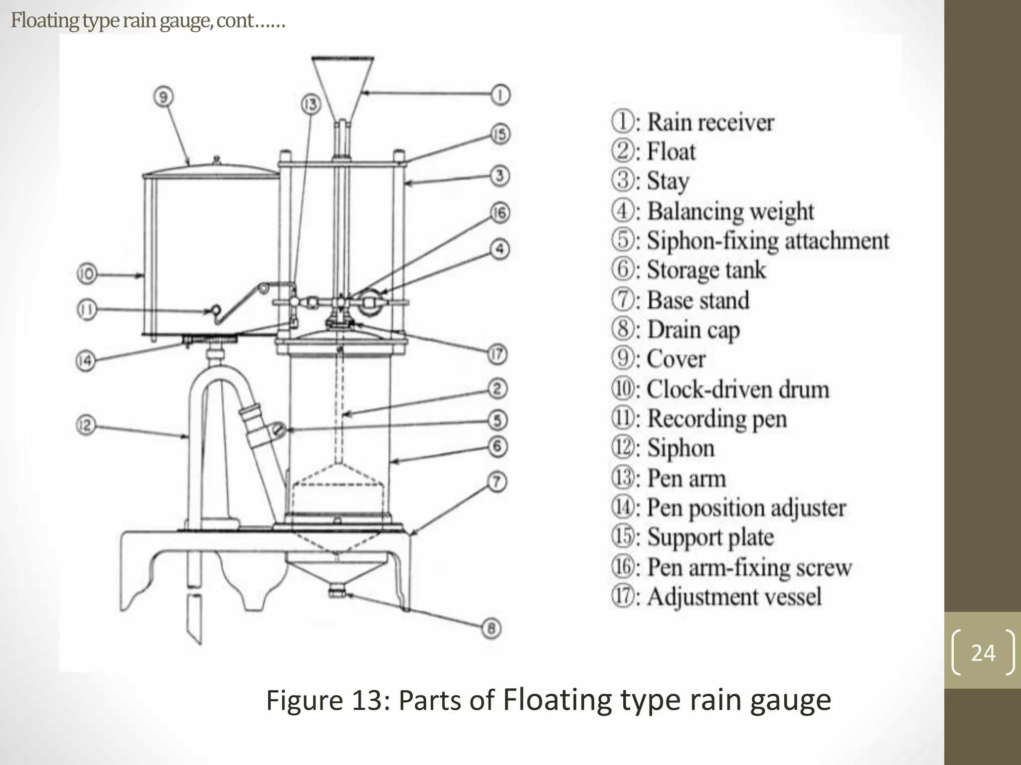
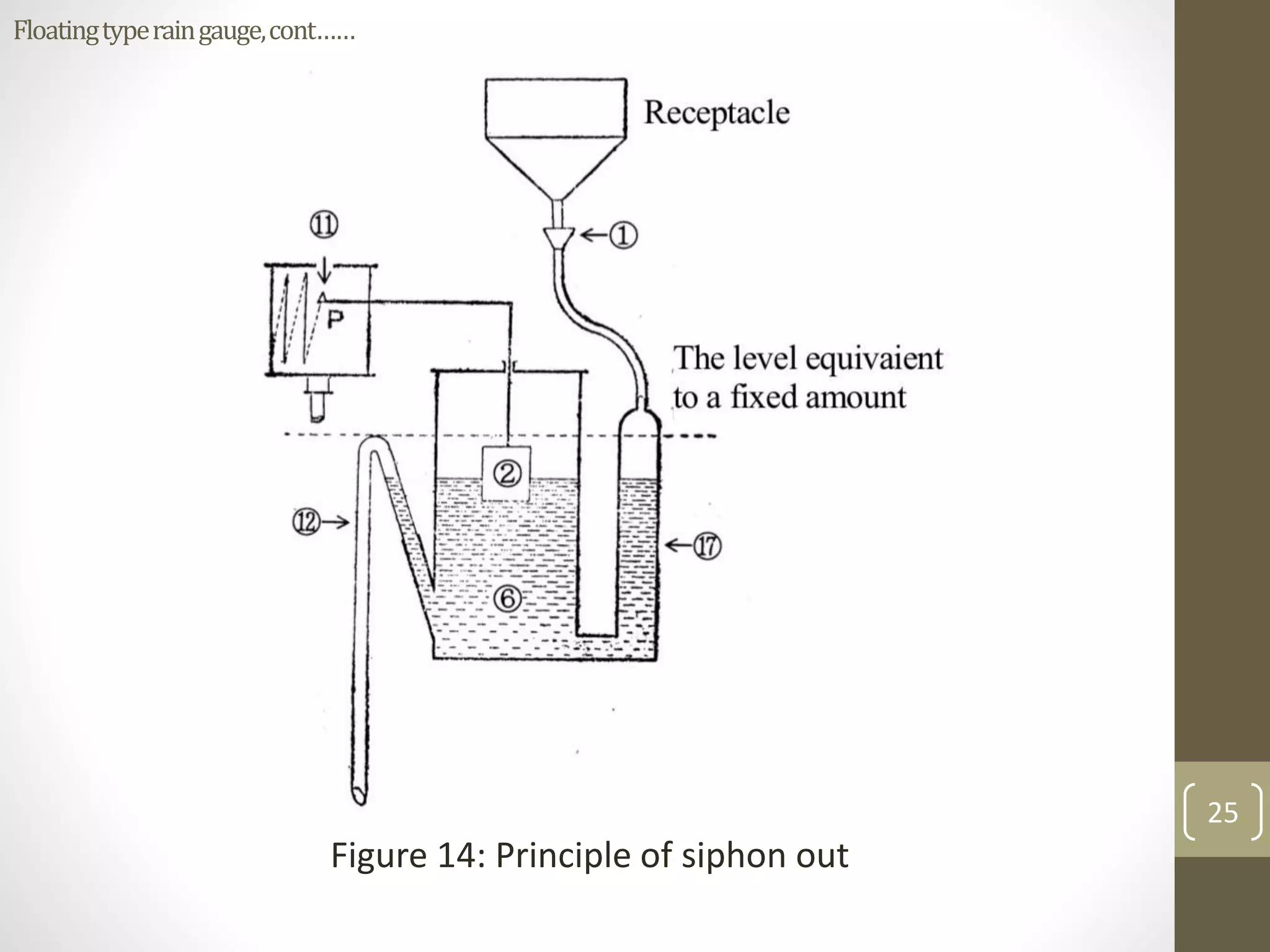
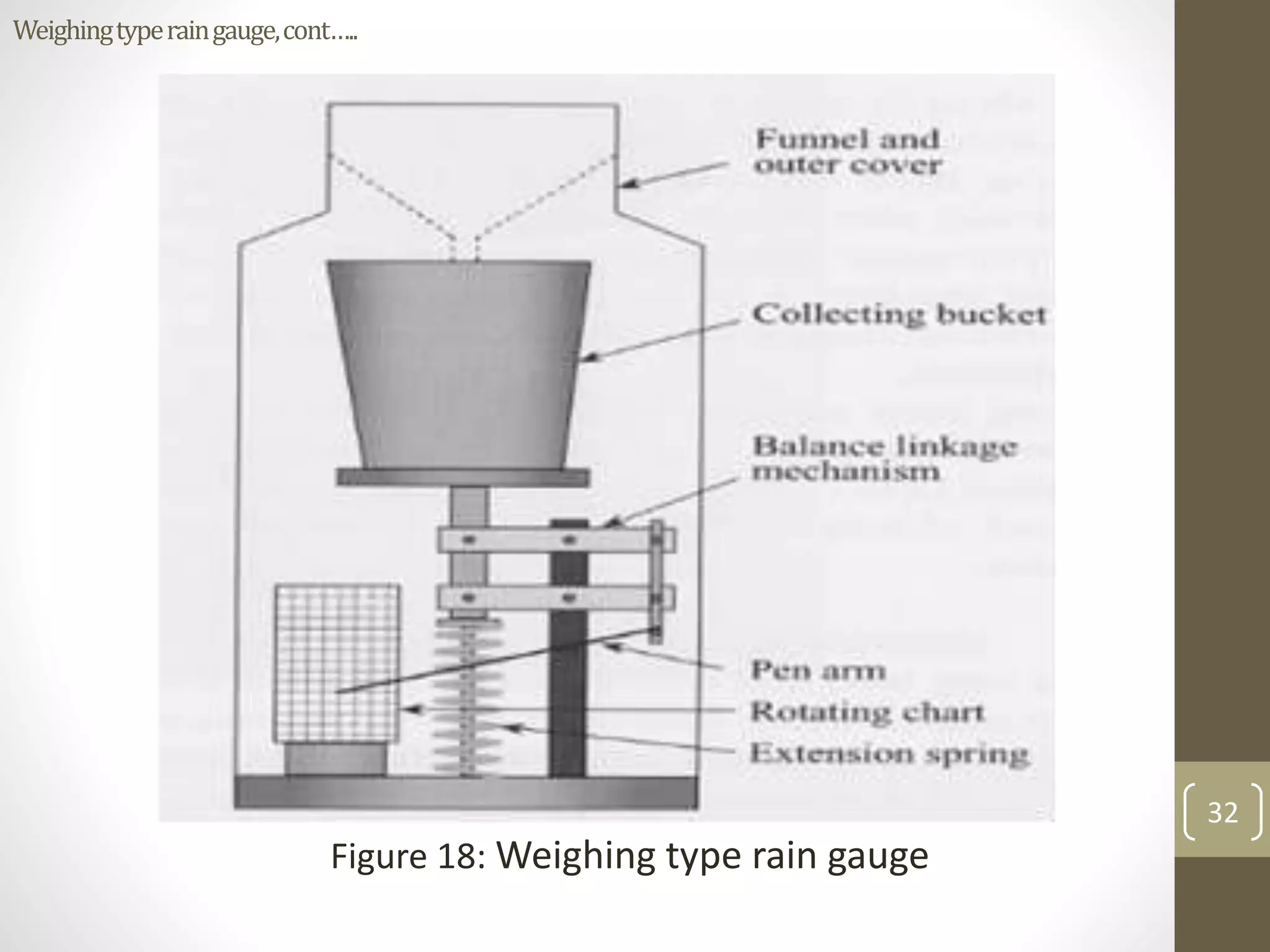
This presentation will provide the knowledge on measurement of evaporation by using class A evaporation pan. In addition it will give you the knowledge regarding pan coefficient and crop coefficient.
This document discusses evapotranspiration, which is the total amount of water lost as vapor from soil, plant surfaces, and water bodies. It defines evaporation as movement of water to the air from sources like soil and water bodies, while transpiration is movement of water within plants and subsequent loss of water vapor through leaf stomata. The document outlines different types of evapotranspiration and factors that affect the process, like plant/crop characteristics, soil properties, and geographical factors. It also describes methods to determine evapotranspiration rates, including indirect methods like water balance and energy balance approaches, and direct methods like using lysimeters to measure actual evapotranspiration.
This presentation covers direct and indirect methods of moisture measurement with clear descriptions of installation, principle, interpretation of readings, advantages and disadvantages of each method.
This document discusses various soil erosion control measures, including biological/agronomic practices like mulching, crop management, and soil management, as well as mechanical/engineering practices like terraces, bunds, vegetated waterways, and gully control. It provides details on the design of terraces, including the factors that influence terrace spacing, length, and cross-section. The key principles of erosion control are reducing rain drop impact, runoff volume and velocity, while increasing soil resistance to erosion. Agronomic practices are preferred where possible due to lower cost and easier integration with farming.
Irrigation engineering involves planning and designing water supply systems for crop irrigation. Key factors that necessitate irrigation include insufficient or uneven rainfall, requirements of perennial crops, and converting desert areas. Benefits of irrigation include increased crop yields, elimination of mixed cropping, prosperity of farmers, and sources of revenue from water taxes. Factors affecting the water requirements of crops include climate, soil type, irrigation method, and ground slope. Important terms include gross command area, culturable command area, crop rotation, base period, delta, and duty. The relationship between duty, base period, and delta is defined. Methods to improve duty involve efficient irrigation methods, reducing canal seepage and evaporation losses, and farmer training.
The Universal Soil Loss Equation (USLE) is a widely used method for estimating average annual soil loss. It was initially proposed in 1958 and modified to its current form in 1978. The USLE estimates soil loss as a function of rainfall erosivity, soil erodibility, slope length and steepness, crop management practices, and conservation support practices. It is used to predict soil loss, guide crop and management selections, and determine conservation needs. However, the USLE is empirical and only estimates average annual soil loss from sheet and rill erosion without considering sediment deposition.
This document describes the table method for estimating runoff. It involves using tables to determine peak runoff rates based on watershed characteristics like soil type, slope, and land cover. The tables are separated based on watershed shape - square, broad and short, or long and narrow. Users first determine the watershed characteristics score from Table 1, then find the peak discharge rate in the appropriate watershed shape table by matching the score and area. Two examples are provided to demonstrate calculating runoff rates using this method.
1) The document discusses evapotranspiration (ET), which is the combination of evaporation from soil and transpiration from plants. It also discusses consumptive use (CU), which is the total water used by plants for ET and metabolic activities.
2) ET can be potential, reference, or actual, depending on vegetation and water availability. It is affected by environmental, plant, geographical, and soil factors. CU depends on climate, crop type, soil properties, and management practices.
3) Both ET and CU are important concepts in irrigation and water resource management. Measuring ET and CU helps determine crop water requirements and design efficient irrigation systems.
There are three main types of recording rain gauges:
1) Tipping bucket gauges contain two buckets that tip when 0.25mm of rain is collected, actuating an electric circuit to mark rainfall on a revolving chart.
2) Weighing gauges use a spring-lever balance to move a pen across a chart as rainfall accumulates in a collecting tank.
3) Float gauges move a pen as rain fills a float chamber, with an overflow siphon chamber automatically draining excess water. The clockwork chart records rainfall over 24 hours.
This document discusses evapotranspiration estimation through lysimeters. It describes two main types of lysimeters - gravimetric lysimeters which measure evapotranspiration by weight changes, and volumetric lysimeters which measure by volume changes. Gravimetric lysimeters directly measure the actual evapotranspiration from a soil sample and crop on a daily basis. Volumetric lysimeters are used for standing water crops and measure the inflow and outflow of water volumes. Lysimeters provide accurate measurements of crop water requirements to determine irrigation scheduling.
The document discusses infiltration, which is the process by which water enters soil. It defines infiltration as the rate at which soil can absorb rainfall or irrigation, measured in mm/hr or inches/hr. An infiltrometer is used to measure infiltration rates. The infiltration capacity depends on factors like the soil type and moisture level, with dry soil having a higher capacity than moist soil. Infiltration is important for understanding groundwater recharge and runoff. Other factors like vegetation cover, land use, temperature, and water quality can also impact infiltration rates.
Measurement of rainfall is done using rain gauges, which collect precipitation and allow the amount to be measured. Non-recording rain gauges, like the commonly used Symons gauge in India, collect rainfall in a vessel that is read daily to determine the amount of precipitation. Recording rain gauges produce a continuous plot of rainfall over time through mechanisms like tipping buckets, weighing the collected water, or tracking a float level. Proper placement and regular maintenance of rain gauges is important for accurate measurement of precipitation.
Stream flow representing the runoff phase of the hydrologic cycle is the most important basic data for hydrologic studies. Runoff is generated by rainstorms. Its occurrence and quantity are dependent on the characteristics of the rainfall event, i.e. intensity, duration and distribution. This module highlights about runoff components of the hydrological cycle.
Uniformity coefficient of drip and sprinkler irrigation systemslingams
This document discusses uniformity coefficients for drip and sprinkler irrigation systems. It defines uniformity coefficient as a ratio that expresses the variation in particle sizes for a material. For sprinkler systems, Christiansen's uniformity coefficient is commonly used, where a value of 85% or more is considered satisfactory. The coefficient evaluates the uniformity of water application. For drip systems, Christiansen's formula only broadly indicates uniformity, as emitters differ from sprinkler nozzles. Emitter discharge variability depends on factors like operating pressure and temperature fluctuations. The document also introduces design emission uniformity, a metric proposed by Karmeli and Keller to evaluate drip system performance.
The document discusses infiltration, which is the process of rainwater entering the soil. Infiltrated water first meets any soil moisture deficit and then percolates vertically downward towards the groundwater table. The infiltration capacity of soil is the maximum rate at which it can absorb water and is denoted by f. Actual infiltration (fa) depends on whether the rainfall intensity (i) is greater than or less than the infiltration capacity. Infiltration is measured using infiltrometers and is affected by soil properties and antecedent moisture conditions.
Evaporation Pan meter , Pan Evaporimeter
Advantages and Disadvantages of Pan Evaporimeter.
Power point presentation for project description with summery.
Classification for pan evaporimeter.
Methods of Evaporation measurements
Special Methods of Sub Surface Drainage: Agricultural Draining EngineeringVenkata Sai Kari
This document discusses various methods of subsurface drainage including mole drainage, vertical drainage, bio drainage, and drainage design for heavy clay soils with multiple layers. Mole drainage involves creating unlined underground channels using a mole plough, and works well in stable clay soils but has a limited lifespan. Vertical drainage uses wells or multiple well points to lower the water table from depth. Bio drainage uses deep-rooted plants like eucalyptus to transpire large amounts of water from the subsurface. Designing drainage in layered clay soils requires considering perched water tables and installing drains in the more permeable layer. Computer modeling programs can aid in drainage system design by simulating subsurface flow.
This document discusses drip irrigation, including its components, design, advantages, and benefits for farmers. It begins with an introduction to irrigation and defines drip irrigation as a micro irrigation method that applies water slowly, drop by drop, directly to a crop's root zone. It then describes the key components of a drip irrigation system, such as pumps, filters, pipes, and emitters. The document outlines the design process, including collecting soil and crop data and determining water and equipment requirements. It notes the advantages of drip irrigation include water and cost savings compared to other methods. In conclusion, drip irrigation is an efficient irrigation system that uses less water to increase yields, benefiting small-scale farmers.
This document provides an overview of irrigation water management concepts including irrigation efficiency, scheduling, and conveyance efficiency. It includes definitions of key terms like irrigation efficiency (Ei), which is the ratio of water used for crop needs to total water diverted. Overall system efficiency considers storage, conveyance, and application losses. Conveyance efficiency (Ec) is the ratio of water delivered to fields to the amount diverted. It is affected by losses from evaporation, seepage, leakage and unwanted vegetation. The document also provides examples of calculating irrigation requirements, soil moisture content, and efficiencies for different irrigation systems and crops.
This document discusses types of rain gauges used to measure rainfall. It describes non-automatic/non-recording rain gauges like Symon's rain gauge which collect rainfall manually. It also describes automatic/recording rain gauges like weighing bucket, tipping bucket, and float type gauges that record rainfall continuously without manual measurement. Recording gauges provide rainfall intensity over time through a pen on a rotating drum, while non-recording gauges only give total rainfall. Recording gauges do not require an attendant but are more expensive and prone to mechanical faults.
Watershed management aims to enable sustainable production and minimize hazards to natural resources like soil and water. A watershed is a geographical area that drains to a common water body. Key components of watershed management programs include soil and water conservation measures, water harvesting, and crop management and alternate land use systems suited to land capability. The overall objectives are improved livelihoods through increased incomes while protecting watershed resources.
Evaporation, transpiration and evapotranspirationStudent
1) Evaporation, transpiration, and evapotranspiration are key processes in the hydrological cycle. Evaporation is the process by which liquid water changes to a gas, transpiration is the process by which plants release water vapor into the air, and evapotranspiration accounts for both soil evaporation and plant transpiration.
2) There are several methods for measuring evapotranspiration rates, including lysimeters, water balance methods, eddy covariance, and remote sensing techniques using satellites.
3) Potential evapotranspiration refers to the theoretical maximum amount of water that could be evaporated or transpired, while actual or effective evapotranspiration depends on available water supply from the soil and
This document discusses factors that affect evapotranspiration, which is the combination of evaporation from soil and transpiration from plants. It identifies weather parameters like radiation, temperature, humidity and wind speed as well as crop characteristics and development stage. Management practices and environmental conditions such as soil salinity, fertility, and water content can also impact evapotranspiration rates. Additional considerations include cultivation practices, irrigation methods, windbreaks, mulching, and anti-transpirants which can alter microclimates and crop characteristics to influence evapotranspiration.
IN this presentation cover Erosivity and erodibilty
Different methods to calculate soil loss.
Er. Gurpreet Singh
M.tech from PAU, Ludhiana
Assistant Prof.
Khalsa college.
This document discusses precipitation and methods of measuring precipitation. It defines precipitation as moisture falling from the atmosphere in any form. The key forms of precipitation are liquid (rain, drizzle) and frozen (snow, hail, sleet). Precipitation is measured using various devices like rain gauges and satellites. Rain gauges include non-recording and recording types like tipping bucket gauges. Methods to calculate average precipitation over an area include arithmetic averages, Thiessen polygons, and isohyetal mapping. Factors influencing precipitation amounts are also examined.
Topic1 >Illustration of various types of rain-gauges.,,2> Advantaged and dis...faizanNoor8
in this presentation you will know about following head line point.
1>Illustration of various types of rain-gauges.
2>Advantaged and disadvantages of various types of gauges.
Introduction, hydrologic cycle, climate and water m1Bibhabasu Mohanty
Introduction, Hydrologic cycle, Climate and water availability, Water balances,
Precipitation: Forms, Classification, Variability, Measurement, Data analysis, Evaporation and its measurement, Evapotranspiration and its measurement, Penman Monteith method. Infiltration: Factors affection infiltration, Horton’s equation and Green Ampt method.
Introduction to Hydrology, Stream GaugingAmol Inamdar
Introduction to Hydrology, Types of Rain gauges, Factors affecting evaporation and infiltration, Stream gauging, Mass curve, Hyetograph, DAD Curve, Horton's Method, Infiltrometers, fi-index, W-index, Methods of measurement of Discharge of Stream, Area-Velocity Method, Moving Boat Method, Salt concentration method, ADCP, Current meter, River staging
The hydrological cycle describes the continuous movement of water on, above, and below the surface of the Earth. Water exists in three forms on Earth - liquid (oceans, lakes, rivers), solid (ice caps, glaciers, snow), and gas (water vapor in the air). The sun drives the hydrological cycle by evaporating water from the surface into the air as vapor, which rises and cools to form clouds. Precipitation occurs when clouds become heavy with water and it falls as rain or snow. Water also returns to the air through evaporation from soil and transpiration from plants. Water running on land and underground replenishes rivers, lakes, and groundwater in a constant cycle powered by energy from
This document provides an introduction to engineering hydrology. It discusses key hydrological concepts like the hydrological cycle, precipitation types and measurement, and mechanisms of precipitation. Engineering hydrology deals with water resource estimation, processes like precipitation and runoff, and problems like floods and droughts. Precipitation is measured using non-recording rain gauges and recording rain gauges like tipping buckets, weighing buckets, and float gauges. Site selection for rain gauges and data preparation are also outlined.
There are two main types of rain gauges - non-recording and recording. Non-recording gauges simply measure the total rainfall over a time period, such as the commonly used Symon's rain gauge with a funnel and receiving vessel. Recording gauges provide an automatic record of rainfall, allowing measurement of intensity. Three types of recording gauges are the weighing bucket type, which measures weight changes on a chart; the tipping bucket type, which tips to record 0.25mm of rain; and the floating type, which uses a float and syphon to record water levels on a chart. Recording gauges provide more detailed data but have higher costs and can experience mechanical or electrical faults.
The document discusses various methods for analyzing rainfall and runoff data in hydrology. It describes hyetographs and mass curves as ways to present rainfall intensity over time. Point rainfall data represents daily/weekly rainfall values in bar diagrams. Intensity-duration-frequency curves relate rainfall intensity, duration and probability. Depth-area-duration curves show the relationship between rainfall depth, area and duration. Infiltration and factors affecting it are also discussed. Common methods for measuring infiltration include single tube and double tube infiltrometers. Empirical equations, tables and regression models are presented for estimating runoff from rainfall-runoff data.
This document discusses different types of rain gauges used to measure precipitation. There are two main types: non-recording gauges that provide total rainfall over a period, like the commonly used Symon's gauge; and recording gauges that provide a continuous rainfall record. Recording gauges include the weighing bucket type, which tracks accumulated rainfall on a chart via a weighted bucket, the tipping bucket type, which tips to mark rainfall intervals electronically, and the floating type, which uses a float and syphon to record rainfall levels over time. Recording gauges provide more detailed rainfall data without needing an attendant but have higher costs.
This document provides an overview of hydrology and related concepts. It defines hydrology as the study of water on Earth, describes the hydrologic cycle of evaporation, precipitation, and runoff, and identifies the major sources and components of water. Measurement tools like rain gauges and types of precipitation such as orographic, convective, and cyclonic are explained. Factors affecting rainfall and important hydrologic terminology are also defined.
Precipitation occurs when atmospheric moisture condenses and falls to the earth's surface. The main forms of precipitation are rain, snow, hail, drizzle and dew. Precipitation is measured using rain gauges and satellite imagery. There are various types of precipitation depending on what causes the air to lift and cool, such as convection, orographic lifting, and cyclonic storms. Data from rain gauges needs to be quality controlled to ensure accuracy by checking for consistency using methods like double mass curves and adjusting records when inconsistencies are found.
chapter 2.ppt ,hydrological study of ethi0mulugeta48
hydrology ,A programme of groundwater investigations is to obtain information on the resource through systematic collection, synthesis, interpretation and compilation of data.
It seeks information on its occurrence, movement, storage, recharge, discharge, quality & quantity.
It includes the study of its geological, environmental, as well as the hydrologic and hydraulic aspects of its flow system.
Geologic Methods
A geologic investigation begins with the collection, analysis, and hydrogeologic interpretation of existing topographic map, aerial photographs, geologic maps and logs, and other pertinent records.
This should be supplemented, when possible, by geologic field reconnaissance and by evaluation of available hydrologic data on: stream flow and springs; well yields; groundwater recharge & levels; and water quality
Rainfall is measured using a rain gauge, which is usually placed in an open field, partially buried in the ground and 30 cm above the ground. Rainfall is measured in millimeters and recorded from the rain gauge. Rain is a type of precipitation that occurs when water vapor in the air condenses into water droplets.
This document discusses the subject of engineering hydrology. It begins with an overview of the hydrological cycle and defines a catchment area. Next, it describes precipitation, including its types and measurement. Methods for estimating missing rainfall data from nearby stations are then outlined, including simple arithmetic averaging, normal ratio, modified normal ratio, inverse distance, and linear programming methods. Recording and non-recording rain gauges are also defined.
Rainfall can be measured in several ways:
- Rain gauges measure the total depth of rainfall over a given time period in millimeters.
- Disdrometers measure the size and velocity of individual rain drops to gather data on drop size distribution.
- Weather radars are used to create rainfall maps over large areas by computing rainfall amounts at multiple locations for time periods like 5 minutes or 1 hour.
This document discusses precipitation, including its various forms, the requirements and mechanisms for its formation, and methods for measuring and estimating precipitation. It defines precipitation as water falling from the atmosphere to Earth's surface in solid or liquid form. The main forms are rain, snow, sleet, hail, and dew. Precipitation forms through the lifting of air masses, temperature gradients, water vapor saturation, and the presence of aerosol particles for condensation. Measurement methods include non-recording and recording rain gauges. Estimation of missing data uses surrounding station averages or normal rainfall ratios.
Estimating sewage discharge and peak drainage dischargeAnkit Gola
This document discusses methods for estimating sewage discharge and drainage/runoff. It explains that sewage is estimated based on water supplied plus additions from other sources and minus subtractions. Drainage is estimated using factors like rainfall intensity, duration, soil moisture, and catchment area. The Rational Method and empirical formulas like Dickens are presented to calculate peak runoff rates based on these factors and the imperviousness of surfaces. An example application of the Rational Method to a 36 hectare district with maximum 5 cm/hr rainfall is also provided.
You can gain ideas on toxico-kinetics from this presentation. Different aspects regarding bio-concentration and bioaccumulation. In addition, demerits of different toxic chemicals from food industries are discussed with examples.
It will be an appropriate source for you to understand about the food toxicology. Further, the impacts of genetically modified are discussed in detail. the effects of toxicity in human and other living organisms are included in this document with examples.
This presentation will provide you knowledge on physical transport of chemicals. Overall cycling of pollutants are well discussed with adequate details.
This document discusses various aspects of irrigation including the importance of water for agriculture, different irrigation methods, and microirrigation systems. It describes that irrigation is the artificial application of water to assist crop growth. Several irrigation methods are discussed in detail, including surface irrigation methods like flooding, border strip, basin, check, and furrow methods. It also describes pressurized irrigation methods like sprinkler and drip/micro irrigation which apply water at low rates directly to plant roots to improve efficiency. The document highlights factors to consider for selecting appropriate irrigation methods based on soil, topography, and other conditions.
1) Harvesting is the process of gathering the economically viable parts of ripe crops and is carried out differently depending on where the valuable part is located. It involves cutting, digging, picking, laying, and gathering crops.
2) There are different types of harvesting equipment around the world, including groundnut harvesters, potato diggers, reapers, fruit pickers, and combine harvesters, which integrate multiple harvesting functions.
3) The type of harvesting equipment used depends on factors like soil properties, crop characteristics, climate, and the condition of the harvesting implement. Sharpness and strength of the equipment are important for an efficient harvest.
This document discusses various concepts in groundwater hydrology including aquifers, aquitards, aquicludes, aquifuges, types of aquifers, isotropy and anisotropy, steady and unsteady state flow, the water table, negative pressure, saturated and unsaturated zones, and springs. It defines key terms and describes the characteristics and examples of different groundwater systems and concepts in hydrogeology.
This presentation will provide you basic knowledge on Darcy's law, its application and limitation. In addition ground water contamination and remediation also have been discussed here.
This presentation will give you knowledge regarding soil texture, soil structure and their impacts on soil water. In addition it will provide idea about bulk density, particle density, porosity and some other parameters. Appropriate formulas and questions for practice also have been attached with the presentation
This presentation will provide knowledge on different types of water pump. Working mechanism of each pump is described effectively with advantages and disadvantages of each.
This presentation consists general aspects of water pump. Further basic knowledge regarding priming, cavitation and maintenance of water pump can be obtained by referring this presentation . In addition formulas to find out total head, friction head, specific speed, economic diameter, Water Horse Power, Brake Horse Power and efficiency of motor, pump and pumping plant also have been included in this presentation. .
The document discusses the various components and processes involved in a combine harvester. It describes how the reel collects cut crops and delivers them to the threshing cylinder. The cylinder threshes the grain which is then separated and cleaned by components like the concave grates, straw rack, chaffer, sieve, and fan. Potential sources of grain loss at different units are identified. The document also provides guidance on adjusting various parts like the cylinder, sieves, reel, and fan to minimize losses and optimize threshing and cleaning performance.
The document summarizes the hydrologic cycle, which is the continuous movement of water on, above, and below the surface of the Earth. It involves processes such as evaporation, transpiration, condensation, precipitation, infiltration, and runoff. Water circulates as vapor between the atmosphere and land and oceans, driven by energy from the sun. It discusses the major reservoirs of water on Earth and the percentages of freshwater and saltwater they contain. It also explains the processes involved in the hydrologic cycle in detail through diagrams and descriptions.
International Conference on NLP, Artificial Intelligence, Machine Learning an...gerogepatton
International Conference on NLP, Artificial Intelligence, Machine Learning and Applications (NLAIM 2024) offers a premier global platform for exchanging insights and findings in the theory, methodology, and applications of NLP, Artificial Intelligence, Machine Learning, and their applications. The conference seeks substantial contributions across all key domains of NLP, Artificial Intelligence, Machine Learning, and their practical applications, aiming to foster both theoretical advancements and real-world implementations. With a focus on facilitating collaboration between researchers and practitioners from academia and industry, the conference serves as a nexus for sharing the latest developments in the field.
Optimizing Gradle Builds - Gradle DPE Tour Berlin 2024Sinan KOZAK
Sinan from the Delivery Hero mobile infrastructure engineering team shares a deep dive into performance acceleration with Gradle build cache optimizations. Sinan shares their journey into solving complex build-cache problems that affect Gradle builds. By understanding the challenges and solutions found in our journey, we aim to demonstrate the possibilities for faster builds. The case study reveals how overlapping outputs and cache misconfigurations led to significant increases in build times, especially as the project scaled up with numerous modules using Paparazzi tests. The journey from diagnosing to defeating cache issues offers invaluable lessons on maintaining cache integrity without sacrificing functionality.
ACEP Magazine edition 4th launched on 05.06.2024Rahul
This document provides information about the third edition of the magazine "Sthapatya" published by the Association of Civil Engineers (Practicing) Aurangabad. It includes messages from current and past presidents of ACEP, memories and photos from past ACEP events, information on life time achievement awards given by ACEP, and a technical article on concrete maintenance, repairs and strengthening. The document highlights activities of ACEP and provides a technical educational article for members.
Embedded machine learning-based road conditions and driving behavior monitoringIJECEIAES
Car accident rates have increased in recent years, resulting in losses in human lives, properties, and other financial costs. An embedded machine learning-based system is developed to address this critical issue. The system can monitor road conditions, detect driving patterns, and identify aggressive driving behaviors. The system is based on neural networks trained on a comprehensive dataset of driving events, driving styles, and road conditions. The system effectively detects potential risks and helps mitigate the frequency and impact of accidents. The primary goal is to ensure the safety of drivers and vehicles. Collecting data involved gathering information on three key road events: normal street and normal drive, speed bumps, circular yellow speed bumps, and three aggressive driving actions: sudden start, sudden stop, and sudden entry. The gathered data is processed and analyzed using a machine learning system designed for limited power and memory devices. The developed system resulted in 91.9% accuracy, 93.6% precision, and 92% recall. The achieved inference time on an Arduino Nano 33 BLE Sense with a 32-bit CPU running at 64 MHz is 34 ms and requires 2.6 kB peak RAM and 139.9 kB program flash memory, making it suitable for resource-constrained embedded systems.
DEEP LEARNING FOR SMART GRID INTRUSION DETECTION: A HYBRID CNN-LSTM-BASED MODELgerogepatton
As digital technology becomes more deeply embedded in power systems, protecting the communication
networks of Smart Grids (SG) has emerged as a critical concern. Distributed Network Protocol 3 (DNP3)
represents a multi-tiered application layer protocol extensively utilized in Supervisory Control and Data
Acquisition (SCADA)-based smart grids to facilitate real-time data gathering and control functionalities.
Robust Intrusion Detection Systems (IDS) are necessary for early threat detection and mitigation because
of the interconnection of these networks, which makes them vulnerable to a variety of cyberattacks. To
solve this issue, this paper develops a hybrid Deep Learning (DL) model specifically designed for intrusion
detection in smart grids. The proposed approach is a combination of the Convolutional Neural Network
(CNN) and the Long-Short-Term Memory algorithms (LSTM). We employed a recent intrusion detection
dataset (DNP3), which focuses on unauthorized commands and Denial of Service (DoS) cyberattacks, to
train and test our model. The results of our experiments show that our CNN-LSTM method is much better
at finding smart grid intrusions than other deep learning algorithms used for classification. In addition,
our proposed approach improves accuracy, precision, recall, and F1 score, achieving a high detection
accuracy rate of 99.50%.
Using recycled concrete aggregates (RCA) for pavements is crucial to achieving sustainability. Implementing RCA for new pavement can minimize carbon footprint, conserve natural resources, reduce harmful emissions, and lower life cycle costs. Compared to natural aggregate (NA), RCA pavement has fewer comprehensive studies and sustainability assessments.
Batteries -Introduction – Types of Batteries – discharging and charging of battery - characteristics of battery –battery rating- various tests on battery- – Primary battery: silver button cell- Secondary battery :Ni-Cd battery-modern battery: lithium ion battery-maintenance of batteries-choices of batteries for electric vehicle applications.
Fuel Cells: Introduction- importance and classification of fuel cells - description, principle, components, applications of fuel cells: H2-O2 fuel cell, alkaline fuel cell, molten carbonate fuel cell and direct methanol fuel cells.
Literature Review Basics and Understanding Reference Management.pptxDr Ramhari Poudyal
Three-day training on academic research focuses on analytical tools at United Technical College, supported by the University Grant Commission, Nepal. 24-26 May 2024
2. Introduction
• Rainfall is an important natural resource which provides
water for different usages such as domestic, industry,
agriculture and public requirement.
• Accurate measurement of rainfall helps in conserving
and managing water resources efficiently.
• Measuring the rain is the most fundamental part of the
water budget.
• Harvesting, conservation and utilization of rainwater are
important for undertaking agriculture and other allied
activities.
2
4. Precipitation
• Precipitation is defined as the liquid or solid products of the
condensation of water vapor falling from clouds or deposited
from air onto the ground.
• It includes,
Rain
Hail
Snow
Dew
Rime
Hoar frost
Fog precipitation
• The total amount of precipitation which reaches the ground in
a stated period is expressed in terms of the vertical depth of
water. 4
5. Precipitation,cont….
Rain
• Most common type of precipitation
• Liquid droplets
• Two different form
• Showers : Heavy, Large drops, Last for a period of time
• Drizzles : small droplets, Last longer
Figure 02: Rain
5
6. Snow
• Second most common type of precipitation
• Forms when water vapor turns directly into ice without
ever passing through liquid sate
• Average density : 0.1
Figure 03: Snow
6
Precipitation,cont….
7. Hail
• Created when moisture and wind are together
• Ice crystals form inside the cumulonimbus clouds
• Shapes : Spherical, Conical and Irregular
• Average density : 0.1
Figure 04: Hail
7
Precipitation,cont….
8. Dew
• Small drops of water that appears on cool surfaces(grass)
in the morning
• Forms due to condensation of atmospheric vapor in the
colder night air
Figure 05: Dew
8
Precipitation,cont….
9. Rime
• White opaque deposit of ice granule
• Forms by rapid freezing of super cooled water drops
impinging on exposed surface.
Figure 06: Rime
9
Precipitation,cont….
10. Sleet
• Consists of transparent, globular, solid grains of ice
• Forms by the freezing of raindrops or largely melted ice
crystals falling through a layer of sub freezing air near the
earth surface.
Figure 07: Sleet 10
Precipitation,cont….
11. Fog
• Same as cloud
• This is a cloud forms near the earth surface
• There are 4 types:
• Radiation fog
• Advection fog
• Upslope fog
• Evaporation fog
Figure 08: Fog
11
Precipitation,cont….
12. Mist
• Bunch of small water droplets in the air
• Forms when the cold air occurred above a warm surface
• Very similar to fog and only differ in their visibility
Figure 09: Mist
12
Precipitation,cont….
13. Glaze
• Clear and smooth ice coating
• Forms on exposed surfaces by the freezing of super
cooled water deposited by rain or drizzle.
Figure 10: Glaze
13
Precipitation,cont….
14. Measurement of Precipitation
• Precipitation measuring devices and techniques are
listed below.
• Rain gauges
• Snow gauges
• Radars
• Satellites
• Scratching of snow packs
• Water equivalent in snow packs
• Rain gauges are most commonly used for the
measurement of precipitation both in terms of rainfall
and snow.
14
15. Consideration for location selection
• Airflow around the rain gauges should be horizontal.
• Avoid concave, elevated or tilted sites.
• The site should be far from mountain ridges, where local
winds are strongly distorted.
• Site should be away from trees, building and other
instruments.
• The rain gauge should be installed at a distance from any
objects equivalent to at least 2-4 times of their height.
• The ground surface around the rain gauge should be flat and
covered with short grass.
15
16. Types of rain gauges
16
Rain gauges
Non recording type Recording type
Tipping bucket Weighing type Floating type
17. Non recording rain gauge
• It does not provide the distribution of amount of precipitation
in a day.
• It gives the amount of accumulated rainfall after 24 hrs.
• It consists of a funnel, body, receiver and base.
Figure 11: Non-recording rain gauge
17
18. Procedure:
• Remove the funnel
• Take out the receiver
• Pour the rainwater in to the measuring cylinder
• Measure the rainfall
• Reset the funnel and receiver
If snow or other solid precipitation accumulates in the
funnel,
• Pour in a known amount of warm water to melt it
• Measure the total amount of water
• Subtract the amount of added water from the total 18
Nonrecordingraingauge,cont….
19. Causes of errors
• Some water is used to wet the surface of instrument.
• The rain recorded may be less than the actual rainfall due
to the direction of the rainfall as affected by wind.
• Dents in the instrument may also cause error.
• Losses due to evaporation
• The volume of stick of funnel replaces some water.
Note:
The accuracy of precipitation measurement significantly
depends on the environment and wind at the installation
site rather than the performance of the instrument itself.
19
20. • Ensure that rain gauge is leak proof
• Check the funnel for deformation
• Measuring cylinder should be kept clean
• Plant leaves and other foreign particles should be
removed from the receiver
• The instrument should be kept 30-40 cm above the
natural surface to prevents splashing of water into the
funnel.
20
Precautions
21. Recording type rain gauges
• There are 3 kind of recording type rain gauges.
• Tipping bucket
• Weighing type
• Floating type
• These are named according to their principle of
operation.
• This type of gauges continuously record rainfall and thus
rainfall depth can be obtained for any period.
• It enables to determine rainfall characteristics such as,
• Intensity
• Frequency
• Duration
21
22. Floating type rain gauge
• It enables automatic, continuous measurement and
recording of precipitation.
• The collected rainwater level is measured by the position
of a float resting on the surface of the water.
• The recording pen is connected to a float.
• As the rainwater gathered in the cylinder, the float rises
along with the pen which records the rainfall on a clock-
driven drum with chart.
22
23. • When the rainwater in the storage tank reaches a level equivalent to
a fixed amount, the entire water gets drained by the siphon.
• So that the recording pen drops to the zero position.
• When the rainfall stops, the pen traces a horizontal line.
Figure 12: Floating type rain gauge 23
Floatingtyperaingauge,cont……
24. Figure 13: Parts of Floating type rain gauge
24
Floatingtyperaingauge,cont……
26. • Number of rainfall events, number of siphon outs, total
rainfall, maximum and minimum intensity and the
duration of rainfall can be estimated by using this chart
Figure 15: Rainfall chart 26
Floatingtyperaingauge,cont….
27. Tipping bucket rain gauges
• It generates an electrical signal for each unit of
precipitation collected.
• It allows automatic observation with a recorder.
• It consists of a receptacle that collects and channels the
collected rainwater through the funnel into a tipping
bucket.
• Tipping buckets are 2 triangular vessels attached to the
left and right of the rotation shaft.
27
28. • After a pre-set amount of precipitation falls, the lever
tips and dumps the collected water in to the drain
cylinder.
• This process causes generation of an electrical signal.
• The reed switch is connected to the tipping bucket, to
generate the signal at each time the buckets tip.
• The subsequent rainwater is filled into the other bucket.
• Tipping bucket rain gauge recorder is responsible to
count and record the signals.
28
Tippingbucketraingauges,cont…
29. • Eddy type cam drives the recording pen and mark a trace
on the recording paper of a clock driven drum.
• When the pen tip reaches the maximum position on the
recording paper, the cam will move the pen tip to the
zero position.
Figure 16: Tipping bucket rain gauge
29
Tippingbucketraingauges,cont…
30. Figure 17: Parts of tipping bucket rain gauge
30
Tippingbucketraingauges,cont…
31. • It is the most common self-recording rain gauge.
• It consists of a receiver bucket supported by a spring or
lever balance or some other weighing mechanism.
• As the rainwater enters into the bucket, the weight will
increase and the bucket will move down.
• The movement of bucket due to the raise in weight is
transmitted to a pen which traces record on a clock
driven chart.
• It gives a plot of the accumulated rainfall values against
the elapsed time.
31
Weighing type rain gauge
33. • Instrument errors
• Errors in scale reading
• Dents in the collector
• Moistening of inner surface of the funnel and the tube
• Splashing of rain drops from the collector
• Residual moisture in the storage bottle and receiver
• Inclination of the gauge.
• Heavy wind
• Evaporation
• Absorption of rainwater by dirt, dust or by other inerts 33
Causes of errors
34. Precautions in recording type rain gauges
Floating type rain gauge
• Check the siphon drains water when it reaches the
predetermined amount.
• Check the clock driven drum for deformation
Tipping bucket
• Verify the tipping buckets tips smoothly
• Check the contact points operates properly upon tipping
Weighing type rain gauge
• Check the spring for deformation
• Ensure the proper function of the pen arm 34