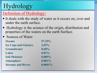
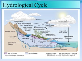
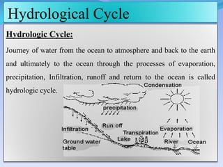
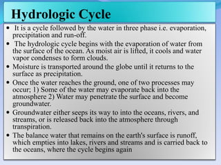
By
Prof. Hole G.R.
Civil Engineering Department
J.S.Polytechnic, Hadapsar,Pune
Content
 Definition of Hydrology
 Hydrological Cycle.
 Important terminology.
 Rain gauge and Rainfall Calculation.
 Numerical on Average rainfall Calculation
 Runoff ,Factors Affecting Runoff and Runoff computation.
 Concept of MFD
 Yield and Dependable Yield of catchment.
 Numerical on Dependable Yield.
Hydrology
Definition of Hydrology:
 It deals with the study of water as it occurs on, over and
under the earth surface.
 Hydrology is the science of the origin, distribution and
properties of the waters on the earth Surface.
 Sources of Water:
Oceans 97.25%
Ice Caps and Glaciers 2.05%
Groundwater 0.68%
Lakes 0.01%
Soil Moisture 0.005%
Atmosphere 0.001%
Streams and Rivers 0.0001%
Hydrological Cycle
Hydrological Cycle
Hydrologic Cycle:
Journey of water from the ocean to atmosphere and back to the earth
and ultimately to the ocean through the processes of evaporation,
precipitation, Infiltration, runoff and return to the ocean is called
hydrologic cycle.
Hydrologic Cycle
 It is a cycle followed by the water in three phase i.e. evaporation,
precipitation and run-off.
 The hydrologic cycle begins with the evaporation of water from
the surface of the ocean. As moist air is lifted, it cools and water
vapor condenses to form clouds.
 Moisture is transported around the globe until it returns to the
surface as precipitation.
 Once the water reaches the ground, one of two processes may
occur; 1) Some of the water may evaporate back into the
atmosphere 2) Water may penetrate the surface and become
groundwater.
 Groundwater either seeps its way to into the oceans, rivers, and
streams, or is released back into the atmosphere through
transpiration.
 The balance water that remains on the earth's surface is runoff,
which empties into lakes, rivers and streams and is carried back to
the oceans, where the cycle begins again
Components of Hydrologic Cycle :
 Precipitation: Includes rain, snow and other forms of
water falling from the atmosphere into the land & oceans.
 Evaporation: Physical process by which water is
vaporized into the atmosphere from free water surface
and land areas.
 Transpiration: Water from the soil is absorbed by plant
roots and eventually discharged into the atmosphere
through little pores in the leaves called stomata.
 Evapotranspiration: Combined processes by which
water is transferred to the atmosphere from open water
surfaces and vegetation.
Components of Hydrologic Cycle
 Infiltration: Movement of water from the land surface to
the upper layers of the soil.
 Percolation: Movement of water through the subsurface
down to the water table.
 Overland flow: Portion of runoff that travels over the
surface of the ground to reach a stream channel
 Surface runoff: Includes all overland flow as well as
precipitation falling directly onto stream channels.
Forms of Precipitation
Definition:-
“Precipitation is any product of the condensation of atmospheric
water vapor that falls under gravity from clouds”
 Liquid Precipitation = Rainfall
 Solid Precipitation = 1) Snow 2) Hail 3) Sleet
Types of Precipitation
 Orographic Precipitation
 Convective Precipitation
 Cyclonic Precipitation
1. Orographic Precipitation:-
• In this type of precipitation ,
Moist air mass get lifted up to
higher elevation due presence of
mountain barrier , Due to rise of
moist air it undergoes cooling,
condensation and precipitation.
• Windward side receives more
precipitation than Leeward side.
• In India most of Rainfall is
occurred due to Orographic
Precipitation.
Types of Precipitation
2. Convective Precipitation
 It is occurred due to if the air
parcel is warmer than
surrounding air, it start moving
in upward direction and empty
space near ground is occupied by
cold air and precipitation
occurred is called convective
Precipitation.
 It gives High Intensity Rainfall
but Short Duration
 Areal Extent of such type of
precipitation is small i.e. @ 10
km in radius.
Types of Precipitation
3. Cyclonic Precipitation
 Cyclone is occurred due to large
low pressure region with circular
wind motion.
 If the two different air masses
warm and cold meets each other
the warmer air mass start moves
in upward direction and start
cooling and water vapor in air
start condense and clouds are
formed which causes
precipitation.
 It is also called Frontal
Precipitation.
Rainfall
 Definition:-
“It is the form precipitation which comes on earth surface in
the form of water then it is called as Rainfall”
 Factors affecting Rainfall:-
1. Temperature
2. Topography
3. Vegetation
4. Altitude
5. Relative humidity
6. Wind
Important Definitions
 Intensity of Rainfall:
It is rainfall occurred per unit time is called Intensity of Rainfall
e.g. if 18 cm rain fall in 3 hours, Intensity of rain fall= 6 cm/hr
 Daily Rainfall:-
It is the total rainfall occurred during 1 day.
e.g. if Rainfall received from 8.30am on 21 july to 8.30am 22 july is 50mm then Daily
Rainfall = 50mm/day
 Annual Rainfall:-
It is the total amount of rainfall(mm,cm) occurred at particular
station during one year
 Average annual rainfall:
Rainfall occurred in last 35 year at any rain gauge Station
Daily rainfall =
𝑇𝑜𝑡𝑎𝑙 𝑅𝑎𝑖𝑛𝑓𝑎𝑙𝑙 𝑅𝑒𝑐𝑖𝑣𝑒𝑑(𝑚𝑚)
𝐷𝑎𝑦
Important Definitions
 Average Good Year of Rainfall:
“ It is an year in which rainfall occurred is more than 20% of average annual
rainfall then it is called as Average Good Year Rainfall”
e.g. If avg. Annual Rainfall = 150cm
( Avg. Good Year Rainfall) = 120% *( 150cm )
= 180cm
 Average Bad Year of Rainfall:
It is an year in which rainfall occurred is less than 20% of average annual rainfall
then it is called as Average Good Year Rainfall”
e.g. If avg. Annual Rainfall = 150cm
( Avg. Bad Year Rainfall) = 80% *( 150cm )
= 120cm
Avg. Good Year Rainfall = 120% *( Avg. Annual Rainfall)
Avg. Bad Year Rainfall = 80% * ( Avg. Annual Rainfall)
Rainfall Measurement
Rainfall measurement at any station is taken daily at 8.30am because
environment is stable during this time so it will give accurate value.
 Rain Gauge :-
“The measurement of rainfall at a place is measured by instrument
and the instrument which measures rainfall is called as rain gauge.”
 Rain Gauge Station:
“The place at which rain gauge are installed for measurement of
rainfall is called as rain gauge station”
Site Selection Criterion for Rain Gauge Station
1. Site should be in open space having at least an area of 5.5mx5.5m.
2. The distance of instrument from nearest obstruction should not be
less than 30m or twice the height of obstruction.
3. The gauge should have level horizontal catch surface.
4. Fence should be erected around rain gauge station. To protect rain
gauge from cattle, dogs etc.
5. The distance of fence should not be less than twice of its height.
6. A site that is sheltered from high wind.
Types of Rain Gauge
1. Automatic ( Recording) type Rain gauge
a. Weighing bucket gauge
b. Tipping bucket gauge
c. Syphon gauge (Float type rain gauge)
2. Non-Automatic ( Non Recording ) Type Rain gauge
a. Symons Non-automatic Rain Gauge
Non-Automatic Rain Gauge:-
Symons Non-automatic Rain Gauge
• Simon’s rain gauge is a non recording
type of rain gauge which is most
commonly used in India.
• It consists of metal casing of
diameter 127mm which is set on a
concrete foundation.
• A glass bottle of capacity about
100mm of rainfall is placed within
the casing.
• A funnel with brass rim is placed on
the top of the bottle.
• The rainfall is recorded at every 24
hours.
• To measure the amount of rainfall.
the glass bottle is taken off and the
collected water is measured in a
measuring glass and recorded in rain
gauge record book
Automatic Rain Gauge:-
1. Weighing bucket gauge
1. It is the type of automatic rain gage in which rainfall is
measured on the basis of weight of water collected in
collecting bucket.
2. In this collector are connect to bucket which is mounted on
Weighing mechanism.
3. When weight of bucket is increased due to rain water the
weighing platform moves.
4. Movement of weighing platform is transmitted to Links and
levers to a pen arm. This pen traces the collected amount of
rainfall on a graduated graph paper wrapped around drum.
5. Thus increasing weight of the bucket helps in recording the
rainfall with time by moving a pen on a revolving drum
6. The instrument gives a plot of accumulated rainfall against
time.
Automatic Rain Gauge:-
2. Tipping bucket gauge:-
1. A Steven’s tipping bucket type rain gauge consist of 30 cm dia.
Sharp edge receiver End of the receiver is provided with funnel.
2. A pair of bucket is provided under the funnel in such a way that
one bucket receives 0.25 mm of precipitation .it tips, discharging
its content to container brining the other bucket the funnel.
3. Tipping of the bucket completes an electric circuit causing
movement of pen to mark on clock driven revolving drum which
carries a record sheet.
4. The electric pulses are generated due to tipping of bucket is
recorded at the control room far away from the rain gauge station.
Automatic Rain Gauge:-
3. Syphon/ Floating Rain gauge
1. In this the rainfall collected by a funnel shaped collector is led
into a float chamber causing a float to rise.
2. A float is provided at the bottom of the container.
3. The float is raise as the water level rises in the container, its
movement being recorded by a pen moving on a recording drum
actuated by the clock work.
4. When the water level in the container rises so that siphons come
into operation and releases water.
5. Thus all the water in the box is drain out.
Automatic Rain Gauge:-
Rain Gauge Network:-
 Rainfall measurement is a most important hydrological parameter.
 Distribution of No. of rain gauge station in a catchment Area should
be such away that it should give accurate Data.
 So rain gauge station should be uniformly distributed over
catchment area.
 The no. of rain gauge station installed should not be too many it
will increase the cost of installation.
 The no. of Rain Gauge station installed should not be too less,
because it will not give accurate Data.
 So we have to provide the optimum no. of rain gauge station over a
particular catchment area so that it will give accurate result in
optimum cost.
Rain Gauge Network:-
 As per IS Standards the Minimum no. of Rain Gauge
Station:-
Sr. No. Area No Rain Gauge Station
1 Plane Area 1 per 520 km2
2 Area having elevation having
greater than 1000m
1 per 260-300 km2
3 Hilly area / Heavy Rainfall 1 per 130 km2
Calculation of Avg. Rainfall:-
The estimation of average rainfall over a catchment area is
calculated by using following methods:-
1. Arithmetic Mean Method
2. Thiesson Polygon Method
3. Isohytal Method
1. Arithmetic Mean Method
 This is a simple method of determining average annual rainfall
using simple arithmetical formula.
 For this we require rainfall data of various years, based on which
we can calculate average annual rainfall.
 If there is “N” of rain gauge station distributed over C.A and
P1, P2, P3 ……..Pn are the Rainfall values recorded over each
station, then average rainfall is calculated as,
1. Arithmetic Mean Method
2. Thiesson Polygon Method
 In this method, the rainfall recorded at each station is given a
weightage on the basis of an area closest to that station.
 Following are steps followed in this method:-
1. Draw the catchment area to a scale and mark the rain gauge
stations on it.
2. Join each station by straight line to create a triangulated network.
2. Thiesson Polygon Method
3. Draw perpendicular bisectors on each sides of each triangles.
Extend the bisectors to meet the other bisectors and the catchment
boundary.
4. The polygons formed by the perpendicular bisectors (and part of
catchment boundary) are the influence areas of each stations.
2. Thiesson Polygon Method
5. If there are n number of rain gauge stations in and around the
catchment and if A1 ,A2 , . . . ,An are the respective influence areas
of Thiesson Polygon and P1, P2, ….Pn are the rainfall values
recorded at each station then the average rainfall is given by
2. Thiesson Polygon Method
3. Isohytal Method
 Isohyets are the contours of equal rainfall.
 In this method rainfall values recorded at various rain gauge
stations are collected and from that Isohytal map is prepared.
 The area between Two successive isohyets is measured with the
help of planimeter.
 Let them be A1,A2,A3,…An and the average rainfall for these
areas are P1,P2,P3…Pn then,
3. Isohytal Method
Runoff
Run off:
“It Is the portion of rainfall which flows through the rivers,
streams etc.”
Types of Runoff
1) Surface Runoff :-
It is the Portion of rainfall after all losses
such as interception, infiltration,
depression storage etc. are enter streams
immediately after occurring rainfall is
called Surface Runoff.
2) Subsurface runoff –(Interflow)
Amount of rainfall first enter into
soil and then flows laterally towards
stream without joining water table
Base flow – Delayed flow –
Water that meets the groundwater table and join the stream or ocean – Very
slow movement and take months or years to reach streams
Factors affecting Runoff
Runoff Calculation Methods
Inglis Method
Strange’s Method
Binnie’s Method
Runoff Coefficient Method
Inglish Method:-
He derives formula for catchment in west maharashtra and divided the area as ghat
(sahyadri ranges) where rainfall is 200mm or more and non ghat where rainfall is
less than 200cm and is given by
 For Ghat Areas( When P > 200 cm)
 For Non-Ghat Area ( When P < 200cm)
P = Precipitation(cm)
R(cm)=(0.84*P -30.54)
R(cm)=𝑥 =
𝑃 ∗( 𝑃−17.74)
254
Runoff Calculation Methods
 Runoff Coefficient Method:
- It is applicable only for small projects
-
Where,
k = Runoff Coefficient
R = Runoff in (cm)
P = Rainfall in (cm)
R(cm)= k * P
Types of Surface K value
Forest 0.05- 0.02
Road Pavement 0.85
Urban Area 0.30-0.50
Park, Farms 0.05-0.03
Commercial & Industrial 0.9
Maximum Flood Discharge(MFD)
Maximum Flood Discharge: (MFD)
 Maximum flood discharge is maximum concentration of flow
from a catchment area at the outlet in small period.
 It is expressed as volume per-unit time i.e. m3/s. cumecs or
cubic meter per seconds.
 Maximum flood discharge gives maximum discharge of river
during flood which is useful for safety of reservoir.
Methods to calculate MFD
1. Empirical Formula:-
2. Dickens Formula
3. Reaves Formula
4. Inglish Formula
Methods to calculate MFD
River Gauging
• It is observation of flood water level and velocity by current
meter. The cross section of the stream is plotted up to flood
level and discharge is obtained by
• Q=AV
• But the record for highest likely flood may not be available
and hence it is customary to base the design on empirical
formulae and subsequently verify the results by steam gauging.
Introduction to Hydrology

Introduction to Hydrology

  • 1.
    By Prof. Hole G.R. CivilEngineering Department J.S.Polytechnic, Hadapsar,Pune
  • 2.
    Content  Definition ofHydrology  Hydrological Cycle.  Important terminology.  Rain gauge and Rainfall Calculation.  Numerical on Average rainfall Calculation  Runoff ,Factors Affecting Runoff and Runoff computation.  Concept of MFD  Yield and Dependable Yield of catchment.  Numerical on Dependable Yield.
  • 3.
    Hydrology Definition of Hydrology: It deals with the study of water as it occurs on, over and under the earth surface.  Hydrology is the science of the origin, distribution and properties of the waters on the earth Surface.  Sources of Water: Oceans 97.25% Ice Caps and Glaciers 2.05% Groundwater 0.68% Lakes 0.01% Soil Moisture 0.005% Atmosphere 0.001% Streams and Rivers 0.0001%
  • 4.
  • 5.
    Hydrological Cycle Hydrologic Cycle: Journeyof water from the ocean to atmosphere and back to the earth and ultimately to the ocean through the processes of evaporation, precipitation, Infiltration, runoff and return to the ocean is called hydrologic cycle.
  • 6.
    Hydrologic Cycle  Itis a cycle followed by the water in three phase i.e. evaporation, precipitation and run-off.  The hydrologic cycle begins with the evaporation of water from the surface of the ocean. As moist air is lifted, it cools and water vapor condenses to form clouds.  Moisture is transported around the globe until it returns to the surface as precipitation.  Once the water reaches the ground, one of two processes may occur; 1) Some of the water may evaporate back into the atmosphere 2) Water may penetrate the surface and become groundwater.  Groundwater either seeps its way to into the oceans, rivers, and streams, or is released back into the atmosphere through transpiration.  The balance water that remains on the earth's surface is runoff, which empties into lakes, rivers and streams and is carried back to the oceans, where the cycle begins again
  • 7.
    Components of HydrologicCycle :  Precipitation: Includes rain, snow and other forms of water falling from the atmosphere into the land & oceans.  Evaporation: Physical process by which water is vaporized into the atmosphere from free water surface and land areas.  Transpiration: Water from the soil is absorbed by plant roots and eventually discharged into the atmosphere through little pores in the leaves called stomata.  Evapotranspiration: Combined processes by which water is transferred to the atmosphere from open water surfaces and vegetation.
  • 8.
    Components of HydrologicCycle  Infiltration: Movement of water from the land surface to the upper layers of the soil.  Percolation: Movement of water through the subsurface down to the water table.  Overland flow: Portion of runoff that travels over the surface of the ground to reach a stream channel  Surface runoff: Includes all overland flow as well as precipitation falling directly onto stream channels.
  • 9.
    Forms of Precipitation Definition:- “Precipitationis any product of the condensation of atmospheric water vapor that falls under gravity from clouds”  Liquid Precipitation = Rainfall  Solid Precipitation = 1) Snow 2) Hail 3) Sleet
  • 10.
    Types of Precipitation Orographic Precipitation  Convective Precipitation  Cyclonic Precipitation 1. Orographic Precipitation:- • In this type of precipitation , Moist air mass get lifted up to higher elevation due presence of mountain barrier , Due to rise of moist air it undergoes cooling, condensation and precipitation. • Windward side receives more precipitation than Leeward side. • In India most of Rainfall is occurred due to Orographic Precipitation.
  • 11.
    Types of Precipitation 2.Convective Precipitation  It is occurred due to if the air parcel is warmer than surrounding air, it start moving in upward direction and empty space near ground is occupied by cold air and precipitation occurred is called convective Precipitation.  It gives High Intensity Rainfall but Short Duration  Areal Extent of such type of precipitation is small i.e. @ 10 km in radius.
  • 12.
    Types of Precipitation 3.Cyclonic Precipitation  Cyclone is occurred due to large low pressure region with circular wind motion.  If the two different air masses warm and cold meets each other the warmer air mass start moves in upward direction and start cooling and water vapor in air start condense and clouds are formed which causes precipitation.  It is also called Frontal Precipitation.
  • 13.
    Rainfall  Definition:- “It isthe form precipitation which comes on earth surface in the form of water then it is called as Rainfall”  Factors affecting Rainfall:- 1. Temperature 2. Topography 3. Vegetation 4. Altitude 5. Relative humidity 6. Wind
  • 14.
    Important Definitions  Intensityof Rainfall: It is rainfall occurred per unit time is called Intensity of Rainfall e.g. if 18 cm rain fall in 3 hours, Intensity of rain fall= 6 cm/hr  Daily Rainfall:- It is the total rainfall occurred during 1 day. e.g. if Rainfall received from 8.30am on 21 july to 8.30am 22 july is 50mm then Daily Rainfall = 50mm/day  Annual Rainfall:- It is the total amount of rainfall(mm,cm) occurred at particular station during one year  Average annual rainfall: Rainfall occurred in last 35 year at any rain gauge Station Daily rainfall = 𝑇𝑜𝑡𝑎𝑙 𝑅𝑎𝑖𝑛𝑓𝑎𝑙𝑙 𝑅𝑒𝑐𝑖𝑣𝑒𝑑(𝑚𝑚) 𝐷𝑎𝑦
  • 15.
    Important Definitions  AverageGood Year of Rainfall: “ It is an year in which rainfall occurred is more than 20% of average annual rainfall then it is called as Average Good Year Rainfall” e.g. If avg. Annual Rainfall = 150cm ( Avg. Good Year Rainfall) = 120% *( 150cm ) = 180cm  Average Bad Year of Rainfall: It is an year in which rainfall occurred is less than 20% of average annual rainfall then it is called as Average Good Year Rainfall” e.g. If avg. Annual Rainfall = 150cm ( Avg. Bad Year Rainfall) = 80% *( 150cm ) = 120cm Avg. Good Year Rainfall = 120% *( Avg. Annual Rainfall) Avg. Bad Year Rainfall = 80% * ( Avg. Annual Rainfall)
  • 16.
    Rainfall Measurement Rainfall measurementat any station is taken daily at 8.30am because environment is stable during this time so it will give accurate value.  Rain Gauge :- “The measurement of rainfall at a place is measured by instrument and the instrument which measures rainfall is called as rain gauge.”  Rain Gauge Station: “The place at which rain gauge are installed for measurement of rainfall is called as rain gauge station”
  • 17.
    Site Selection Criterionfor Rain Gauge Station 1. Site should be in open space having at least an area of 5.5mx5.5m. 2. The distance of instrument from nearest obstruction should not be less than 30m or twice the height of obstruction. 3. The gauge should have level horizontal catch surface. 4. Fence should be erected around rain gauge station. To protect rain gauge from cattle, dogs etc. 5. The distance of fence should not be less than twice of its height. 6. A site that is sheltered from high wind.
  • 18.
    Types of RainGauge 1. Automatic ( Recording) type Rain gauge a. Weighing bucket gauge b. Tipping bucket gauge c. Syphon gauge (Float type rain gauge) 2. Non-Automatic ( Non Recording ) Type Rain gauge a. Symons Non-automatic Rain Gauge
  • 19.
    Non-Automatic Rain Gauge:- SymonsNon-automatic Rain Gauge • Simon’s rain gauge is a non recording type of rain gauge which is most commonly used in India. • It consists of metal casing of diameter 127mm which is set on a concrete foundation. • A glass bottle of capacity about 100mm of rainfall is placed within the casing. • A funnel with brass rim is placed on the top of the bottle. • The rainfall is recorded at every 24 hours. • To measure the amount of rainfall. the glass bottle is taken off and the collected water is measured in a measuring glass and recorded in rain gauge record book
  • 20.
    Automatic Rain Gauge:- 1.Weighing bucket gauge 1. It is the type of automatic rain gage in which rainfall is measured on the basis of weight of water collected in collecting bucket. 2. In this collector are connect to bucket which is mounted on Weighing mechanism. 3. When weight of bucket is increased due to rain water the weighing platform moves. 4. Movement of weighing platform is transmitted to Links and levers to a pen arm. This pen traces the collected amount of rainfall on a graduated graph paper wrapped around drum. 5. Thus increasing weight of the bucket helps in recording the rainfall with time by moving a pen on a revolving drum 6. The instrument gives a plot of accumulated rainfall against time.
  • 21.
  • 22.
    Automatic Rain Gauge:- 2.Tipping bucket gauge:- 1. A Steven’s tipping bucket type rain gauge consist of 30 cm dia. Sharp edge receiver End of the receiver is provided with funnel. 2. A pair of bucket is provided under the funnel in such a way that one bucket receives 0.25 mm of precipitation .it tips, discharging its content to container brining the other bucket the funnel. 3. Tipping of the bucket completes an electric circuit causing movement of pen to mark on clock driven revolving drum which carries a record sheet. 4. The electric pulses are generated due to tipping of bucket is recorded at the control room far away from the rain gauge station.
  • 23.
  • 24.
    Automatic Rain Gauge:- 3.Syphon/ Floating Rain gauge 1. In this the rainfall collected by a funnel shaped collector is led into a float chamber causing a float to rise. 2. A float is provided at the bottom of the container. 3. The float is raise as the water level rises in the container, its movement being recorded by a pen moving on a recording drum actuated by the clock work. 4. When the water level in the container rises so that siphons come into operation and releases water. 5. Thus all the water in the box is drain out.
  • 25.
  • 26.
    Rain Gauge Network:- Rainfall measurement is a most important hydrological parameter.  Distribution of No. of rain gauge station in a catchment Area should be such away that it should give accurate Data.  So rain gauge station should be uniformly distributed over catchment area.  The no. of rain gauge station installed should not be too many it will increase the cost of installation.  The no. of Rain Gauge station installed should not be too less, because it will not give accurate Data.  So we have to provide the optimum no. of rain gauge station over a particular catchment area so that it will give accurate result in optimum cost.
  • 27.
    Rain Gauge Network:- As per IS Standards the Minimum no. of Rain Gauge Station:- Sr. No. Area No Rain Gauge Station 1 Plane Area 1 per 520 km2 2 Area having elevation having greater than 1000m 1 per 260-300 km2 3 Hilly area / Heavy Rainfall 1 per 130 km2
  • 28.
    Calculation of Avg.Rainfall:- The estimation of average rainfall over a catchment area is calculated by using following methods:- 1. Arithmetic Mean Method 2. Thiesson Polygon Method 3. Isohytal Method
  • 29.
    1. Arithmetic MeanMethod  This is a simple method of determining average annual rainfall using simple arithmetical formula.  For this we require rainfall data of various years, based on which we can calculate average annual rainfall.  If there is “N” of rain gauge station distributed over C.A and P1, P2, P3 ……..Pn are the Rainfall values recorded over each station, then average rainfall is calculated as,
  • 30.
  • 31.
    2. Thiesson PolygonMethod  In this method, the rainfall recorded at each station is given a weightage on the basis of an area closest to that station.  Following are steps followed in this method:- 1. Draw the catchment area to a scale and mark the rain gauge stations on it. 2. Join each station by straight line to create a triangulated network.
  • 32.
    2. Thiesson PolygonMethod 3. Draw perpendicular bisectors on each sides of each triangles. Extend the bisectors to meet the other bisectors and the catchment boundary. 4. The polygons formed by the perpendicular bisectors (and part of catchment boundary) are the influence areas of each stations.
  • 33.
    2. Thiesson PolygonMethod 5. If there are n number of rain gauge stations in and around the catchment and if A1 ,A2 , . . . ,An are the respective influence areas of Thiesson Polygon and P1, P2, ….Pn are the rainfall values recorded at each station then the average rainfall is given by
  • 34.
  • 35.
    3. Isohytal Method Isohyets are the contours of equal rainfall.  In this method rainfall values recorded at various rain gauge stations are collected and from that Isohytal map is prepared.  The area between Two successive isohyets is measured with the help of planimeter.  Let them be A1,A2,A3,…An and the average rainfall for these areas are P1,P2,P3…Pn then,
  • 36.
  • 37.
    Runoff Run off: “It Isthe portion of rainfall which flows through the rivers, streams etc.”
  • 38.
    Types of Runoff 1)Surface Runoff :- It is the Portion of rainfall after all losses such as interception, infiltration, depression storage etc. are enter streams immediately after occurring rainfall is called Surface Runoff. 2) Subsurface runoff –(Interflow) Amount of rainfall first enter into soil and then flows laterally towards stream without joining water table Base flow – Delayed flow – Water that meets the groundwater table and join the stream or ocean – Very slow movement and take months or years to reach streams
  • 39.
  • 40.
  • 41.
    Runoff Calculation Methods InglisMethod Strange’s Method Binnie’s Method Runoff Coefficient Method Inglish Method:- He derives formula for catchment in west maharashtra and divided the area as ghat (sahyadri ranges) where rainfall is 200mm or more and non ghat where rainfall is less than 200cm and is given by  For Ghat Areas( When P > 200 cm)  For Non-Ghat Area ( When P < 200cm) P = Precipitation(cm) R(cm)=(0.84*P -30.54) R(cm)=𝑥 = 𝑃 ∗( 𝑃−17.74) 254
  • 42.
    Runoff Calculation Methods Runoff Coefficient Method: - It is applicable only for small projects - Where, k = Runoff Coefficient R = Runoff in (cm) P = Rainfall in (cm) R(cm)= k * P Types of Surface K value Forest 0.05- 0.02 Road Pavement 0.85 Urban Area 0.30-0.50 Park, Farms 0.05-0.03 Commercial & Industrial 0.9
  • 43.
    Maximum Flood Discharge(MFD) MaximumFlood Discharge: (MFD)  Maximum flood discharge is maximum concentration of flow from a catchment area at the outlet in small period.  It is expressed as volume per-unit time i.e. m3/s. cumecs or cubic meter per seconds.  Maximum flood discharge gives maximum discharge of river during flood which is useful for safety of reservoir.
  • 44.
    Methods to calculateMFD 1. Empirical Formula:- 2. Dickens Formula 3. Reaves Formula 4. Inglish Formula
  • 45.
  • 46.
  • 47.
  • 48.
  • 49.
    River Gauging • Itis observation of flood water level and velocity by current meter. The cross section of the stream is plotted up to flood level and discharge is obtained by • Q=AV • But the record for highest likely flood may not be available and hence it is customary to base the design on empirical formulae and subsequently verify the results by steam gauging.