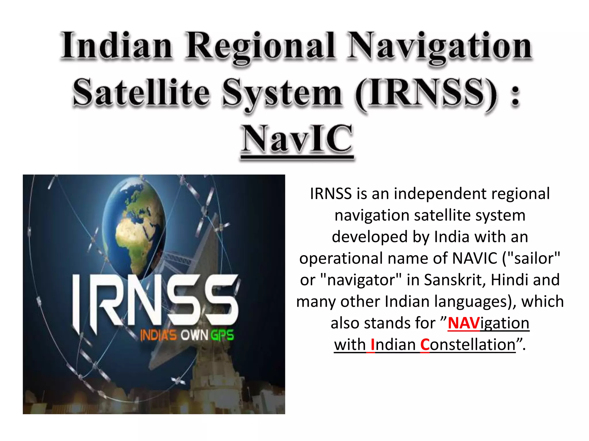
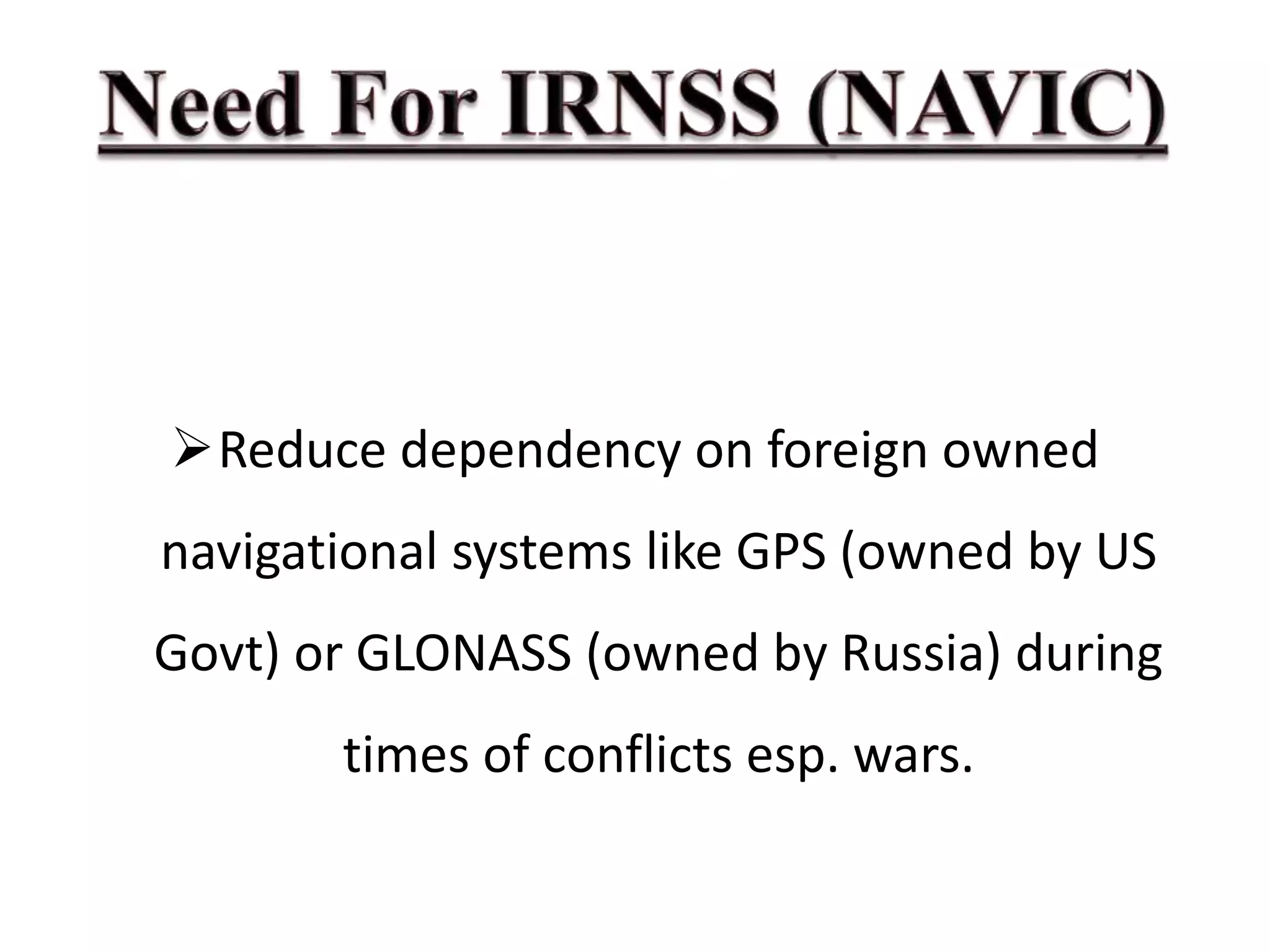
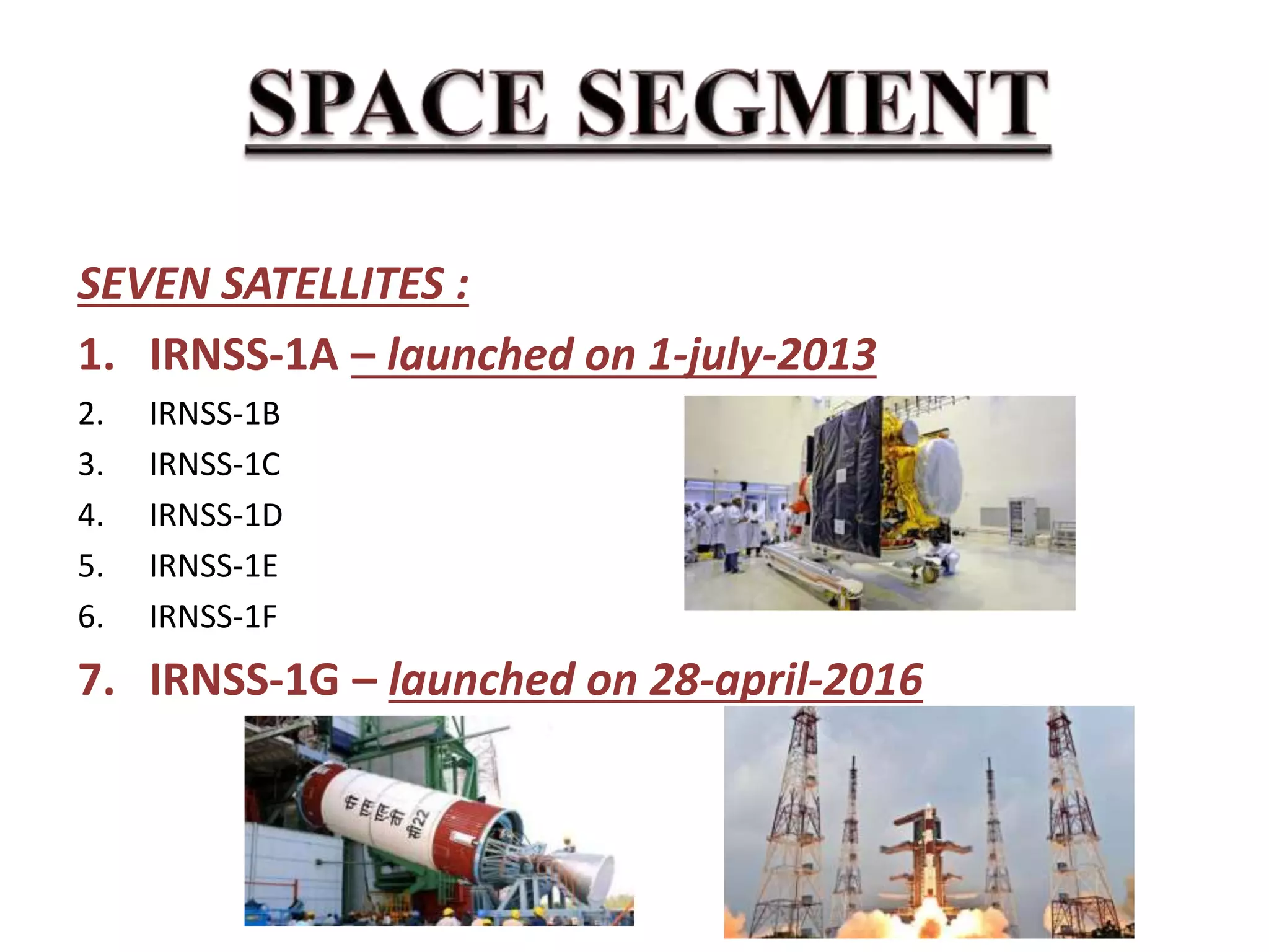
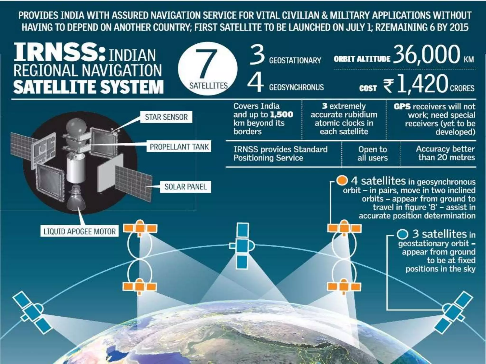
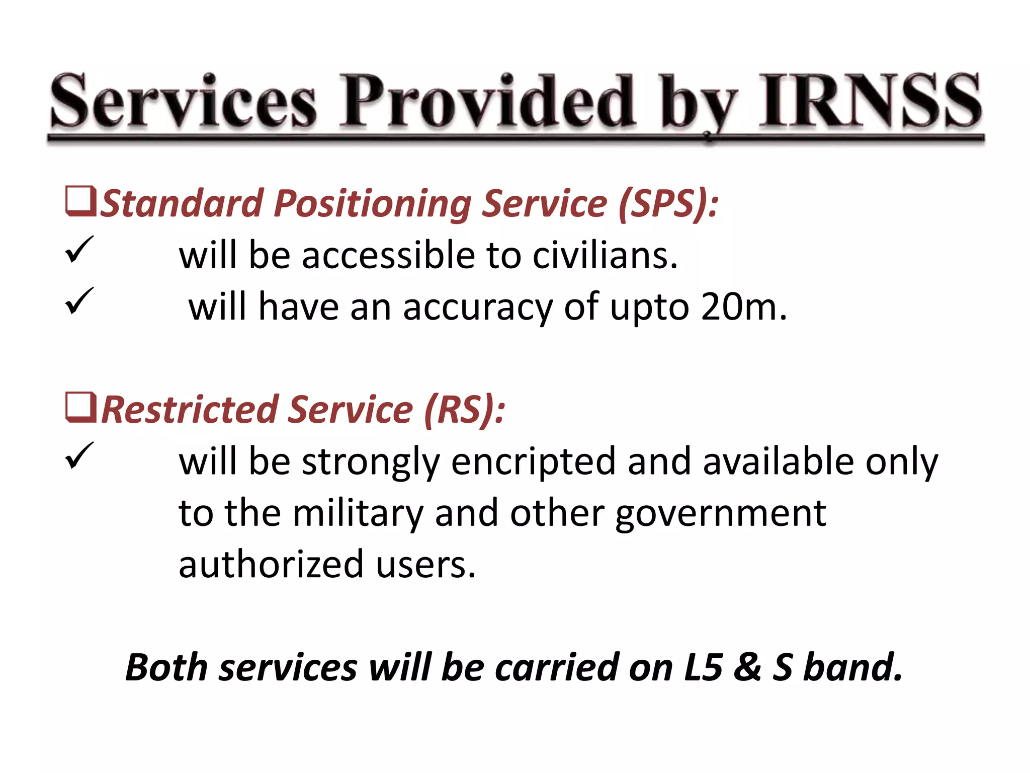
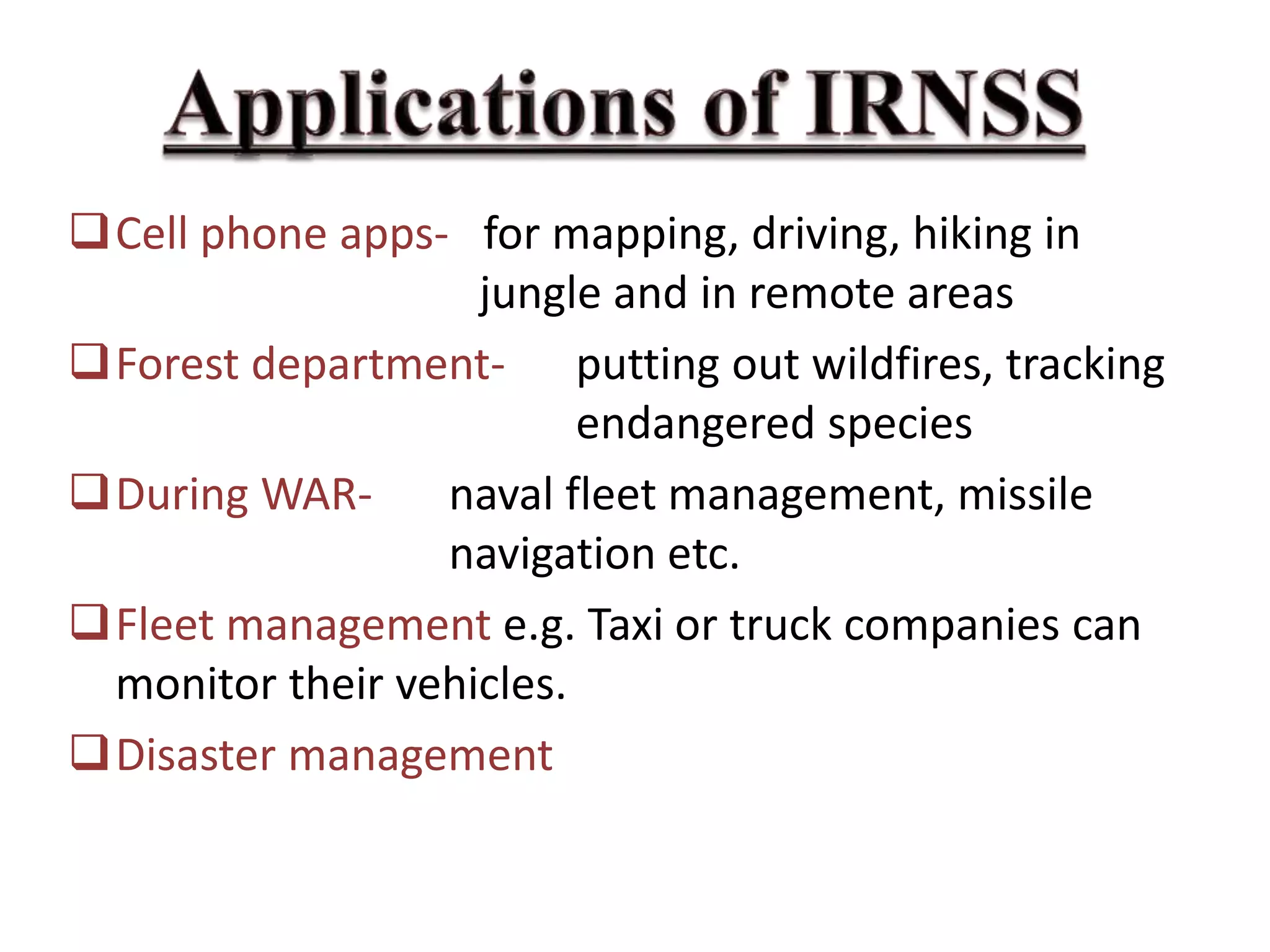
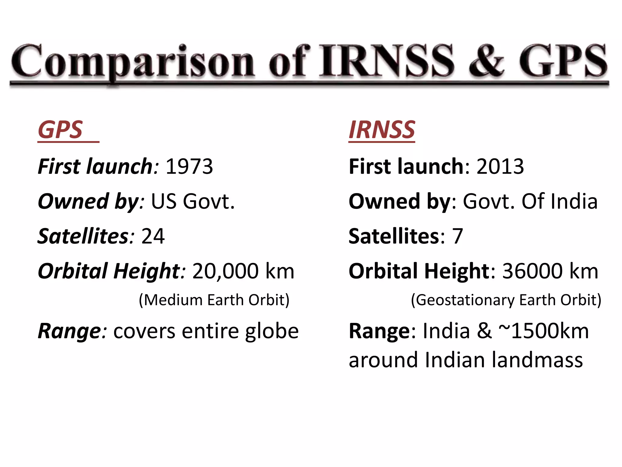
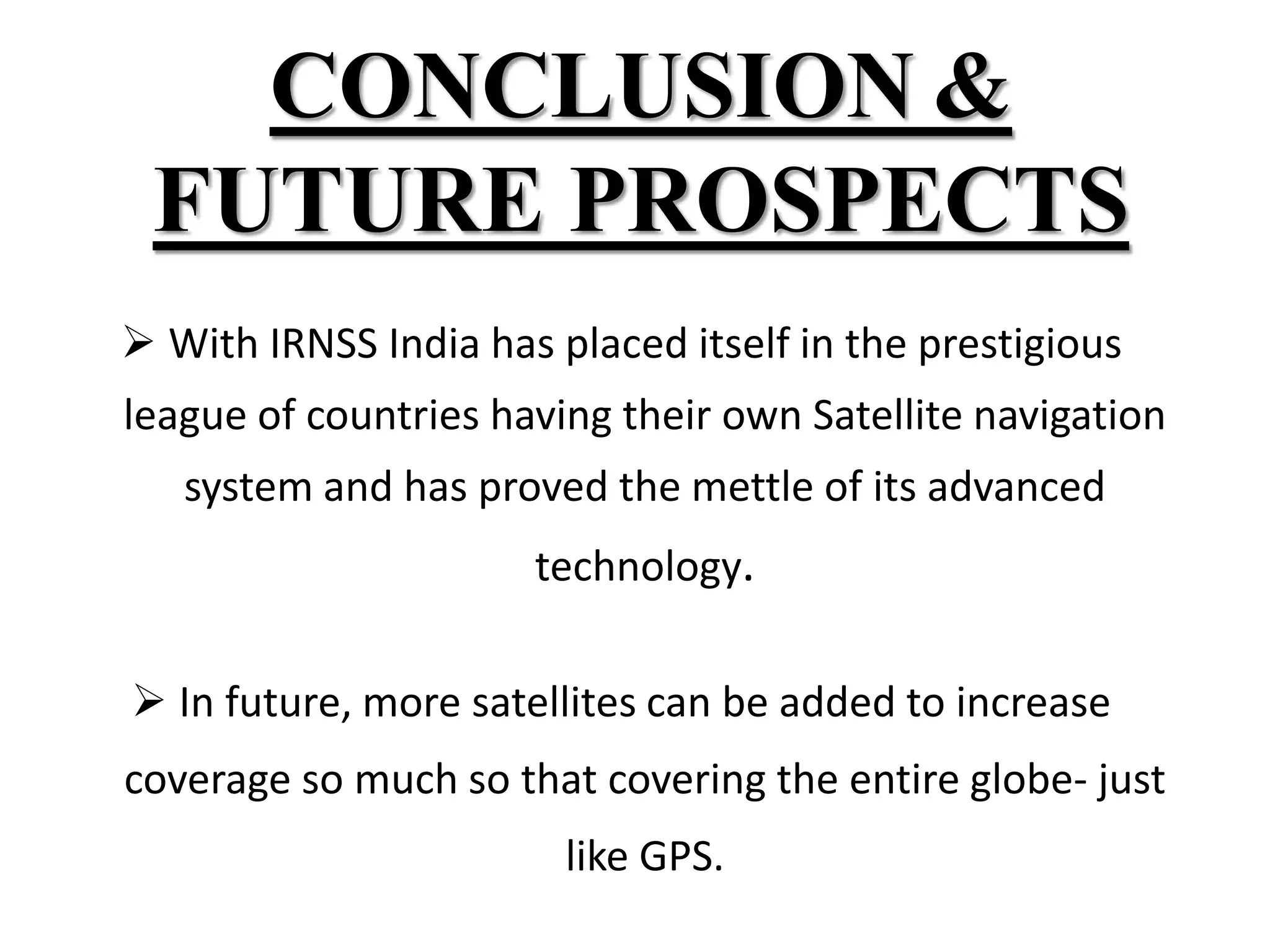
SlideShare a Scribd company logo
ORIENTAL COLLEGE OF TECHNOLOGY
BHOPAL (M.P.)
SUBMITTED TO : SUBMITTED BY :
PROF. KEERTI VERMA UTKARSH GANGWAR
0126cs161117
CSE-B, II SEMESTER
Indian Regional Navigation Satellite
System (IRNSS)
IRNSS is an independent regional
navigation satellite system
developed by India with an
operational name of NAVIC ("sailor"
or "navigator" in Sanskrit, Hindi and
many other Indian languages), which
also stands for ”NAVigation
with Indian Constellation”.
Reduce dependency on foreign owned
navigational systems like GPS (owned by US
Govt) or GLONASS (owned by Russia) during
times of conflicts esp. wars.
Space Segment
User Segment Ground Segment
SEVEN SATELLITES :
1. IRNSS-1A – launched on 1-july-2013
2. IRNSS-1B
3. IRNSS-1C
4. IRNSS-1D
5. IRNSS-1E
6. IRNSS-1F
7. IRNSS-1G – launched on 28-april-2016
IRNSS Space Craft Control Centre (SCC)
IRNSS Navigation Centre (INC)
FUNCTIONS:
Estimating & Predicting IRNSS Satellite positions.
Calculation of integrity
Ionospheric & Clock corrections
Running the navigation software
IRNSS receivers.
DUAL-FREQUENCY:- L5 band: (1164 – 1189) MHz
central freq: 1176.45 MHz
S band: (2483.5 - 2500) MHz
central freq: 2492.028 MHz
SINGLE-FREQUENCY:- either L5 band or S band
These receivers are currently being manufactured and
Will be available soon.
Standard Positioning Service (SPS):
 will be accessible to civilians.
 will have an accuracy of upto 20m.
Restricted Service (RS):
 will be strongly encripted and available only
to the military and other government
authorized users.
Both services will be carried on L5 & S band.
Cell phone apps- for mapping, driving, hiking in
jungle and in remote areas
Forest department- putting out wildfires, tracking
endangered species
During WAR- naval fleet management, missile
navigation etc.
Fleet management e.g. Taxi or truck companies can
monitor their vehicles.
Disaster management
GPS IRNSS
First launch: 1973 First launch: 2013
Owned by: US Govt. Owned by: Govt. Of India
Satellites: 24 Satellites: 7
Orbital Height: 20,000 km Orbital Height: 36000 km
(Medium Earth Orbit) (Geostationary Earth Orbit)
Range: covers entire globe Range: India & ~1500km
around Indian landmass
CONCLUSION &
FUTURE PROSPECTS
 With IRNSS India has placed itself in the prestigious
league of countries having their own Satellite navigation
system and has proved the mettle of its advanced
technology.
 In future, more satellites can be added to increase
coverage so much so that covering the entire globe- just
like GPS.
Irnss paper presentation

More Related Content

What's hot

GAGAN (GPS Aided Geo Augmented Navigation)
GAGAN (GPS Aided Geo Augmented Navigation)GAGAN (GPS Aided Geo Augmented Navigation)
GAGAN (GPS Aided Geo Augmented Navigation)
Prakhar Aditya
 
IRNSS ISRO
IRNSS ISROIRNSS ISRO
IRNSS ISRO
Saad Abbasi
 
IRNSS
IRNSSIRNSS
gps technology
gps technologygps technology
gps technology
Naga Dinesh
 
Global Positing System
Global Positing SystemGlobal Positing System
Global Positing System
Pranay Mondal
 
Introduction to navstar gps
Introduction to navstar gpsIntroduction to navstar gps
Introduction to navstar gpsDocumentStory
 
GAGAN ISRO
GAGAN ISROGAGAN ISRO
GAGAN ISRO
Saad Abbasi
 
Navic
NavicNavic
Global positioning system (GPS)
Global positioning system (GPS)Global positioning system (GPS)
Global positioning system (GPS)
Chandana R
 
Gps
GpsGps
Gagan nav.
Gagan nav.Gagan nav.
Gagan nav.
Manish kajave
 
Indian remote sensing satellites
Indian remote sensing satellitesIndian remote sensing satellites
Indian remote sensing satellites
Hiba Shahid
 
Global positioning system (gps)
Global positioning  system (gps)Global positioning  system (gps)
Global positioning system (gps)
Vandana Verma
 
Optical and infrared remote sensing
Optical and infrared remote sensingOptical and infrared remote sensing
Optical and infrared remote sensing
Neha Sharma
 
Satellites launched by india
Satellites launched by indiaSatellites launched by india
Satellites launched by india
msdoni
 
Introduction of gps global navigation satellite systems
Introduction of gps   global navigation satellite systems Introduction of gps   global navigation satellite systems
Introduction of gps global navigation satellite systems DocumentStory
 
.remote sensing.Ece 402 unit-2
.remote sensing.Ece 402 unit-2.remote sensing.Ece 402 unit-2
.remote sensing.Ece 402 unit-2
Vandana Verma
 
Navic tanish khilani
Navic tanish khilaniNavic tanish khilani
Navic tanish khilani
Tanish Khilani
 
GNSS(GLOBAL NAVIGATION SATELLITE SYSTEM)
GNSS(GLOBAL NAVIGATION SATELLITE SYSTEM)GNSS(GLOBAL NAVIGATION SATELLITE SYSTEM)
GNSS(GLOBAL NAVIGATION SATELLITE SYSTEM)
NinaPlays
 

What's hot (20)

GAGAN (GPS Aided Geo Augmented Navigation)
GAGAN (GPS Aided Geo Augmented Navigation)GAGAN (GPS Aided Geo Augmented Navigation)
GAGAN (GPS Aided Geo Augmented Navigation)
 
IRNSS ISRO
IRNSS ISROIRNSS ISRO
IRNSS ISRO
 
IRNSS
IRNSSIRNSS
IRNSS
 
gps technology
gps technologygps technology
gps technology
 
Global Positing System
Global Positing SystemGlobal Positing System
Global Positing System
 
Introduction to navstar gps
Introduction to navstar gpsIntroduction to navstar gps
Introduction to navstar gps
 
GAGAN ISRO
GAGAN ISROGAGAN ISRO
GAGAN ISRO
 
Navic
NavicNavic
Navic
 
Global positioning system (GPS)
Global positioning system (GPS)Global positioning system (GPS)
Global positioning system (GPS)
 
Gps
GpsGps
Gps
 
Gagan nav.
Gagan nav.Gagan nav.
Gagan nav.
 
Indian remote sensing satellites
Indian remote sensing satellitesIndian remote sensing satellites
Indian remote sensing satellites
 
Global positioning system (gps)
Global positioning  system (gps)Global positioning  system (gps)
Global positioning system (gps)
 
Glonass
GlonassGlonass
Glonass
 
Optical and infrared remote sensing
Optical and infrared remote sensingOptical and infrared remote sensing
Optical and infrared remote sensing
 
Satellites launched by india
Satellites launched by indiaSatellites launched by india
Satellites launched by india
 
Introduction of gps global navigation satellite systems
Introduction of gps   global navigation satellite systems Introduction of gps   global navigation satellite systems
Introduction of gps global navigation satellite systems
 
.remote sensing.Ece 402 unit-2
.remote sensing.Ece 402 unit-2.remote sensing.Ece 402 unit-2
.remote sensing.Ece 402 unit-2
 
Navic tanish khilani
Navic tanish khilaniNavic tanish khilani
Navic tanish khilani
 
GNSS(GLOBAL NAVIGATION SATELLITE SYSTEM)
GNSS(GLOBAL NAVIGATION SATELLITE SYSTEM)GNSS(GLOBAL NAVIGATION SATELLITE SYSTEM)
GNSS(GLOBAL NAVIGATION SATELLITE SYSTEM)
 

Similar to Irnss paper presentation

oLRHR5LYJLR1IggX333.pptx
oLRHR5LYJLR1IggX333.pptxoLRHR5LYJLR1IggX333.pptx
oLRHR5LYJLR1IggX333.pptx
VishuBaniyan
 
Indian Regional Navigational Satellite System (IRNSS)
Indian Regional Navigational Satellite System (IRNSS)Indian Regional Navigational Satellite System (IRNSS)
Indian Regional Navigational Satellite System (IRNSS)
Yelendher Reddy
 
INDIAN REGIONAL NAVIGATIONAL SATELLITE SYSTEM (IRNSS)
INDIAN REGIONAL NAVIGATIONAL SATELLITE SYSTEM (IRNSS)INDIAN REGIONAL NAVIGATIONAL SATELLITE SYSTEM (IRNSS)
INDIAN REGIONAL NAVIGATIONAL SATELLITE SYSTEM (IRNSS)
Yelendher Reddy
 
Rahul singh
Rahul singhRahul singh
Rahul singh
rahul singh
 
All Missions by ISRO in 2018.
All Missions by ISRO in 2018.All Missions by ISRO in 2018.
All Missions by ISRO in 2018.
Haruhit Kunwar
 
IRNSS by Anish Raj Goyal
IRNSS by Anish Raj GoyalIRNSS by Anish Raj Goyal
IRNSS by Anish Raj Goyal
Anish Raj Goyal
 
Navic india's own navigation system
Navic india's own navigation systemNavic india's own navigation system
Navic india's own navigation system
vishnu murthy
 
Indian Remote Sensing satellites (IRS).pptx
Indian Remote Sensing satellites (IRS).pptxIndian Remote Sensing satellites (IRS).pptx
Indian Remote Sensing satellites (IRS).pptx
sapna kinattinkara
 
Intro to RS and GIS by mndp poonia
Intro to RS and GIS by mndp pooniaIntro to RS and GIS by mndp poonia
Intro to RS and GIS by mndp poonia
mndp_slide
 
Latest trends in satellite communication
Latest trends in satellite communicationLatest trends in satellite communication
Latest trends in satellite communicationjasspreetkaurr
 
Abstract IRNSS Architecture and Applications
Abstract  IRNSS Architecture and ApplicationsAbstract  IRNSS Architecture and Applications
Abstract IRNSS Architecture and Applications
vishnu murthy
 
International Goals in Space, Indian Space Program
International Goals in Space, Indian Space ProgramInternational Goals in Space, Indian Space Program
International Goals in Space, Indian Space Program
American Astronautical Society
 
Indian Regional Navigation Satellite System
Indian Regional Navigation Satellite SystemIndian Regional Navigation Satellite System
Indian Regional Navigation Satellite System
NishaRajput59
 
Department of Space, Government of India - Year End Review 2014
Department of Space, Government of India - Year End Review 2014Department of Space, Government of India - Year End Review 2014
Department of Space, Government of India - Year End Review 2014
D Murali ☆
 
Indian space program june 2014
Indian space program june 2014Indian space program june 2014
Indian space program june 2014
Vikram Subramanyam
 
IRS satallites
IRS satallitesIRS satallites
IRS satallites
Bharath YG
 
VISION AND MISSION OF ISRO
VISION AND MISSION OF ISRO VISION AND MISSION OF ISRO
VISION AND MISSION OF ISRO
akshayattri1
 
GPS AND GLONAS.pptx
GPS AND GLONAS.pptxGPS AND GLONAS.pptx
GPS AND GLONAS.pptx
harshbamniya
 
Global positioning system(GPS)
Global positioning system(GPS)Global positioning system(GPS)
Global positioning system(GPS)
anasali89
 
2016.09.19_15.30_Agency_Reports_ISRO.pptx
2016.09.19_15.30_Agency_Reports_ISRO.pptx2016.09.19_15.30_Agency_Reports_ISRO.pptx
2016.09.19_15.30_Agency_Reports_ISRO.pptx
Manasutthasini2
 

Similar to Irnss paper presentation (20)

oLRHR5LYJLR1IggX333.pptx
oLRHR5LYJLR1IggX333.pptxoLRHR5LYJLR1IggX333.pptx
oLRHR5LYJLR1IggX333.pptx
 
Indian Regional Navigational Satellite System (IRNSS)
Indian Regional Navigational Satellite System (IRNSS)Indian Regional Navigational Satellite System (IRNSS)
Indian Regional Navigational Satellite System (IRNSS)
 
INDIAN REGIONAL NAVIGATIONAL SATELLITE SYSTEM (IRNSS)
INDIAN REGIONAL NAVIGATIONAL SATELLITE SYSTEM (IRNSS)INDIAN REGIONAL NAVIGATIONAL SATELLITE SYSTEM (IRNSS)
INDIAN REGIONAL NAVIGATIONAL SATELLITE SYSTEM (IRNSS)
 
Rahul singh
Rahul singhRahul singh
Rahul singh
 
All Missions by ISRO in 2018.
All Missions by ISRO in 2018.All Missions by ISRO in 2018.
All Missions by ISRO in 2018.
 
IRNSS by Anish Raj Goyal
IRNSS by Anish Raj GoyalIRNSS by Anish Raj Goyal
IRNSS by Anish Raj Goyal
 
Navic india's own navigation system
Navic india's own navigation systemNavic india's own navigation system
Navic india's own navigation system
 
Indian Remote Sensing satellites (IRS).pptx
Indian Remote Sensing satellites (IRS).pptxIndian Remote Sensing satellites (IRS).pptx
Indian Remote Sensing satellites (IRS).pptx
 
Intro to RS and GIS by mndp poonia
Intro to RS and GIS by mndp pooniaIntro to RS and GIS by mndp poonia
Intro to RS and GIS by mndp poonia
 
Latest trends in satellite communication
Latest trends in satellite communicationLatest trends in satellite communication
Latest trends in satellite communication
 
Abstract IRNSS Architecture and Applications
Abstract  IRNSS Architecture and ApplicationsAbstract  IRNSS Architecture and Applications
Abstract IRNSS Architecture and Applications
 
International Goals in Space, Indian Space Program
International Goals in Space, Indian Space ProgramInternational Goals in Space, Indian Space Program
International Goals in Space, Indian Space Program
 
Indian Regional Navigation Satellite System
Indian Regional Navigation Satellite SystemIndian Regional Navigation Satellite System
Indian Regional Navigation Satellite System
 
Department of Space, Government of India - Year End Review 2014
Department of Space, Government of India - Year End Review 2014Department of Space, Government of India - Year End Review 2014
Department of Space, Government of India - Year End Review 2014
 
Indian space program june 2014
Indian space program june 2014Indian space program june 2014
Indian space program june 2014
 
IRS satallites
IRS satallitesIRS satallites
IRS satallites
 
VISION AND MISSION OF ISRO
VISION AND MISSION OF ISRO VISION AND MISSION OF ISRO
VISION AND MISSION OF ISRO
 
GPS AND GLONAS.pptx
GPS AND GLONAS.pptxGPS AND GLONAS.pptx
GPS AND GLONAS.pptx
 
Global positioning system(GPS)
Global positioning system(GPS)Global positioning system(GPS)
Global positioning system(GPS)
 
2016.09.19_15.30_Agency_Reports_ISRO.pptx
2016.09.19_15.30_Agency_Reports_ISRO.pptx2016.09.19_15.30_Agency_Reports_ISRO.pptx
2016.09.19_15.30_Agency_Reports_ISRO.pptx
 

Recently uploaded

Smart TV Buyer Insights Survey 2024 by 91mobiles.pdf
Smart TV Buyer Insights Survey 2024 by 91mobiles.pdfSmart TV Buyer Insights Survey 2024 by 91mobiles.pdf
Smart TV Buyer Insights Survey 2024 by 91mobiles.pdf
91mobiles
 
IOS-PENTESTING-BEGINNERS-PRACTICAL-GUIDE-.pptx
IOS-PENTESTING-BEGINNERS-PRACTICAL-GUIDE-.pptxIOS-PENTESTING-BEGINNERS-PRACTICAL-GUIDE-.pptx
IOS-PENTESTING-BEGINNERS-PRACTICAL-GUIDE-.pptx
Abida Shariff
 
Software Delivery At the Speed of AI: Inflectra Invests In AI-Powered Quality
Software Delivery At the Speed of AI: Inflectra Invests In AI-Powered QualitySoftware Delivery At the Speed of AI: Inflectra Invests In AI-Powered Quality
Software Delivery At the Speed of AI: Inflectra Invests In AI-Powered Quality
Inflectra
 
GraphRAG is All You need? LLM & Knowledge Graph
GraphRAG is All You need? LLM & Knowledge GraphGraphRAG is All You need? LLM & Knowledge Graph
GraphRAG is All You need? LLM & Knowledge Graph
Guy Korland
 
LF Energy Webinar: Electrical Grid Modelling and Simulation Through PowSyBl -...
LF Energy Webinar: Electrical Grid Modelling and Simulation Through PowSyBl -...LF Energy Webinar: Electrical Grid Modelling and Simulation Through PowSyBl -...
LF Energy Webinar: Electrical Grid Modelling and Simulation Through PowSyBl -...
DanBrown980551
 
"Impact of front-end architecture on development cost", Viktor Turskyi
"Impact of front-end architecture on development cost", Viktor Turskyi"Impact of front-end architecture on development cost", Viktor Turskyi
"Impact of front-end architecture on development cost", Viktor Turskyi
Fwdays
 
Builder.ai Founder Sachin Dev Duggal's Strategic Approach to Create an Innova...
Builder.ai Founder Sachin Dev Duggal's Strategic Approach to Create an Innova...Builder.ai Founder Sachin Dev Duggal's Strategic Approach to Create an Innova...
Builder.ai Founder Sachin Dev Duggal's Strategic Approach to Create an Innova...
Ramesh Iyer
 
Search and Society: Reimagining Information Access for Radical Futures
Search and Society: Reimagining Information Access for Radical FuturesSearch and Society: Reimagining Information Access for Radical Futures
Search and Society: Reimagining Information Access for Radical Futures
Bhaskar Mitra
 
Leading Change strategies and insights for effective change management pdf 1.pdf
Leading Change strategies and insights for effective change management pdf 1.pdfLeading Change strategies and insights for effective change management pdf 1.pdf
Leading Change strategies and insights for effective change management pdf 1.pdf
OnBoard
 
When stars align: studies in data quality, knowledge graphs, and machine lear...
When stars align: studies in data quality, knowledge graphs, and machine lear...When stars align: studies in data quality, knowledge graphs, and machine lear...
When stars align: studies in data quality, knowledge graphs, and machine lear...
Elena Simperl
 
Connector Corner: Automate dynamic content and events by pushing a button
Connector Corner: Automate dynamic content and events by pushing a buttonConnector Corner: Automate dynamic content and events by pushing a button
Connector Corner: Automate dynamic content and events by pushing a button
DianaGray10
 
FIDO Alliance Osaka Seminar: The WebAuthn API and Discoverable Credentials.pdf
FIDO Alliance Osaka Seminar: The WebAuthn API and Discoverable Credentials.pdfFIDO Alliance Osaka Seminar: The WebAuthn API and Discoverable Credentials.pdf
FIDO Alliance Osaka Seminar: The WebAuthn API and Discoverable Credentials.pdf
FIDO Alliance
 
Designing Great Products: The Power of Design and Leadership by Chief Designe...
Designing Great Products: The Power of Design and Leadership by Chief Designe...Designing Great Products: The Power of Design and Leadership by Chief Designe...
Designing Great Products: The Power of Design and Leadership by Chief Designe...
Product School
 
FIDO Alliance Osaka Seminar: FIDO Security Aspects.pdf
FIDO Alliance Osaka Seminar: FIDO Security Aspects.pdfFIDO Alliance Osaka Seminar: FIDO Security Aspects.pdf
FIDO Alliance Osaka Seminar: FIDO Security Aspects.pdf
FIDO Alliance
 
FIDO Alliance Osaka Seminar: Passkeys at Amazon.pdf
FIDO Alliance Osaka Seminar: Passkeys at Amazon.pdfFIDO Alliance Osaka Seminar: Passkeys at Amazon.pdf
FIDO Alliance Osaka Seminar: Passkeys at Amazon.pdf
FIDO Alliance
 
Slack (or Teams) Automation for Bonterra Impact Management (fka Social Soluti...
Slack (or Teams) Automation for Bonterra Impact Management (fka Social Soluti...Slack (or Teams) Automation for Bonterra Impact Management (fka Social Soluti...
Slack (or Teams) Automation for Bonterra Impact Management (fka Social Soluti...
Jeffrey Haguewood
 
State of ICS and IoT Cyber Threat Landscape Report 2024 preview
State of ICS and IoT Cyber Threat Landscape Report 2024 previewState of ICS and IoT Cyber Threat Landscape Report 2024 preview
State of ICS and IoT Cyber Threat Landscape Report 2024 preview
Prayukth K V
 
To Graph or Not to Graph Knowledge Graph Architectures and LLMs
To Graph or Not to Graph Knowledge Graph Architectures and LLMsTo Graph or Not to Graph Knowledge Graph Architectures and LLMs
To Graph or Not to Graph Knowledge Graph Architectures and LLMs
Paul Groth
 
Dev Dives: Train smarter, not harder – active learning and UiPath LLMs for do...
Dev Dives: Train smarter, not harder – active learning and UiPath LLMs for do...Dev Dives: Train smarter, not harder – active learning and UiPath LLMs for do...
Dev Dives: Train smarter, not harder – active learning and UiPath LLMs for do...
UiPathCommunity
 
Key Trends Shaping the Future of Infrastructure.pdf
Key Trends Shaping the Future of Infrastructure.pdfKey Trends Shaping the Future of Infrastructure.pdf
Key Trends Shaping the Future of Infrastructure.pdf
Cheryl Hung
 

Recently uploaded (20)

Smart TV Buyer Insights Survey 2024 by 91mobiles.pdf
Smart TV Buyer Insights Survey 2024 by 91mobiles.pdfSmart TV Buyer Insights Survey 2024 by 91mobiles.pdf
Smart TV Buyer Insights Survey 2024 by 91mobiles.pdf
 
IOS-PENTESTING-BEGINNERS-PRACTICAL-GUIDE-.pptx
IOS-PENTESTING-BEGINNERS-PRACTICAL-GUIDE-.pptxIOS-PENTESTING-BEGINNERS-PRACTICAL-GUIDE-.pptx
IOS-PENTESTING-BEGINNERS-PRACTICAL-GUIDE-.pptx
 
Software Delivery At the Speed of AI: Inflectra Invests In AI-Powered Quality
Software Delivery At the Speed of AI: Inflectra Invests In AI-Powered QualitySoftware Delivery At the Speed of AI: Inflectra Invests In AI-Powered Quality
Software Delivery At the Speed of AI: Inflectra Invests In AI-Powered Quality
 
GraphRAG is All You need? LLM & Knowledge Graph
GraphRAG is All You need? LLM & Knowledge GraphGraphRAG is All You need? LLM & Knowledge Graph
GraphRAG is All You need? LLM & Knowledge Graph
 
LF Energy Webinar: Electrical Grid Modelling and Simulation Through PowSyBl -...
LF Energy Webinar: Electrical Grid Modelling and Simulation Through PowSyBl -...LF Energy Webinar: Electrical Grid Modelling and Simulation Through PowSyBl -...
LF Energy Webinar: Electrical Grid Modelling and Simulation Through PowSyBl -...
 
"Impact of front-end architecture on development cost", Viktor Turskyi
"Impact of front-end architecture on development cost", Viktor Turskyi"Impact of front-end architecture on development cost", Viktor Turskyi
"Impact of front-end architecture on development cost", Viktor Turskyi
 
Builder.ai Founder Sachin Dev Duggal's Strategic Approach to Create an Innova...
Builder.ai Founder Sachin Dev Duggal's Strategic Approach to Create an Innova...Builder.ai Founder Sachin Dev Duggal's Strategic Approach to Create an Innova...
Builder.ai Founder Sachin Dev Duggal's Strategic Approach to Create an Innova...
 
Search and Society: Reimagining Information Access for Radical Futures
Search and Society: Reimagining Information Access for Radical FuturesSearch and Society: Reimagining Information Access for Radical Futures
Search and Society: Reimagining Information Access for Radical Futures
 
Leading Change strategies and insights for effective change management pdf 1.pdf
Leading Change strategies and insights for effective change management pdf 1.pdfLeading Change strategies and insights for effective change management pdf 1.pdf
Leading Change strategies and insights for effective change management pdf 1.pdf
 
When stars align: studies in data quality, knowledge graphs, and machine lear...
When stars align: studies in data quality, knowledge graphs, and machine lear...When stars align: studies in data quality, knowledge graphs, and machine lear...
When stars align: studies in data quality, knowledge graphs, and machine lear...
 
Connector Corner: Automate dynamic content and events by pushing a button
Connector Corner: Automate dynamic content and events by pushing a buttonConnector Corner: Automate dynamic content and events by pushing a button
Connector Corner: Automate dynamic content and events by pushing a button
 
FIDO Alliance Osaka Seminar: The WebAuthn API and Discoverable Credentials.pdf
FIDO Alliance Osaka Seminar: The WebAuthn API and Discoverable Credentials.pdfFIDO Alliance Osaka Seminar: The WebAuthn API and Discoverable Credentials.pdf
FIDO Alliance Osaka Seminar: The WebAuthn API and Discoverable Credentials.pdf
 
Designing Great Products: The Power of Design and Leadership by Chief Designe...
Designing Great Products: The Power of Design and Leadership by Chief Designe...Designing Great Products: The Power of Design and Leadership by Chief Designe...
Designing Great Products: The Power of Design and Leadership by Chief Designe...
 
FIDO Alliance Osaka Seminar: FIDO Security Aspects.pdf
FIDO Alliance Osaka Seminar: FIDO Security Aspects.pdfFIDO Alliance Osaka Seminar: FIDO Security Aspects.pdf
FIDO Alliance Osaka Seminar: FIDO Security Aspects.pdf
 
FIDO Alliance Osaka Seminar: Passkeys at Amazon.pdf
FIDO Alliance Osaka Seminar: Passkeys at Amazon.pdfFIDO Alliance Osaka Seminar: Passkeys at Amazon.pdf
FIDO Alliance Osaka Seminar: Passkeys at Amazon.pdf
 
Slack (or Teams) Automation for Bonterra Impact Management (fka Social Soluti...
Slack (or Teams) Automation for Bonterra Impact Management (fka Social Soluti...Slack (or Teams) Automation for Bonterra Impact Management (fka Social Soluti...
Slack (or Teams) Automation for Bonterra Impact Management (fka Social Soluti...
 
State of ICS and IoT Cyber Threat Landscape Report 2024 preview
State of ICS and IoT Cyber Threat Landscape Report 2024 previewState of ICS and IoT Cyber Threat Landscape Report 2024 preview
State of ICS and IoT Cyber Threat Landscape Report 2024 preview
 
To Graph or Not to Graph Knowledge Graph Architectures and LLMs
To Graph or Not to Graph Knowledge Graph Architectures and LLMsTo Graph or Not to Graph Knowledge Graph Architectures and LLMs
To Graph or Not to Graph Knowledge Graph Architectures and LLMs
 
Dev Dives: Train smarter, not harder – active learning and UiPath LLMs for do...
Dev Dives: Train smarter, not harder – active learning and UiPath LLMs for do...Dev Dives: Train smarter, not harder – active learning and UiPath LLMs for do...
Dev Dives: Train smarter, not harder – active learning and UiPath LLMs for do...
 
Key Trends Shaping the Future of Infrastructure.pdf
Key Trends Shaping the Future of Infrastructure.pdfKey Trends Shaping the Future of Infrastructure.pdf
Key Trends Shaping the Future of Infrastructure.pdf
 

Irnss paper presentation

  • 1. ORIENTAL COLLEGE OF TECHNOLOGY BHOPAL (M.P.) SUBMITTED TO : SUBMITTED BY : PROF. KEERTI VERMA UTKARSH GANGWAR 0126cs161117 CSE-B, II SEMESTER Indian Regional Navigation Satellite System (IRNSS)
  • 2. IRNSS is an independent regional navigation satellite system developed by India with an operational name of NAVIC ("sailor" or "navigator" in Sanskrit, Hindi and many other Indian languages), which also stands for ”NAVigation with Indian Constellation”.
  • 3. Reduce dependency on foreign owned navigational systems like GPS (owned by US Govt) or GLONASS (owned by Russia) during times of conflicts esp. wars.
  • 4. Space Segment User Segment Ground Segment
  • 5. SEVEN SATELLITES : 1. IRNSS-1A – launched on 1-july-2013 2. IRNSS-1B 3. IRNSS-1C 4. IRNSS-1D 5. IRNSS-1E 6. IRNSS-1F 7. IRNSS-1G – launched on 28-april-2016
  • 6.
  • 7. IRNSS Space Craft Control Centre (SCC) IRNSS Navigation Centre (INC) FUNCTIONS: Estimating & Predicting IRNSS Satellite positions. Calculation of integrity Ionospheric & Clock corrections Running the navigation software
  • 8. IRNSS receivers. DUAL-FREQUENCY:- L5 band: (1164 – 1189) MHz central freq: 1176.45 MHz S band: (2483.5 - 2500) MHz central freq: 2492.028 MHz SINGLE-FREQUENCY:- either L5 band or S band These receivers are currently being manufactured and Will be available soon.
  • 9. Standard Positioning Service (SPS):  will be accessible to civilians.  will have an accuracy of upto 20m. Restricted Service (RS):  will be strongly encripted and available only to the military and other government authorized users. Both services will be carried on L5 & S band.
  • 10. Cell phone apps- for mapping, driving, hiking in jungle and in remote areas Forest department- putting out wildfires, tracking endangered species During WAR- naval fleet management, missile navigation etc. Fleet management e.g. Taxi or truck companies can monitor their vehicles. Disaster management
  • 11. GPS IRNSS First launch: 1973 First launch: 2013 Owned by: US Govt. Owned by: Govt. Of India Satellites: 24 Satellites: 7 Orbital Height: 20,000 km Orbital Height: 36000 km (Medium Earth Orbit) (Geostationary Earth Orbit) Range: covers entire globe Range: India & ~1500km around Indian landmass
  • 12. CONCLUSION & FUTURE PROSPECTS  With IRNSS India has placed itself in the prestigious league of countries having their own Satellite navigation system and has proved the mettle of its advanced technology.  In future, more satellites can be added to increase coverage so much so that covering the entire globe- just like GPS.